Potential development over the Western Caribbean Sea (Is Invest 99L)
Moderator: S2k Moderators
Forum rules

The posts in this forum are NOT official forecasts and should not be used as such. They are just the opinion of the poster and may or may not be backed by sound meteorological data. They are NOT endorsed by any professional institution or STORM2K. For official information, please refer to products from the National Hurricane Center and National Weather Service.

Re: Potential development over the western Caribbean Sea (10/50)
18z GFS hits Central America before it can become anything more than a mid-grade TS.
1 likes
Irene '11 Sandy '12 Hermine '16 5/15/2018 Derecho Fay '20 Isaias '20 Elsa '21 Henri '21 Ida '21
I am only a meteorology enthusiast who knows a decent amount about tropical cyclones. Look to the professional mets, the NHC, or your local weather office for the best information.
I am only a meteorology enthusiast who knows a decent amount about tropical cyclones. Look to the professional mets, the NHC, or your local weather office for the best information.
-
WeatherBoy2000
- Category 1

- Posts: 463
- Joined: Mon Apr 10, 2023 9:29 am
Re: Potential development over the western Caribbean Sea (10/50)
aspen wrote:18z GFS hits Central America before it can become anything more than a mid-grade TS.
The 18z icon brings it quite close but keeps it north and east. If it can avoid making landfall too soon, it could become another powerful late season hurricane.
0 likes
-
AJC3

- Admin

- Posts: 4156
- Age: 62
- Joined: Tue Aug 31, 2004 7:04 pm
- Location: Ballston Spa, New York
- Contact:
Re: Potential development over the SW Caribbean Sea (20/60)
Tropical Weather Outlook
NWS National Hurricane Center Miami FL
700 PM EST Mon Nov 11 2024
For the North Atlantic...Caribbean Sea and the Gulf of Mexico:
1. Central and Western Caribbean Sea:
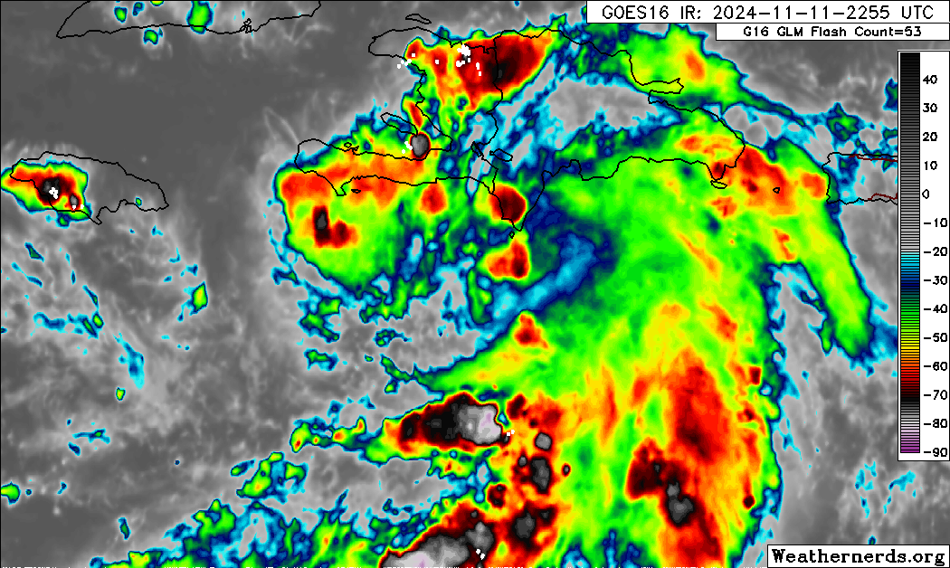
A tropical wave over the central Caribbean Sea is producing an area
of disorganized showers and thunderstorms. Environmental conditions
appear conducive for development, and a tropical depression could
form late this week as the system moves westward into the western
Caribbean Sea. After that, the disturbance is expected to slow down
and meander through the weekend. Interests across the western
Caribbean Sea should monitor the progress of this system.
* Formation chance through 48 hours...low...20 percent.
* Formation chance through 7 days...medium...60 percent.
NWS National Hurricane Center Miami FL
700 PM EST Mon Nov 11 2024
For the North Atlantic...Caribbean Sea and the Gulf of Mexico:
1. Central and Western Caribbean Sea:
A tropical wave over the central Caribbean Sea is producing an area
of disorganized showers and thunderstorms. Environmental conditions
appear conducive for development, and a tropical depression could
form late this week as the system moves westward into the western
Caribbean Sea. After that, the disturbance is expected to slow down
and meander through the weekend. Interests across the western
Caribbean Sea should monitor the progress of this system.
* Formation chance through 48 hours...low...20 percent.
* Formation chance through 7 days...medium...60 percent.
2 likes
-
wzrgirl1

- S2K Supporter

- Posts: 1360
- Joined: Sat Sep 04, 2004 6:44 am
- Location: Pembroke Pines, Florida
Re: Potential development over the SW Caribbean Sea (20/60)
AJC3 wrote:Tropical Weather Outlook
NWS National Hurricane Center Miami FL
700 PM EST Mon Nov 11 2024
For the North Atlantic...Caribbean Sea and the Gulf of Mexico:
1. Central and Western Caribbean Sea:
A tropical wave over the central Caribbean Sea is producing an area
of disorganized showers and thunderstorms. Environmental conditions
appear conducive for development, and a tropical depression could
form late this week as the system moves westward into the western
Caribbean Sea. After that, the disturbance is expected to slow down
and meander through the weekend. Interests across the western
Caribbean Sea should monitor the progress of this system.
* Formation chance through 48 hours...low...20 percent.
* Formation chance through 7 days...medium...60 percent.
Wow! Chances went from 0/20 to 20/60 in less than 24 hours. Not sure I have seen that this season.
3 likes
-
johngaltfla

- Category 5

- Posts: 2073
- Joined: Sun Jul 10, 2005 9:17 pm
- Location: Sarasota County, FL
- Contact:
Re: Potential development over the SW Caribbean Sea (20/60)
AJC3 wrote:Tropical Weather Outlook
NWS National Hurricane Center Miami FL
700 PM EST Mon Nov 11 2024
For the North Atlantic...Caribbean Sea and the Gulf of Mexico:
1. Central and Western Caribbean Sea:
A tropical wave over the central Caribbean Sea is producing an area
of disorganized showers and thunderstorms. Environmental conditions
appear conducive for development, and a tropical depression could
form late this week as the system moves westward into the western
Caribbean Sea. After that, the disturbance is expected to slow down
and meander through the weekend. Interests across the western
Caribbean Sea should monitor the progress of this system.
* Formation chance through 48 hours...low...20 percent.
* Formation chance through 7 days...medium...60 percent.
To quote the meme:
"Aw sh** here we go again"
1 likes
-
Hurricane Mike
- Category 2

- Posts: 675
- Joined: Tue Apr 10, 2018 7:44 am
Re: Potential development over the Western Caribbean Sea (20/60)
Video on the potential Caribbean system
https://www.youtube.com/watch?v=HkFHSYQrxjg
https://www.youtube.com/watch?v=HkFHSYQrxjg
0 likes

Re: Potential development over the Western Caribbean Sea (20/60)
All 3 major model ensembles (Euro, GFS, and CMC) point to high likelihood of Florida Peninsula impact from this system. Still a long way out though at 8-10 days.
2 likes
-
Hurricane2022

- Category 5
- Posts: 2090
- Joined: Tue Aug 23, 2022 11:38 pm
- Location: Araçatuba, Brazil
Re: Potential development over the Western Caribbean Sea (20/60)
Inb4 future sara becomes another sub-900 mb "hypercane" in mid-nov
0 likes
Sorry for the bad English sometimes...!
For reliable and detailed information for any meteorological phenomenon, please consult the National Hurricane Center, Joint Typhoon Warning Center , or your local Meteo Center.
--------
ECCE OMNIA NOVA FACIAM (Ap 21,5).
For reliable and detailed information for any meteorological phenomenon, please consult the National Hurricane Center, Joint Typhoon Warning Center , or your local Meteo Center.
--------
ECCE OMNIA NOVA FACIAM (Ap 21,5).

Re: Potential development over the SW Caribbean Sea (20/60)
johngaltfla wrote:AJC3 wrote:Tropical Weather Outlook
NWS National Hurricane Center Miami FL
700 PM EST Mon Nov 11 2024
For the North Atlantic...Caribbean Sea and the Gulf of Mexico:
1. Central and Western Caribbean Sea:
A tropical wave over the central Caribbean Sea is producing an area
of disorganized showers and thunderstorms. Environmental conditions
appear conducive for development, and a tropical depression could
form late this week as the system moves westward into the western
Caribbean Sea. After that, the disturbance is expected to slow down
and meander through the weekend. Interests across the western
Caribbean Sea should monitor the progress of this system.
* Formation chance through 48 hours...low...20 percent.
* Formation chance through 7 days...medium...60 percent.
To quote the meme:
"Aw sh** here we go again"
Lol
0 likes
Re: Potential development over the Western Caribbean Sea (20/60)
Its percolating out there, tha season continues.
1 likes
Re: Potential development over the Western Caribbean Sea (20/60)
ronjon wrote:All 3 major model ensembles (Euro, GFS, and CMC) point to high likelihood of Florida Peninsula impact from this system. Still a long way out though at 8-10 days.
I sure hope not for yalls sake bro.
0 likes
-
MarioProtVI
- Category 5
- Posts: 1038
- Age: 24
- Joined: Sun Sep 29, 2019 7:33 pm
- Location: New Jersey
Re: Potential development over the Western Caribbean Sea (20/60)
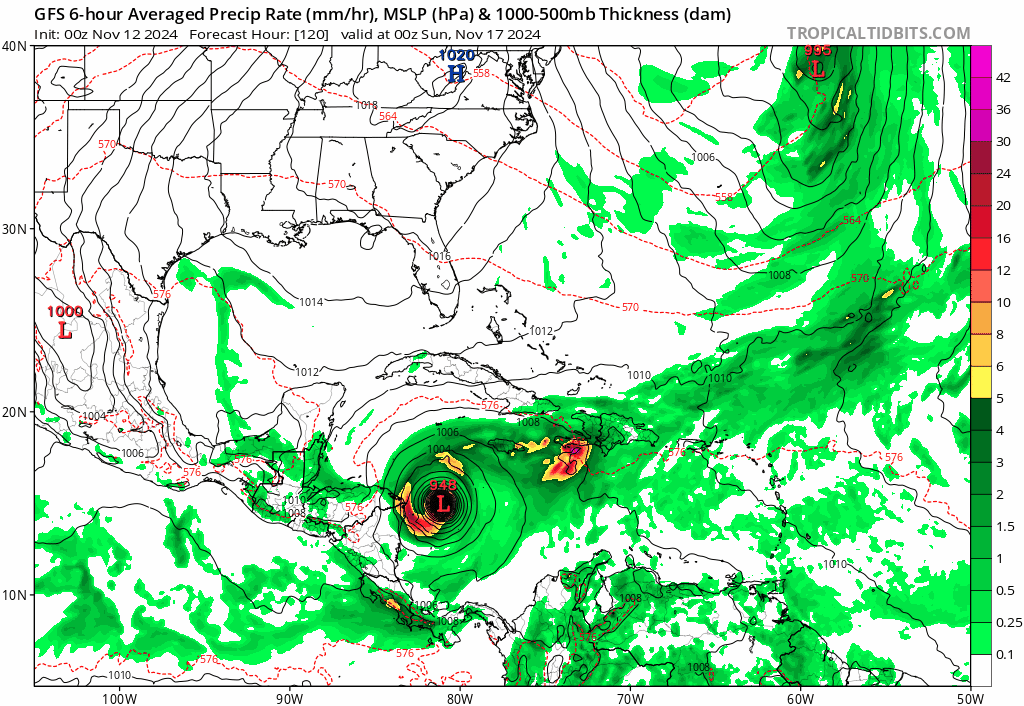
00z GFS just went absolutely bonkers - 930 mb in 144h with Mitch-like ULs and structure. This is legit just November 2020 all over again it seems.
2 likes
-
SFLcane

- S2K Supporter
- Posts: 10281
- Age: 48
- Joined: Sat Jun 05, 2010 1:44 pm
- Location: Lake Worth Florida
Re: Potential development over the Western Caribbean Sea (20/60)
00z gfs with a powerful hurricane into SFL… 
2 likes
-
SouthFLTropics

- Category 5
- Posts: 4258
- Age: 50
- Joined: Thu Aug 14, 2003 8:04 am
- Location: Port St. Lucie, Florida
Re: Potential development over the Western Caribbean Sea (20/60)
This is so surreal... If it wasn't for other model support I'd think the GFS is just trolling us at this point. But ICON, CMC, and Euro are all onboard as well. If it's going to form and be bad girl, at least Jefferson Starship wrote the perfect song for it many years ago... Sara, Sara, storms are brewin in your eyes.
4 likes
Fourth Generation Florida Native
Personal Storm History: David 79, Andrew 92, Erin 95, Floyd 99, Irene 99, Frances 04, Jeanne 04, Wilma 05, Matthew 16, Irma 17, Ian 22, Nicole 22, Milton 24
Personal Storm History: David 79, Andrew 92, Erin 95, Floyd 99, Irene 99, Frances 04, Jeanne 04, Wilma 05, Matthew 16, Irma 17, Ian 22, Nicole 22, Milton 24
Re: Potential development over the Western Caribbean Sea (20/60)
If the GFS track is correct, then the 932mb intensity is definitely impossible. Stalling for 72h will probably upwell the SST to 24 degrees before it turns northwest 
2 likes


Re: Potential development over the Western Caribbean Sea (20/60)
MarioProtVI wrote:00z GFS just went absolutely bonkers - 930 mb in 144h with Mitch-like ULs and structure. This is legit just November 2020 all over again it seems.
November 2020 was nothing compared to what the models show in 2024.
3 likes
Re: Potential development over the Western Caribbean Sea (20/60)
Tropical Weather Outlook
NWS National Hurricane Center Miami FL
100 AM EST Tue Nov 12 2024
For the North Atlantic...Caribbean Sea and the Gulf of Mexico:
1. Central and Western Caribbean Sea:
A tropical wave over the central Caribbean Sea is producing an area
of disorganized showers and thunderstorms. Environmental conditions
appear conducive for development, and a tropical depression will
likely form late this week as the system moves westward into the
western Caribbean Sea. After that, the disturbance is expected to
slow down and meander through the weekend. Interests across the
western Caribbean Sea should monitor the progress of this system.
* Formation chance through 48 hours...low...30 percent.
* Formation chance through 7 days...high...70 percent.
1 likes
Who is online
Users browsing this forum: No registered users and 195 guests