
WPAC: MAN-YI - Post-Tropical
Moderator: S2k Moderators
-
WaveBreaking

- Category 2

- Posts: 727
- Joined: Sun Jun 30, 2024 11:33 am
- Location: US
Re: WPAC: MAN-YI - Typhoon
3 likes
I am NOT a professional meteorologist, so take all of my posts with a grain of salt. My opinions are mine and mine alone.
-
WaveBreaking
- Category 2
- Posts: 727
- Joined: Sun Jun 30, 2024 11:33 am
- Location: US
Re: WPAC: MAN-YI - Typhoon
Stadium effect in full force this morning

1 likes
I am NOT a professional meteorologist, so take all of my posts with a grain of salt. My opinions are mine and mine alone.
-
xtyphooncyclonex

- Category 5

- Posts: 3898
- Age: 24
- Joined: Sat Dec 08, 2012 9:07 am
- Location: Cebu City
- Contact:
Re: WPAC: MAN-YI - Typhoon
Crazy to think this was the same storm expected to dissipate in the open Pacific. Would this be one of the biggest overperformances of any TC?

2 likes
REMINDER: My opinions that I, or any other NON Pro-Met in this forum, are unofficial. Please do not take my opinions as an official forecast and warning. I am NOT a meteorologist. Following my forecasts blindly may lead to false alarm, danger and risk if official forecasts from agencies are ignored.
-
xtyphooncyclonex
- Category 5
- Posts: 3898
- Age: 24
- Joined: Sat Dec 08, 2012 9:07 am
- Location: Cebu City
- Contact:
Re: WPAC: MAN-YI - Typhoon

3 likes
REMINDER: My opinions that I, or any other NON Pro-Met in this forum, are unofficial. Please do not take my opinions as an official forecast and warning. I am NOT a meteorologist. Following my forecasts blindly may lead to false alarm, danger and risk if official forecasts from agencies are ignored.

Re: WPAC: MAN-YI - Typhoon
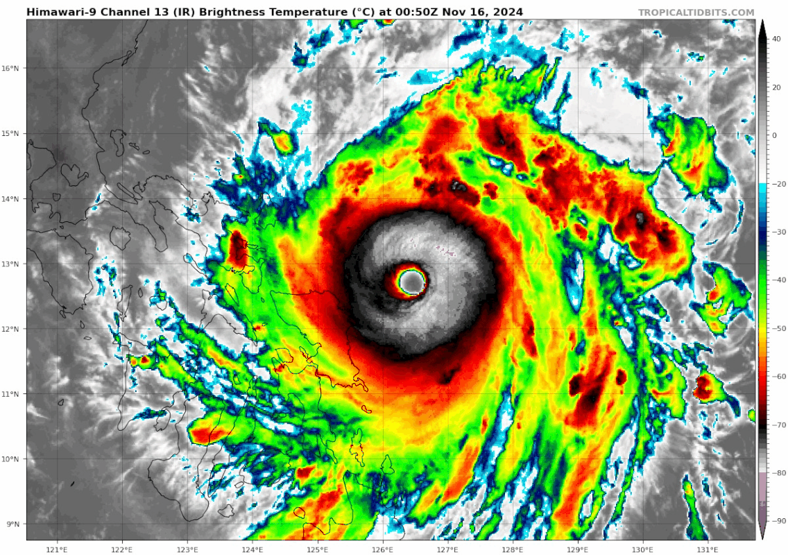
JMA violent
T2424(Man-yi)
Issued at 2024/11/16 01:05 UTC
Analysis at 11/16 00 UTC
Grade TY
Scale -
Intensity Violent
Center position N12°35′ (12.6°)
E126°35′ (126.6°)
Direction and speed of movement WNW 25 km/h (13 kt)
Central pressure 920 hPa
Maximum sustained wind speed near center 55 m/s (105 kt)
Maximum wind gust speed 75 m/s (150 kt)
Radius of 50-kt wind area 130 km (70 NM)
Radius of 30-kt wind area E390 km (210 NM)
W280 km (150 NM)
2 likes
ヤンデレ女が寝取られるているのを見たい!!!
ECMWF ensemble NWPAC plots: https://ecmwfensnwpac.imgbb.com/
Multimodel NWPAC plots: https://multimodelnwpac.imgbb.com/
GFS Ensemble NWPAC plots (16 & 35 day forecast): https://gefsnwpac.imgbb.com/
Plots updated automatically
ECMWF ensemble NWPAC plots: https://ecmwfensnwpac.imgbb.com/
Multimodel NWPAC plots: https://multimodelnwpac.imgbb.com/
GFS Ensemble NWPAC plots (16 & 35 day forecast): https://gefsnwpac.imgbb.com/
Plots updated automatically
Re: WPAC: MAN-YI - Typhoon
Super
25W MAN-YI 241116 0000 12.5N 126.7E WPAC 130 934
2 likes
ヤンデレ女が寝取られるているのを見たい!!!
ECMWF ensemble NWPAC plots: https://ecmwfensnwpac.imgbb.com/
Multimodel NWPAC plots: https://multimodelnwpac.imgbb.com/
GFS Ensemble NWPAC plots (16 & 35 day forecast): https://gefsnwpac.imgbb.com/
Plots updated automatically
ECMWF ensemble NWPAC plots: https://ecmwfensnwpac.imgbb.com/
Multimodel NWPAC plots: https://multimodelnwpac.imgbb.com/
GFS Ensemble NWPAC plots (16 & 35 day forecast): https://gefsnwpac.imgbb.com/
Plots updated automatically
Re: WPAC: MAN-YI - Typhoon
Eye temp in the +20C range
2024NOV15 220000 5.5 958.9 102.0 5.5 5.7 6.9 1.3T/6hr OFF OFF OFF OFF 20.16 -74.84 EYE 19 IR 55.0 12.35 -127.05 ARCHER HIM-9 21.5
2024NOV15 223000 5.7 954.6 107.2 5.7 5.9 6.9 1.3T/6hr OFF OFF OFF OFF 20.18 -74.67 EYE 21 IR 55.0 12.40 -126.95 ARCHER HIM-9 21.6
2024NOV15 230000 5.7 954.6 107.2 5.7 6.0 6.9 1.3T/6hr OFF OFF OFF OFF 21.28 -74.30 EYE 23 IR 55.0 12.45 -126.86 ARCHER HIM-9 21.7
2024NOV15 233000 5.8 952.4 109.8 5.8 6.1 6.8 1.3T/6hr OFF OFF OFF OFF 20.55 -74.08 EYE 22 IR 55.0 12.49 -126.79 ARCHER HIM-9 21.8
2024NOV16 000000 5.9 950.2 112.4 5.9 6.3 6.9 1.3T/6hr OFF OFF OFF OFF 22.31 -74.12 EYE 22 IR 55.0 12.56 -126.69 ARCHER HIM-9 21.9
2024NOV16 003000 6.0 948.0 115.0 6.0 6.4 6.9 1.3T/6hr OFF OFF OFF OFF 22.21 -74.19 EYE 22 IR 55.0 12.61 -126.60 ARCHER HIM-9 22.0
2024NOV16 010000 6.1 945.9 117.4 6.1 6.3 6.9 1.3T/6hr OFF OFF OFF OFF 22.57 -74.45 EYE 22 IR 55.0 12.66 -126.51 ARCHER HIM-9 22.2
0 likes
ヤンデレ女が寝取られるているのを見たい!!!
ECMWF ensemble NWPAC plots: https://ecmwfensnwpac.imgbb.com/
Multimodel NWPAC plots: https://multimodelnwpac.imgbb.com/
GFS Ensemble NWPAC plots (16 & 35 day forecast): https://gefsnwpac.imgbb.com/
Plots updated automatically
ECMWF ensemble NWPAC plots: https://ecmwfensnwpac.imgbb.com/
Multimodel NWPAC plots: https://multimodelnwpac.imgbb.com/
GFS Ensemble NWPAC plots (16 & 35 day forecast): https://gefsnwpac.imgbb.com/
Plots updated automatically
-
Hurricane2022

- Category 5
- Posts: 2090
- Joined: Tue Aug 23, 2022 11:38 pm
- Location: Araçatuba, Brazil
Re: WPAC: MAN-YI - Typhoon
Looking catastrophic and beautiful right now. JTWC should go with 150 - 155 kt in the next warning.
0 likes
Sorry for the bad English sometimes...!
For reliable and detailed information for any meteorological phenomenon, please consult the National Hurricane Center, Joint Typhoon Warning Center , or your local Meteo Center.
--------
ECCE OMNIA NOVA FACIAM (Ap 21,5).
For reliable and detailed information for any meteorological phenomenon, please consult the National Hurricane Center, Joint Typhoon Warning Center , or your local Meteo Center.
--------
ECCE OMNIA NOVA FACIAM (Ap 21,5).
-
ElectricStorm

- Category 5
- Posts: 5152
- Age: 25
- Joined: Tue Aug 13, 2019 11:23 pm
- Location: Norman, OK
Re: WPAC: MAN-YI - Typhoon
With an eye temp that warm I think 130kts is too low, probably at least 140kts now
0 likes
B.S Meteorology, University of Oklahoma '25
Please refer to the NHC, NWS, or SPC for official information.
Please refer to the NHC, NWS, or SPC for official information.
-
mrbagyo

- Category 5
- Posts: 3993
- Age: 33
- Joined: Thu Apr 12, 2012 9:18 am
- Location: 14.13N 120.98E
- Contact:
Re: WPAC: MAN-YI - Typhoon
no way in hell Man-yi is just a 130 knots super typhoon.
This is one of the most symmetrical typhoon I've ever seen.
It's uber hot here in Baler, Aurora
This is one of the most symmetrical typhoon I've ever seen.
It's uber hot here in Baler, Aurora
3 likes
The posts in this forum are NOT official forecast and should not be used as such. They are just the opinion of the poster and may or may not be backed by sound meteorological data. They are NOT endorsed by any professional institution or storm2k.org. For official information, please refer to RSMC, NHC and NWS products.
-
WaveBreaking
- Category 2
- Posts: 727
- Joined: Sun Jun 30, 2024 11:33 am
- Location: US
Re: WPAC: MAN-YI - Typhoon
Reminds me a bit of Zeb (1998)


1 likes
I am NOT a professional meteorologist, so take all of my posts with a grain of salt. My opinions are mine and mine alone.
-
MarioProtVI
- Category 5
- Posts: 1038
- Age: 24
- Joined: Sun Sep 29, 2019 7:33 pm
- Location: New Jersey
Re: WPAC: MAN-YI - Typhoon
Yet another underestimated STY/missed C5 by JTWC and Dvoark. Idk why their analysis is underestimating this by at least 10-15 kt. If recon had flown into both pinhole Usagi and Man-yi right now they’d very likely find Cat 5s in both of them, with Usagi probably being the stronger one.
1 likes
Re: WPAC: MAN-YI - Super Typhoon
TPPN12 PGTW 160318
A. SUPER TYPHOON 25W (MAN-YI)
B. 16/0230Z
C. 12.86N
D. 126.22E
E. ONE/GK2A
F. T7.0/7.0/D2.5/24HRS STT: D0.5/03HRS
G. IR/EIR/VIS/MSI
H. REMARKS: 03A/PBO EYE/ANMTN. WMG EYE SURROUNDED BY W YIELDS AN E#
OF 6.0. ADDED 1.0 EYE ADJUSTMENT FOR W, TO YIELD A DT OF 7.0. MET
YIELDS 6.0. PT YIELDS 7.0. DBO DT.
I. ADDITIONAL POSITIONS: NONE
EL-NAZLY
1 likes

Re: WPAC: MAN-YI - Typhoon
mrbagyo wrote:no way in hell Man-yi is just a 130 knots super typhoon.
This is one of the most symmetrical typhoon I've ever seen.
It's uber hot here in Baler, Aurora
Looks to me like a 145 to 155 knot typhoon.
Philippines cannot catch a break from typhoons.
0 likes
-
Hurricane2022
- Category 5
- Posts: 2090
- Joined: Tue Aug 23, 2022 11:38 pm
- Location: Araçatuba, Brazil
Re: WPAC: MAN-YI - Typhoon
https://x.com/zeb199818/status/1857646173038981469
https://x.com/zeb199818/status/1857650993544184193
https://x.com/zeb199818/status/1857650993544184193
0 likes
Sorry for the bad English sometimes...!
For reliable and detailed information for any meteorological phenomenon, please consult the National Hurricane Center, Joint Typhoon Warning Center , or your local Meteo Center.
--------
ECCE OMNIA NOVA FACIAM (Ap 21,5).
For reliable and detailed information for any meteorological phenomenon, please consult the National Hurricane Center, Joint Typhoon Warning Center , or your local Meteo Center.
--------
ECCE OMNIA NOVA FACIAM (Ap 21,5).
-
Ed_2001

- Tropical Storm

- Posts: 246
- Age: 24
- Joined: Wed Jun 21, 2017 11:39 pm
- Location: Santa Barbara, CA>>Tampa, FL
Re: WPAC: MAN-YI - Typhoon
With Man-yi 2024 just quietly sneaked into a somewhat exclusive club mostly dominated by above average years -- the first since 2018 to see at least 6 (arguably 7) STY's. Pretty telling that none of the years so far with 6+ STY's generated less than 262 units of ACE.
(wikipedia coloring scheme does seen to be a bit down-skewed, showing ~275 as above average and ~190 as near average)
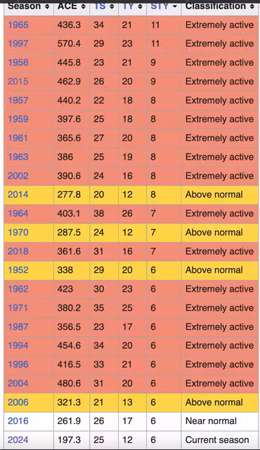
(wikipedia coloring scheme does seen to be a bit down-skewed, showing ~275 as above average and ~190 as near average)
Last edited by Ed_2001 on Sat Nov 16, 2024 3:51 am, edited 1 time in total.
2 likes
The answer my friend, is blowing in the wind...

Re: WPAC: MAN-YI - Typhoon
1 likes
TC naming lists: retirements and intensity
Most aggressive Advisory #1's in North Atlantic (cr. kevin for starting the list)
Most aggressive Advisory #1's in North Atlantic (cr. kevin for starting the list)
Re: WPAC: MAN-YI - Typhoon
Cat 5
25W MAN-YI 241116 0600 13.2N 125.6E WPAC 140 923
1 likes
ヤンデレ女が寝取られるているのを見たい!!!
ECMWF ensemble NWPAC plots: https://ecmwfensnwpac.imgbb.com/
Multimodel NWPAC plots: https://multimodelnwpac.imgbb.com/
GFS Ensemble NWPAC plots (16 & 35 day forecast): https://gefsnwpac.imgbb.com/
Plots updated automatically
ECMWF ensemble NWPAC plots: https://ecmwfensnwpac.imgbb.com/
Multimodel NWPAC plots: https://multimodelnwpac.imgbb.com/
GFS Ensemble NWPAC plots (16 & 35 day forecast): https://gefsnwpac.imgbb.com/
Plots updated automatically
-
mrbagyo
- Category 5
- Posts: 3993
- Age: 33
- Joined: Thu Apr 12, 2012 9:18 am
- Location: 14.13N 120.98E
- Contact:
Re: WPAC: MAN-YI - Typhoon
Cirrus clouds streaking all over the sky here in Baler this afternoon.

1 likes
The posts in this forum are NOT official forecast and should not be used as such. They are just the opinion of the poster and may or may not be backed by sound meteorological data. They are NOT endorsed by any professional institution or storm2k.org. For official information, please refer to RSMC, NHC and NWS products.


Who is online
Users browsing this forum: No registered users and 77 guests