Texas Winter 2024-2025

Winter Weather Discussion

Moderator: S2k Moderators

Forum rules

The posts in this forum are NOT official forecast and should not be used as such. They are just the opinion of the poster and may or may not be backed by sound meteorological data. They are NOT endorsed by any professional institution or
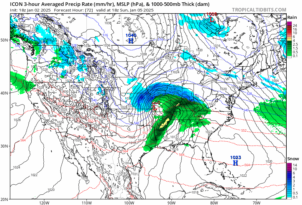
 STORM2K.

Help Support Storm2K
Message
Author
rwfromkansas
Category 5
Category 5
Posts: 2628
Joined: Sat Aug 27, 2005 12:47 am
Location: North Fort Worth

Re: Texas Winter 2024-2025

#1941 Postby rwfromkansas » Thu Jan 02, 2025 9:06 pm

Ntxw wrote:
Brandon8181 wrote:
HockeyTx82 wrote:
I'm not the expert and somebody else will probably add, but they manually do all those forecasts versus a computer outputting it, so it takes time for them to update everything. Right now that's just the safe forecast because that's the typical day that we would most likely have this far out.


I get that. I really do. Obviously, them sounded the alarm vs our chatter here is completely different. I just, feel like at this time atleast a Rain/Snow mix picture with highs in the 40's is appropriate for Thursday. 10%

It just seems like the confidence would be enough for a mention.


Not 100% certain but over the years I have noticed they often follow MOS statistical guidance in their forecasts. It's a statistical approach rather than purely dynamical/NWP model forecasts, what you and I are used to seeing. It has climo involved a lot and they adjust subtly. If you ever heard of 'stat' method from Steve McCauley it's a similar approach. From a NWS forecasting perspective it's very much about probability rather than possibility all the time.


When I was reading the Wichita discussions about the Kansas storm, they seem much less focused on probability. It doesn't seem to be their main focus, unlike FWD.
1 likes   

User avatar
Ntxw
Storm2k Moderator
Storm2k Moderator
Posts: 22792
Joined: Wed Oct 21, 2009 6:34 pm
Location: DFW, Texas

Re: Texas Winter 2024-2025

#1942 Postby Ntxw » Thu Jan 02, 2025 9:09 pm

rwfromkansas wrote:
Ntxw wrote:
Brandon8181 wrote:
I get that. I really do. Obviously, them sounded the alarm vs our chatter here is completely different. I just, feel like at this time atleast a Rain/Snow mix picture with highs in the 40's is appropriate for Thursday. 10%

It just seems like the confidence would be enough for a mention.


Not 100% certain but over the years I have noticed they often follow MOS statistical guidance in their forecasts. It's a statistical approach rather than purely dynamical/NWP model forecasts, what you and I are used to seeing. It has climo involved a lot and they adjust subtly. If you ever heard of 'stat' method from Steve McCauley it's a similar approach. From a NWS forecasting perspective it's very much about probability rather than possibility all the time.


When I was reading the Wichita discussions about the Kansas storm, they seem much less focused on probability. It doesn't seem to be their main focus, unlike FWD.


MOS products can adjust as well, once it starts producing high percentages they'll get more bold. Statistical forecast doesn't mean it can't show a high impact event, it's just more smoothed the longer out you go.
2 likes   
The above post and any post by Ntxw is NOT an official forecast and should not be used as such. It is just the opinion of the poster and may or may not be backed by sound meteorological data. It is NOT endorsed by any professional institution including Storm2k. For official information, please refer to NWS products.

  Help support Storm2K!
Help Support Storm2K

gpsnowman
S2K Supporter
S2K Supporter
Posts: 3191
Joined: Fri Jan 07, 2011 10:35 am
Location: Grand Prairie Tx

Re: Texas Winter 2024-2025

#1943 Postby gpsnowman » Thu Jan 02, 2025 9:11 pm

Ntxw wrote:
Brandon8181 wrote:
HockeyTx82 wrote:
I'm not the expert and somebody else will probably add, but they manually do all those forecasts versus a computer outputting it, so it takes time for them to update everything. Right now that's just the safe forecast because that's the typical day that we would most likely have this far out.


I get that. I really do. Obviously, them sounded the alarm vs our chatter here is completely different. I just, feel like at this time atleast a Rain/Snow mix picture with highs in the 40's is appropriate for Thursday. 10%

It just seems like the confidence would be enough for a mention.


Not 100% certain but over the years I have noticed they often follow MOS statistical guidance in their forecasts. It's a statistical approach rather than purely dynamical/NWP model forecasts, what you and I are used to seeing. It has climo involved a lot and they adjust subtly. If you ever heard of 'stat' method from Steve McCauley it's a similar approach. From a NWS forecasting perspective it's very much about probability rather than possibility all the time.

Speaking of Steve McCauley he has not made a FB post in a while. Usually he chimes in frequently when a winter weather event is potentially near.
2 likes   

HockeyTx82
S2K Supporter
S2K Supporter
Posts: 2541
Joined: Tue Oct 27, 2009 11:17 am
Location: Ponder, TX

Re: Texas Winter 2024-2025

#1944 Postby HockeyTx82 » Thu Jan 02, 2025 9:12 pm

I see my old Ponder neighbor is on the board tonight. :ggreen:
2 likes   
Don't hold me accountable for anything I post on this forum. Leave the real forecasting up to the professionals.

Location: Ponder, TX (all observation posts are this location unless otherwise noted)

Brandon8181
S2K Supporter
S2K Supporter
Posts: 424
Age: 41
Joined: Tue Jan 04, 2011 4:52 pm
Location: Tyler, TX
Contact:

Re: Texas Winter 2024-2025

#1945 Postby Brandon8181 » Thu Jan 02, 2025 9:25 pm

https://www.tropicaltidbits.com/analysis/models/sounding/?model=gfs&runtime=2025010218&fh=168&lat=32.34&lon=-95.34&stationID=&tc=&mode=regular

Would anyone mind providing me some guidance on this sounding? I've never learned to read them.
0 likes   
I am not a meteorologist. Any post from me should be taken as hobby or fun educational information, but not an accurate source for weather information. Please, refer to your local weather station or National Weather Service for the most up to date information. :flag:

HockeyTx82
S2K Supporter
S2K Supporter
Posts: 2541
Joined: Tue Oct 27, 2009 11:17 am
Location: Ponder, TX

Re: Texas Winter 2024-2025

#1946 Postby HockeyTx82 » Thu Jan 02, 2025 9:33 pm

Brandon8181 wrote:https://www.tropicaltidbits.com/analysis/models/sounding/?model=gfs&runtime=2025010218&fh=168&lat=32.34&lon=-95.34&stationID=&tc=&mode=regular

Would anyone mind providing me some guidance on this sounding? I've never learned to read them.


Sure thing! This image is a Skew-T log-P diagram, a tool meteorologists use to understand the atmosphere and predict weather. Here's a breakdown:

**Main Graph (left):**
- **Pressure (y-axis)**: Pressure decreases as you go up in the atmosphere.
- **Temperature (x-axis)**: Horizontal lines show temperature in degrees Celsius.
- **Red Line**: The actual temperature at different heights.
- **Green Line**: The dew point temperature, which indicates moisture.
- **Blue Line**: The wet-bulb temperature, which combines temperature and humidity.
- **Purple Dashed Line**: The theoretical path of a parcel of air if it rises.
- **Wind Barbs (right)**: Show wind speed and direction at various heights.

**Inset Graphs:**
- **Top Right**: A hodograph showing wind speed and direction changes with height.
- **Bottom Right**: The equivalent potential temperature profile.

**Key Parameters:**
- **CAPE (Convective Available Potential Energy)**: Indicates energy for storms.
- **SRH (Storm Relative Helicity)**: Shows potential for rotating storms (tornadoes).
- **PWAT (Precipitable Water)**: Total water vapor in a column of air.

These elements help meteorologists assess storm potential and atmospheric stability. If you have any specific questions about this, let me know!
2 likes   
Don't hold me accountable for anything I post on this forum. Leave the real forecasting up to the professionals.

Location: Ponder, TX (all observation posts are this location unless otherwise noted)

Brandon8181
S2K Supporter
S2K Supporter
Posts: 424
Age: 41
Joined: Tue Jan 04, 2011 4:52 pm
Location: Tyler, TX
Contact:

Re: Texas Winter 2024-2025

#1947 Postby Brandon8181 » Thu Jan 02, 2025 9:37 pm

HockeyTx82 wrote:
Brandon8181 wrote:https://www.tropicaltidbits.com/analysis/models/sounding/?model=gfs&runtime=2025010218&fh=168&lat=32.34&lon=-95.34&stationID=&tc=&mode=regular

Would anyone mind providing me some guidance on this sounding? I've never learned to read them.


Sure thing! This image is a Skew-T log-P diagram, a tool meteorologists use to understand the atmosphere and predict weather. Here's a breakdown:

**Main Graph (left):**
- **Pressure (y-axis)**: Pressure decreases as you go up in the atmosphere.
- **Temperature (x-axis)**: Horizontal lines show temperature in degrees Celsius.
- **Red Line**: The actual temperature at different heights.
- **Green Line**: The dew point temperature, which indicates moisture.
- **Blue Line**: The wet-bulb temperature, which combines temperature and humidity.
- **Purple Dashed Line**: The theoretical path of a parcel of air if it rises.
- **Wind Barbs (right)**: Show wind speed and direction at various heights.

**Inset Graphs:**
- **Top Right**: A hodograph showing wind speed and direction changes with height.
- **Bottom Right**: The equivalent potential temperature profile.

**Key Parameters:**
- **CAPE (Convective Available Potential Energy)**: Indicates energy for storms.
- **SRH (Storm Relative Helicity)**: Shows potential for rotating storms (tornadoes).
- **PWAT (Precipitable Water)**: Total water vapor in a column of air.

These elements help meteorologists assess storm potential and atmospheric stability. If you have any specific questions about this, let me know!


Thank you so much for the wonderful explanation :)
1 likes   
I am not a meteorologist. Any post from me should be taken as hobby or fun educational information, but not an accurate source for weather information. Please, refer to your local weather station or National Weather Service for the most up to date information. :flag:

Ralph's Weather
S2K Supporter
S2K Supporter
Posts: 3269
Age: 38
Joined: Fri Dec 13, 2013 11:55 am
Location: Lindale, TX
Contact:

Re: Texas Winter 2024-2025

#1948 Postby Ralph's Weather » Thu Jan 02, 2025 9:37 pm

Brandon8181 wrote:https://www.tropicaltidbits.com/analysis/models/sounding/?model=gfs&runtime=2025010218&fh=168&lat=32.34&lon=-95.34&stationID=&tc=&mode=regular

Would anyone mind providing me some guidance on this sounding? I've never learned to read them.

It shows a saturated column that's all sub freezing. It does indicate some near freezing air at mid levels so a touch warmer and sleet would mix in.
2 likes   
Follow on Facebook at Ralph's Weather.

HockeyTx82
S2K Supporter
S2K Supporter
Posts: 2541
Joined: Tue Oct 27, 2009 11:17 am
Location: Ponder, TX

Re: Texas Winter 2024-2025

#1949 Postby HockeyTx82 » Thu Jan 02, 2025 9:38 pm

Brandon8181 wrote:https://www.tropicaltidbits.com/analysis/models/sounding/?model=gfs&runtime=2025010218&fh=168&lat=32.34&lon=-95.34&stationID=&tc=&mode=regular

Would anyone mind providing me some guidance on this sounding? I've never learned to read them.


Just so you know I took that picture, uploaded it into co-pilot and started asking it questions based off the picture so that was a complete AI output. You might want to try doing that with some things and see what you come up with. I've learned quite a bit and then confirmed it on here with others.
1 likes   
Don't hold me accountable for anything I post on this forum. Leave the real forecasting up to the professionals.

Location: Ponder, TX (all observation posts are this location unless otherwise noted)

User avatar
Ntxw
Storm2k Moderator
Storm2k Moderator
Posts: 22792
Joined: Wed Oct 21, 2009 6:34 pm
Location: DFW, Texas

Re: Texas Winter 2024-2025

#1950 Postby Ntxw » Thu Jan 02, 2025 9:45 pm

HockeyTx82 wrote:
Brandon8181 wrote:https://www.tropicaltidbits.com/analysis/models/sounding/?model=gfs&runtime=2025010218&fh=168&lat=32.34&lon=-95.34&stationID=&tc=&mode=regular

Would anyone mind providing me some guidance on this sounding? I've never learned to read them.


Just so you know I took that picture, uploaded it into co-pilot and started asking it questions based off the picture so that was a complete AI output. You might want to try doing that with some things and see what you come up with. I've learned quite a bit and then confirmed it on here with others.


Dewpoint and temperature lines are in aligned, which means the column is moist and precipitating. The two lines are below 0C (freezing; follow the dashed lines from 0, diagonally to the right and up.) DGZ (dendritic growth zone where snow is made from -10C to -20C) is roughly 650mb to 500mb or 6k-18k feet up. Quick interpretation. In short a good sounding for snow being made and falling to the ground.
3 likes   
The above post and any post by Ntxw is NOT an official forecast and should not be used as such. It is just the opinion of the poster and may or may not be backed by sound meteorological data. It is NOT endorsed by any professional institution including Storm2k. For official information, please refer to NWS products.


  Help support Storm2K!

Help Support Storm2K


Brandon8181
S2K Supporter
S2K Supporter
Posts: 424
Age: 41
Joined: Tue Jan 04, 2011 4:52 pm
Location: Tyler, TX
Contact:

Re: Texas Winter 2024-2025

#1951 Postby Brandon8181 » Thu Jan 02, 2025 9:53 pm

This is the first I've seen from a TV meteorologist on this system:

CBS 19 in Tyler meteorologist Brett Anthony:
Texas snow rules and medium range models coming into agreement are lending toward more confidence in East Texas seeing at least a rain/snow mix in the middle of next week. Way too early to talk about impacts and amounts but we've got time to hammer that out. Definitely cold enough for snow, sleet or freezing rain.

He posted this along with one of the more extreme model shows.
1 likes   
I am not a meteorologist. Any post from me should be taken as hobby or fun educational information, but not an accurate source for weather information. Please, refer to your local weather station or National Weather Service for the most up to date information. :flag:

snownado
Category 2
Category 2
Posts: 796
Joined: Sat Dec 09, 2023 7:00 pm
Location: Plano, TX

Re: Texas Winter 2024-2025

#1952 Postby snownado » Thu Jan 02, 2025 10:39 pm

Ntxw wrote:
HockeyTx82 wrote:
Brandon8181 wrote:https://www.tropicaltidbits.com/analysis/models/sounding/?model=gfs&runtime=2025010218&fh=168&lat=32.34&lon=-95.34&stationID=&tc=&mode=regular

Would anyone mind providing me some guidance on this sounding? I've never learned to read them.


Just so you know I took that picture, uploaded it into co-pilot and started asking it questions based off the picture so that was a complete AI output. You might want to try doing that with some things and see what you come up with. I've learned quite a bit and then confirmed it on here with others.


Dewpoint and temperature lines are in aligned, which means the column is moist and precipitating. The two lines are below 0C (freezing; follow the dashed lines from 0, diagonally to the right and up.) DGZ (dendritic growth zone where snow is made from -10C to -20C) is roughly 650mb to 500mb or 6k-18k feet up. Quick interpretation. In short a good sounding for snow being made and falling to the ground.


Not ideal for heavy snowfall rates (and thus accumulation) though, as dendrites that high up will get ripped to shreds by the Jet (reducing ratios) and it's going to take a fair amoumt of time to saturate the column down to the ground.
Last edited by snownado on Thu Jan 02, 2025 10:41 pm, edited 2 times in total.
0 likes   

Brandon8181
S2K Supporter
S2K Supporter
Posts: 424
Age: 41
Joined: Tue Jan 04, 2011 4:52 pm
Location: Tyler, TX
Contact:

Re: Texas Winter 2024-2025

#1953 Postby Brandon8181 » Thu Jan 02, 2025 10:39 pm

00z Icon keeps Snow storm generally south/central Texas
0 likes   
I am not a meteorologist. Any post from me should be taken as hobby or fun educational information, but not an accurate source for weather information. Please, refer to your local weather station or National Weather Service for the most up to date information. :flag:

Stratton23
Category 5
Category 5
Posts: 2551
Joined: Fri Jul 21, 2023 10:59 pm
Location: Katy, Tx

Re: Texas Winter 2024-2025

#1954 Postby Stratton23 » Thu Jan 02, 2025 10:40 pm

00z ICON is a full on snowstorm for central and se texas
3 likes   

Brandon8181
S2K Supporter
S2K Supporter
Posts: 424
Age: 41
Joined: Tue Jan 04, 2011 4:52 pm
Location: Tyler, TX
Contact:

Re: Texas Winter 2024-2025

#1955 Postby Brandon8181 » Thu Jan 02, 2025 10:44 pm

Stratton23 wrote:00z ICON is a full on snowstorm for central and se texas


It makes me wonder if FW is more following the ICON solution because they recently posted a graphic speaking of main travel issues across central Texas.
1 likes   
I am not a meteorologist. Any post from me should be taken as hobby or fun educational information, but not an accurate source for weather information. Please, refer to your local weather station or National Weather Service for the most up to date information. :flag:

Harp.1
Tropical Storm
Tropical Storm
Posts: 207
Joined: Tue Dec 12, 2023 12:37 am

Re: Texas Winter 2024-2025

#1956 Postby Harp.1 » Thu Jan 02, 2025 10:48 pm

South Louisiana loves some ICON!!!
1 likes   

orangeblood
S2K Supporter
S2K Supporter
Posts: 3714
Joined: Tue Dec 15, 2009 6:14 pm
Location: Fort Worth, TX

Re: Texas Winter 2024-2025

#1957 Postby orangeblood » Thu Jan 02, 2025 10:49 pm

Brandon8181 wrote:
Stratton23 wrote:00z ICON is a full on snowstorm for central and se texas


It makes me wonder if FW is more following the ICON solution because they recently posted a graphic speaking of main travel issues across central Texas.


Hugging the ensemble mean precip output at this point which is the smart approach at this point
3 likes   

User avatar
Iceresistance
Category 5
Category 5
Posts: 9290
Age: 21
Joined: Sat Oct 10, 2020 9:45 am
Location: Tecumseh, OK/Norman, OK

Re: Texas Winter 2024-2025

#1958 Postby Iceresistance » Thu Jan 02, 2025 10:53 pm

Now that is a huge jump SW on the ICON, maybe I could get some action now! :lol:

Image
https://s13.gifyu.com/images/SXTrM.gif
3 likes   
Bill 2015 & Beta 2020

Winter 2020-2021 :cold:

All observations are in Tecumseh, OK unless otherwise noted.

Winter posts are focused mainly for Oklahoma & Texas.

Take any of my forecasts with a grain of salt, refer to the NWS, SPC, and NHC for official information

Never say Never with weather! Because ANYTHING is possible!

User avatar
Ntxw
Storm2k Moderator
Storm2k Moderator
Posts: 22792
Joined: Wed Oct 21, 2009 6:34 pm
Location: DFW, Texas

Re: Texas Winter 2024-2025

#1959 Postby Ntxw » Thu Jan 02, 2025 10:54 pm

Iceresistance wrote:Now that is a huge jump SW on the ICON, maybe I could get some action now! :lol:

https://s13.gifyu.com/images/SXTrM.gif


This storm is looking really intense, it's been trending deeper. I would not at all be surprised if blizzard watches/warnings were to be put in place for parts of Kansas, Oklahoma, and Missouri.
3 likes   
The above post and any post by Ntxw is NOT an official forecast and should not be used as such. It is just the opinion of the poster and may or may not be backed by sound meteorological data. It is NOT endorsed by any professional institution including Storm2k. For official information, please refer to NWS products.


  Help support Storm2K!

Help Support Storm2K


Brandon8181
S2K Supporter
S2K Supporter
Posts: 424
Age: 41
Joined: Tue Jan 04, 2011 4:52 pm
Location: Tyler, TX
Contact:

Re: Texas Winter 2024-2025

#1960 Postby Brandon8181 » Thu Jan 02, 2025 10:56 pm

Ntxw wrote:
Iceresistance wrote:Now that is a huge jump SW on the ICON, maybe I could get some action now! :lol:

https://s13.gifyu.com/images/SXTrM.gif


This storm is looking really intense, it's been trending deeper. I would not at all be surprised if blizzard watches/warnings were to be put in place for parts of Kansas, Oklahoma, and Missouri.


Agreed. Lots of intense wrap around, very close isobars, and very deep coloration. Nice model agreement on that system to. Looks like its going to be a mess in those portions of Oklahoma.
0 likes   
I am not a meteorologist. Any post from me should be taken as hobby or fun educational information, but not an accurate source for weather information. Please, refer to your local weather station or National Weather Service for the most up to date information. :flag:


Return to “Winter Weather”

Who is online

Users browsing this forum: No registered users and 27 guests