#3988 Postby BradKingK » Wed Jan 08, 2025 4:45 pm
Looks like SHV NWS is no closer to definitive solutions to this quagmire.
National Weather Service Shreveport LA
309 PM CST Wed Jan 8 2025
...New SHORT TERM, LONG TERM...
.SHORT TERM...
(This evening through Thursday Night)
Issued at 141 PM CST Wed Jan 8 2025
The time is almost at hand that we can put this winter storm in
the rear view mirror and get back to seasonable temperatures. But
first we need to get through it I guess. Here are the main changes
made to the forecast this afternoon. The Winter Storm Warning has
been expanded southward to include most of the I-20 corridor till
you get past Minden, LA. In addition to this, I have issued a
Winter Weather Advisory for a row of counties/parishes south of
the current Warning. This includes Cherokee, Rusk, Panola, De
Soto, Red River, Bienville, Jackson, Ouachita, Lincoln, and Union.
The main reason for the southern expansion is to account for the
trends in potential ice accumulation. Models were a little more
bullish with ice accumulation, especially for our east Texas
counties added to the Advisory. While criteria might not be met
widespread across all the Advisory counties and parishes, I think
that it will be met in at least the northern portions of the
counties/parishes.
Let`s discuss timing first, looks like things will get going
Thursday morning across our western zones before spreading
eastward and becoming more widespread by late morning and early
afternoon. At the onset of precipitation, looks like most of it
could be in the way of wintry precipitation. As we move later
into the morning and into the afternoon hours, it all depends on
where the 32 degree line sets up. Right now it looks like it will
move well north of the I-20 corridor by Thursday afternoon and
could set up as far as the Louisiana/Arkansas border. By the
evening and overnight hours, this line will linger back towards
the I-20 corridor and will make all the difference on what type of
precipitation falls and where. This is where the majority of our
lower confidence remains. I am pretty confident that things near
and north of I-30 will remain all wintry, while areas between I-20
and I-30 will be a wide variety of mixes at times. Once you get
below I-20, thinking is that during the day Thursday most of this
area will be all rain. As we move into the overnight hours, things
will all depend once again where that line sets up.
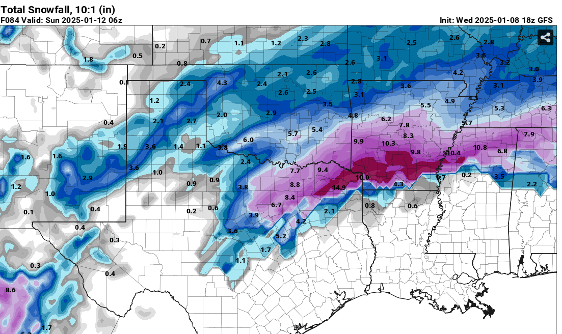
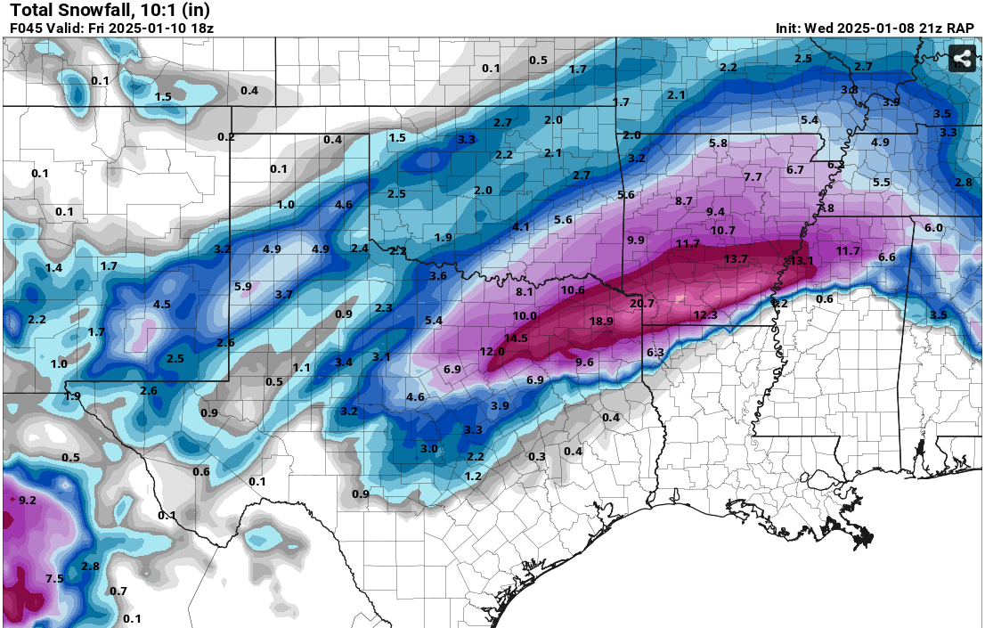
Right now snow accumulations in the Winter Storm Warning area will
range anywhere from 2-8 inches with the higher amounts expected
across the northern part of the Warning area and the lower amounts
to the southern part of this area. Ice accumulations will vary,
again dependent on where the 32 degree line sets up but overall
accumulations across the Winter Storm Warning area will be up to a
quarter of an inch while areas in the Advisory will be around a
tenth of an inch. There is still some potential that things could
change with future model runs so it is important to continue to
follow the forecast for the latest information and check out our
social media pages for images that go along with this system. /33/
3 likes
 The posts in this forum are NOT official forecast and should not be used as such. They are just the opinion of the poster and may or may not be backed by sound meteorological data. They are NOT endorsed by any professional institution or


