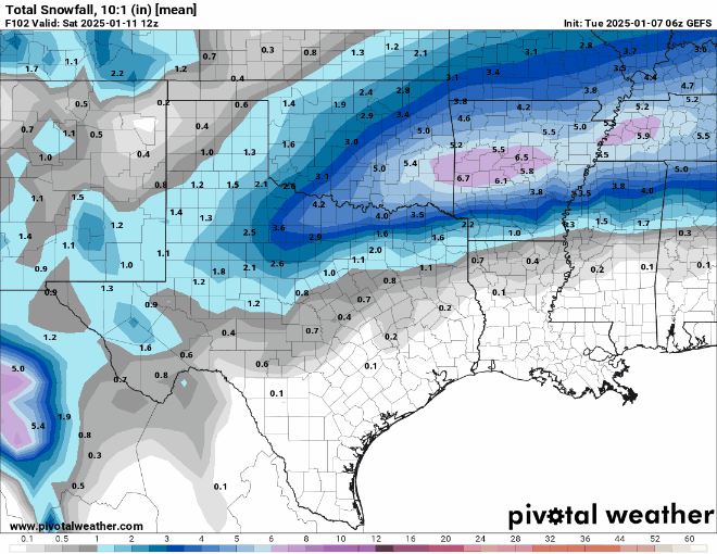
Iceresistance wrote:GEFS jumped north and west, and the bullseye is just to my east!
https://s7.gifyu.com/images/SXZTd.png
https://s7.gifyu.com/images/SXZTd.png
Gross.
Moderator: S2k Moderators
 The posts in this forum are NOT official forecast and should not be used as such. They are just the opinion of the poster and may or may not be backed by sound meteorological data. They are NOT endorsed by any professional institution or STORM2K.
Iceresistance wrote:GEFS jumped north and west, and the bullseye is just to my east!
https://s7.gifyu.com/images/SXZTd.png
https://s7.gifyu.com/images/SXZTd.png


Brent wrote:All those years of bad trends here and look at this...
We don't just get a good trend we get a crazy trend
As far as I know the schools are open tomorrow still


txtwister78 wrote:For those of us further south who are hoping to cash in on some winter weather .... CFS pretty bullish. Cold and precip galore. Not a bad signal. GFS extended looks similar.
https://images.weatherbell.com/model/cfs-daily-all-avg/conus/t2m_f_anom_5day/1736359200/1737590400-d0H3w72NbKk.png
https://images.weatherbell.com/model/cfs-daily-all-avg/conus/total_precip_percent_anom_5day_from_prate/1736359200/1737590400-mRbJ4ZsZYoU.png
Winter_Wisher wrote:Where is the best place to buy an F5 button? Mine seems to have broken.
Gotwood wrote:Man I should have just gone to bed early feel like Im getting cut watching the temp go up. Got down to 28 now it’s back up to 30. 80% humidity think our friends north and East that have dropped in the mid 20s will really cash in.
Iceresistance wrote:GEFS jumped north and west, and the bullseye is just to my east!
https://s7.gifyu.com/images/SXZTd.png
https://s7.gifyu.com/images/SXZTd.png

HockeyTx82 wrote:Iceresistance wrote:GEFS jumped north and west, and the bullseye is just to my east!
https://s7.gifyu.com/images/SXZTd.png
https://s7.gifyu.com/images/SXZTd.png
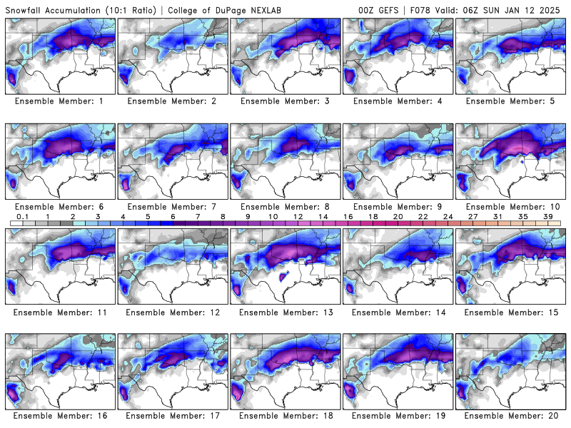
Okay seriously what's going on? I fall asleep on the couch and I wake up and now snow is in Oklahoma? Is this a trend or just one run?
What's the HRRR doing?


Ntxw wrote:One last hurrah from the Euro. It actually doesn't mix that much except onset out west/southwest. There is a period tomorrow afternoon peak day the rain/snow line (nothing in between) creeps to about I-30 then sharply shifts back south to all snow.
That's a wrap for me tonight.
https://i.imgur.com/12J3sTX.png
Harp.1 wrote:Long range Euro? Anything promising?
Ralph's Weather wrote:No models besides crazy Canadian are close to cold enough at initialization. Canadian is way too cold. Bizarre that all hi res models are initializing around 4 degrees warm right now. Most models have freeze line along I20 when it is actually south of Lufkin. 26 here in Lindale along I20 now. Some stations as low as 23 around East Texas.
Users browsing this forum: No registered users and 59 guests


