
SIO: ERROL - Post-Tropical
Moderator: S2k Moderators
-
cycloneye

- Admin

- Posts: 149276
- Age: 69
- Joined: Thu Oct 10, 2002 10:54 am
- Location: San Juan, Puerto Rico
Re: SIO: ERROL - Tropical Cyclone
First visible images shows that very tiny eye.
3 likes
Visit the Caribbean-Central America Weather Thread where you can find at first post web cams,radars
and observations from Caribbean basin members Click Here
and observations from Caribbean basin members Click Here

Re: SIO: ERROL - Tropical Cyclone
This is the kind of storm that has overperformance written all over it, even if not as insane as the long-range HAFS runs a few days ago.

3 likes
TC naming lists: retirements and intensity
Most aggressive Advisory #1's in North Atlantic (cr. kevin for starting the list)
Most aggressive Advisory #1's in North Atlantic (cr. kevin for starting the list)
-
Hurricane2022

- Category 5

- Posts: 2016
- Joined: Tue Aug 23, 2022 11:38 pm
- Location: Araçatuba, Brazil
Re: SIO: ERROL - Tropical Cyclone
1 likes
Sorry for the bad English sometimes...!
For reliable and detailed information for any meteorological phenomenon, please consult the National Hurricane Center, Joint Typhoon Warning Center , or your local Meteo Center.
--------
ECCE OMNIA NOVA FACIAM (Ap 21,5).
For reliable and detailed information for any meteorological phenomenon, please consult the National Hurricane Center, Joint Typhoon Warning Center , or your local Meteo Center.
--------
ECCE OMNIA NOVA FACIAM (Ap 21,5).
-
cycloneye
- Admin
- Posts: 149276
- Age: 69
- Joined: Thu Oct 10, 2002 10:54 am
- Location: San Juan, Puerto Rico
Re: SIO: ERROL - Tropical Cyclone
It has to be much more that 80kt.
29S ERROL 250416 0000 14.1S 119.7E SHEM 80 976
2 likes
Visit the Caribbean-Central America Weather Thread where you can find at first post web cams,radars
and observations from Caribbean basin members Click Here
and observations from Caribbean basin members Click Here
-
WaveBreaking

- Category 2

- Posts: 717
- Joined: Sun Jun 30, 2024 11:33 am
- Location: US
Re: SIO: ERROL - Tropical Cyclone
Maybe those bonkers HAFS runs were onto something


2 likes
I am NOT a professional meteorologist, so take all of my posts with a grain of salt. My opinions are mine and mine alone.


Re: SIO: ERROL - Tropical Cyclone
cycloneye wrote:It has to be much more that 80kt.29S ERROL 250416 0000 14.1S 119.7E SHEM 80 976
The JTWC's last Dvorak fix was a T5.0, with a note acknowledging ongoing RI, and Errol's appearanc has only improved - and substantially - in the two hours since then. It's hard to imagine 1-minute sustained winds being less than 90kt right now.
1 likes
-
cycloneye
- Admin
- Posts: 149276
- Age: 69
- Joined: Thu Oct 10, 2002 10:54 am
- Location: San Juan, Puerto Rico
Re: SIO: ERROL - Tropical Cyclone
2 likes
Visit the Caribbean-Central America Weather Thread where you can find at first post web cams,radars
and observations from Caribbean basin members Click Here
and observations from Caribbean basin members Click Here
-
WaveBreaking
- Category 2
- Posts: 717
- Joined: Sun Jun 30, 2024 11:33 am
- Location: US
Re: SIO: ERROL - Tropical Cyclone
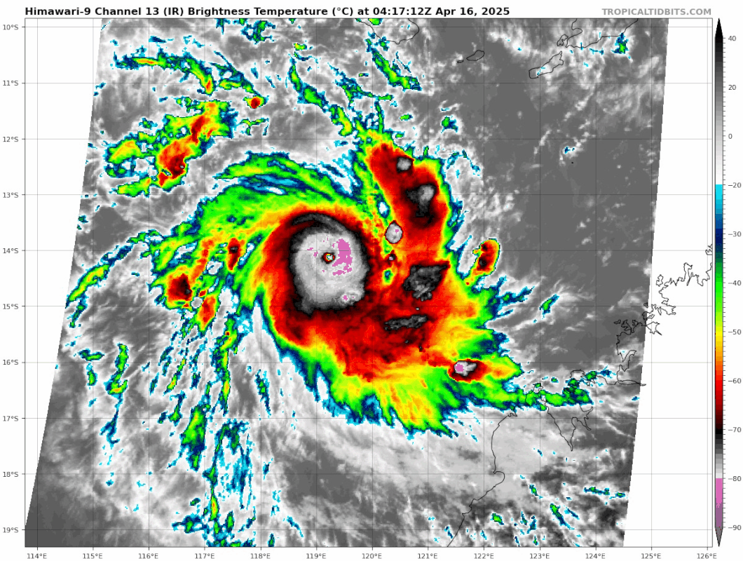
Thick CMG ring, WMG pixels in eye. I’m no Dvorak expert, but I even feel like placing this at 100 kts would be a bit on the conservative side.

3 likes
I am NOT a professional meteorologist, so take all of my posts with a grain of salt. My opinions are mine and mine alone.
-
cycloneye
- Admin
- Posts: 149276
- Age: 69
- Joined: Thu Oct 10, 2002 10:54 am
- Location: San Juan, Puerto Rico
Re: SIO: ERROL - Tropical Cyclone
TROPICAL CYCLONE INFORMATION BULLETIN
Issued at 8:33 am WST on Wednesday 16 April 2025
Tropical Cyclone Errol (Category 2) was located at 8:00 am AWST near 14.0S
119.8E, that is 515 km north northwest of Broome and 540 km west northwest of
Kuri Bay, and was moving west southwest at 10 kilometres per hour.
Tropical Cyclone Errol is expected to continue intensifying to reach a severe
category 3 tropical cyclone later today.
Errol is currently moving west, but is expected to turn to the southeast from
tonight and begin moving towards the west Kimberley coast on Thursday.
Errol may weaken to a category 1 cyclone as it approaches the coast late on
Friday. Despite the weakening, gales may still occur along exposed parts of the
coast overnight on Friday or early Saturday.
Impacts associated with tropical cyclone Errol are not expected along coast
within the next 48 hours.
1 likes
Visit the Caribbean-Central America Weather Thread where you can find at first post web cams,radars
and observations from Caribbean basin members Click Here
and observations from Caribbean basin members Click Here
-
WaveBreaking
- Category 2
- Posts: 717
- Joined: Sun Jun 30, 2024 11:33 am
- Location: US
Re: SIO: ERROL - Tropical Cyclone

4 likes
I am NOT a professional meteorologist, so take all of my posts with a grain of salt. My opinions are mine and mine alone.
Re: SIO: ERROL - Tropical Cyclone
Between the manual Dvorak fix of 6.0 at 230z and the last few raw ADT numbers (6.2, 6.1, 6.0) it's quite possible that Errol is already nearing its forecast peak intensity of 120kt. It may be approaching a pleateau now, but this has been a rather impressive run of rapid intensification, and conditions aren't expected to become unfavourable for 12+ hours yet.
0 likes
Re: SIO: ERROL - Tropical Cyclone


6 likes
TC naming lists: retirements and intensity
Most aggressive Advisory #1's in North Atlantic (cr. kevin for starting the list)
Most aggressive Advisory #1's in North Atlantic (cr. kevin for starting the list)

Re: SIO: ERROL - Severe Tropical Cyclone
With these cases of ERI and (near-)pinhole eyes, Dvorak often lags behind the true intensity. We for example saw this with Milton last year when during its initial ERI Dvorak was only at 4.7 - 5.2 (80 - 95 kt) while the true intensity of 120 kt at 1200 UTC / Oct 7 was much closer to the raw T# 6.2 - 6.6 (120 - 130 kt).
As such I'd also strongly favor increased reliance on raw T# in combination with visual confirmation for the current intensity of Errol. Raw T# are currently at 6.5, which makes me believe that Errol's intensity is close to that of Milton during the timestamp I mentioned above. Comparing satellite images of Milton and Errol also shows a similar visual structure with Errol being even 'cleaner' at this stage around the eye. As such I'd put the current intensity at 115 - 125 kt.
As such I'd also strongly favor increased reliance on raw T# in combination with visual confirmation for the current intensity of Errol. Raw T# are currently at 6.5, which makes me believe that Errol's intensity is close to that of Milton during the timestamp I mentioned above. Comparing satellite images of Milton and Errol also shows a similar visual structure with Errol being even 'cleaner' at this stage around the eye. As such I'd put the current intensity at 115 - 125 kt.
3 likes
Re: SIO: ERROL - Severe Tropical Cyclone
CDO rapidly cooling, average CDO temperature is now down to -77C, raw T# up to 6.6.
1 likes
-
cycloneye
- Admin
- Posts: 149276
- Age: 69
- Joined: Thu Oct 10, 2002 10:54 am
- Location: San Juan, Puerto Rico
Re: SIO: ERROL - Severe Tropical Cyclone
Perfect.

2 likes
Visit the Caribbean-Central America Weather Thread where you can find at first post web cams,radars
and observations from Caribbean basin members Click Here
and observations from Caribbean basin members Click Here
-
cycloneye
- Admin
- Posts: 149276
- Age: 69
- Joined: Thu Oct 10, 2002 10:54 am
- Location: San Juan, Puerto Rico
Re: SIO: ERROL - Severe Tropical Cyclone
REMARKS:
Severe Tropical Cyclone Errol has developed into a category 3 cyclone
displaying an eye. Position is based on animated satellite and rapidscan VIS
imagery with good confidence.
Intensity 80 kn based on Dvorak analysis. Dvorak analysis: DT is 6.5 based on
eye pattern W surrounding and OW/WMG eye temp. MET is 4.0 and PT 4.5. FT and
CI=5.0 are constrained. Objective aids have started catching up with the rapid
development. Objective intensity estimates (1-minute average) at 0600UTC: ADT
92 kn, AiDT 98 kn, DPRINT 91 kn and SATCON 74 kn (0340 UTC).
Environmental conditions are favourable for further development. Sea surface
temperatures are near 30C along the forecast track, and deep layer moisture is
in place around the system. Errol lies along the axis of an upper level
anticyclone and CIMSS analysed deep layer wind shear is 8 kn from the
northeast.
A shortwave upper trough over Western Australia is enhancing poleward outflow
somewhat and there is reasonable upper divergence analysed to the south of the
circulation. Further development is forecast in the next 12 to 24 h to a peak
of 100 kn (category 4) by Thursday morning. Being a small system, Errol is
expected to react quickly to the change in environmental conditions from late
Thursday as it gets influenced by increasing wind shear and dry air intrusion.
Hence, Errol is forecast to weaken to category 1 or even below tropical cyclone
strength as it approaches the west Kimberley coast on Saturday.
The system is expected to begin recurving towards the southeast tonight as the
influence of a mid-level ridge to the south weakens. An amplifying upper trough
over southwest WA is expected to steer the system southeast from Thursday,
towards the west Kimberley coast. The depth and intensity of Errol hasn t been
captured fully by the deterministic model runs. As a result, there is large
uncertainty in its movement along its track. On its current forecast, Errol is
expected to make landfall as a tropical low near Cape Leveque on Saturday
afternoon.
0 likes
Visit the Caribbean-Central America Weather Thread where you can find at first post web cams,radars
and observations from Caribbean basin members Click Here
and observations from Caribbean basin members Click Here
-
Hurricane2022
- Category 5
- Posts: 2016
- Joined: Tue Aug 23, 2022 11:38 pm
- Location: Araçatuba, Brazil
Re: SIO: ERROL - Severe Tropical Cyclone
Per MW imagery, Errol really did a very brief ERC. I hope he can clear his new and beautiful eye before shear kicks in.
1 likes
Sorry for the bad English sometimes...!
For reliable and detailed information for any meteorological phenomenon, please consult the National Hurricane Center, Joint Typhoon Warning Center , or your local Meteo Center.
--------
ECCE OMNIA NOVA FACIAM (Ap 21,5).
For reliable and detailed information for any meteorological phenomenon, please consult the National Hurricane Center, Joint Typhoon Warning Center , or your local Meteo Center.
--------
ECCE OMNIA NOVA FACIAM (Ap 21,5).
-
Hurricane2022
- Category 5
- Posts: 2016
- Joined: Tue Aug 23, 2022 11:38 pm
- Location: Araçatuba, Brazil
Re: SIO: ERROL - Severe Tropical Cyclone
https://x.com/JavaHurricane/status/1912376953602216055
https://x.com/zeb199818/status/1912419341007794314
https://x.com/zeb199818/status/1912397624503857565
https://x.com/JavaHurricane/status/1912376953602216055
https://x.com/zeb199818/status/1912419341007794314
https://x.com/zeb199818/status/1912397624503857565
https://x.com/JavaHurricane/status/1912376953602216055
2 likes
Sorry for the bad English sometimes...!
For reliable and detailed information for any meteorological phenomenon, please consult the National Hurricane Center, Joint Typhoon Warning Center , or your local Meteo Center.
--------
ECCE OMNIA NOVA FACIAM (Ap 21,5).
For reliable and detailed information for any meteorological phenomenon, please consult the National Hurricane Center, Joint Typhoon Warning Center , or your local Meteo Center.
--------
ECCE OMNIA NOVA FACIAM (Ap 21,5).
-
cycloneye
- Admin
- Posts: 149276
- Age: 69
- Joined: Thu Oct 10, 2002 10:54 am
- Location: San Juan, Puerto Rico
Re: SIO: ERROL - Severe Tropical Cyclone
Not that 865 mb cyclone but agree that HAFS nailed it.
https://x.com/AndyHazelton/status/1912462625025249518
https://x.com/AndyHazelton/status/1912462625025249518
2 likes
Visit the Caribbean-Central America Weather Thread where you can find at first post web cams,radars
and observations from Caribbean basin members Click Here
and observations from Caribbean basin members Click Here
-
Hurricane2022
- Category 5
- Posts: 2016
- Joined: Tue Aug 23, 2022 11:38 pm
- Location: Araçatuba, Brazil
Re: SIO: ERROL - Severe Tropical Cyclone
ALL HAIL HIS MAJESTY KING HAFS-A THE FIRST!!!


Last edited by Hurricane2022 on Wed Apr 16, 2025 6:34 am, edited 1 time in total.
0 likes
Sorry for the bad English sometimes...!
For reliable and detailed information for any meteorological phenomenon, please consult the National Hurricane Center, Joint Typhoon Warning Center , or your local Meteo Center.
--------
ECCE OMNIA NOVA FACIAM (Ap 21,5).
For reliable and detailed information for any meteorological phenomenon, please consult the National Hurricane Center, Joint Typhoon Warning Center , or your local Meteo Center.
--------
ECCE OMNIA NOVA FACIAM (Ap 21,5).
Who is online
Users browsing this forum: No registered users and 117 guests