Texas Spring 2025

U.S. & Caribbean Weather Discussions and Severe Weather Events

Moderator: S2k Moderators

Forum rules

The posts in this forum are NOT official forecast and should not be used as such. They are just the opinion of the poster and may or may not be backed by sound meteorological data. They are NOT endorsed by any professional institution or STORM2K.

Help Support Storm2K
Message
Author
Brent
S2K Supporter
S2K Supporter
Posts: 38089
Age: 36
Joined: Sun May 16, 2004 10:30 pm
Location: Tulsa Oklahoma
Contact:

Re: Texas Spring 2025

#1141 Postby Brent » Wed May 14, 2025 7:07 am

wxman22 wrote:Bears watching.

https://i.ibb.co/1GvcwMd6/image-full4.png


Yeah if we get another Monday outbreak :eek:

Both the historic Moore tornadoes were on a Monday :spam:
0 likes   
#neversummer

User avatar
wxman22
Category 5
Category 5
Posts: 1492
Joined: Mon Jan 30, 2006 12:39 am
Location: Wichita Falls, TX
Contact:

Re: Texas Spring 2025

#1142 Postby wxman22 » Wed May 14, 2025 7:38 am

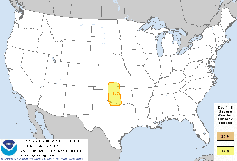
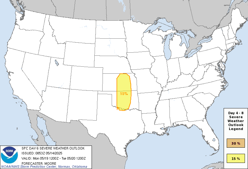
Severe weather risk posted from Kansas to the Red River counties. Expect changes or expansion of these outlook areas as confidence increases per SPC. Based on the current models I wouldn’t be surprised to see an expansion south into the DFW area also. Looks like a potentially high end dryline setup.

Image

Image


Day 4-8 Convective Outlook
NWS Storm Prediction Center Norman OK
0353 AM CDT Wed May 14 2025

Valid 171200Z - 221200Z

...DISCUSSION...
An active period of severe weather remains likely through the
weekend and into early next week for portions of the central CONUS.
A weakening upper trough is forecast to migrate across the Northeast
late this weekend as a second upper wave begins to amplify over the
western states. This upper regime will favor surface pressure falls
across the High Plains that will promote south/southeasterly return
flow into the southern/central Plains through early next week.
Severe thunderstorm chances will increase as preceding upper
disturbances and the primary upper wave eject into the Plains over
the warm sector. While severe weather chances are anticipated most
days through the extended period, confidence in more focused,
synoptically-driven corridors is currently greatest on D5/Sunday and
D6/Monday across the southern Plains.

...D5/Sunday to D6/Monday...
Increasing southwesterly flow aloft over the southern/central
Rockies will promote lee cyclogenesis across the central High Plains
beginning D4/Saturday through D7/Monday. This will foster moisture
return into northern TX, OK, and southern KS as a warm front lifts
north. Long-range ensemble guidance suggests dewpoints ranging from
the mid 60s to low 70s are likely by Sunday afternoon across the
southern High Plains to the east of a sharpening dryline. Recent
GFS/GEFS solutions have come into better alignment with ECMWF/EPS
runs that depict a leading impulse within the subtropical jet
overspreading the southern High Plains late Sunday afternoon.
Enhanced westerly low- to mid-level flow coupled with ascent
associated with the upper feature should promote eastward mixing of
the dryline with attendant chances for thunderstorm development
within a buoyant and strongly sheared environment.

The ejection of the primary trough axis on D6/Monday should result
in more widespread 50+ knot mid-level flow overspreading much of
OK/KS. The eastward migration of the surface low and trailing
dryline through the day should provide adequate forcing for ascent
for thunderstorm development within a buoyant and strongly sheared
environment, which should promote an organized, and potentially more
widespread, severe threat.

More specific mesoscale details for both days remain unclear at this
range, but the general alignment of global deterministic/ensemble
guidance regarding the overall synoptic regime and convective
environment, combined with a consistent QPF signal on both days,
suggests predictability is high enough to introduce risk
probabilities.
0 likes   

User avatar
wxman22
Category 5
Category 5
Posts: 1492
Joined: Mon Jan 30, 2006 12:39 am
Location: Wichita Falls, TX
Contact:

Re: Texas Spring 2025

#1143 Postby wxman22 » Wed May 14, 2025 8:15 am

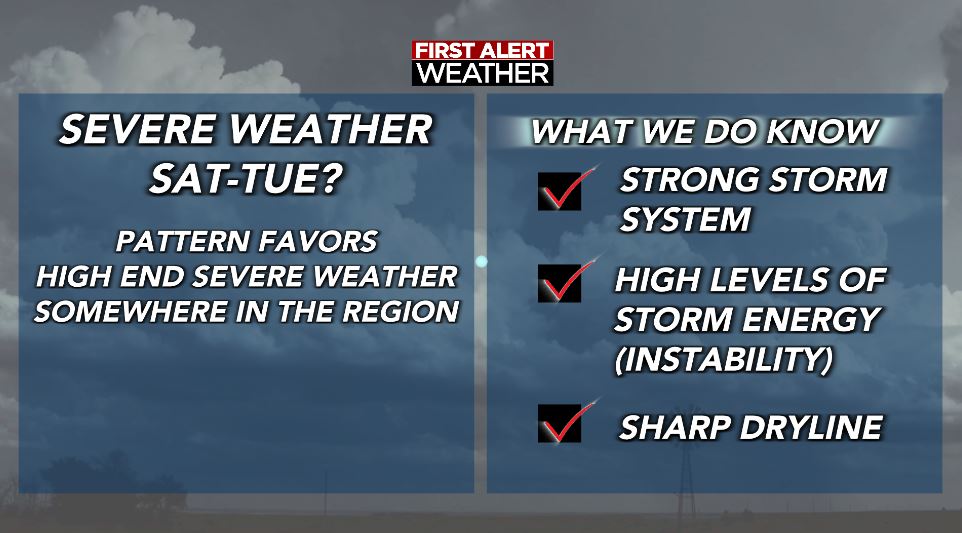
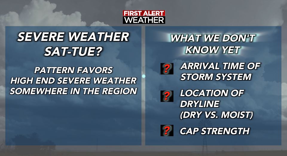
Posted this morning from Ken Johnson, one of the local chief mets in WF.

Image

Image
0 likes   

User avatar
Ntxw
Storm2k Moderator
Storm2k Moderator
Posts: 22785
Joined: Wed Oct 21, 2009 6:34 pm
Location: DFW, Texas

Re: Texas Spring 2025

#1144 Postby Ntxw » Wed May 14, 2025 10:10 am

Goes east imagery showing cloud cover streaming from the EPAC. This may put a lid in some areas from reach forecasted highs, I would think? It's warmer in DFW now than it is in Austin.
0 likes   
The above post and any post by Ntxw is NOT an official forecast and should not be used as such. It is just the opinion of the poster and may or may not be backed by sound meteorological data. It is NOT endorsed by any professional institution including Storm2k. For official information, please refer to NWS products.

  Help support Storm2K!
Help Support Storm2K

User avatar
Ntxw
Storm2k Moderator
Storm2k Moderator
Posts: 22785
Joined: Wed Oct 21, 2009 6:34 pm
Location: DFW, Texas

Re: Texas Spring 2025

#1145 Postby Ntxw » Wed May 14, 2025 2:00 pm

Cloud cover and higher dewpoints have kept temperatures from soaring today. Still hot, but not as high they were looking to be.

Image
0 likes   
The above post and any post by Ntxw is NOT an official forecast and should not be used as such. It is just the opinion of the poster and may or may not be backed by sound meteorological data. It is NOT endorsed by any professional institution including Storm2k. For official information, please refer to NWS products.


  Help support Storm2K!

Help Support Storm2K


rwfromkansas
Category 5
Category 5
Posts: 2627
Joined: Sat Aug 27, 2005 12:47 am
Location: North Fort Worth

Re: Texas Spring 2025

#1146 Postby rwfromkansas » Wed May 14, 2025 2:21 pm

My home station literally peaked at 99.9. Not joking. It's down to 97.5, so I think we may avoid the first 100 IMBY.

That is crazy how close it got.
0 likes   

User avatar
Cpv17
Category 5
Category 5
Posts: 4978
Joined: Wed Dec 07, 2016 2:24 pm
Location: Wharton/El Campo, TX

Re: Texas Spring 2025

#1147 Postby Cpv17 » Wed May 14, 2025 2:52 pm

rwfromkansas wrote:My home station literally peaked at 99.9. Not joking. It's down to 97.5, so I think we may avoid the first 100 IMBY.

That is crazy how close it got.


Weird it peaked that early in the day.
1 likes   

rwfromkansas
Category 5
Category 5
Posts: 2627
Joined: Sat Aug 27, 2005 12:47 am
Location: North Fort Worth

Re: Texas Spring 2025

#1148 Postby rwfromkansas » Wed May 14, 2025 3:17 pm

Cpv17 wrote:
rwfromkansas wrote:My home station literally peaked at 99.9. Not joking. It's down to 97.5, so I think we may avoid the first 100 IMBY.

That is crazy how close it got.


Weird it peaked that early in the day.


Yeah, usually it's at 3-4 or so, so kind of strange. It is going back up again a little, so hopefully it stays below 100.
0 likes   

User avatar
Cpv17
Category 5
Category 5
Posts: 4978
Joined: Wed Dec 07, 2016 2:24 pm
Location: Wharton/El Campo, TX

Re: Texas Spring 2025

#1149 Postby Cpv17 » Wed May 14, 2025 3:45 pm

rwfromkansas wrote:
Cpv17 wrote:
rwfromkansas wrote:My home station literally peaked at 99.9. Not joking. It's down to 97.5, so I think we may avoid the first 100 IMBY.

That is crazy how close it got.


Weird it peaked that early in the day.


Yeah, usually it's at 3-4 or so, so kind of strange. It is going back up again a little, so hopefully it stays below 100.


That’s not an issue for me. Only in the low 90’s here. Think being only one hour away from the Gulf and being away from a bunch of concrete helps me out.
0 likes   

Brent
S2K Supporter
S2K Supporter
Posts: 38089
Age: 36
Joined: Sun May 16, 2004 10:30 pm
Location: Tulsa Oklahoma
Contact:

Re: Texas Spring 2025

#1150 Postby Brent » Wed May 14, 2025 4:09 pm

Broke the record from 1911 here :spam:
0 likes   
#neversummer

Stratton23
Category 5
Category 5
Posts: 2519
Joined: Fri Jul 21, 2023 10:59 pm
Location: Katy, Tx

Re: Texas Spring 2025

#1151 Postby Stratton23 » Wed May 14, 2025 4:48 pm

Some signs that the heat ridge may try to retrogade back to the west and setup over the western US, that may take the worst of the heat away from texas, noaa still calls for above average precipitation across the state, i just dont buy it, im not really optimistic we are going to be seeing any decent rain chances even going into the longer range
0 likes   

DallasAg
Tropical Storm
Tropical Storm
Posts: 202
Joined: Sun Feb 14, 2021 11:20 am
Location: Dallas, TX

Re: Texas Spring 2025

#1152 Postby DallasAg » Wed May 14, 2025 5:06 pm

Ntxw wrote:Cloud cover and higher dewpoints have kept temperatures from soaring today. Still hot, but not as high they were looking to be.

https://i.imgur.com/ZLPSFM8.png

DFW even managed to avoid the record high for the date. Topped out at 94. Once the wind kicked back around to the south (from SW) and the dewpoints climbed it pretty much halted the temps.
0 likes   

User avatar
Edwards Limestone
S2K Supporter
S2K Supporter
Posts: 476
Age: 36
Joined: Tue Dec 28, 2021 11:05 am
Location: Smithson Valley, TX

Re: Texas Spring 2025

#1153 Postby Edwards Limestone » Wed May 14, 2025 5:12 pm

SAT just hit 101, heat index 105
0 likes   
The above post is NOT an official forecast and should not be used as such. It is just the opinion of the poster and may or may not be backed by sound meteorological data. It is NOT endorsed by any professional institution including Storm2k. For official information, please refer to NWS products.

User avatar
South Texas Storms
Professional-Met
Professional-Met
Posts: 4226
Joined: Thu Jun 24, 2010 12:28 am
Location: Houston, TX

Re: Texas Spring 2025

#1154 Postby South Texas Storms » Wed May 14, 2025 5:41 pm

DallasAg wrote:
Ntxw wrote:Cloud cover and higher dewpoints have kept temperatures from soaring today. Still hot, but not as high they were looking to be.

https://i.imgur.com/ZLPSFM8.png

DFW even managed to avoid the record high for the date. Topped out at 94. Once the wind kicked back around to the south (from SW) and the dewpoints climbed it pretty much halted the temps.


Congrats to us for only reaching the mid 90s to lower 100s today. In mid May...typically one of the wettest times of the year. This pattern sucks.
2 likes   

Pas_Bon
Tropical Depression
Tropical Depression
Posts: 73
Age: 45
Joined: Mon Jul 15, 2019 12:25 pm
Location: League City, TX

Re: Texas Spring 2025

#1155 Postby Pas_Bon » Wed May 14, 2025 5:45 pm

South Texas Storms wrote:
DallasAg wrote:
Ntxw wrote:Cloud cover and higher dewpoints have kept temperatures from soaring today. Still hot, but not as high they were looking to be.

https://i.imgur.com/ZLPSFM8.png

DFW even managed to avoid the record high for the date. Topped out at 94. Once the wind kicked back around to the south (from SW) and the dewpoints climbed it pretty much halted the temps.


Congrats to us for only reaching the mid 90s to lower 100s today. In mid May...typically one of the wettest times of the year. This pattern sucks.


I made confetti, but it vaporized and turned to ash.
2 likes   

cstrunk
Category 2
Category 2
Posts: 635
Joined: Sat Jul 04, 2020 10:38 am
Location: Longview, TX

Re: Texas Spring 2025

#1156 Postby cstrunk » Wed May 14, 2025 6:00 pm

The 95/96F forecast high for Longview busted. 89F was the max.
1 likes   

rwfromkansas
Category 5
Category 5
Posts: 2627
Joined: Sat Aug 27, 2005 12:47 am
Location: North Fort Worth

Re: Texas Spring 2025

#1157 Postby rwfromkansas » Wed May 14, 2025 7:23 pm

Temps never bust low in Texas so I will take it.
0 likes   

gpsnowman
S2K Supporter
S2K Supporter
Posts: 3185
Joined: Fri Jan 07, 2011 10:35 am
Location: Grand Prairie Tx

Re: Texas Spring 2025

#1158 Postby gpsnowman » Wed May 14, 2025 7:31 pm

cstrunk wrote:The 95/96F forecast high for Longview busted. 89F was the max.

Love seeing the low busts around Texas. Won't last long and I'll see y'all in October. :cold:
1 likes   

User avatar
txtwister78
Category 5
Category 5
Posts: 1854
Joined: Wed Jan 30, 2019 12:56 pm
Location: San Antonio

Re: Texas Spring 2025

#1159 Postby txtwister78 » Wed May 14, 2025 7:59 pm

Stratton23 wrote:Some signs that the heat ridge may try to retrogade back to the west and setup over the western US, that may take the worst of the heat away from texas, noaa still calls for above average precipitation across the state, i just dont buy it, im not really optimistic we are going to be seeing any decent rain chances even going into the longer range


CPC's outlook is based on a '33-40%" chance of precip being slightly above normal so it's not exactly a slam dunk however as mentioned previously, models do show some isolated storms chances beginning Friday but especially on Saturday into early next week from the southern HC to north Texas.

Granted those chances won't be widespread, but because it will be tough to pinpoint where storms develop each day, a broad outline isn't all that surprising.

In other words, whoever gets lucky that specific area could get some above average rainfall especially with a slow moving supercell along the dryline.
1 likes   

Brent
S2K Supporter
S2K Supporter
Posts: 38089
Age: 36
Joined: Sun May 16, 2004 10:30 pm
Location: Tulsa Oklahoma
Contact:

Re: Texas Spring 2025

#1160 Postby Brent » Thu May 15, 2025 6:43 am

6am temperature is 76 degrees. Good grief :eek: :double: May all time record is 77 apparently

But yes I'm seeing the same thing about below normal temps next week which the average high is still 79 right now
0 likes   
#neversummer


Return to “USA & Caribbean Weather”

Who is online

Users browsing this forum: No registered users and 18 guests