2025 Global Model Runs Discussion (Out thru day 16)

This is the general tropical discussion area. Anyone can take their shot at predicting a storms path.

Moderator: S2k Moderators

Forum rules

The posts in this forum are NOT official forecasts and should not be used as such. They are just the opinion of the poster and may or may not be backed by sound meteorological data. They are NOT endorsed by any professional institution or STORM2K. For official information, please refer to products from the National Hurricane Center and National Weather Service.

Help Support Storm2K
Message
Author
DunedinDave
Tropical Storm
Tropical Storm
Posts: 227
Joined: Fri Aug 25, 2023 10:31 am

Re: 2025 Global Model Runs Discussion (Out thru day 16)

#61 Postby DunedinDave » Mon May 26, 2025 7:09 pm

Stratton23 wrote:Some hints on the 18z GFS of weak low pressure trying to consolidate somewhere near the yucatan channel around the 3-4th, not much though

Looks like it has it as a hurricane entering the southern Gulf at the end of its run.

That said, it is happy hour.
0 likes   

Stratton23
Category 5
Category 5
Posts: 2506
Joined: Fri Jul 21, 2023 10:59 pm
Location: Katy, Tx

Re: 2025 Global Model Runs Discussion (Out thru day 16)

#62 Postby Stratton23 » Mon May 26, 2025 11:40 pm

00z GFS still trying to develop a weak system in the yucatan channel at day 9
0 likes   

User avatar
Category5Kaiju
Category 5
Category 5
Posts: 4094
Joined: Thu Dec 24, 2020 12:45 pm
Location: Seattle

Re: 2025 Global Model Runs Discussion (Out thru day 16)

#63 Postby Category5Kaiju » Mon May 26, 2025 11:45 pm

GFS seems to like the idea of a CAG-born system by the first week of June.
1 likes   
Unless explicitly stated, all info in my posts is based on my own opinions and observations. Tropical storms and hurricanes can be extremely dangerous. Do not think you can beat Mother Nature. Refer to an accredited weather research agency or meteorologist if you need to make serious decisions regarding an approaching storm.

ChrisH-UK
Category 2
Category 2
Posts: 623
Joined: Sat May 29, 2021 8:22 am

Re: 2025 Global Model Runs Discussion (Out thru day 16)

#64 Postby ChrisH-UK » Tue May 27, 2025 7:02 am

The 00z run of ECWMF is now showing something. Something to keep a eye on over the next few days may be come a TC in the gulf or could well end up been a storm in the East Pacific rather the been a storm in the gulf if the usual west moving trend holds out.

Image
0 likes   

User avatar
Kingarabian
S2K Supporter
S2K Supporter
Posts: 15979
Joined: Sat Aug 08, 2009 3:06 am
Location: Honolulu, Hawaii

Re: 2025 Global Model Runs Discussion (Out thru day 16)

#65 Postby Kingarabian » Tue May 27, 2025 10:51 am

ChrisH-UK wrote:The 00z run of ECWMF is now showing something. Something to keep a eye on over the next few days may be come a TC in the gulf or could well end up been a storm in the East Pacific rather the been a storm in the gulf if the usual west moving trend holds out.

[url]https://imagizer.imageshack.com/img923/9345/5owJg2.gif [/url]

Long range Euro has been on and off the past 5 days in regards to this. Which gives the GFS some credibility.
0 likes   
RIP Kobe Bryant

AutoPenalti
Category 5
Category 5
Posts: 4030
Age: 29
Joined: Mon Aug 17, 2015 4:16 pm
Location: Ft. Lauderdale, Florida

Re: 2025 Global Model Runs Discussion (Out thru day 16)

#66 Postby AutoPenalti » Tue May 27, 2025 12:06 pm

Fantasy range GFS blows it up into a intensifying TC approaching the GOM/A
0 likes   
The posts in this forum are NOT official forecasts and should not be used as such. They are just the opinion of the poster and may or may not be backed by sound meteorological data. They are NOT endorsed by any professional institution or STORM2K. For official information, please refer to products from the NHC and NWS.


Model Runs Cheat Sheet:
GFS (5:30 AM/PM, 11:30 AM/PM)
HWRF, GFDL, UKMET, NAVGEM (6:30-8:00 AM/PM, 12:30-2:00 AM/PM)
ECMWF (1:45 AM/PM)

TCVN
is a weighted averaged

TomballEd
Category 2
Category 2
Posts: 683
Age: 61
Joined: Wed Aug 16, 2023 4:52 pm
Location: Spring/Klein area, not Tomball

Re: 2025 Global Model Runs Discussion (Out thru day 16)

#67 Postby TomballEd » Tue May 27, 2025 12:46 pm

The GFS system is not the same as the Euro system from what I see. GFS is from the CAG, the Euro looks to be forming off the tail end of a trough.

Maybe I'm wrong, the few Euro ensemble models that pick up on this seem to start down in Central America.
0 likes   

User avatar
cycloneye
Admin
Admin
Posts: 145238
Age: 68
Joined: Thu Oct 10, 2002 10:54 am
Location: San Juan, Puerto Rico

Re: 2025 Global Model Runs Discussion (Out thru day 16)

#68 Postby cycloneye » Tue May 27, 2025 1:06 pm

0 likes   
Visit the Caribbean-Central America Weather Thread where you can find at first post web cams,radars
and observations from Caribbean basin members Click Here

User avatar
Steve
S2K Supporter
S2K Supporter
Posts: 9617
Joined: Sat Apr 05, 2003 11:41 pm
Location: Not a state-caster

Re: 2025 Global Model Runs Discussion (Out thru day 16)

#69 Postby Steve » Tue May 27, 2025 1:21 pm

TomballEd wrote:The GFS system is not the same as the Euro system from what I see. GFS is from the CAG, the Euro looks to be forming off the tail end of a trough.

Maybe I'm wrong, the few Euro ensemble models that pick up on this seem to start down in Central America.


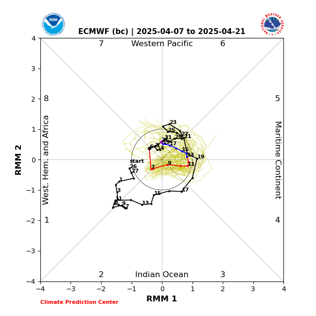
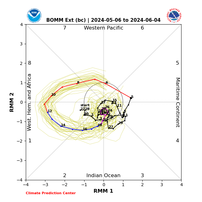
Looks like each of them (maybe more so the EC) leave a piece of a trough back that is what gets going (presumably in conjunction with the CAG).

The EC and Australian bias-corrected look the most likely for MJO to swing over through 8.

EC
Image

BOMM
Image
1 likes   

Stratton23
Category 5
Category 5
Posts: 2506
Joined: Fri Jul 21, 2023 10:59 pm
Location: Katy, Tx

Re: 2025 Global Model Runs Discussion (Out thru day 16)

#70 Postby Stratton23 » Tue May 27, 2025 6:24 pm

18z GFS continues its shenanigans lol, but i am becoming more interested in the 7-10th time frame
0 likes   

BobHarlem
Category 5
Category 5
Posts: 2090
Joined: Thu Oct 20, 2005 6:11 pm

Re: 2025 Global Model Runs Discussion (Out thru day 16)

#71 Postby BobHarlem » Wed May 28, 2025 9:35 am

6z GFS and 0z Euro both hinting at something in the Eastern Gulf June 10-12 (Early season slop)
0 likes   

TomballEd
Category 2
Category 2
Posts: 683
Age: 61
Joined: Wed Aug 16, 2023 4:52 pm
Location: Spring/Klein area, not Tomball

Re: 2025 Global Model Runs Discussion (Out thru day 16)

#72 Postby TomballEd » Wed May 28, 2025 10:28 am

~20% EPS members like something in the Gulf ~June 10. Or about 80% don't. I'm glass 1/5th full optimistic. Ensemble mean PWAT looks dry, probably why ~80% of the 0Z members are not impressed.
0 likes   

BobHarlem
Category 5
Category 5
Posts: 2090
Joined: Thu Oct 20, 2005 6:11 pm

Re: 2025 Global Model Runs Discussion (Out thru day 16)

#73 Postby BobHarlem » Thu May 29, 2025 12:40 pm

12z gfs is a bit for June. First one of these this season, but it's been fairly persistent for the last several runs on something happening around here (Gulf to Atl on Ensembles)
Starts south of Cuba in the West Caribbean around a week from Saturday. I guess we could start June 1st with a lemon. !2z euro doesn't really show anything this time, after hinting at something before. I'd probably go for that instead.

Image

Image
1 likes   

User avatar
Teban54
Category 5
Category 5
Posts: 3204
Joined: Sat May 19, 2018 1:19 pm

Re: 2025 Global Model Runs Discussion (Out thru day 16)

#74 Postby Teban54 » Thu May 29, 2025 3:47 pm

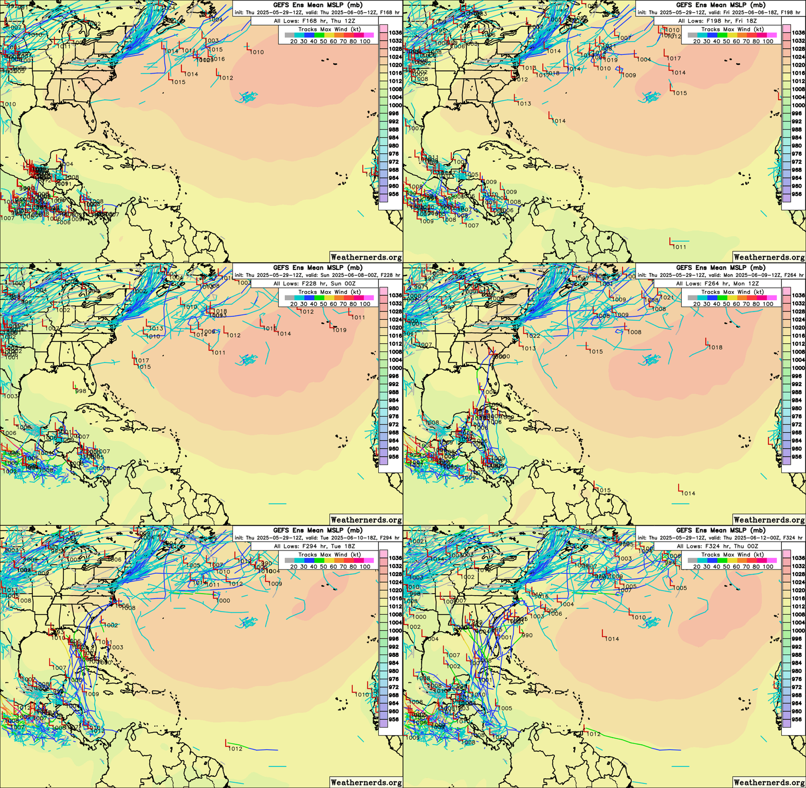
Significant increase on 12z GEFS for the Western Caribbean / Gulf system in the 8-10 days time frame, compared to earlier runs.

The Euro ensembles show a few lows, but are largely unenthusiastic. Let's see if this sticks on the GEFS.

Image
1 likes   

floridasun
Tropical Storm
Tropical Storm
Posts: 200
Joined: Tue Sep 14, 2021 3:59 pm

Re: 2025 Global Model Runs Discussion (Out thru day 16)

#75 Postby floridasun » Thu May 29, 2025 3:54 pm

gfs shot out system before june 1 but i hear only one doing it now other days their was few models show it in gulf
0 likes   

TomballEd
Category 2
Category 2
Posts: 683
Age: 61
Joined: Wed Aug 16, 2023 4:52 pm
Location: Spring/Klein area, not Tomball

Re: 2025 Global Model Runs Discussion (Out thru day 16)

#76 Postby TomballEd » Thu May 29, 2025 4:11 pm

Teban54 wrote:Significant increase on 12z GEFS for the Western Caribbean / Gulf system in the 8-10 days time frame, compared to earlier runs.

The Euro ensembles show a few lows, but are largely unenthusiastic. Let's see if this sticks on the GEFS.

https://i.postimg.cc/Y0Wp7Ynw/43504624.gif


If what I heard about the GFS and its enthusiasm for generating TCs in the W. Carib hasn't changed from a met now at NHC hasn't changed in ~10 years, the GFS uses a simplifying assumption that latent heat from convection only travels vertically, then the GFS ensembles may be too enthusiastic in generating TCs from persistent convection. I believe, unlike the Euro ensembles, which now have the same resolution as the op, the GFS ensembles are lower resolution than the operational model. But even if only a few ECENS show it, it can't be ruled out.

The lonely Euro ensemble member with a 989 mb high end TS/low end hurricane hitting near Cameron, LA week from Sunday is interesting.
1 likes   

User avatar
AtlanticWind
S2K Supporter
S2K Supporter
Posts: 1887
Age: 66
Joined: Sun Aug 08, 2004 9:57 pm
Location: Plantation,Fla

Re: 2025 Global Model Runs Discussion (Out thru day 16)

#77 Postby AtlanticWind » Thu May 29, 2025 7:05 pm

18Z GFS has a tropical storm in the Carribean in about 9 days and then
lifting north into Florida thereafter.
1 likes   

User avatar
Category5Kaiju
Category 5
Category 5
Posts: 4094
Joined: Thu Dec 24, 2020 12:45 pm
Location: Seattle

Re: 2025 Global Model Runs Discussion (Out thru day 16)

#78 Postby Category5Kaiju » Thu May 29, 2025 11:44 pm

GFS at this point seems pretty excited about the idea of a CAG generating two storms, one in the EPAC and one in the Atlantic.

*Ok, so I'm fairly sure that something remotely like this isn't going to happen. But, if you live in Louisiana, feel free to not look at the last GFS run. That run really apparently hates the state.*
1 likes   
Unless explicitly stated, all info in my posts is based on my own opinions and observations. Tropical storms and hurricanes can be extremely dangerous. Do not think you can beat Mother Nature. Refer to an accredited weather research agency or meteorologist if you need to make serious decisions regarding an approaching storm.

Stratton23
Category 5
Category 5
Posts: 2506
Joined: Fri Jul 21, 2023 10:59 pm
Location: Katy, Tx

Re: 2025 Global Model Runs Discussion (Out thru day 16)

#79 Postby Stratton23 » Fri May 30, 2025 12:51 am

Not seeing any support from the Euro/ CMC guidance, GFS looks like its doing its typical model bias with pulling phantom energy up out of SA and trying to spin it up into something, I dont buy it
0 likes   

User avatar
jfk08c
S2K Supporter
S2K Supporter
Posts: 204
Joined: Mon Jun 11, 2018 4:36 pm
Location: Lakeland, FL

Re: 2025 Global Model Runs Discussion (Out thru day 16)

#80 Postby jfk08c » Fri May 30, 2025 5:51 am

Stratton23 wrote:Not seeing any support from the Euro/ CMC guidance, GFS looks like its doing its typical model bias with pulling phantom energy up out of SA and trying to spin it up into something, I dont buy it


Euro ensembles have a pretty decent signal on the 0z run. Granted, it's the first run of the Euro we have seen this but worth keeping an eye on
0 likes   


Return to “Talkin' Tropics”

Who is online

Users browsing this forum: Ulf and 15 guests