ATL: INVEST 93L - Discussion

Current storms and invests:

Moderators: hurricanetrack, S2k Moderators


The posts in this forum are NOT official forecasts and should not be used as such. They are just the opinion of the poster and may or may not be backed by sound meteorological data. They are NOT endorsed by any professional institution or STORM2K. For official information, please refer to products from the National Hurricane Center and National Weather Service.

Help Support Storm2K
Message
Author
User avatar
cycloneye
Admin
Admin
Posts: 145232
Age: 68
Joined: Thu Oct 10, 2002 10:54 am
Location: San Juan, Puerto Rico

ATL: INVEST 93L - Discussion

#1 Postby cycloneye » Mon Jul 14, 2025 12:46 pm

AL, 93, 2025071418, , BEST, 0, 296N, 780W, 20, 1016, DB, 34, NEQ, 0, 0, 0, 0, 1017, 100, 60, 0, 0, L, 0, , 0, 0, INVEST, S, 0, , 0, 0, 0, 0, genesis-num, 008, SPAWNINVEST, al772025 to al932025,


https://ftp.nhc.noaa.gov/atcf/btk/bal932025.dat

Image

Image
5 likes   
Visit the Caribbean-Central America Weather Thread where you can find at first post web cams,radars
and observations from Caribbean basin members Click Here

Stratton23
Category 5
Category 5
Posts: 2506
Joined: Fri Jul 21, 2023 10:59 pm
Location: Katy, Tx

Re: ATL: INVEST 93L - Discussion

#2 Postby Stratton23 » Mon Jul 14, 2025 12:55 pm

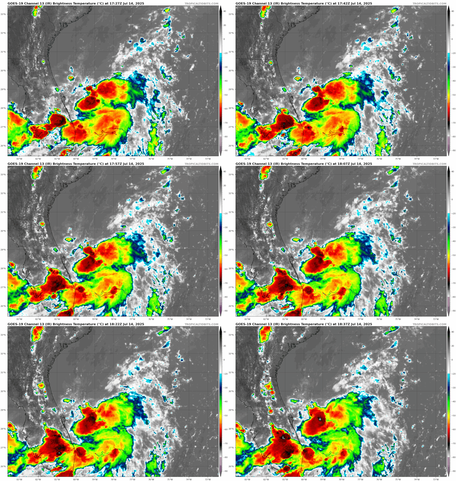
I see what looks to be a MLC to the east of palm bay, more convection focused in that area, might be an area to watch for consolidation of a new center, if thats the case that would be further south than even the ICON suggests
0 likes   

BobHarlem
Category 5
Category 5
Posts: 2090
Joined: Thu Oct 20, 2005 6:11 pm

Re: ATL: INVEST 93L - Discussion

#3 Postby BobHarlem » Mon Jul 14, 2025 12:57 pm

Image
Last edited by BobHarlem on Mon Jul 14, 2025 1:04 pm, edited 2 times in total.
3 likes   

TallyTracker
Category 2
Category 2
Posts: 732
Joined: Thu Oct 11, 2018 2:46 pm

Re: ATL: INVEST 93L - Discussion

#4 Postby TallyTracker » Mon Jul 14, 2025 1:00 pm

Just looking at the overall environment and current condition of the disturbance in marginal conditions, I think the development potential is much higher than 30%. The models don’t seem to have a good grasp on this one. I’d say it’s got at least a 50% chance of development. Even the NHC is saying conditions look favorable for development despite the 30%. The ICON’s prediction of a TS to Cat 1 Hurricane seems a reasonable outcome.
2 likes   
Fran '96, Georges '98, Gordon '00, Gabrielle '01, Charley '04, Frances '04, Jeanne '04, Barry '07, Fay '08, Debby '12, Matthew '16, Emily '17, Irma '17, Michael ‘18, Elsa ‘21, Fred ‘21, Mindy ‘21, Nicole ‘22, Idalia ‘23, Debby ‘24, Helene ‘24

BobHarlem
Category 5
Category 5
Posts: 2090
Joined: Thu Oct 20, 2005 6:11 pm

Re: ATL: INVEST 93L - Discussion

#5 Postby BobHarlem » Mon Jul 14, 2025 1:13 pm

PTC or TD first? (or neither or jump to Dexter)
0 likes   

User avatar
cycloneye
Admin
Admin
Posts: 145232
Age: 68
Joined: Thu Oct 10, 2002 10:54 am
Location: San Juan, Puerto Rico

Re: ATL: INVEST 93L - Discussion

#6 Postby cycloneye » Mon Jul 14, 2025 1:15 pm

BobHarlem wrote:PTC or TD first? (or neither or jump to Dexter)


It depends on what recon finds in terms of organization and intensity.
1 likes   
Visit the Caribbean-Central America Weather Thread where you can find at first post web cams,radars
and observations from Caribbean basin members Click Here

User avatar
Nimbus
Category 5
Category 5
Posts: 5298
Joined: Mon Jul 19, 2004 10:54 am

Re: ATL: INVEST 93L - Discussion

#7 Postby Nimbus » Mon Jul 14, 2025 1:21 pm

Stratton23 wrote:I see what looks to be a MLC to the east of palm bay, more convection focused in that area, might be an area to watch for consolidation of a new center, if thats the case that would be further south than even the ICON suggests


The northern apex of the visible circulation center is closer to the Cape Canaveral buoy where surface pressure was recently 1015.4 mb. surface pressure off Sebastian Inlet closer to 1014 mb. Probably defines a surface trough that may consolidate near the lowest surface pressure. Have to see what the models do with it but that was what I was seeing this morning before the visible imagery and NHC making it an invest off the east coast of Florida.
1 likes   

BobHarlem
Category 5
Category 5
Posts: 2090
Joined: Thu Oct 20, 2005 6:11 pm

Re: ATL: INVEST 93L - Discussion

#8 Postby BobHarlem » Mon Jul 14, 2025 1:26 pm

Banding starting to appear along in the Florida thunderstorms.

Image

I'd imagine with the evening stuff, it'll look a bit wild in a few spots in a few hours.
2 likes   

Sciencerocks
Category 5
Category 5
Posts: 9152
Age: 39
Joined: Thu Jul 06, 2017 1:51 am

Re: ATL: INVEST 93L - Discussion

#9 Postby Sciencerocks » Mon Jul 14, 2025 1:41 pm

Image

I'd go 70% in the next 2 days and this will possibly become a tropical storm before landfall on florida. Models are all over the place once in the gulf but if it does form into Dexter before florida landfall. Well, I think I'll remain Tropical storm Dexter to its second landfall and ICON becomes very much more likely.
5 likes   

User avatar
Woofde
Category 1
Category 1
Posts: 479
Joined: Tue Jul 06, 2021 11:33 am

Re: RE: Re: ATL: INVEST 93L - Discussion

#10 Postby Woofde » Mon Jul 14, 2025 1:47 pm

TallyTracker wrote:Just looking at the overall environment and current condition of the disturbance in marginal conditions, I think the development potential is much higher than 30%. The models don’t seem to have a good grasp on this one. I’d say it’s got at least a 50% chance of development. Even the NHC is saying conditions look favorable for development despite the 30%. The ICON’s prediction of a TS to Cat 1 Hurricane seems a reasonable outcome.
Haven't had the time to really dive into the details of this one, but I took a look at the floater imagery and 30% seem bearishly low. There's quite strong convection and some spiraling already present.
2 likes   

User avatar
cycloneye
Admin
Admin
Posts: 145232
Age: 68
Joined: Thu Oct 10, 2002 10:54 am
Location: San Juan, Puerto Rico

Re: ATL: INVEST 93L - Discussion

#11 Postby cycloneye » Mon Jul 14, 2025 1:56 pm

Image
2 likes   
Visit the Caribbean-Central America Weather Thread where you can find at first post web cams,radars
and observations from Caribbean basin members Click Here

User avatar
cycloneye
Admin
Admin
Posts: 145232
Age: 68
Joined: Thu Oct 10, 2002 10:54 am
Location: San Juan, Puerto Rico

Re: ATL: INVEST 93L - Discussion

#12 Postby cycloneye » Mon Jul 14, 2025 2:13 pm

0 likes   
Visit the Caribbean-Central America Weather Thread where you can find at first post web cams,radars
and observations from Caribbean basin members Click Here

User avatar
Ivanhater
Storm2k Moderator
Storm2k Moderator
Posts: 11159
Age: 38
Joined: Fri Jul 01, 2005 8:25 am
Location: Pensacola

Re: ATL: INVEST 93L - Discussion

#13 Postby Ivanhater » Mon Jul 14, 2025 2:16 pm

Banding is increasing. Not sure why they kept it at 30 percent. The good news, should have plenty of surface obs being close to shore
3 likes   
Michael

User avatar
cycloneye
Admin
Admin
Posts: 145232
Age: 68
Joined: Thu Oct 10, 2002 10:54 am
Location: San Juan, Puerto Rico

Re: ATL: INVEST 93L - Discussion

#14 Postby cycloneye » Mon Jul 14, 2025 2:20 pm

Maybe they do a STWO to upgrade the percentage?
1 likes   
Visit the Caribbean-Central America Weather Thread where you can find at first post web cams,radars
and observations from Caribbean basin members Click Here

BobHarlem
Category 5
Category 5
Posts: 2090
Joined: Thu Oct 20, 2005 6:11 pm

Re: ATL: INVEST 93L - Discussion

#15 Postby BobHarlem » Mon Jul 14, 2025 2:24 pm

Image
0 likes   

User avatar
cycloneye
Admin
Admin
Posts: 145232
Age: 68
Joined: Thu Oct 10, 2002 10:54 am
Location: San Juan, Puerto Rico

Re: ATL: INVEST 93L - Discussion

#16 Postby cycloneye » Mon Jul 14, 2025 2:30 pm

Josh is anxious to chase. :D Will he get a chance to do it?

 https://x.com/iCyclone/status/1944831880253030588

0 likes   
Visit the Caribbean-Central America Weather Thread where you can find at first post web cams,radars
and observations from Caribbean basin members Click Here

hurricane2025
Tropical Storm
Tropical Storm
Posts: 208
Joined: Thu Apr 08, 2021 10:36 am

Re: ATL: INVEST 93L - Discussion

#17 Postby hurricane2025 » Mon Jul 14, 2025 2:32 pm

Yeah models have done a bad job
0 likes   

TampaWxLurker
Tropical Depression
Tropical Depression
Posts: 99
Joined: Thu Aug 01, 2024 8:20 am

Re: ATL: INVEST 93L - Discussion

#18 Postby TampaWxLurker » Mon Jul 14, 2025 2:38 pm

Interesting spot/direction for cyclogenesis and supposed eventual movement. Homegrown systems from stalled fronts that end up moving west usually seem to form more often in the eastern Gulf. Stuff like this forming just off the east coast of FL (in my somewhat hazy memory) seem to generally move north/northeast. Hopefully it doesn't get too much time to develop before moving over us.

Looking at the SST's, it's right over the Gulf stream, in water currently at ~29.5° C, warm but not super hot. JUST to the west of where it is though is a relatively cool area of SST's, offshore of Canaveral and the Treasure Coast. SST's in the 26-28° C range. Will have to see if the blob continues due south over the warmer gulf stream or tracks closer to those cooler waters near the coast.
0 likes   

BobHarlem
Category 5
Category 5
Posts: 2090
Joined: Thu Oct 20, 2005 6:11 pm

Re: ATL: INVEST 93L - Discussion

#19 Postby BobHarlem » Mon Jul 14, 2025 2:40 pm

A little pop up tower or something due east of Cape Canaveral.
Image
0 likes   

User avatar
Steve
S2K Supporter
S2K Supporter
Posts: 9617
Joined: Sat Apr 05, 2003 11:41 pm
Location: Not a state-caster

Re: ATL: INVEST 93L - Discussion

#20 Postby Steve » Mon Jul 14, 2025 2:45 pm

Picture didn't come through, but it can't have an eyewall at this stage. It can have a center of circulation of course.
2 likes   


Return to “Active Storms/Invests - Atlantic/EastPAC/CentralPAC/MED”

Who is online

Users browsing this forum: Google Adsense [Bot] and 7 guests