Wave Over the North Central Gulf
Moderator: S2k Moderators
Forum rules
The posts in this forum are NOT official forecasts and should not be used as such. They are just the opinion of the poster and may or may not be backed by sound meteorological data. They are NOT endorsed by any professional institution or STORM2K. For official information, please refer to products from the National Hurricane Center and National Weather Service.
- ScottNAtlanta
- Category 5

- Posts: 2535
- Joined: Sat May 25, 2013 3:11 pm
- Location: Atlanta, GA
Wave Over the North Central Gulf
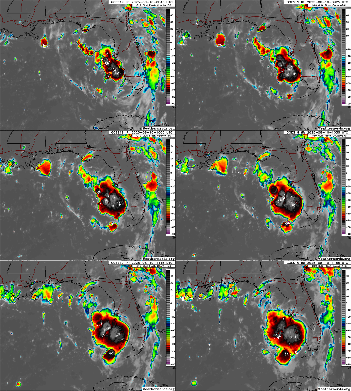
I've been watching this wave as it has been moving over the Atlantic and is now close to or over Florida. Yesterday there was a distinct wind shift between the east and west coast. Today the convection is really blowing up off the east coast. There doesn't seem to be much model support, but waves in this area with the amount of oceanic heat should always be watched, especially so close to the coast where things can unexpectedly spin up
0 likes
The posts in this forum are NOT official forecast and should not be used as such. They are just the opinion of the poster and may or may not be backed by sound meteorological data. They are NOT endorsed by any professional institution or storm2k.org. For official information, please refer to the NHC and NWS products.
Re: Wave Over Florida
I’ve been watching it too. Has a bit of a spin to it. Reminds me of ts Jerry in 95, though probably just a lot of rain.
2 likes
Re: Wave Over Florida
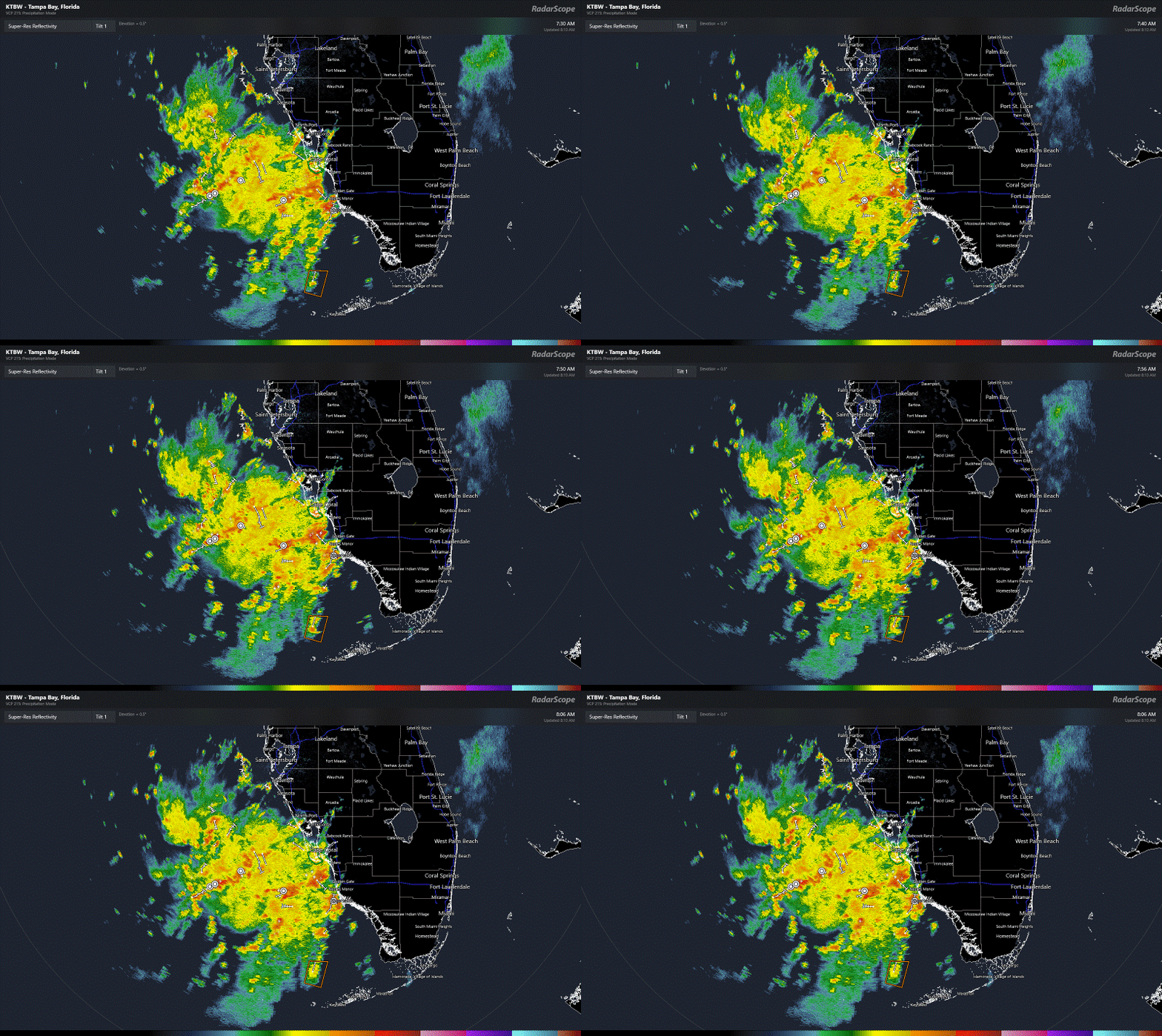
Definitely a rotation SW of Naples now in the GOM on radar. Can't tell if it's mid-level or at the surface.
0 likes
Re: Wave Along the SW Florida Coast
Gulf buoys are not showing any major surface pressure drops ~29.92.
Might be something small southeast of buoy 42001 which has been reporting winds from 20 degrees.
Might be something small southeast of buoy 42001 which has been reporting winds from 20 degrees.
0 likes
- stormhunter7
- Category 2

- Posts: 763
- Joined: Mon May 26, 2008 3:13 pm
- Location: Panama City Beach, Florida
- Contact:
Re: Wave Along the SW Florida Coast
Looks like a high has built over the top of this mid level low. Will it work down to the surface in SE Gulf???
1 likes
The following post is NOT an official forecast and should not be used as such. It is just the opinion of the poster and may or may not be backed by sound meteorological data. It is NOT endorsed by any professional institution including storm2k.org For Official Information please refer to the NHC and NWS products. http://www.nhc.noaa.gov
-
Tailgater33
- Tropical Depression

- Posts: 94
- Joined: Thu Jun 02, 2022 9:15 am
Re: Wave Along the SW Florida Coast
Yes it clearly has an upper high over top but any surface feature is weak and stretched out. Something to watch though, .97L is too far out to concern me
1 likes
- HurricaneBelle
- S2K Supporter

- Posts: 1209
- Joined: Sun Aug 27, 2006 6:12 pm
- Location: Clearwater, FL
Re: Wave Off the SW Florida Coast
Radar showing about 10" of rain around Sanibel from this system, quite an impressive display right now.
1 likes
Re: Wave Off the SW Florida Coast
Big blowup of convection off SW coast of FL this morning. Some hint of rotation. Upper level high overhead. Lowest pressure is bouy about 50 mi SW of Ft Myers at 29.95 which is reporting SW winds. Lowest air pressure from coastal stations at Sarasota and Placida.
1 likes
Re: Wave Off the SW Florida Coast
It shows decently (but not great) on the 850 vorticity charts


1 likes
Re: Wave Off the SW Florida Coast
Radar out of Key West is showing it starting to curl up to get a circulation and on satellite it looks to be blooming up. To me it has that look of a pop up storm with the waters nice and toastie.


0 likes
-
redingtonbeach
- Tropical Depression

- Posts: 65
- Joined: Mon Sep 04, 2017 12:05 am
Re: Wave Off the SW Florida Coast
Convection still expanding on VIS SAT. Definitely being aided by Upper level high overhead it. These home grown systems can sometimes surprise us. NWS Tampa indicating it's an inverted trough in their forecast discussions.
0 likes
- MississippiWx
- S2K Supporter

- Posts: 1720
- Joined: Sat Aug 14, 2010 1:44 pm
- Location: Hattiesburg, Mississippi
Re: Wave Off the SW Florida Coast
Zero model support for this. Not sure why because it has good convergence at the surface and upper level anticyclone over the top. Models apparently see something to make them unenthusiastic. Hopefully it will bring some much needed rain to my house.
1 likes
This post is not an official forecast and should not be used as such. It is just the opinion of MississippiWx and may or may not be backed by sound meteorological data. It is not endorsed by any professional institution including storm2k.org. For Official Information please refer to the NHC and NWS products.
- StormWeather
- Category 1

- Posts: 477
- Joined: Wed Jun 05, 2024 2:34 pm
Re: Wave Off the SW Florida Coast
MississippiWx wrote:Zero model support for this. Not sure why because it has good convergence at the surface and upper level anticyclone over the top. Models apparently see something to make them unenthusiastic. Hopefully it will bring some much needed rain to my house.
Have we ever had a TC form with no model support before?
0 likes
Just an average cyclone tracker
The posts in this forum are NOT official forecasts and should not be used as such. They are just the opinion of the poster and may or may not be backed by sound meteorological data. They are NOT endorsed by any professional institution or storm2k.org. For official information, please refer to the NHC and NWS products
The posts in this forum are NOT official forecasts and should not be used as such. They are just the opinion of the poster and may or may not be backed by sound meteorological data. They are NOT endorsed by any professional institution or storm2k.org. For official information, please refer to the NHC and NWS products
Re: Wave Off the SW Florida Coast
stormhunter7 wrote:Looks like a high has built over the top of this mid level low. Will it work down to the surface in SE Gulf???
Surface pressures were starting to drop in the area but have not dropped below 29.9 with background high pressure of ~30.07.
https://www.ndbc.noaa.gov/show_plot.php ... m=E&tz=CST
Lower shear at least from what we can see from the convection so maybe worth watching.
1 likes
- MississippiWx
- S2K Supporter

- Posts: 1720
- Joined: Sat Aug 14, 2010 1:44 pm
- Location: Hattiesburg, Mississippi
Re: Wave Off the SW Florida Coast
StormWeather wrote:MississippiWx wrote:Zero model support for this. Not sure why because it has good convergence at the surface and upper level anticyclone over the top. Models apparently see something to make them unenthusiastic. Hopefully it will bring some much needed rain to my house.
Have we ever had a TC form with no model support before?
I’m sure we have, but in today’s modern technology it would be quite the surprise. Not even mesoscale models spin it up into anything.
1 likes
This post is not an official forecast and should not be used as such. It is just the opinion of MississippiWx and may or may not be backed by sound meteorological data. It is not endorsed by any professional institution including storm2k.org. For Official Information please refer to the NHC and NWS products.
-
WeatherBoy2000
- Category 1

- Posts: 463
- Joined: Mon Apr 10, 2023 9:29 am
Re: Wave Off the SW Florida Coast
StormWeather wrote:MississippiWx wrote:Zero model support for this. Not sure why because it has good convergence at the surface and upper level anticyclone over the top. Models apparently see something to make them unenthusiastic. Hopefully it will bring some much needed rain to my house.
Have we ever had a TC form with no model support before?
Hurricane Oscar last year was pretty close. It had like a 10% chance of development with pretty much no model support until recon flew in to find a robust tropical storm on the verge of becoming a hurricane.
3 likes
- ScottNAtlanta
- Category 5

- Posts: 2535
- Joined: Sat May 25, 2013 3:11 pm
- Location: Atlanta, GA
Re: Wave Off the SW Florida Coast
If you look at the low level flow, it is starting to bend into the convection


1 likes
The posts in this forum are NOT official forecast and should not be used as such. They are just the opinion of the poster and may or may not be backed by sound meteorological data. They are NOT endorsed by any professional institution or storm2k.org. For official information, please refer to the NHC and NWS products.
Re: Wave Off the SW Florida Coast
StormWeather wrote:MississippiWx wrote:Zero model support for this. Not sure why because it has good convergence at the surface and upper level anticyclone over the top. Models apparently see something to make them unenthusiastic. Hopefully it will bring some much needed rain to my house.
Have we ever had a TC form with no model support before?
Its been off/on some ensembles. Part of this area was once 94l
1 likes
Who is online
Users browsing this forum: CyclonicFury, Iceresistance, Kingarabian and 157 guests

