
ATL: ERIN - Post-Tropical - Discussion
Moderator: S2k Moderators
-
Canelaw99

- S2K Supporter

- Posts: 2128
- Age: 49
- Joined: Tue Aug 31, 2004 8:27 am
- Location: Homestead, FL
Re: ATL: INVEST 97L - Discussion
cycloneye wrote:00z Best Track now moving WNW.AL, 97, 2025081100, , BEST, 0, 165N, 234W, 30, 1006, LO
https://i.imgur.com/wEbobpd.png
Do these waves usually gain that much latitude so quickly? I feel like I usually see them chugging west, maybe WNW, a bit longer.
2 likes
-
CrazyC83
- Professional-Met

- Posts: 34315
- Joined: Tue Mar 07, 2006 11:57 pm
- Location: Deep South, for the first time!
Re: ATL: INVEST 97L - Discussion
zzzh wrote:https://i.imgur.com/lymGUl1.png
With that wind barb and the low resolution, I'd go 35 kt for the initial intensity. If this was 24 hours ago, I'd classify it as TS Erin now to get the warnings out. But with the storm leaving the islands, there may be a bit of time to wait. If this trend continues, I'd start advisories early tomorrow (EDT), which I believe is 8 am CVT if 0900Z.
6 likes
-
cycloneye

- Admin

- Posts: 149463
- Age: 69
- Joined: Thu Oct 10, 2002 10:54 am
- Location: San Juan, Puerto Rico
Re: ATL: INVEST 97L - Discussion
Canelaw99 wrote:cycloneye wrote:00z Best Track now moving WNW.AL, 97, 2025081100, , BEST, 0, 165N, 234W, 30, 1006, LO
https://i.imgur.com/wEbobpd.png
Do these waves usually gain that much latitude so quickly? I feel like I usually see them chugging west, maybe WNW, a bit longer.
In this case, there was an upper trough near the Canary Islands that caused that not usual movement to the north.
3 likes
Visit the Caribbean-Central America Weather Thread where you can find at first post web cams,radars
and observations from Caribbean basin members Click Here
and observations from Caribbean basin members Click Here
-
Blown Away

- S2K Supporter
- Posts: 10253
- Joined: Wed May 26, 2004 6:17 am
Re: ATL: INVEST 97L - Discussion
I don’t believe many of the 18z models depicted this persistent convective ball. 97L appears to be on the S side of the ensemble spread.
4 likes
Hurricane Eye Experience: David 79, Irene 99, Frances 04, Jeanne 04, Wilma 05… Hurricane Brush Experience: Andrew 92, Erin 95, Floyd 99, Matthew 16, Irma 17, Ian 22, Nicole 22…


Re: ATL: INVEST 97L - Discussion

Center is embedded well within the deep convection if the station data is to be believed.
1 likes
-
Category5Kaiju

- Category 5

- Posts: 4333
- Joined: Thu Dec 24, 2020 12:45 pm
- Location: Seattle and Phoenix
Re: ATL: INVEST 97L - Discussion

Just a quick reminder that this is happening in 25-26 C waters. This demonstrates that while important, raw sea surface temperatures are only one aspect of the picture when it comes down to maintaining a tropical cyclone. The June-July chatter about this season struggling with stability in August, Atlantic Nina, lukewarm tropical sea surface temperatures, etc. now feels like ancient history.
6 likes
Unless explicitly stated, all info in my posts is based on my own opinions and observations. Tropical storms and hurricanes can be extremely dangerous. Refer to an accredited weather research agency or meteorologist if you need to make serious decisions regarding an approaching storm.

Re: ATL: INVEST 97L - Discussion
I think this is one of those systems that would already be classified if it weren't 1000+ miles away from the Caribbean and CONUS. Regardless, I expect the NHC to probably bump the 48 hour odds up to 70 or 80% in the next advisory, following with an upgrade at some point to TS Erin later in the day tomorrow (Aug 11th).
4 likes
-
ElectricStorm

- Category 5
- Posts: 5146
- Age: 25
- Joined: Tue Aug 13, 2019 11:23 pm
- Location: Norman, OK
Re: ATL: INVEST 97L - Discussion
Up to 70/90
1. Eastern Tropical Atlantic (AL97):
Showers and thunderstorms continue to show signs of organization
in association with a well-defined low pressure area located near
the northwestern Cabo Verde Islands. The system will likely become
a tropical depression within the next day or so while it moves
generally westward. Locally heavy rainfall and gusty winds are
expected to continue today across portions of the Cabo Verde
Islands, and interests there should monitor the progress of this
system.
Even if a tropical depression does not form over the next day or so,
environmental conditions appear conducive for later development, and
a tropical depression or tropical storm is expected to form by the
middle to latter portion of this week while moving westward to
west-northwestward at 15 to 20 mph across the eastern and central
tropical Atlantic.
* Formation chance through 48 hours...high...70 percent.
* Formation chance through 7 days...high...90 percent.
1 likes
B.S Meteorology, University of Oklahoma '25
Please refer to the NHC, NWS, or SPC for official information.
Please refer to the NHC, NWS, or SPC for official information.
-
WaveBreaking

- Category 2

- Posts: 722
- Joined: Sun Jun 30, 2024 11:33 am
- Location: US
Re: ATL: INVEST 97L - Discussion
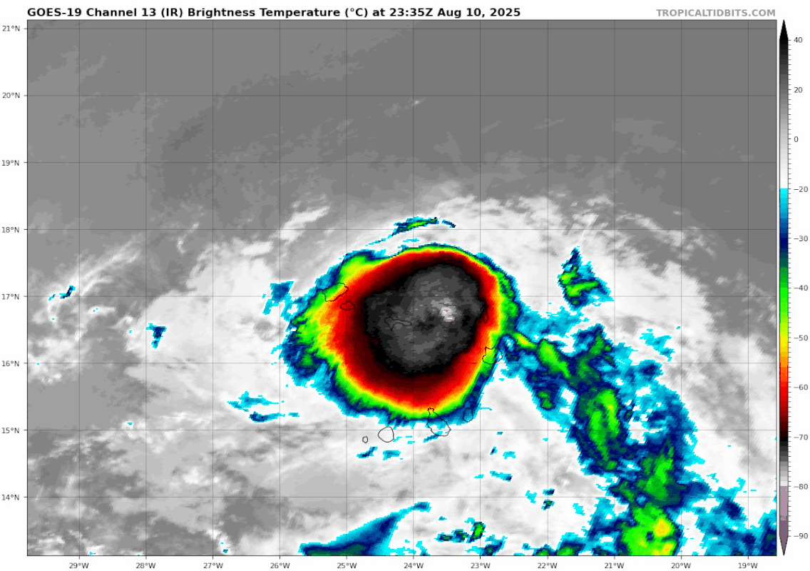
The edges of this proto-CDO are fanning out in nearly every direction. I wonder if this convection can sustain itself by sunrise.

1 likes
I am NOT a professional meteorologist, so take all of my posts with a grain of salt. My opinions are mine and mine alone.

Re: ATL: INVEST 97L - Discussion
From the latest (08.11/06z) Dvorak fix from NOAA/OSPO:
Deep convection has persisted for more than 12 hours now, and - as has been noted by meteorologists and other users here - ASCAT data suggests that there's a closed circulation. Surface observations from earlier this evening also suggest that that circulation is located under the cold overcast. It seems there just isn't enough confidence in that position yet for a tropical cyclone to be designated.
E. FIVE/GOES-E
F. T1.5/1.5
G. IR/EIR/SWIR
H. REMARKS...CIRCULARLY DEFINED CLOUD LINES LOCATED UNDER A LARGE COLD
OVERCAST YIELDS A DT OF 2.0. THE MET AND PT ARE 1.5 BASED ON THE INITIAL
DEVELOPMENT TREND WITHIN THE FIRST 24 HOURS. THE FT IS BASED ON THE MET
DUE TO UNCERTAINTY IN THE EXACT LLCC POSITION.
F. T1.5/1.5
G. IR/EIR/SWIR
H. REMARKS...CIRCULARLY DEFINED CLOUD LINES LOCATED UNDER A LARGE COLD
OVERCAST YIELDS A DT OF 2.0. THE MET AND PT ARE 1.5 BASED ON THE INITIAL
DEVELOPMENT TREND WITHIN THE FIRST 24 HOURS. THE FT IS BASED ON THE MET
DUE TO UNCERTAINTY IN THE EXACT LLCC POSITION.
Deep convection has persisted for more than 12 hours now, and - as has been noted by meteorologists and other users here - ASCAT data suggests that there's a closed circulation. Surface observations from earlier this evening also suggest that that circulation is located under the cold overcast. It seems there just isn't enough confidence in that position yet for a tropical cyclone to be designated.
4 likes
-
cycloneye
- Admin
- Posts: 149463
- Age: 69
- Joined: Thu Oct 10, 2002 10:54 am
- Location: San Juan, Puerto Rico
Re: ATL: INVEST 97L - Discussion
Looks like a TC and surely will be officially later today.

2 likes
Visit the Caribbean-Central America Weather Thread where you can find at first post web cams,radars
and observations from Caribbean basin members Click Here
and observations from Caribbean basin members Click Here

Re: ATL: INVEST 97L - Discussion
Model runs are still calling for recurve so Gulf, Florida and Georgia interests are feeling more comfortable.
Big islands Cuba, Hispaniola and Puerto Rico need to watch the ridge evolution but unless this starts tracking WSW soon it should miss the 20N at 60W benchmark to the NW.
Looking like Erin might be a serious storm and NHC is sparing their budget resources, so that scenario doesn't disappoint me at all!
1 likes

Re: ATL: INVEST 97L - Discussion
This may have a similar track to 2001 Erin except making it a bit further west before recurving. 2001 Erin was a little further south at this stage as well.
0 likes

Re: ATL: INVEST 97L - Discussion
Interesting.
An upper-level high is situated NW of the convection.
It is creating upper-level shear and could affect the forecast track.
Also, needs to run through a lot of SAL
Need to see how this evolves in the next couple days.
An upper-level high is situated NW of the convection.
It is creating upper-level shear and could affect the forecast track.
Also, needs to run through a lot of SAL
Need to see how this evolves in the next couple days.
1 likes
-
cycloneye
- Admin
- Posts: 149463
- Age: 69
- Joined: Thu Oct 10, 2002 10:54 am
- Location: San Juan, Puerto Rico
Re: ATL: INVEST 97L - Discussion
0 likes
Visit the Caribbean-Central America Weather Thread where you can find at first post web cams,radars
and observations from Caribbean basin members Click Here
and observations from Caribbean basin members Click Here
-
tolakram
- Admin
- Posts: 20185
- Age: 62
- Joined: Sun Aug 27, 2006 8:23 pm
- Location: Florence, KY (name is Mark)
Re: ATL: INVEST 97L - Discussion
eastcoastFL wrote:Pretty good lightening going on right now also. Following the lightening it seems to be continuing wnw.
https://weathernerds.org/satellite/sessions/25881439.gif?0.7663449496460294
You are hot linking images from another site. Please do not, just post the link and understand that without copying the image somewhere and then posting it your message is useless a few hours after posting.
5 likes
M a r k
- - - - -
Join us in chat: Storm2K Chatroom Invite. Android and IOS apps also available.
The posts in this forum are NOT official forecasts and should not be used as such. Posts are NOT endorsed by any professional institution or STORM2K.org. For official information and forecasts, please refer to NHC and NWS products.
Who is online
Users browsing this forum: No registered users and 5 guests