ATL: ERIN - Models
Moderator: S2k Moderators
Re: ATL: ERIN - Models
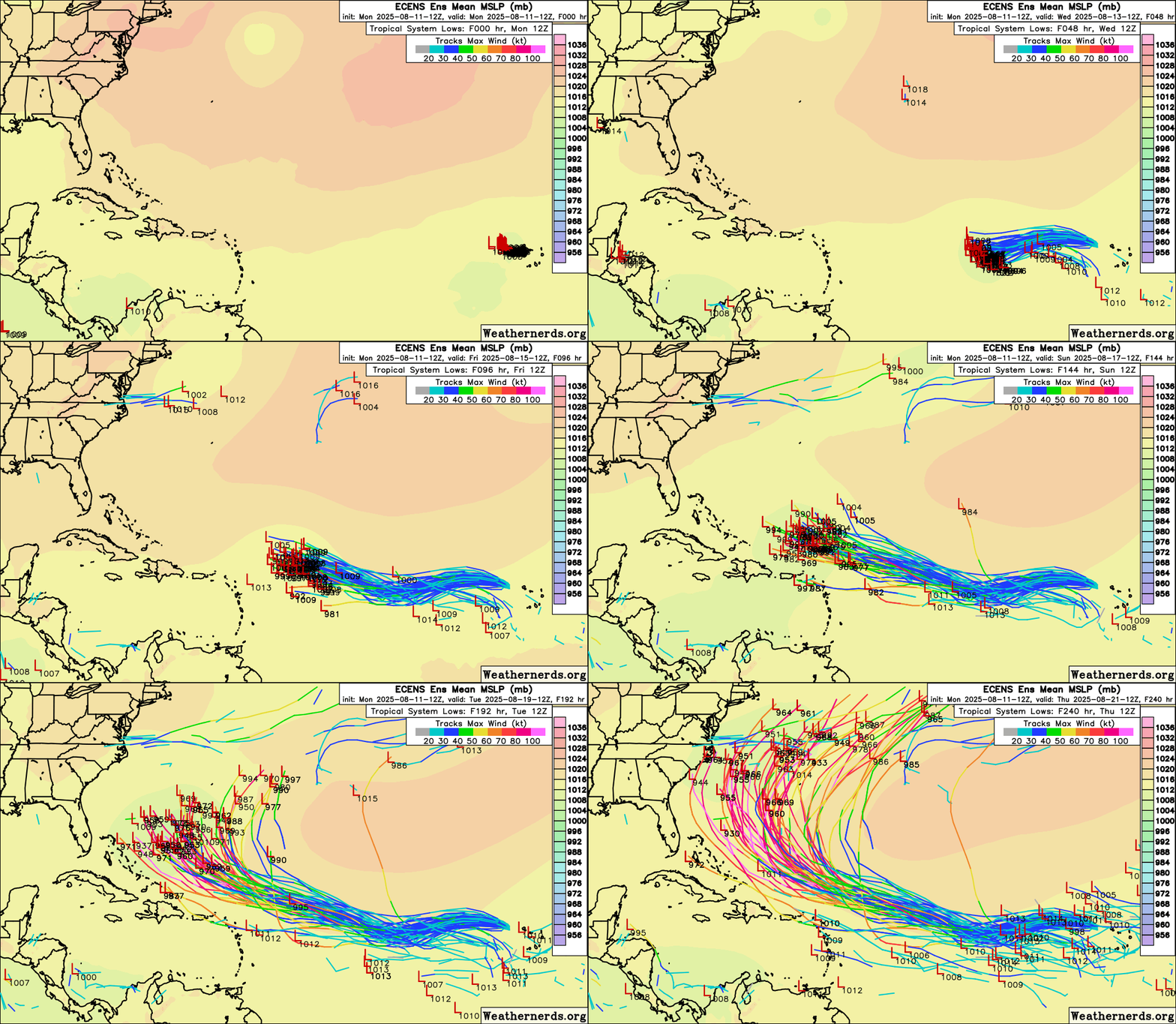
12z euro ensemble animated tracks. Slight right shift from 0z (still a few US hits)


1 likes
-
DunedinDave
- Category 1

- Posts: 269
- Joined: Fri Aug 25, 2023 10:31 am
Re: ATL: ERIN - Models
Stormlover70 wrote:look at Irmas early runs and get back to me.DunedinDave wrote:Still very far out. If I had $100 to wager, I’d put $70 on that it curves out to sea, $20, that it comes close enough to the US to clip Hatteras or the Cape Cod region, and $10 that it stays south and somehow rams into Florida and/or hits the Gulf.
I looked and there were a few that had it taking the southern route. The vibe here so far is that most are in agreeement it won’t do that.
Not saying by any means that won’t change…just saying if I had $100, that’s where my money would go as of now. And hopefully I’m right because I don’t want a US hit.
1 likes
Re: ATL: ERIN - Models
BobHarlem wrote:12z GEFS Ensemble tracks (animated). Slight left overall shift since the 6z.
https://i.postimg.cc/nrSsjNRG/87542089.gif
I counted 6 of 30 (20%) 12Z GEFS members hitting the Conus. I’m not worried about it and am pretty optimistic the U.S. will not be hit, especially considering the current 17.4N latitude so far E in the MDR. But though still small, 20% is the highest since at least 6Z of yesterday fwiw. Likely will go back down later runs of today.
3 likes
Personal Forecast Disclaimer:
The posts in this forum are NOT official forecasts and should not be used as such. They are just the opinion of the poster and may or may not be backed by sound meteorological data. They are NOT endorsed by any professional institution or storm2k.org. For official information, please refer to the NHC and NWS products.
The posts in this forum are NOT official forecasts and should not be used as such. They are just the opinion of the poster and may or may not be backed by sound meteorological data. They are NOT endorsed by any professional institution or storm2k.org. For official information, please refer to the NHC and NWS products.
-
floridasun
- Tropical Storm

- Posts: 245
- Joined: Tue Sep 14, 2021 3:59 pm
Re: ATL: ERIN - Models
Larry nhc saying high maybe strong expect not have weakness so not saying we east coast are not safe we still watch close by weekend so whole east coast and Bermuda need eye on it i know you good but disagree with thisLarryWx wrote:BobHarlem wrote:12z GEFS Ensemble tracks (animated). Slight left overall shift since the 6z.
https://i.postimg.cc/nrSsjNRG/87542089.gif
I counted 6 of 30 (20%) 12Z GEFS members hitting the Conus. I’m not worried about it and am pretty optimistic the U.S. will not be hit, especially considering the current 17.4N latitude so far E in the MDR. But though still small, 20% is the highest since at least 6Z of yesterday fwiw. Likely will go back down later runs of today.
1 likes
Re: ATL: ERIN - Models
18z icon matches 12z position (slightly stronger) at 120 hours (which is as far out as the 18z icon goes).


1 likes
-
floridasun
- Tropical Storm

- Posts: 245
- Joined: Tue Sep 14, 2021 3:59 pm
Re: ATL: ERIN - Models
what i see last part loop of run look like want get close to BahamaBobHarlem wrote:18z icon matches 12z position (slightly stronger) at 120 hours (which is as far out as the 18z icon goes).
[list=][/list]
https://i.imgur.com/Wk1XfoX.png
0 likes
-
Mouton
- S2K Supporter

- Posts: 222
- Age: 80
- Joined: Sat Jul 30, 2011 8:13 am
- Location: Amelia Island Florida
Re: ATL: ERIN - Models
Early on with the projections of Cat 3, my sense is it goes poleward lots of model support for near Bermuda. If it does not develop, and there are indications it may not due to conditions, it could end up somewhere in Florida say north of Palm Beach as a low range Cat 1.
Long range forecast now is for the ridge to the west to go west forming an L over south Florida. Hense my suggestion of north of Palm Beach.
Long range forecast now is for the ridge to the west to go west forming an L over south Florida. Hense my suggestion of north of Palm Beach.
0 likes
-
hohnywx
- Category 2

- Posts: 511
- Age: 35
- Joined: Sun Jul 19, 2009 8:34 pm
- Location: Hastings-on-Hudson, NY
Re: ATL: ERIN - Models
LarryWx wrote:BobHarlem wrote:12z GEFS Ensemble tracks (animated). Slight left overall shift since the 6z.
https://i.postimg.cc/nrSsjNRG/87542089.gif
I counted 6 of 30 (20%) 12Z GEFS members hitting the Conus. I’m not worried about it and am pretty optimistic the U.S. will not be hit, especially considering the current 17.4N latitude so far E in the MDR. But though still small, 20% is the highest since at least 6Z of yesterday fwiw. Likely will go back down later runs of today.
Larry, going back a while at this point, but I believe you had data showing how a WSW movement in the MDR greatly increased the chance of U.S. impacts? I tried searching but came up empty.
1 likes
-
hohnywx
- Category 2

- Posts: 511
- Age: 35
- Joined: Sun Jul 19, 2009 8:34 pm
- Location: Hastings-on-Hudson, NY
Re: ATL: ERIN - Models
BobHarlem wrote:18z icon matches 12z position (slightly stronger) at 120 hours (which is as far out as the 18z icon goes).
https://i.imgur.com/Wk1XfoX.png
Slightly west of 12z
https://x.com/FloridaTropics1/status/1955019995278164218
0 likes
Re: ATL: ERIN - Models
CrazyC83 wrote:Even if it recurves, there's still land sitting there (Bermuda).
The 12Z JMA hits Bermuda directly.
0 likes
Personal Forecast Disclaimer:
The posts in this forum are NOT official forecasts and should not be used as such. They are just the opinion of the poster and may or may not be backed by sound meteorological data. They are NOT endorsed by any professional institution or storm2k.org. For official information, please refer to the NHC and NWS products.
The posts in this forum are NOT official forecasts and should not be used as such. They are just the opinion of the poster and may or may not be backed by sound meteorological data. They are NOT endorsed by any professional institution or storm2k.org. For official information, please refer to the NHC and NWS products.
-
hurricane2025
- Category 1

- Posts: 254
- Joined: Thu Apr 08, 2021 10:36 am
Re: ATL: ERIN - Models
Tbh longs way out don’t be surprise of a close USA landfall on these 18z runs always happens
Last edited by hurricane2025 on Mon Aug 11, 2025 5:24 pm, edited 2 times in total.
0 likes
- cycloneye
- Admin

- Posts: 149727
- Age: 69
- Joined: Thu Oct 10, 2002 10:54 am
- Location: San Juan, Puerto Rico
Re: ATL: ERIN - Models
18z GFS a little bit closer to the northern Leewards, BVI, USVI and Puerto Rico.


0 likes
Visit the Caribbean-Central America Weather Thread where you can find at first post web cams,radars
and observations from Caribbean basin members Click Here
and observations from Caribbean basin members Click Here
- chris_fit
- Category 5

- Posts: 3261
- Age: 43
- Joined: Wed Sep 10, 2003 11:58 pm
- Location: Tampa Bay Area, FL
Re: ATL: ERIN - Models
On my phone so cant post graphic but GFS notable massive shift W for the 18z run. Almost in the Bahamas.
Last edited by chris_fit on Mon Aug 11, 2025 5:26 pm, edited 1 time in total.
0 likes
- Category5Kaiju
- Category 5

- Posts: 4347
- Joined: Thu Dec 24, 2020 12:45 pm
- Location: Seattle during the summer, Phoenix during the winter
Re: ATL: ERIN - Models
Ooh, this 18z GFS run is looking....interesting, to say the least.
At least by hour 174, this is the furthest south and west that Erin has been projected to be since the 0z/6z runs on August 9.
At least by hour 174, this is the furthest south and west that Erin has been projected to be since the 0z/6z runs on August 9.
0 likes
Unless explicitly stated, all information in my posts is based on my own opinions and observations. Tropical storms and hurricanes can be extremely dangerous. Refer to an accredited weather research agency or meteorologist if you need to make serious decisions regarding an approaching storm.
Re: ATL: ERIN - Models
Furthest Southwest the GFS has been since the Saturday 0z. No landfall however.


Last edited by BobHarlem on Mon Aug 11, 2025 5:54 pm, edited 1 time in total.
0 likes
Re: ATL: ERIN - Models
hohnywx wrote:LarryWx wrote:BobHarlem wrote:12z GEFS Ensemble tracks (animated). Slight left overall shift since the 6z.
https://i.postimg.cc/nrSsjNRG/87542089.gif
I counted 6 of 30 (20%) 12Z GEFS members hitting the Conus. I’m not worried about it and am pretty optimistic the U.S. will not be hit, especially considering the current 17.4N latitude so far E in the MDR. But though still small, 20% is the highest since at least 6Z of yesterday fwiw. Likely will go back down later runs of today.
Larry, going back a while at this point, but I believe you had data showing how a WSW movement in the MDR greatly increased the chance of U.S. impacts? I tried searching but came up empty.
Yes, I remember doing that study. The reason for this appears to be that when there’s a strong enough E Atlantic/Azores high to cause WSW motion in the E MDR, it often teleconnects with less protection for the Conus from steering than usual for a TCG in the E Atlantic.
I’d like to find the actual details. Examples of E Atlantic WSW motion that hit the Conus include:
-#6 of 1893
-#4 of 1928
-#4 of 1947
-#2 of 1952
-#6 of 1964
-Hugo of 1989
-Isabel of 2003
-Ivan of 2004
Note though that these were all S of 16N and almost all S of 15N when they made their WSW motion.
(Irma of 2017’s WSW motion was W of 40W)
Last edited by LarryWx on Mon Aug 11, 2025 5:37 pm, edited 1 time in total.
3 likes
Personal Forecast Disclaimer:
The posts in this forum are NOT official forecasts and should not be used as such. They are just the opinion of the poster and may or may not be backed by sound meteorological data. They are NOT endorsed by any professional institution or storm2k.org. For official information, please refer to the NHC and NWS products.
The posts in this forum are NOT official forecasts and should not be used as such. They are just the opinion of the poster and may or may not be backed by sound meteorological data. They are NOT endorsed by any professional institution or storm2k.org. For official information, please refer to the NHC and NWS products.
-
AxaltaRacing24
- Category 5

- Posts: 1774
- Age: 25
- Joined: Wed Jul 27, 2016 11:14 am
- Location: Jupiter, FL
Re: ATL: ERIN - Models
it’ll recurve this run, but compare this to the 18Z yesterday and look at the trend.
1 likes
- StormWeather
- Category 1

- Posts: 477
- Joined: Wed Jun 05, 2024 2:34 pm
Re: ATL: ERIN - Models
AxaltaRacing24 wrote:it’ll recurve this run, but compare this to the 18Z yesterday and look at the trend.
Compared to the 00Z, 06Z and 12Z runs of the GFS today by 120+ hours, that is a huge trend southwards.
0 likes
Just an average cyclone tracker
The posts in this forum are NOT official forecasts and should not be used as such. They are just the opinion of the poster and may or may not be backed by sound meteorological data. They are NOT endorsed by any professional institution or storm2k.org. For official information, please refer to the NHC and NWS products
The posts in this forum are NOT official forecasts and should not be used as such. They are just the opinion of the poster and may or may not be backed by sound meteorological data. They are NOT endorsed by any professional institution or storm2k.org. For official information, please refer to the NHC and NWS products
Who is online
Users browsing this forum: No registered users and 39 guests

