ATL: ERIN - Models

Moderator: S2k Moderators

Message
Author
LarryWx
S2K Supporter
S2K Supporter
Posts: 6513
Joined: Sun Sep 07, 2003 2:04 pm
Location: GA

Re: ATL: ERIN - Models

#381 Postby LarryWx » Wed Aug 13, 2025 7:46 pm

Kingarabian wrote:18z Euro is a bit more SW at hour 72 compared to the 12z run.


Thanks, King.
At 144, the 18Z Euro is slightly SE of the 12Z at 150.
1 likes   
Personal Forecast Disclaimer:
The posts in this forum are NOT official forecasts and should not be used as such. They are just the opinion of the poster and may or may not be backed by sound meteorological data. They are NOT endorsed by any professional institution or storm2k.org. For official information, please refer to the NHC and NWS products.

User avatar
cycloneye
Admin
Admin
Posts: 146370
Age: 69
Joined: Thu Oct 10, 2002 10:54 am
Location: San Juan, Puerto Rico

Re: ATL: ERIN - Models

#382 Postby cycloneye » Wed Aug 13, 2025 8:07 pm

00z SHIPS run.

Image
0 likes   
Visit the Caribbean-Central America Weather Thread where you can find at first post web cams,radars
and observations from Caribbean basin members Click Here

BobHarlem
Category 5
Category 5
Posts: 2362
Joined: Thu Oct 20, 2005 6:11 pm

Re: ATL: ERIN - Models

#383 Postby BobHarlem » Wed Aug 13, 2025 8:26 pm

TVCN consensus trend since the start, 0z shifts left again.

Image
2 likes   

User avatar
cycloneye
Admin
Admin
Posts: 146370
Age: 69
Joined: Thu Oct 10, 2002 10:54 am
Location: San Juan, Puerto Rico

Re: ATL: ERIN - Models

#384 Postby cycloneye » Wed Aug 13, 2025 8:36 pm

00z Spaghetti models are clear from the islands and also from CONUS and Bermuda.

Image

Image
2 likes   
Visit the Caribbean-Central America Weather Thread where you can find at first post web cams,radars
and observations from Caribbean basin members Click Here

User avatar
Hurricane2022
Category 5
Category 5
Posts: 1648
Joined: Tue Aug 23, 2022 11:38 pm
Location: Araçatuba, Brazil

Re: ATL: ERIN - Models

#385 Postby Hurricane2022 » Wed Aug 13, 2025 9:04 pm

0 likes   
Sorry for the bad English sometimes...!
For reliable and detailed information for any meteorological phenomenon, please consult the National Hurricane Center, Joint Typhoon Warning Center , or your local Meteo Center.

--------

Una cvm Christo, pro Christo, et in Christo. Sit nomen Domini benedictvm.

User avatar
Teban54
Category 5
Category 5
Posts: 3269
Joined: Sat May 19, 2018 1:19 pm

Re: ATL: ERIN - Models

#386 Postby Teban54 » Wed Aug 13, 2025 9:06 pm

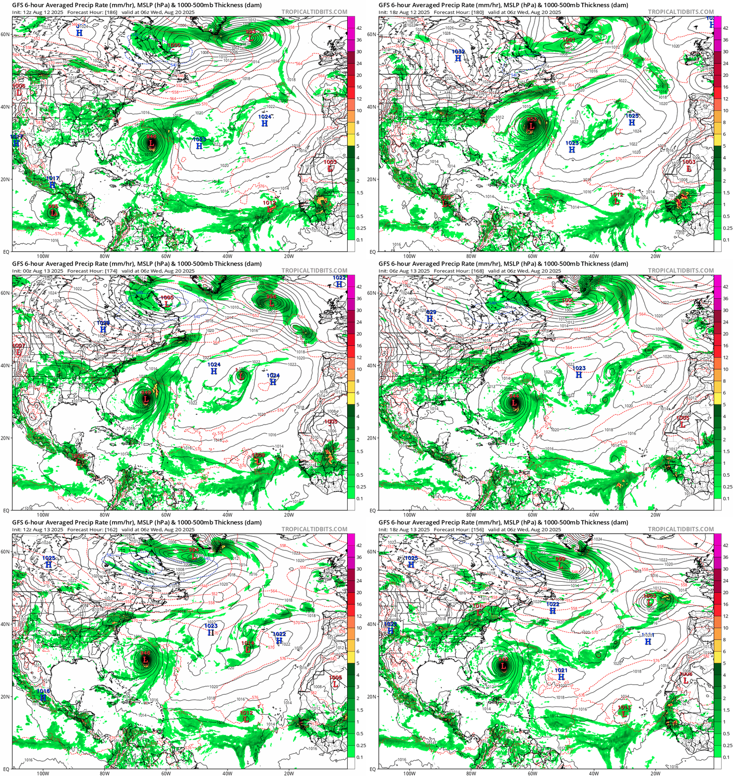
GFS trend over the past 6 runs. The 18z run is notably slower and more west, despite still further away from US than other global models.

Image
1 likes   

User avatar
Iceresistance
Category 5
Category 5
Posts: 9298
Age: 21
Joined: Sat Oct 10, 2020 9:45 am
Location: Tecumseh, OK/Norman, OK

ATL: INVEST 98L - Models

#387 Postby Iceresistance » Wed Aug 13, 2025 9:16 pm

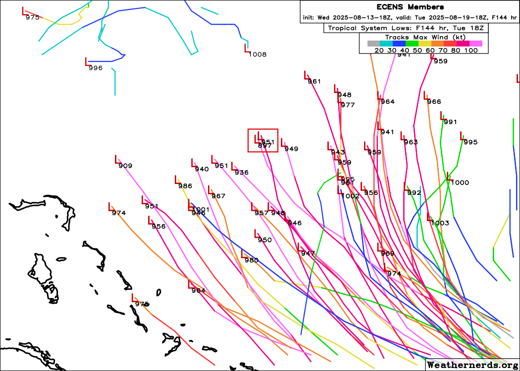
18z EPS has a 897 mb member, the first sub-900 member for Erin

Image
https://s14.gifyu.com/images/bN4rL.png
5 likes   
Bill 2015 & Beta 2020

Winter 2020-2021 :cold:

All observations are in Tecumseh, OK unless otherwise noted.

Winter posts are focused mainly for Oklahoma & Texas.

Take any of my forecasts with a grain of salt, refer to the NWS, SPC, and NHC for official information

Never say Never with weather! Because ANYTHING is possible!

User avatar
Teban54
Category 5
Category 5
Posts: 3269
Joined: Sat May 19, 2018 1:19 pm

Re: ATL: INVEST 98L - Models

#388 Postby Teban54 » Wed Aug 13, 2025 9:27 pm

Iceresistance wrote:18z EPS has a 897 mb member, the first sub-900 member for Erin

https://s14.gifyu.com/images/bN4rL.png

Meanwhile, there are three 1000+ mb members to the east. That's a model spread of more than 100 mb! :lol:
1 likes   

BobHarlem
Category 5
Category 5
Posts: 2362
Joined: Thu Oct 20, 2005 6:11 pm

Re: ATL: ERIN - Models

#389 Postby BobHarlem » Wed Aug 13, 2025 10:17 pm

0z icon is left of the 18z at the same time frame, close enough for the Bahamas to feel it here. At 150 hours out its getting close to cat 5 again.

Image

Ridge situation is very different than the GFS
Image
Last edited by BobHarlem on Wed Aug 13, 2025 10:25 pm, edited 1 time in total.
2 likes   

caneseddy
Category 5
Category 5
Posts: 1181
Joined: Fri Sep 03, 2004 9:31 pm
Location: Plantation, FL

Re: ATL: ERIN - Models

#390 Postby caneseddy » Wed Aug 13, 2025 10:25 pm

Still looking to recrurve but that ICON run is getting a bit too close to the coast for my liking...also bombing it out to Cat 5 just north of the Bahamas (918 mb)
0 likes   

User avatar
Kingarabian
S2K Supporter
S2K Supporter
Posts: 16112
Joined: Sat Aug 08, 2009 3:06 am
Location: Honolulu, Hawaii

Re: ATL: ERIN - Models

#391 Postby Kingarabian » Wed Aug 13, 2025 10:28 pm

Another S/SW shift on the 00z ICON.
0 likes   
RIP Kobe Bryant

Fancy1002
Tropical Storm
Tropical Storm
Posts: 179
Joined: Sun Dec 25, 2022 3:47 pm

Re: ATL: ERIN - Models

#392 Postby Fancy1002 » Wed Aug 13, 2025 10:30 pm

Is it just me, or is a brush or direct impact on the edge of North Carolina looking a bit more likely with each run, at least on the icon and euro, wish we could se further out on the haps’s
0 likes   

BobHarlem
Category 5
Category 5
Posts: 2362
Joined: Thu Oct 20, 2005 6:11 pm

Re: ATL: ERIN - Models

#393 Postby BobHarlem » Wed Aug 13, 2025 10:32 pm

0z Icon, Left of 18z and 12z. Cat 4/5 waaay too close to the OBX.
Image

Looking at the ridging on that model if it shifts left again like that again, it's landfall.
Last edited by BobHarlem on Wed Aug 13, 2025 10:40 pm, edited 1 time in total.
2 likes   

AxaltaRacing24
Category 5
Category 5
Posts: 1766
Age: 25
Joined: Wed Jul 27, 2016 11:14 am
Location: Jupiter, FL

Re: ATL: ERIN - Models

#394 Postby AxaltaRacing24 » Wed Aug 13, 2025 10:37 pm

Fancy1002 wrote:Is it just me, or is a brush or direct impact on the edge of North Carolina looking a bit more likely with each run, at least on the icon and euro, wish we could se further out on the haps’s

If anything, the east of Bermuda scenario is becoming less likely.
1 likes   

Sailingtime
Tropical Low
Tropical Low
Posts: 38
Joined: Thu Aug 29, 2019 7:02 pm

Re: ATL: ERIN - Models

#395 Postby Sailingtime » Wed Aug 13, 2025 10:46 pm

OuterBanker wrote:One other thing.
If anyone has a Caribbean cruise slated for this weekend, I suggest that you cancel.


Ships will go around the storm/change up their itinerary but in general, no cruising August - October time frame if you want to play it safe.
The models have been consistent with the turn and keeping Erin well off the U.S. coast but you never really know until the storm actually does what it's "predicted" to do.
0 likes   

Keldeo1997
Category 2
Category 2
Posts: 655
Joined: Fri Oct 11, 2019 11:35 pm

Re: ATL: ERIN - Models

#396 Postby Keldeo1997 » Wed Aug 13, 2025 11:08 pm

Uhhh don't look at the ICON ensembles

 https://x.com/FLStormChasers_/status/1955842062617862291

0 likes   

LarryWx
S2K Supporter
S2K Supporter
Posts: 6513
Joined: Sun Sep 07, 2003 2:04 pm
Location: GA

Re: ATL: ERIN - Models

#397 Postby LarryWx » Wed Aug 13, 2025 11:10 pm

0Z UKMET is similar to 12Z with recurve at 71.7W

TROPICAL STORM ERIN ANALYSED POSITION : 16.4N 45.8W

ATCF IDENTIFIER : AL052025

LEAD CENTRAL MAXIMUM WIND
VERIFYING TIME TIME POSITION PRESSURE (MB) SPEED (KNOTS)
-------------- ---- -------- ------------- -------------
0000UTC 14.08.2025 0 16.4N 45.8W 1007 31
1200UTC 14.08.2025 12 16.7N 48.8W 1006 31
0000UTC 15.08.2025 24 17.8N 51.8W 1006 32
1200UTC 15.08.2025 36 19.0N 55.5W 1006 32
0000UTC 16.08.2025 48 20.0N 58.9W 1005 33
1200UTC 16.08.2025 60 20.5N 62.6W 1002 33
0000UTC 17.08.2025 72 20.4N 65.4W 999 32
1200UTC 17.08.2025 84 20.6N 67.2W 997 34
0000UTC 18.08.2025 96 22.3N 68.2W 994 40
1200UTC 18.08.2025 108 24.2N 69.6W 992 44
0000UTC 19.08.2025 120 26.1N 70.6W 989 46
1200UTC 19.08.2025 132 27.9N 71.3W 986 50
0000UTC 20.08.2025 144 30.0N 71.7W 982 52
1200UTC 20.08.2025 156 32.5N 71.5W 979 58

0000UTC 21.08.2025 168 35.0N 70.3W 972 62
0 likes   
Personal Forecast Disclaimer:
The posts in this forum are NOT official forecasts and should not be used as such. They are just the opinion of the poster and may or may not be backed by sound meteorological data. They are NOT endorsed by any professional institution or storm2k.org. For official information, please refer to the NHC and NWS products.

User avatar
Kingarabian
S2K Supporter
S2K Supporter
Posts: 16112
Joined: Sat Aug 08, 2009 3:06 am
Location: Honolulu, Hawaii

Re: ATL: ERIN - Models

#398 Postby Kingarabian » Wed Aug 13, 2025 11:14 pm

00z CMC shifting west as well. Similar to the 8/12 00z run through hour 84.
0 likes   
RIP Kobe Bryant

IsabelaWeather
Category 1
Category 1
Posts: 291
Age: 36
Joined: Tue Jul 07, 2020 7:29 am
Location: Isabela, Puerto Rico

Re: ATL: ERIN - Models

#399 Postby IsabelaWeather » Wed Aug 13, 2025 11:15 pm

LarryWx wrote:0Z UKMET is similar to 12Z with recurve at 71.7W

TROPICAL STORM ERIN ANALYSED POSITION : 16.4N 45.8W

ATCF IDENTIFIER : AL052025

LEAD CENTRAL MAXIMUM WIND
VERIFYING TIME TIME POSITION PRESSURE (MB) SPEED (KNOTS)
-------------- ---- -------- ------------- -------------
0000UTC 14.08.2025 0 16.4N 45.8W 1007 31
1200UTC 14.08.2025 12 16.7N 48.8W 1006 31
0000UTC 15.08.2025 24 17.8N 51.8W 1006 32
1200UTC 15.08.2025 36 19.0N 55.5W 1006 32
0000UTC 16.08.2025 48 20.0N 58.9W 1005 33
1200UTC 16.08.2025 60 20.5N 62.6W 1002 33
0000UTC 17.08.2025 72 20.4N 65.4W 999 32
1200UTC 17.08.2025 84 20.6N 67.2W 997 34
0000UTC 18.08.2025 96 22.3N 68.2W 994 40
1200UTC 18.08.2025 108 24.2N 69.6W 992 44
0000UTC 19.08.2025 120 26.1N 70.6W 989 46
1200UTC 19.08.2025 132 27.9N 71.3W 986 50
0000UTC 20.08.2025 144 30.0N 71.7W 982 52
1200UTC 20.08.2025 156 32.5N 71.5W 979 58
0000UTC 21.08.2025 168 35.0N 70.3W 972 62


Looks closer than I remember other runs. Places it just 130 miles from me. Looks like another southward jog. I think the last one was near 22N at 67W
1 likes   

convergencezone2
Tropical Low
Tropical Low
Posts: 11
Joined: Tue Jul 29, 2025 4:03 pm

Re: ATL: ERIN - Models

#400 Postby convergencezone2 » Wed Aug 13, 2025 11:21 pm

interesting trends with some of the models today / tonight. It will also interesteing to see how much this affects wave action along the east coast if it gets a bit closer.
0 likes   


Return to “2025”

Who is online

Users browsing this forum: No registered users and 18 guests