ATL: ERIN - Hurricane - Discussion

Current storms and invests:

Moderators: hurricanetrack, S2k Moderators


The posts in this forum are NOT official forecasts and should not be used as such. They are just the opinion of the poster and may or may not be backed by sound meteorological data. They are NOT endorsed by any professional institution or STORM2K. For official information, please refer to products from the National Hurricane Center and National Weather Service.

Help Support Storm2K
Message
Author
SpaceCowboy
Tropical Wave
Tropical Wave
Posts: 4
Joined: Sun Oct 06, 2024 10:31 am

Re: ATL: ERIN - Tropical Storm - Discussion: TS Watch issued for Northern Leewards

#601 Postby SpaceCowboy » Sat Aug 16, 2025 8:49 am

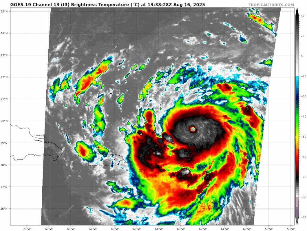
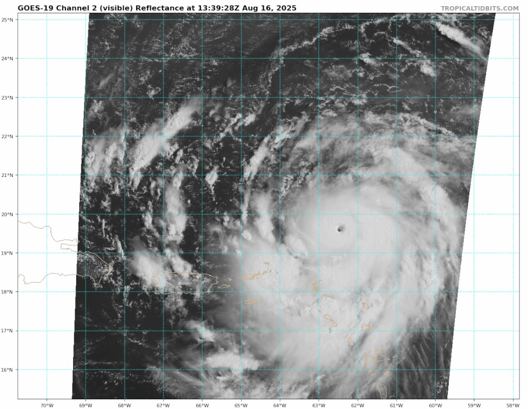
SpaceCowboy wrote:Am I the only person that feels like none of the models (not the actual data being collected but the forecast models and trajectories) are completely out of wack?

I am no meteorologist like half of you, and have even less formal education or study than all of you lol… but from 31 years experience of hurricanes, this one is really shaping out weird. And for some reason I can’t fight the gut feeling that provided the data collected today, either something isn’t being said (or projected), and this thing might smack right into somewhere on the east coast somewhere north of Broward or up in NC near MB.


Quoting this because that same “gut” feeling, is getting “guttier”…

Looks like that one EU model + the ICON have been the most accurate indicating models so far; I remember seeing on Tidbits or one of the random Facebook pages several EU models that put this thing through the Caribbean & possibly hitting the south east US.

I don’t know, man. If I there isn’t a jog or some wobble to the WNW soon, I’m starting to think I better go do some prepping.

Keeping everyone on the islands; SXM + SBH, PR, Bahamas - in my prayers.
0 likes   

User avatar
tropicwatch
Category 5
Category 5
Posts: 3400
Age: 61
Joined: Sat Jun 02, 2007 10:01 am
Location: Panama City Florida
Contact:

Re: ATL: ERIN - Hurricane - Discussion

#602 Postby tropicwatch » Sat Aug 16, 2025 8:53 am

So far it looks like Erin doesn't want to go right. Very disturbing trend at this point. As usual hurricanes like throwing wrenches where they don't need to be 8-)
2 likes   
Tropicwatch


Agnes 72', Eloise 75, Elena 85', Kate 85', Charley 86', Florence 88', Beryl 94', Dean 95', Erin 95', Opal 95', Earl 98', Georges 98', Ivan 2004', Arlene 2005', Dennis 2005', Ida 2009' Debby 2012' Irma 2017' Michael 2018'

User avatar
cycloneye
Admin
Admin
Posts: 146106
Age: 69
Joined: Thu Oct 10, 2002 10:54 am
Location: San Juan, Puerto Rico

Re: ATL: ERIN - Hurricane - Discussion

#603 Postby cycloneye » Sat Aug 16, 2025 8:53 am

1 likes   
Visit the Caribbean-Central America Weather Thread where you can find at first post web cams,radars
and observations from Caribbean basin members Click Here

MarioProtVI
Category 4
Category 4
Posts: 946
Age: 24
Joined: Sun Sep 29, 2019 7:33 pm
Location: New Jersey

Re: ATL: ERIN - Hurricane - Discussion

#604 Postby MarioProtVI » Sat Aug 16, 2025 8:55 am

I knew Erin was gonna blow when I went to bed at 3 this morning but I wasn’t expecting it THIS intense…we likely have our first August Cat 5 since KATRINA. Absolutely insane. Feels like watching Milton explode all over again.
4 likes   

User avatar
msbee
S2K Supporter
S2K Supporter
Posts: 3037
Joined: Wed Jun 11, 2003 10:11 am
Location: St. Maarten

Re: ATL: ERIN - Hurricane - Discussion

#605 Postby msbee » Sat Aug 16, 2025 8:55 am

Hi, just a quick update from St Maarten.
The north eastern Caribbean islands really lucked out on this one. I couldn’t believe when I woke up this morning that she was a cat four.
It was a total nonevent for us. We got some rain but not much. We heard some thunder but not much and we got no wind basically.
We needed the rain so that was a blessing. And it looks like we’ll get some light rain off and on today, which we can certainly use.
I am hoping Erin stays far away from all land.
8 likes   
Too many hurricanes to remember

User avatar
eastcoastFL
Category 5
Category 5
Posts: 3923
Age: 43
Joined: Thu Apr 12, 2007 12:29 pm
Location: Palm City, FL

Re: ATL: ERIN - Hurricane - Discussion

#606 Postby eastcoastFL » Sat Aug 16, 2025 8:57 am

Erin also appears to be south of track as well.

At 5am she was at 19.8N 61.1W she's now slightly south of that and about 1 degrees west. I wonder how that will factor into models later today.

Image
1 likes   
Personal Forecast Disclaimer:
The posts in this forum are NOT official forecast and should not be used as such. They are just the opinion of the poster and may or may not be backed by sound meteorological data. They are NOT endorsed by any professional institution or storm2k.org. For official information, please refer to the NHC and NWS products.

WeatherBoy2000
Category 1
Category 1
Posts: 389
Joined: Mon Apr 10, 2023 9:29 am

Re: ATL: ERIN - Hurricane - Discussion

#607 Postby WeatherBoy2000 » Sat Aug 16, 2025 8:57 am

Kingarabian wrote:Erin looks pretty big on satellite. The fact it's forecast to double or triple in size is insane.


The predicted satellite presentation in the subtropics is near comical:

 https://x.com/BenNollWeather/status/1956702490289635409

0 likes   

WeatherBoy2000
Category 1
Category 1
Posts: 389
Joined: Mon Apr 10, 2023 9:29 am

Re: ATL: ERIN - Hurricane - Discussion

#608 Postby WeatherBoy2000 » Sat Aug 16, 2025 8:59 am

MarioProtVI wrote:I knew Erin was gonna blow when I went to bed at 3 this morning but I wasn’t expecting it THIS intense…we likely have our first August Cat 5 since KATRINA. Absolutely insane. Feels like watching Milton explode all over again.


The last August cat 5 was actually Dean in 2007. This is also the first mid-August major since the 2000s as well.
2 likes   

BobHarlem
Category 5
Category 5
Posts: 2313
Joined: Thu Oct 20, 2005 6:11 pm

Re: ATL: ERIN - Hurricane - Discussion

#609 Postby BobHarlem » Sat Aug 16, 2025 9:00 am

200-700mb steering right now from https://tropic.ssec.wisc.edu/real-time/ ... oom=&time=

Just a heads up, this changes fairly rapidly, so its more for the very near term. But the intensity changes is going to make these kinda worthless.

Image
Last edited by BobHarlem on Sat Aug 16, 2025 9:08 am, edited 1 time in total.
0 likes   

User avatar
NDG
S2K Supporter
S2K Supporter
Posts: 15463
Joined: Sun Jul 09, 2006 10:14 pm
Location: Orlando, FL

Re: ATL: ERIN - Hurricane - Discussion

#610 Postby NDG » Sat Aug 16, 2025 9:04 am

Hopefully the NHC on their next update will finally recognize the almost due west heading during past 12+ hours and will start putting less confidence on the right biased models like the GFS.
3 likes   

KeysRedWine
Tropical Wave
Tropical Wave
Posts: 6
Age: 41
Joined: Thu Sep 19, 2024 12:30 pm
Location: Summerland Key, FL

Re: ATL: ERIN - Hurricane - Discussion

#611 Postby KeysRedWine » Sat Aug 16, 2025 9:06 am

BobHarlem wrote:200-700mb steering right now from https://tropic.ssec.wisc.edu/real-time/ ... oom=&time=

Just a heads up, this changes fairly rapidly, so its more for the very near term.

https://i.imgur.com/922w4aA.gif
Last edited by KeysRedWine on Sat Aug 16, 2025 9:08 am, edited 1 time in total.
0 likes   

Fancy1002
Tropical Storm
Tropical Storm
Posts: 172
Joined: Sun Dec 25, 2022 3:47 pm

Re: ATL: ERIN - Hurricane - Discussion

#612 Postby Fancy1002 » Sat Aug 16, 2025 9:06 am

I went to bed with a cat two, and woke up to a near cat five, nice job Erin.
3 likes   

KeysRedWine
Tropical Wave
Tropical Wave
Posts: 6
Age: 41
Joined: Thu Sep 19, 2024 12:30 pm
Location: Summerland Key, FL

Re: ATL: ERIN - Hurricane - Discussion

#613 Postby KeysRedWine » Sat Aug 16, 2025 9:06 am

KeysRedWine wrote:
BobHarlem wrote:200-700mb steering right now from https://tropic.ssec.wisc.edu/real-time/ ... oom=&time=

Just a heads up, this changes fairly rapidly, so its more for the very near term.

https://i.imgur.com/922w4aA.gif


That's quite scary....might continue westward a while longer
0 likes   

TampaWxLurker
Tropical Storm
Tropical Storm
Posts: 142
Joined: Thu Aug 01, 2024 8:20 am

Re: ATL: ERIN - Hurricane - Discussion

#614 Postby TampaWxLurker » Sat Aug 16, 2025 9:10 am

Very interested to see what NHC does with the track and watches/warnings at 11am. Everything probably shifts a bit west and the USVI/PR get a watch/warning.
0 likes   

User avatar
GCANE
S2K Supporter
S2K Supporter
Posts: 11617
Joined: Mon Oct 22, 2007 8:03 am

Re: ATL: ERIN - Hurricane - Discussion

#615 Postby GCANE » Sat Aug 16, 2025 9:10 am

Right now the anti-cyclone associated with Erin and an ULL to the west in the southern Bahamas is creating a strong shear gradient west of Erin.
Max shear is currently over DR.
0 likes   

FrontRunner
Tropical Depression
Tropical Depression
Posts: 66
Age: 41
Joined: Wed Aug 23, 2006 9:01 pm
Location: Westchester, NY

Re: ATL: ERIN - Hurricane - Discussion

#616 Postby FrontRunner » Sat Aug 16, 2025 9:10 am

eastcoastFL wrote:
Hurricane2022 wrote:And here I am, violently refreshing the NHC's page waiting for an Update Statement :onfire:


I don't think we will get one until the 11am update. Mainly since it's not currently a direct threat to land.


It's more timing than anything. They did an update this morning when she went to Cat 4, but that's because it was so soon after the prior advisory. They probably figure they're close enough to 15z to just wait for that advisory.
1 likes   

User avatar
Teban54
Category 5
Category 5
Posts: 3243
Joined: Sat May 19, 2018 1:19 pm

Re: ATL: ERIN - Hurricane - Discussion

#617 Postby Teban54 » Sat Aug 16, 2025 9:11 am

Image

Image
3 likes   

User avatar
Woofde
Category 1
Category 1
Posts: 493
Joined: Tue Jul 06, 2021 11:33 am

Re: ATL: ERIN - Hurricane - Discussion

#618 Postby Woofde » Sat Aug 16, 2025 9:12 am

Frankly almost unbelievable to be looking at a likely Cat 5 hurricane this soon. I knew it poised to blowup yesterday but not this much... Yet another case of ERI, is this the new normal going forward?
2 likes   

HurricaneRyan
Category 3
Category 3
Posts: 817
Age: 31
Joined: Sun Dec 05, 2010 3:05 pm

Re: ATL: ERIN - Hurricane - Discussion

#619 Postby HurricaneRyan » Sat Aug 16, 2025 9:13 am

My Isabel comparison yesterday suddenly not so extreme anymore
4 likes   
Kay '22 Hilary '23

User avatar
eastcoastFL
Category 5
Category 5
Posts: 3923
Age: 43
Joined: Thu Apr 12, 2007 12:29 pm
Location: Palm City, FL

Re: ATL: ERIN - Hurricane - Discussion

#620 Postby eastcoastFL » Sat Aug 16, 2025 9:13 am

TampaWxLurker wrote:Very interested to see what NHC does with the track and watches/warnings at 11am. Everything probably shifts a bit west and the USVI/PR get a watch/warning.


I would think so too. It's getting hard to ignore the western component. It's been due west so long now the entire visible loop is just one long loop heading due west.
0 likes   
Personal Forecast Disclaimer:
The posts in this forum are NOT official forecast and should not be used as such. They are just the opinion of the poster and may or may not be backed by sound meteorological data. They are NOT endorsed by any professional institution or storm2k.org. For official information, please refer to the NHC and NWS products.


Return to “Active Storms/Invests - Atlantic/EastPAC/CentralPAC/MED”

Who is online

Users browsing this forum: No registered users and 78 guests