ATL: ERIN - Hurricane - Discussion

Current storms and invests:

Moderators: hurricanetrack, S2k Moderators


The posts in this forum are NOT official forecasts and should not be used as such. They are just the opinion of the poster and may or may not be backed by sound meteorological data. They are NOT endorsed by any professional institution or STORM2K. For official information, please refer to products from the National Hurricane Center and National Weather Service.

Help Support Storm2K
Message
Author
User avatar
aspen
Category 5
Category 5
Posts: 8864
Joined: Sat Oct 12, 2019 7:10 pm
Location: Connecticut, USA

Re: ATL: ERIN - Hurricane - Discussion

#881 Postby aspen » Sun Aug 17, 2025 6:41 pm

Category5Kaiju wrote:https://i.imgur.com/qyH3cMM.png

Hot waters lie ahead of Erin. The storm hasn't even reached the true 30 C waters yet.

Hurricane models seem to be in strong agreement that some disruptive shear will start soon and prevent Erin from taking advantage of those waters, though. Might even start as early as overnight.
2 likes   
Irene '11 Sandy '12 Hermine '16 5/15/2018 Derecho Fay '20 Isaias '20 Elsa '21 Henri '21 Ida '21

I am only a meteorology enthusiast who knows a decent amount about tropical cyclones. Look to the professional mets, the NHC, or your local weather office for the best information.

User avatar
eastcoastFL
Category 5
Category 5
Posts: 3929
Age: 43
Joined: Thu Apr 12, 2007 12:29 pm
Location: Palm City, FL

Re: ATL: ERIN - Hurricane - Discussion

#882 Postby eastcoastFL » Sun Aug 17, 2025 6:41 pm

Pretty cool look at the last 48 hours where you can see the EWRC. Its impressive how much larger the eye is now.

Image
10 likes   
Personal Forecast Disclaimer:
The posts in this forum are NOT official forecast and should not be used as such. They are just the opinion of the poster and may or may not be backed by sound meteorological data. They are NOT endorsed by any professional institution or storm2k.org. For official information, please refer to the NHC and NWS products.

User avatar
eastcoastFL
Category 5
Category 5
Posts: 3929
Age: 43
Joined: Thu Apr 12, 2007 12:29 pm
Location: Palm City, FL

Re: ATL: ERIN - Hurricane - Discussion

#883 Postby eastcoastFL » Sun Aug 17, 2025 6:43 pm

aspen wrote:
Category5Kaiju wrote:https://i.imgur.com/qyH3cMM.png

Hot waters lie ahead of Erin. The storm hasn't even reached the true 30 C waters yet.

Hurricane models seem to be in strong agreement that some disruptive shear will start soon and prevent Erin from taking advantage of those waters, though. Might even start as early as overnight.


The NHC has her regaining Cat 4 strength in the next 24 hours. So it looks like she at least gets one more shot.
2 likes   
Personal Forecast Disclaimer:
The posts in this forum are NOT official forecast and should not be used as such. They are just the opinion of the poster and may or may not be backed by sound meteorological data. They are NOT endorsed by any professional institution or storm2k.org. For official information, please refer to the NHC and NWS products.

User avatar
Jr0d
S2K Supporter
S2K Supporter
Posts: 1426
Joined: Tue Aug 27, 2019 10:52 am
Location: Cayo Hueso

Re: ATL: ERIN - Hurricane - Discussion

#884 Postby Jr0d » Sun Aug 17, 2025 7:27 pm

OuterBanker wrote:Could happen, yes.

NCC055-182101-

BULLETIN - EAS ACTIVATION REQUESTED
Local Area Emergency
NC Dare County Emergency Management
Relayed by National Weather Service Newport/Morehead City NC
601 PM EDT Sun Aug 17 2025

...DARE COUNTY EM: MANDATORY EVACUATION ORDERED OF DARE COUNTY
HURRICANE EVACUATION ZONE A (HATTERAS ISLAND)...

The following message is transmitted at the request of Dare County
Emergency Management.

DARE COUNTY EM: STATE OF EMERGENCY DECLARED WITH MANDATORY
EVACUATION OF DARE COUNTY HURRICANE EVACUATION ZONE A (HATTERAS
ISLAND). VISITORS MUST EVACUATE STARTING AT 10AM 8/18/25.
RESIDENTS START AT 8AM 8/19/25. MORE AT DARENC.GOV/HURRICANEERIN


Good call by their emergency management team of Dare County, NC. I can't say the same about the Monroe County, Florida Keys officials and their decisions the past 5 years. We have had some close calls but fortunately we haven't had a major impact since Irma, however Ian did cause significant storm surge flooding with tropical storm conditions and they did not evacuate tourists nor declare a state of emergency which made it much more difficult with for those who got flooded to get FEMA aid like a hotel voucher for those who got flooded.

I am glad to see the Dare Country officials are putting public safety over the tourism dollar and hopefully setting up their residents for getting FEMA help as soon as possible if they need it.
1 likes   

User avatar
cheezyWXguy
Category 5
Category 5
Posts: 6131
Joined: Mon Feb 13, 2006 12:29 am
Location: Dallas, TX

Re: ATL: ERIN - Hurricane - Discussion

#885 Postby cheezyWXguy » Sun Aug 17, 2025 7:28 pm

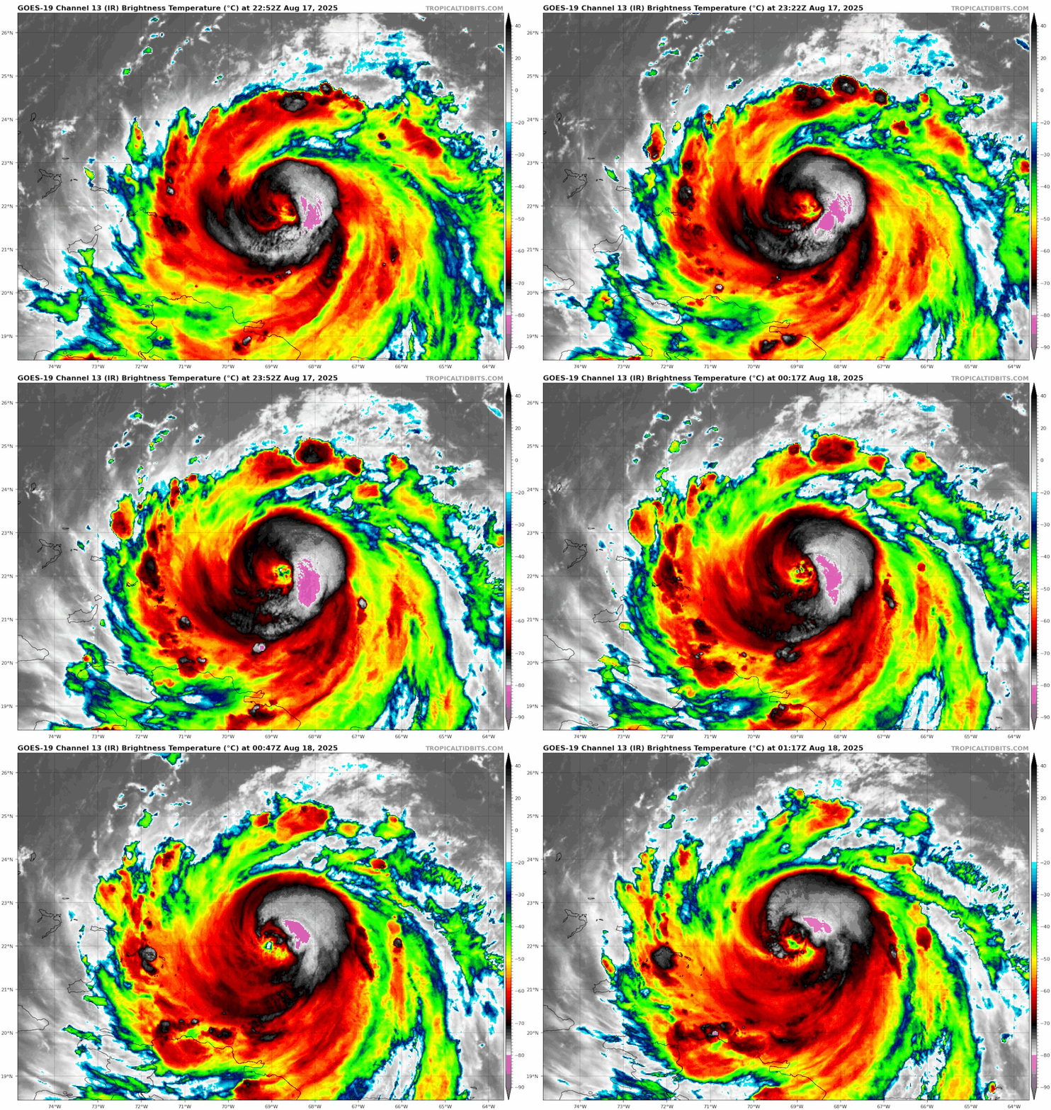
Erin’s starting to clean up pretty good now.
1 likes   

User avatar
Teban54
Category 5
Category 5
Posts: 3247
Joined: Sat May 19, 2018 1:19 pm

Re: ATL: ERIN - Hurricane - Discussion

#886 Postby Teban54 » Sun Aug 17, 2025 8:31 pm

Image
0 likes   

User avatar
MGC
S2K Supporter
S2K Supporter
Posts: 5905
Joined: Sun Mar 23, 2003 9:05 pm
Location: Pass Christian MS, or what is left.

Re: ATL: ERIN - Hurricane - Discussion

#887 Postby MGC » Sun Aug 17, 2025 8:45 pm

Eye starting to open up. Likely waking up to a very large Cat-4 tomorrow. Super lucky it will only disturb the fish.....MGC
6 likes   

hurricaneCW
Category 5
Category 5
Posts: 1795
Joined: Wed Mar 03, 2010 6:20 am
Location: Toms River, NJ

Re: ATL: ERIN - Hurricane - Discussion

#888 Postby hurricaneCW » Sun Aug 17, 2025 9:23 pm

MGC wrote:Eye starting to open up. Likely waking up to a very large Cat-4 tomorrow. Super lucky it will only disturb the fish.....MGC


Yes but there will be a lot of beach erosion, coastal flooding, etc.
0 likes   

User avatar
DW5522
Tropical Depression
Tropical Depression
Posts: 52
Joined: Wed Feb 10, 2021 9:47 pm
Location: Pottsboro

Re: ATL: ERIN - Hurricane - Discussion

#889 Postby DW5522 » Sun Aug 17, 2025 9:23 pm

Hey guys I normally just stick to the winter threads but my brother is leaving for South Carolina Tuesday, what kind of conditions can they expect? Maybe just rain, wind and rough surf?
0 likes   

User avatar
ScottNAtlanta
Category 5
Category 5
Posts: 2420
Joined: Sat May 25, 2013 3:11 pm
Location: Atlanta, GA

Re: ATL: ERIN - Hurricane - Discussion

#890 Postby ScottNAtlanta » Sun Aug 17, 2025 9:23 pm

This is definitely starting to intensify again. There is a ring of very cold cloud tops shooting around the center, and the eye is clearing
2 likes   
The posts in this forum are NOT official forecast and should not be used as such. They are just the opinion of the poster and may or may not be backed by sound meteorological data. They are NOT endorsed by any professional institution or storm2k.org. For official information, please refer to the NHC and NWS products.

emeraldislenc
Category 2
Category 2
Posts: 570
Joined: Fri Aug 24, 2012 4:49 pm
Location: Emerald Isle NC

Re: ATL: ERIN - Hurricane - Discussion

#891 Postby emeraldislenc » Sun Aug 17, 2025 9:31 pm

Hyde county ordered mandatory evacuations of Ocracoke Island, NC! The only way to leave is by ferry. Makes sense to me!
1 likes   

User avatar
sasha_B
Tropical Storm
Tropical Storm
Posts: 126
Age: 24
Joined: Sun Jun 30, 2024 4:32 pm
Location: Charleston, SC

Re: ATL: ERIN - Hurricane - Discussion

#892 Postby sasha_B » Sun Aug 17, 2025 9:56 pm

Back to a Category 4 (115 kts, 942 hPa) on the 03z advisory. Coming along pretty quickly now.
1 likes   

Sciencerocks
Category 5
Category 5
Posts: 9307
Age: 39
Joined: Thu Jul 06, 2017 1:51 am

Re: ATL: ERIN - Hurricane - Discussion

#893 Postby Sciencerocks » Sun Aug 17, 2025 9:58 pm

Image
2 likes   

MarioProtVI
Category 4
Category 4
Posts: 947
Age: 24
Joined: Sun Sep 29, 2019 7:33 pm
Location: New Jersey

Re: ATL: ERIN - Hurricane - Discussion

#894 Postby MarioProtVI » Sun Aug 17, 2025 10:03 pm

sasha_B wrote:Back to a Category 4 (115 kts, 942 hPa) on the 03z advisory. Coming along pretty quickly now.

Recon just disproved this with at most 95 kt support in the SE quad and 956 XTRAP so far (not at the center). Would’ve left it at 110 kt.
1 likes   

User avatar
canebeard
Tropical Storm
Tropical Storm
Posts: 105
Joined: Sun Jul 05, 2009 4:06 pm
Contact:

Re: ATL: ERIN - Hurricane - Discussion

#895 Postby canebeard » Sun Aug 17, 2025 10:04 pm

Jr0d wrote:
OuterBanker wrote: I can't say the same about the Monroe County, Florida Keys officials and their decisions the past 5 years. We have had some close calls but fortunately we haven't had a major impact since Irma, however Ian did cause significant storm surge flooding with tropical storm conditions and they did not evacuate tourists nor declare a state of emergency which made it much more difficult with for those who got flooded to get FEMA aid like a hotel voucher for those who got flooded.

I am glad to see the Dare Country officials are putting public safety over the tourism dollar and hopefully setting up their residents for getting FEMA help as soon as possible if they need it.


A. Monroe County (the Florida Keys) was in the best of hands for decades when Billy Wagner was at the helm. Billy was the man who also sat at the NHC when any hurricane was making landfall in the USA, and coordinating with Emergency Managers in all the threatened areas. (Liaison). Since he retired: ???????

B. The US gov't took three days to even dispatch FEMA personnel to the Hill Country of Texas. The "Secretary" said she can't allocate funds until 72 hours has passed since a request is made for assistance. So good luck with any timely FEMA help in the near future.
3 likes   
List of 79 tropical cyclones intercepted by Richard Horodner:
http://www.canebeard.com/page/page/572246.htm
former storm2k screenname Beoumont 2009+

User avatar
canebeard
Tropical Storm
Tropical Storm
Posts: 105
Joined: Sun Jul 05, 2009 4:06 pm
Contact:

Re: ATL: ERIN - Hurricane - Discussion

#896 Postby canebeard » Sun Aug 17, 2025 10:10 pm

duplicate, please delete, I don't know how
Last edited by canebeard on Sun Aug 17, 2025 11:28 pm, edited 2 times in total.
0 likes   
List of 79 tropical cyclones intercepted by Richard Horodner:
http://www.canebeard.com/page/page/572246.htm
former storm2k screenname Beoumont 2009+

ljmac75
Tropical Storm
Tropical Storm
Posts: 142
Joined: Fri Apr 28, 2023 12:30 am

Re: ATL: ERIN - Hurricane - Discussion

#897 Postby ljmac75 » Sun Aug 17, 2025 10:36 pm

MarioProtVI wrote:
sasha_B wrote:Back to a Category 4 (115 kts, 942 hPa) on the 03z advisory. Coming along pretty quickly now.

Recon just disproved this with at most 95 kt support in the SE quad and 956 XTRAP so far (not at the center). Would’ve left it at 110 kt.


948 (generously 947) pressure. Maybe we'll see a special "Oops" advisory.
0 likes   

User avatar
mitchell
Category 1
Category 1
Posts: 414
Joined: Wed Mar 19, 2003 8:22 am
Location: Delaware
Contact:

Re: ATL: ERIN - Hurricane - Discussion

#898 Postby mitchell » Sun Aug 17, 2025 10:41 pm

DW5522 wrote:Hey guys I normally just stick to the winter threads but my brother is leaving for South Carolina Tuesday, what kind of conditions can they expect? Maybe just rain, wind and rough surf?

rough surf, but SC seems far enough west to avoid any rain or wind from Erin.
0 likes   

User avatar
DW5522
Tropical Depression
Tropical Depression
Posts: 52
Joined: Wed Feb 10, 2021 9:47 pm
Location: Pottsboro

Re: ATL: ERIN - Hurricane - Discussion

#899 Postby DW5522 » Sun Aug 17, 2025 10:52 pm

mitchell wrote:
DW5522 wrote:Hey guys I normally just stick to the winter threads but my brother is leaving for South Carolina Tuesday, what kind of conditions can they expect? Maybe just rain, wind and rough surf?

rough surf, but SC seems far enough west to avoid any rain or wind from Erin.

Thanks bud, appreciate the feedback. I don’t get much hurricane action in north Tx, a little out of my wheelhouse.
0 likes   

HurricaneIrma
Tropical Low
Tropical Low
Posts: 43
Age: 44
Joined: Mon Sep 03, 2018 9:37 am
Location: Wilmington NC

Re: ATL: ERIN - Hurricane - Discussion

#900 Postby HurricaneIrma » Sun Aug 17, 2025 11:55 pm

Is it just me or does it look like as of 1:00 a.m. this morning that the eye of hurricane Erin is starting to move or wobble and a due Westerly direction again
0 likes   


Return to “Active Storms/Invests - Atlantic/EastPAC/CentralPAC/MED”

Who is online

Users browsing this forum: No registered users and 69 guests