2025 Global Model Runs Discussion (Out thru day 16)

This is the general tropical discussion area. Anyone can take their shot at predicting a storms path.

Moderator: S2k Moderators

Forum rules

The posts in this forum are NOT official forecasts and should not be used as such. They are just the opinion of the poster and may or may not be backed by sound meteorological data. They are NOT endorsed by any professional institution or STORM2K. For official information, please refer to products from the National Hurricane Center and National Weather Service.

Help Support Storm2K
Message
Author
Pelicane
Tropical Storm
Tropical Storm
Posts: 190
Joined: Tue Sep 13, 2022 1:52 pm
Location: Lafayette, Louisiana

Re: 2025 Global Model Runs Discussion (Out thru day 16)

#841 Postby Pelicane » Thu Sep 04, 2025 11:34 am

Cpv17 wrote:
TomballEd wrote:
Cpv17 wrote:
I think you’re missing the point.


What did I miss? The brewing in the Gulf does not yield a pot of tropical coffee.


The point is that just about the entire Gulf will be at least somewhat favorable for development beginning mid month.


Right on cue, the GFS has something trying to form in the WCAR in around 8-10 days.
4 likes   

TomballEd
Category 5
Category 5
Posts: 1073
Age: 61
Joined: Wed Aug 16, 2023 4:52 pm
Location: Spring/Klein area, not Tomball

Re: 2025 Global Model Runs Discussion (Out thru day 16)

#842 Postby TomballEd » Thu Sep 04, 2025 12:52 pm

Pelicane wrote:
Cpv17 wrote:
TomballEd wrote:

What did I miss? The brewing in the Gulf does not yield a pot of tropical coffee.


The point is that just about the entire Gulf will be at least somewhat favorable for development beginning mid month.


Right on cue, the GFS has something trying to form in the WCAR in around 8-10 days.


1008 mb depression for Florida. 12Z GFS members are a little better as far as members, there is even a Lake Charles/Cameron landfall perturbation. I view ensembles beyond 10 days for entertainment purposes.
2 likes   

LAF92
Tropical Storm
Tropical Storm
Posts: 134
Joined: Fri Aug 18, 2023 6:27 pm

Re: 2025 Global Model Runs Discussion (Out thru day 16)

#843 Postby LAF92 » Thu Sep 04, 2025 12:53 pm

12z GEFS has a stronger signal that the last few runs. Funny enough it might have a stronger signal than future Gabbriel in the Caribbean
0 likes   

Stratton23
Category 5
Category 5
Posts: 2872
Joined: Fri Jul 21, 2023 10:59 pm
Location: Katy, Tx

Re: 2025 Global Model Runs Discussion (Out thru day 16)

#844 Postby Stratton23 » Thu Sep 04, 2025 2:23 pm

Might have to watch that area of convection to the SW of 91L , seems like some ensemble members are picking up on that developing in the western caribbean in 9-10 days, far out and a pretty low signal, but worth keeping a lazy eye on for sure lol
0 likes   

zzzh
Category 5
Category 5
Posts: 1026
Joined: Thu Sep 02, 2021 1:13 pm

Re: 2025 Global Model Runs Discussion (Out thru day 16)

#845 Postby zzzh » Thu Sep 04, 2025 3:26 pm

Stratton23 wrote:Might have to watch that area of convection to the SW of 91L , seems like some ensemble members are picking up on that developing in the western caribbean in 9-10 days, far out and a pretty low signal, but worth keeping a lazy eye on for sure lol

100%. It actually has a way better structure than 91L. A closed circulation with plenty of convection.
Image
2 likes   

zzzh
Category 5
Category 5
Posts: 1026
Joined: Thu Sep 02, 2021 1:13 pm

Re: 2025 Global Model Runs Discussion (Out thru day 16)

#846 Postby zzzh » Thu Sep 04, 2025 3:33 pm

:uarrow: Monsoon trough break downs are tricky to forecast. I remember no models showed Franklin'23 developing until about 2~3 days before it reached TS intensity. It should be noted that Franklin was also in the western edge of the monsoon trough.
2 likes   

User avatar
Teban54
Category 5
Category 5
Posts: 3761
Joined: Sat May 19, 2018 1:19 pm

Re: 2025 Global Model Runs Discussion (Out thru day 16)

#847 Postby Teban54 » Thu Sep 04, 2025 3:54 pm

zzzh wrote:
Stratton23 wrote:Might have to watch that area of convection to the SW of 91L , seems like some ensemble members are picking up on that developing in the western caribbean in 9-10 days, far out and a pretty low signal, but worth keeping a lazy eye on for sure lol

100%. It actually has a way better structure than 91L. A closed circulation with plenty of convection.
https://i.imgur.com/k0wujU7.png

zzzh wrote::uarrow: Monsoon trough break downs are tricky to forecast. I remember no models showed Franklin'23 developing until about 2~3 days before it reached TS intensity. It should be noted that Franklin was also in the western edge of the monsoon trough.

I made a new post for this area, with some more discussions of how it was portrayed in the 12z model runs.
1 likes   

User avatar
Teban54
Category 5
Category 5
Posts: 3761
Joined: Sat May 19, 2018 1:19 pm

Re: 2025 Global Model Runs Discussion (Out thru day 16)

#848 Postby Teban54 » Thu Sep 04, 2025 7:26 pm

18z GFS brings back the MDR storm behind 91L, but it takes one of the most bizarre tracks that I've seen (even for a fantasy-range storm). Lifts almost due north to 22N, only to do the classic WSW dive towards the islands.

Image
4 likes   

LarryWx
S2K Supporter
S2K Supporter
Posts: 6853
Joined: Sun Sep 07, 2003 2:04 pm
Location: GA

Re: 2025 Global Model Runs Discussion (Out thru day 16)

#849 Postby LarryWx » Fri Sep 05, 2025 6:44 am

From something well to the W of 91L coming out of the Caribbean in 6-7 days, the 6Z GEFS is pretty active mainly in the Gulf with a couple E of FL. Some of these members are hurricanes.

*Edit: The GEFS/EPS of the last few days have had the MJO then in or near the most dangerous phase for July-Sept CONUS H hits, phase 2.

Edit: 6Z GEFS suggests there could be another TC coming out of the W Caribbean later.
1 likes   
Personal Forecast Disclaimer:
The posts in this forum are NOT official forecasts and should not be used as such. They are just the opinion of the poster and may or may not be backed by sound meteorological data. They are NOT endorsed by any professional institution or storm2k.org. For official information, please refer to the NHC and NWS products.

TomballEd
Category 5
Category 5
Posts: 1073
Age: 61
Joined: Wed Aug 16, 2023 4:52 pm
Location: Spring/Klein area, not Tomball

Re: 2025 Global Model Runs Discussion (Out thru day 16)

#850 Postby TomballEd » Fri Sep 05, 2025 9:52 am

LarryWx wrote:From something well to the W of 91L coming out of the Caribbean in 6-7 days, the 6Z GEFS is pretty active mainly in the Gulf with a couple E of FL. Some of these members are hurricanes.

*Edit: The GEFS/EPS of the last few days have had the MJO then in or near the most dangerous phase for July-Sept CONUS H hits, phase 2.

Edit: 6Z GEFS suggests there could be another TC coming out of the W Caribbean later.


Looking at the op, the attempt as TCG in the Gulf is thwarted by a Pacific system that develops first. I'm assuming the members showing a storm develop the EPac system farther W or even earlier, or maybe not at all.
2 likes   

Stratton23
Category 5
Category 5
Posts: 2872
Joined: Fri Jul 21, 2023 10:59 pm
Location: Katy, Tx

Re: 2025 Global Model Runs Discussion (Out thru day 16)

#851 Postby Stratton23 » Fri Sep 05, 2025 12:34 pm

Still a CAG signal on the GEFS, a couple of really strong members in the gulf around day 9-10 ish
2 likes   

User avatar
Category5Kaiju
Category 5
Category 5
Posts: 4285
Joined: Thu Dec 24, 2020 12:45 pm
Location: Seattle and Phoenix

Re: 2025 Global Model Runs Discussion (Out thru day 16)

#852 Postby Category5Kaiju » Fri Sep 05, 2025 1:16 pm

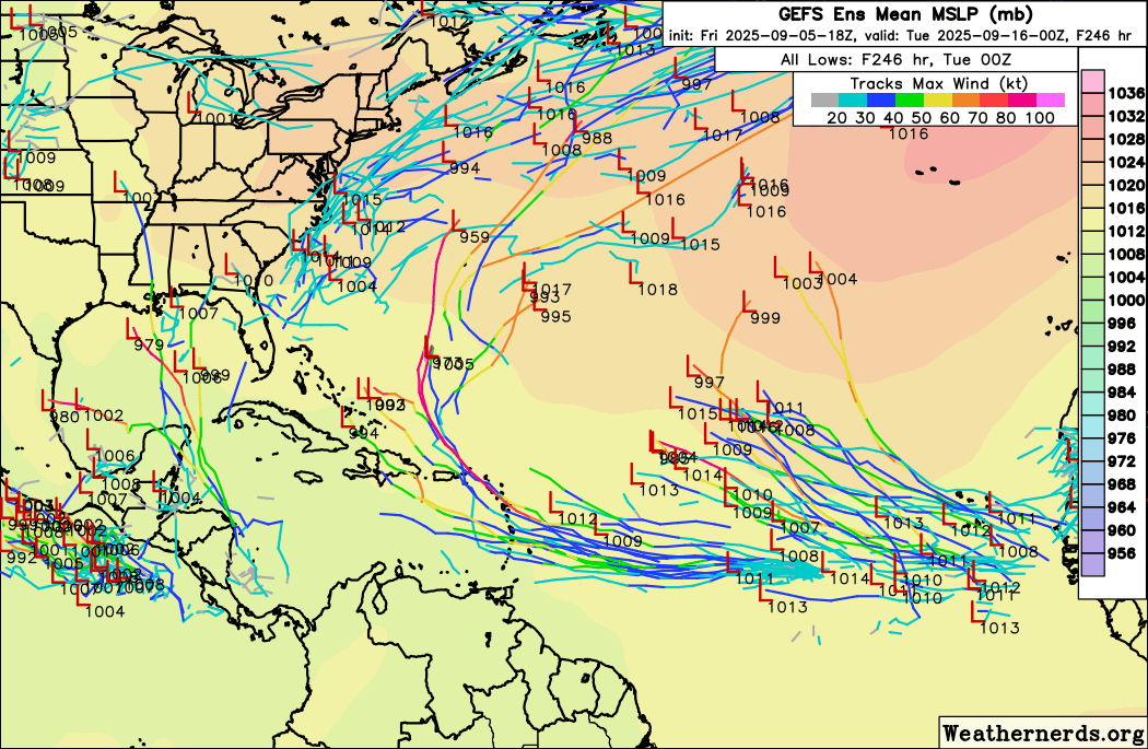
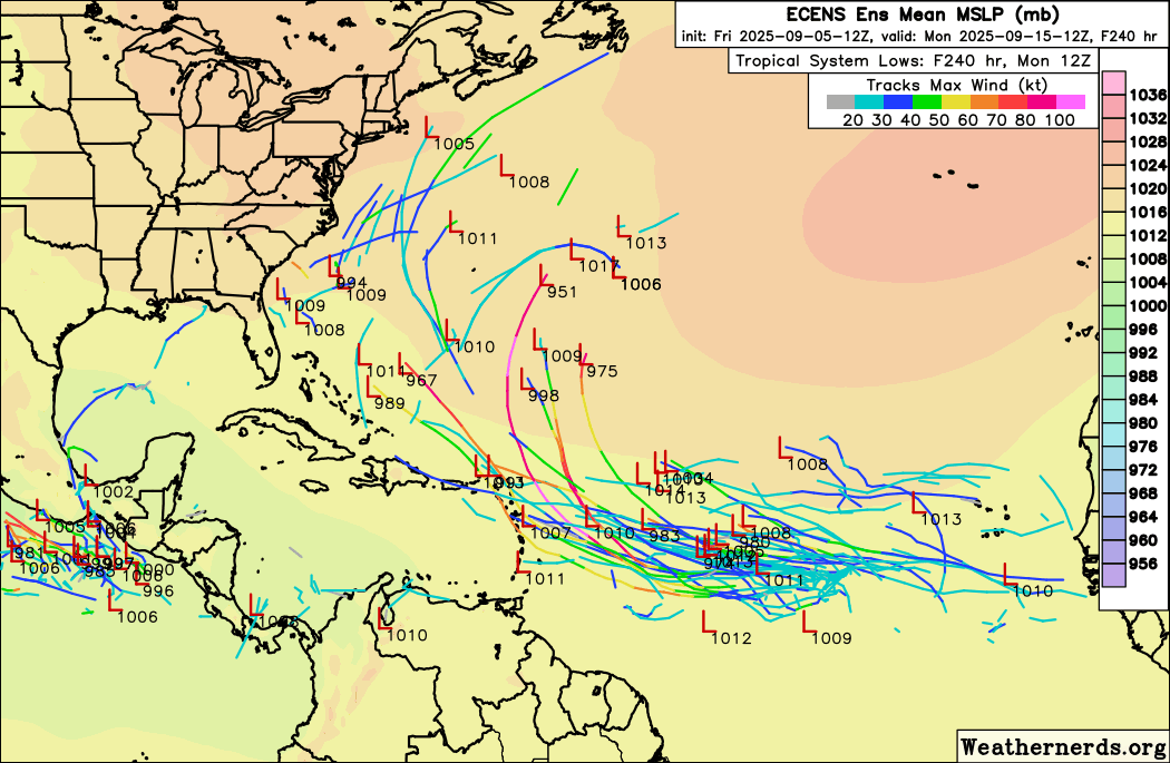
For what it’s worth, the latest GEFS ensembles show an explosion of MDR activity around the September 15 timeframe, as well as a few strong members in the Gulf, which would also be on par with the upcoming predicted favorable phase of the MJO.

I will admit, the 91L bust made me realize that perhaps the background state right now simply isn’t conducive for deep tropical activity. At least not yet.

But we still have 25 days left this month, and seasons with a quiet/dead climatological peak season and activity ramping up in mid-late September are not unheard of, especially as of recently. I don’t see how or why 2025 would not be able to accomplish something like this, especially when instability rises during the fall and after literally generating a powerhouse Category 5 hurricane in August.
5 likes   
Unless explicitly stated, all info in my posts is based on my own opinions and observations. Tropical storms and hurricanes can be extremely dangerous. Refer to an accredited weather research agency or meteorologist if you need to make serious decisions regarding an approaching storm.

Stratton23
Category 5
Category 5
Posts: 2872
Joined: Fri Jul 21, 2023 10:59 pm
Location: Katy, Tx

Re: 2025 Global Model Runs Discussion (Out thru day 16)

#853 Postby Stratton23 » Fri Sep 05, 2025 2:18 pm

EPS kind of hints at what the GEFS is showing in the western half of the basin, in the 10-12 day range, but with the MJO going into 1/2 and potentially stalling in those phases, I wouldnt be the least bit surprised to see a signal for the western caribbean/ grow in the coming days, those phases typically favor US landfalls , and id argue it favora more chances for gulf/ w. caribbean activity in relation to the CAG
0 likes   

User avatar
Hurricaneman
Category 5
Category 5
Posts: 7404
Age: 45
Joined: Tue Aug 31, 2004 3:24 pm
Location: central florida

Re: 2025 Global Model Runs Discussion (Out thru day 16)

#854 Postby Hurricaneman » Fri Sep 05, 2025 2:55 pm

zzzh wrote:
Stratton23 wrote:Might have to watch that area of convection to the SW of 91L , seems like some ensemble members are picking up on that developing in the western caribbean in 9-10 days, far out and a pretty low signal, but worth keeping a lazy eye on for sure lol

100%. It actually has a way better structure than 91L. A closed circulation with plenty of convection.
https://i.imgur.com/k0wujU7.png


Wouldn’t be surprised if models drop 91L for this feature but the area at 25W is interesting as there is turning there too, that could be an unmodeled sleeper
0 likes   

User avatar
Teban54
Category 5
Category 5
Posts: 3761
Joined: Sat May 19, 2018 1:19 pm

Re: 2025 Global Model Runs Discussion (Out thru day 16)

#855 Postby Teban54 » Fri Sep 05, 2025 7:33 pm

I know that "the next wave" is crying wolf now, but FWIW, 18z GEFS shows pretty good support in the Eastern Atlantic:

Image

EPS has the wave much further south in the MDR. Much weaker support, but still shows some developing members (and the previous 0z run had even more):

Image
0 likes   

Stratton23
Category 5
Category 5
Posts: 2872
Joined: Fri Jul 21, 2023 10:59 pm
Location: Katy, Tx

Re: 2025 Global Model Runs Discussion (Out thru day 16)

#856 Postby Stratton23 » Fri Sep 05, 2025 11:31 pm

GFS continues to show development in the western caribbean in 7 days, trough cuts off from the east coast and moves into the gulf, interacts with some energy in the western caribbean and pops off low pressure
0 likes   

LAF92
Tropical Storm
Tropical Storm
Posts: 134
Joined: Fri Aug 18, 2023 6:27 pm

Re: 2025 Global Model Runs Discussion (Out thru day 16)

#857 Postby LAF92 » Fri Sep 05, 2025 11:35 pm

Alot of moisture in the gulf around day 7 on the GFS. I think the odds of seeing something develop should continue to increase.
0 likes   

User avatar
Category5Kaiju
Category 5
Category 5
Posts: 4285
Joined: Thu Dec 24, 2020 12:45 pm
Location: Seattle and Phoenix

Re: 2025 Global Model Runs Discussion (Out thru day 16)

#858 Postby Category5Kaiju » Sat Sep 06, 2025 12:16 am

Recent GEFS ensembles seem excited about a possible system in the Gulf and an MDR system by the September 12-14 timeframe. Will this be a legit signal unlike 91L and be the beginning of a switch flip? We shall see.
0 likes   
Unless explicitly stated, all info in my posts is based on my own opinions and observations. Tropical storms and hurricanes can be extremely dangerous. Refer to an accredited weather research agency or meteorologist if you need to make serious decisions regarding an approaching storm.

Stratton23
Category 5
Category 5
Posts: 2872
Joined: Fri Jul 21, 2023 10:59 pm
Location: Katy, Tx

Re: 2025 Global Model Runs Discussion (Out thru day 16)

#859 Postby Stratton23 » Sat Sep 06, 2025 12:18 am

GEFS with a noticeable increase in a signal for development in the NW caribbean or gulf around the 12-14th of september, which perfectly lines up with the MJO moving into the atlantic basin by then, ill admit im growing intrigued in this possibility
1 likes   

LAF92
Tropical Storm
Tropical Storm
Posts: 134
Joined: Fri Aug 18, 2023 6:27 pm

Re: 2025 Global Model Runs Discussion (Out thru day 16)

#860 Postby LAF92 » Sat Sep 06, 2025 12:32 am

One of the strongest signals from the GEFS in a while for the 7-10 day period.
0 likes   


Return to “Talkin' Tropics”

Who is online

Users browsing this forum: kevin and 70 guests