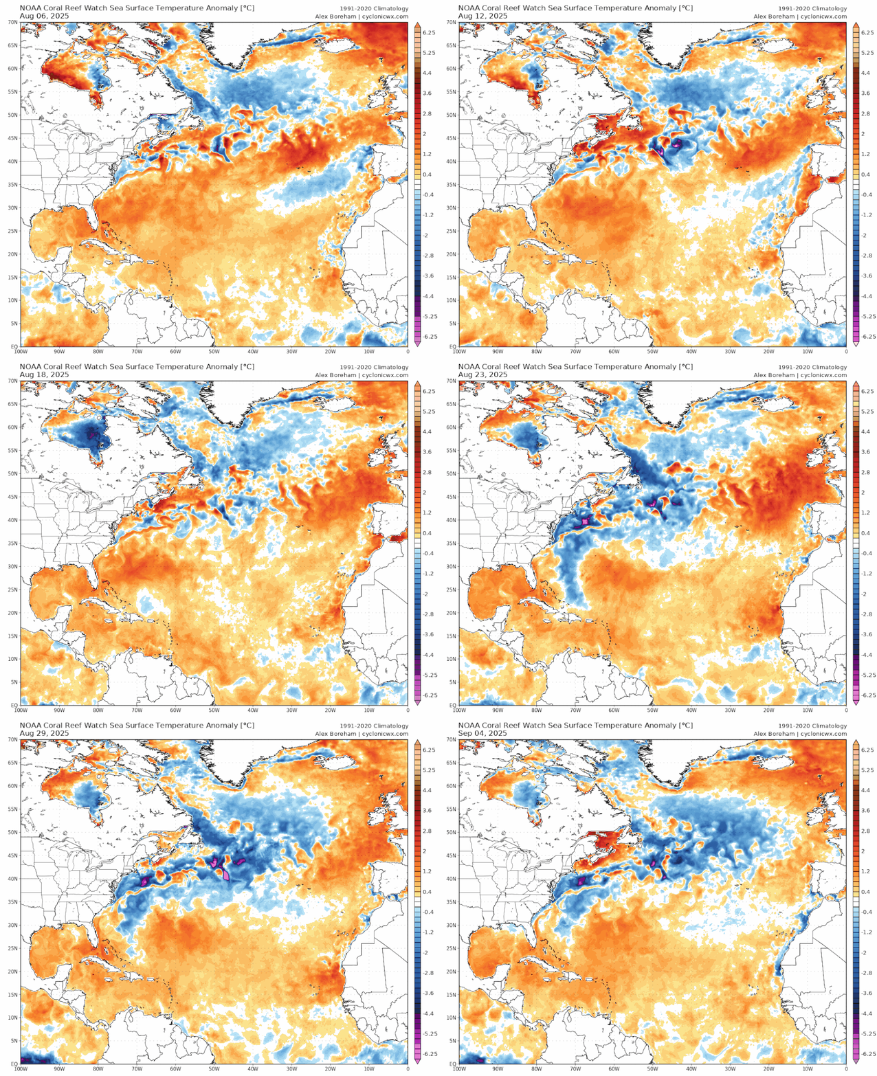
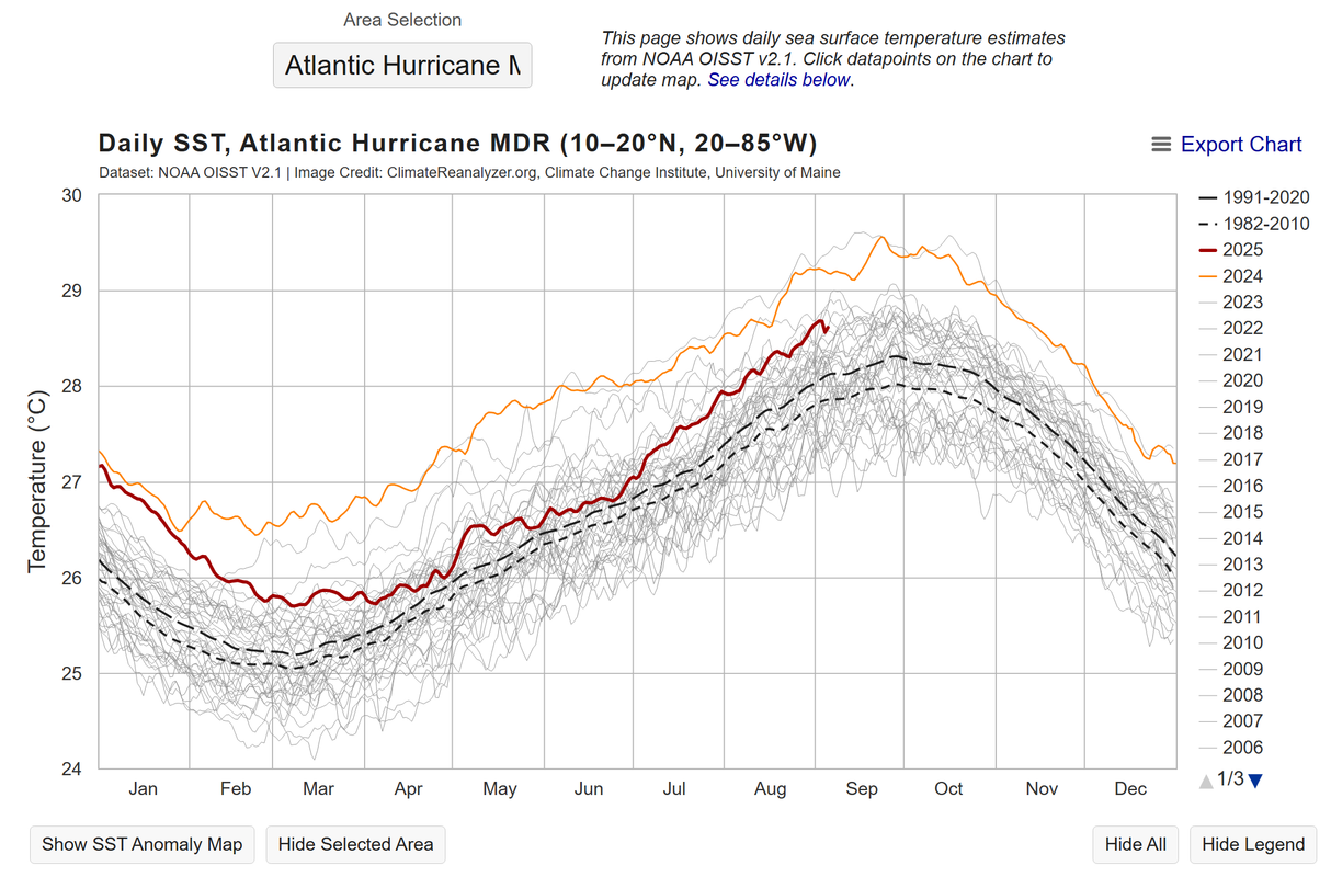
2025 Indicators: SST's, MSLP, Shear, SAL, Steering, Instability (Day 16+ Climate Models)

This is the general tropical discussion area. Anyone can take their shot at predicting a storms path.

Moderator: S2k Moderators

Forum rules

The posts in this forum are NOT official forecasts and should not be used as such. They are just the opinion of the poster and may or may not be backed by sound meteorological data. They are NOT endorsed by any professional institution or STORM2K. For official information, please refer to products from the National Hurricane Center and National Weather Service.

Help Support Storm2K
Message
Author
LarryWx
S2K Supporter
S2K Supporter
Posts: 6556
Joined: Sun Sep 07, 2003 2:04 pm
Location: GA

Re: 2025 Indicators: SST's, MSLP, Shear, SAL, Steering, Instability (Day 16+ Climate Models)

#581 Postby LarryWx » Fri Sep 05, 2025 12:33 pm

CyclonicFury wrote:While I still expect activity to pick up in the back of half of September, there's an increasing chance we go the entire first 10 days (or perhaps longer) of September without a single tropical cyclone. That has to be extremely rare. Two years in a row, we've seen an uncharacteristic lull near the peak of the season. Unlike last year though, we've seen practically no Gulf activity except the weak, short-lived Barry in late June. Erin has been the only hurricane so far. 2025 is on pace to have the latest second hurricane in the NATL since 2013.


Regarding the current active era seasons with no El Niño:
-In 2024, there were 0 TCs during the 19 days 8/21-9/8.
-In 2022, there were 0 TCs in August.
-In 2016, there were 0 TCs Sep 4-11 and 0 H Sep 3-28.
-In 2013, there was no H til 9/11.
-In 2001, there was no H til 9/8
1 likes   
Personal Forecast Disclaimer:
The posts in this forum are NOT official forecasts and should not be used as such. They are just the opinion of the poster and may or may not be backed by sound meteorological data. They are NOT endorsed by any professional institution or storm2k.org. For official information, please refer to the NHC and NWS products.

WeatherBoy2000
Category 1
Category 1
Posts: 416
Joined: Mon Apr 10, 2023 9:29 am

Re: 2025 Indicators: SST's, MSLP, Shear, SAL, Steering, Instability (Day 16+ Climate Models)

#582 Postby WeatherBoy2000 » Fri Sep 05, 2025 1:25 pm

LarryWx wrote:
CyclonicFury wrote:While I still expect activity to pick up in the back of half of September, there's an increasing chance we go the entire first 10 days (or perhaps longer) of September without a single tropical cyclone. That has to be extremely rare. Two years in a row, we've seen an uncharacteristic lull near the peak of the season. Unlike last year though, we've seen practically no Gulf activity except the weak, short-lived Barry in late June. Erin has been the only hurricane so far. 2025 is on pace to have the latest second hurricane in the NATL since 2013.


Regarding the current active era seasons with no El Niño:
-In 2024, there were 0 TCs during the 19 days 8/21-9/8.
-In 2022, there were 0 TCs in August.
-In 2016, there were 0 TCs Sep 4-11 and 0 H Sep 3-28.
-In 2013, there was no H til 9/11.
-In 2001, there was no H til 9/8


Except for 2013, all those seasons had at least relatively busy late seasons.
3 likes   

User avatar
aspen
Category 5
Category 5
Posts: 8867
Joined: Sat Oct 12, 2019 7:10 pm
Location: Connecticut, USA

Re: 2025 Indicators: SST's, MSLP, Shear, SAL, Steering, Instability (Day 16+ Climate Models)

#583 Postby aspen » Fri Sep 05, 2025 5:05 pm

CyclonicFury wrote:While I still expect activity to pick up in the back of half of September, there's an increasing chance we go the entire first 10 days (or perhaps longer) of September without a single tropical cyclone. That has to be extremely rare. Two years in a row, we've seen an uncharacteristic lull near the peak of the season. Unlike last year though, we've seen practically no Gulf activity except the weak, short-lived Barry in late June. Erin has been the only hurricane so far. 2025 is on pace to have the latest second hurricane in the NATL since 2013.

Either Erin was a freak anomaly and not representative of what peak season has in store (what we all thought Beryl was during the 2024 lull), or we’re going to have yet another delayed peak. 2024-levels of activity are likely off the table even if the latter happens.

I’m thinking we could end the season with 2022 numbers. Which is kind of what I suspected early on seeing the lukewarm to slightly unfavorable indicators — relatively tame SSTAs, unenthusiastic CanSIPS precipitation forecasts, etc. It didn’t seem like we were looking at another 15+ NS, >120-140 ACE season.
1 likes   
Irene '11 Sandy '12 Hermine '16 5/15/2018 Derecho Fay '20 Isaias '20 Elsa '21 Henri '21 Ida '21

I am only a meteorology enthusiast who knows a decent amount about tropical cyclones. Look to the professional mets, the NHC, or your local weather office for the best information.

User avatar
StormWeather
Category 1
Category 1
Posts: 336
Joined: Wed Jun 05, 2024 2:34 pm

Re: 2025 Indicators: SST's, MSLP, Shear, SAL, Steering, Instability (Day 16+ Climate Models)

#584 Postby StormWeather » Fri Sep 05, 2025 5:31 pm

aspen wrote:
CyclonicFury wrote:While I still expect activity to pick up in the back of half of September, there's an increasing chance we go the entire first 10 days (or perhaps longer) of September without a single tropical cyclone. That has to be extremely rare. Two years in a row, we've seen an uncharacteristic lull near the peak of the season. Unlike last year though, we've seen practically no Gulf activity except the weak, short-lived Barry in late June. Erin has been the only hurricane so far. 2025 is on pace to have the latest second hurricane in the NATL since 2013.

Either Erin was a freak anomaly and not representative of what peak season has in store (what we all thought Beryl was during the 2024 lull), or we’re going to have yet another delayed peak. 2024-levels of activity are likely off the table even if the latter happens.

I’m thinking we could end the season with 2022 numbers. Which is kind of what I suspected early on seeing the lukewarm to slightly unfavorable indicators — relatively tame SSTAs, unenthusiastic CanSIPS precipitation forecasts, etc. It didn’t seem like we were looking at another 15+ NS, >120-140 ACE season.

It sounds impossible after facing 10 straight years of average (2022) to above average (2016, 2017, 2018, 2019, 2020, 2021, 2023 and 2024) that we could see our first below average season since 2014, and that strikes me as odd.
1 likes   
Just an average cyclone tracker

The posts in this forum are NOT official forecasts and should not be used as such. They are just the opinion of the poster and may or may not be backed by sound meteorological data. They are NOT endorsed by any professional institution or storm2k.org. For official information, please refer to the NHC and NWS products

User avatar
REDHurricane
Category 1
Category 1
Posts: 416
Age: 28
Joined: Sun Jul 03, 2022 2:36 pm
Location: Northeast Pacific Ocean

Re: 2025 Indicators: SST's, MSLP, Shear, SAL, Steering, Instability (Day 16+ Climate Models)

#585 Postby REDHurricane » Fri Sep 05, 2025 9:06 pm

StormWeather wrote:
aspen wrote:
CyclonicFury wrote:While I still expect activity to pick up in the back of half of September, there's an increasing chance we go the entire first 10 days (or perhaps longer) of September without a single tropical cyclone. That has to be extremely rare. Two years in a row, we've seen an uncharacteristic lull near the peak of the season. Unlike last year though, we've seen practically no Gulf activity except the weak, short-lived Barry in late June. Erin has been the only hurricane so far. 2025 is on pace to have the latest second hurricane in the NATL since 2013.

Either Erin was a freak anomaly and not representative of what peak season has in store (what we all thought Beryl was during the 2024 lull), or we’re going to have yet another delayed peak. 2024-levels of activity are likely off the table even if the latter happens.

I’m thinking we could end the season with 2022 numbers. Which is kind of what I suspected early on seeing the lukewarm to slightly unfavorable indicators — relatively tame SSTAs, unenthusiastic CanSIPS precipitation forecasts, etc. It didn’t seem like we were looking at another 15+ NS, >120-140 ACE season.

It sounds impossible after facing 10 straight years of average (2022) to above average (2016, 2017, 2018, 2019, 2020, 2021, 2023 and 2024) that we could see our first below average season since 2014, and that strikes me as odd.


There's absolutely no way that this season will end up below average, and I'd be willing to bet money on it if I cared enough -- it's September 5th, the Atlantic is only ~8 ACE below average, and the scene looks like this:

Image

Yeah no, I'd say there's still a better chance that this season will reach 200 ACE than fall below the long-term average of ~125 ACE. I'll happily eat my crow if I'm wrong, but I really don't see how this current SST setup results in anything other than an above-average season -- sure, SSTs are only one part of the equation, but we have more than a century of data to very strongly suggest that the next 2.5 months in a La Niña/+AMO/tropics solidly above average/subtropics near average Atlantic background state will produce a high amount of tropical activity. Way too early to even think about starting the "season cancel" musings in my humble opinion; at this point that only serves to tempt fate.
6 likes   

User avatar
StormWeather
Category 1
Category 1
Posts: 336
Joined: Wed Jun 05, 2024 2:34 pm

Re: 2025 Indicators: SST's, MSLP, Shear, SAL, Steering, Instability (Day 16+ Climate Models)

#586 Postby StormWeather » Fri Sep 05, 2025 9:16 pm

REDHurricane wrote:
StormWeather wrote:
aspen wrote:Either Erin was a freak anomaly and not representative of what peak season has in store (what we all thought Beryl was during the 2024 lull), or we’re going to have yet another delayed peak. 2024-levels of activity are likely off the table even if the latter happens.

I’m thinking we could end the season with 2022 numbers. Which is kind of what I suspected early on seeing the lukewarm to slightly unfavorable indicators — relatively tame SSTAs, unenthusiastic CanSIPS precipitation forecasts, etc. It didn’t seem like we were looking at another 15+ NS, >120-140 ACE season.

It sounds impossible after facing 10 straight years of average (2022) to above average (2016, 2017, 2018, 2019, 2020, 2021, 2023 and 2024) that we could see our first below average season since 2014, and that strikes me as odd.


There's absolutely no way that this season will end up below average, and I'd be willing to bet money on it if I cared enough -- it's September 5th, the Atlantic is only ~8 ACE below average, and the scene looks like this:

https://i.ibb.co/N6gVPNxC/ct5km-ssta-v3-1-global-current.png

Yeah no, I'd say there's still a better chance that this season will reach 200 ACE than fall below the long-term average of ~125 ACE. I'll happily eat my crow if I'm wrong, but I really don't see how this current SST setup results in anything other than an above-average season -- sure, SSTs are only one part of the equation, but we have more than a century of data to very strongly suggest that the next 2.5 months in a La Niña/+AMO/tropics solidly above average/subtropics near average Atlantic background state will produce a high amount of tropical activity. Way too early to even think about starting the "season cancel" musings in my humble opinion; at this point that only serves to tempt fate.

That definitely looks like a La Niña event trying to form. And the Atlantic subtropics could be cooler, but the correlation is there for an active season. Just have to wait and see I guess.
1 likes   
Just an average cyclone tracker

The posts in this forum are NOT official forecasts and should not be used as such. They are just the opinion of the poster and may or may not be backed by sound meteorological data. They are NOT endorsed by any professional institution or storm2k.org. For official information, please refer to the NHC and NWS products

User avatar
Category5Kaiju
Category 5
Category 5
Posts: 4182
Joined: Thu Dec 24, 2020 12:45 pm
Location: Seattle

Re: 2025 Indicators: SST's, MSLP, Shear, SAL, Steering, Instability (Day 16+ Climate Models)

#587 Postby Category5Kaiju » Fri Sep 05, 2025 11:38 pm

I guess in a certain sense, it would be very natural to watch an invest like 91L (with multiple models consistently showing significant development of the system, only to abruptly drop it even as it reached 60/90% chance of formation per NHC, all during the month of September), and begin to question the season's potential and if there's something strange going on with the basin.

However, in this case I think it would be wise to take a step back and look at the broad picture to have a better understanding of what may be happening. What do we know? Well, we know that the Atlantic currently is in an unfavorable MJO pattern. This has been talked about quite a bit for the past days/weeks since Erin departed the picture. That, or something related, may be the reason why there's so much dry air, shear, and stability/sinking motion associated with the deep tropics and why despite initial model excitement for 91L, there were, retrospectively, red flags for such to really amount to anything huge.

However, what we do know is that the deep tropics are still very warm, the Nino 3-4 region is starting to exhibit signs that it may enter some degree of La Nina or cool neutral for this winter, and a more favorable MJO pulse is expected to enter the basin by mid-month. These are all key ingredients to possibly fueling late season action, and as we've learned from 2022 and 2024, sometimes early September can look radically different from late September. Instability naturally increases as we enter fall can really do wonders to facilitate tropical cyclogenesis.

Also...as I type this, the 00z GFS and CMC are both spitting out another wave into the MDR that looks to become a trackable feature/system around the September 12th timeframe (so basically a week from now). It remains to be seen if this is a phantom or now, but unlike 91L, this theoretical system would actually coincide with the predicted favorable MJO pulse, and by then who knows if whatever negative factors caused 91L's demise are still around....or not? My point in all this is, while 91L's bust was certainly eyebrow-raising, at this point in time, I don't think it was indicative of some larger, underlying problem that will plague the basin for the forseeable future. If we still struggle with producing tropical cyclones throughout this month, then yes I would reconsider my stance on this, but for now I guess our eyes should shift to long-range models for mid-September. As a reminder, even the abysmal 2013 season saw its two hurricanes during September, and the 1914 season saw its only storm during September. We say "September Remember" for a reason. :lol:
2 likes   
Unless explicitly stated, all info in my posts is based on my own opinions and observations. Tropical storms and hurricanes can be extremely dangerous. Do not think you can beat Mother Nature. Refer to an accredited weather research agency or meteorologist if you need to make serious decisions regarding an approaching storm.

AxaltaRacing24
Category 5
Category 5
Posts: 1769
Age: 25
Joined: Wed Jul 27, 2016 11:14 am
Location: Jupiter, FL

Re: 2025 Indicators: SST's, MSLP, Shear, SAL, Steering, Instability (Day 16+ Climate Models)

#588 Postby AxaltaRacing24 » Sat Sep 06, 2025 2:46 am

Category5Kaiju wrote:I guess in a certain sense, it would be very natural to watch an invest like 91L (with multiple models consistently showing significant development of the system, only to abruptly drop it even as it reached 60/90% chance of formation per NHC, all during the month of September), and begin to question the season's potential and if there's something strange going on with the basin.

However, in this case I think it would be wise to take a step back and look at the broad picture to have a better understanding of what may be happening. What do we know? Well, we know that the Atlantic currently is in an unfavorable MJO pattern. This has been talked about quite a bit for the past days/weeks since Erin departed the picture. That, or something related, may be the reason why there's so much dry air, shear, and stability/sinking motion associated with the deep tropics and why despite initial model excitement for 91L, there were, retrospectively, red flags for such to really amount to anything huge.

However, what we do know is that the deep tropics are still very warm, the Nino 3-4 region is starting to exhibit signs that it may enter some degree of La Nina or cool neutral for this winter, and a more favorable MJO pulse is expected to enter the basin by mid-month. These are all key ingredients to possibly fueling late season action, and as we've learned from 2022 and 2024, sometimes early September can look radically different from late September. Instability naturally increases as we enter fall can really do wonders to facilitate tropical cyclogenesis.

Also...as I type this, the 00z GFS and CMC are both spitting out another wave into the MDR that looks to become a trackable feature/system around the September 12th timeframe (so basically a week from now). It remains to be seen if this is a phantom or now, but unlike 91L, this theoretical system would actually coincide with the predicted favorable MJO pulse, and by then who knows if whatever negative factors caused 91L's demise are still around....or not? My point in all this is, while 91L's bust was certainly eyebrow-raising, at this point in time, I don't think it was indicative of some larger, underlying problem that will plague the basin for the foreseeable future. If we still struggle with producing tropical cyclones throughout this month, then yes I would reconsider my stance on this, but for now I guess our eyes should shift to long-range models for mid-September. As a reminder, even the abysmal 2013 season saw its two hurricanes during September, and the 1914 season saw its only storm during September. We say "September Remember" for a reason. :lol:

This is also the same season that just produced a monster cat 5 only weeks ago. This season might end up like 2014 where it is very MJO reliant, meaning that we will get quality canes, but not a high storm total.
0 likes   


Return to “Talkin' Tropics”

Who is online

Users browsing this forum: Hurricane2022, South Texas Storms, Ulf and 106 guests