NATL: INVEST 92L - Discussion (90/90)

Current storms and invests:

Moderators: hurricanetrack, S2k Moderators


The posts in this forum are NOT official forecasts and should not be used as such. They are just the opinion of the poster and may or may not be backed by sound meteorological data. They are NOT endorsed by any professional institution or STORM2K. For official information, please refer to products from the National Hurricane Center and National Weather Service.

Help Support Storm2K
Message
Author
User avatar
Nimbus
Category 5
Category 5
Posts: 5367
Joined: Mon Jul 19, 2004 10:54 am

Re: ATL: INVEST 92L - Discussion (40/80)

#21 Postby Nimbus » Mon Sep 15, 2025 5:33 pm

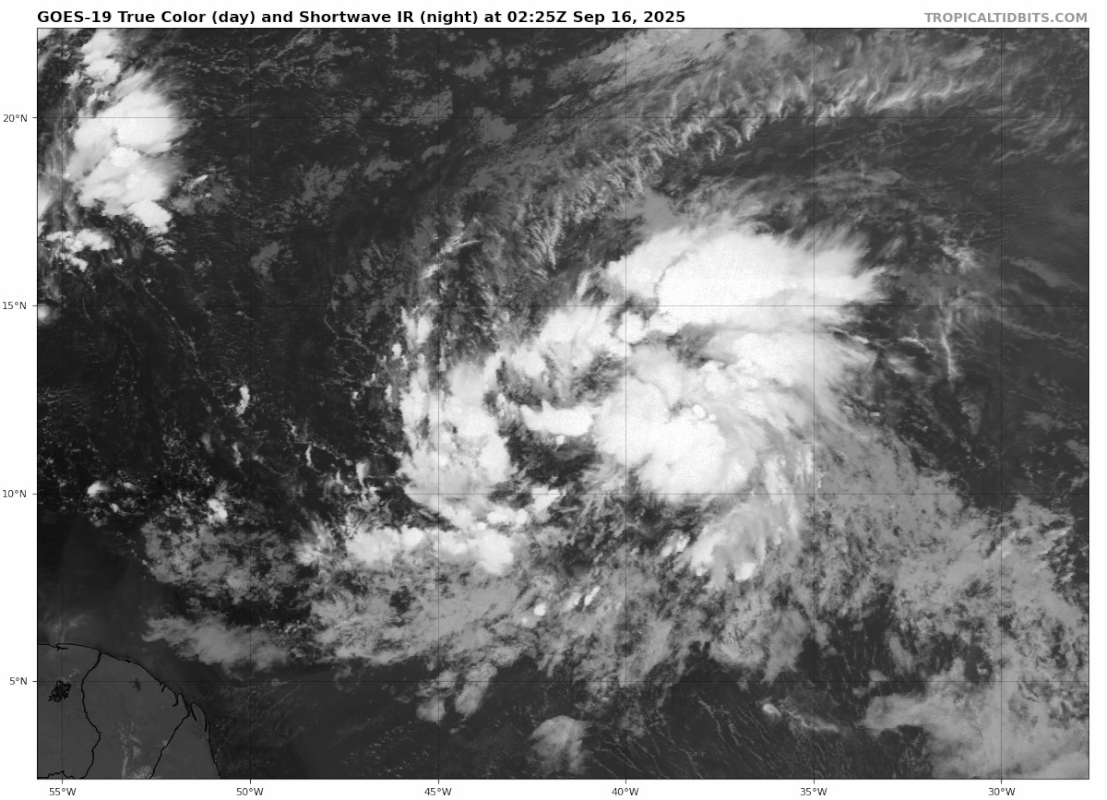
AnnularCane wrote:Part of me is waiting for this one to get past 60/90 (91L's peak). 8-)


Looks like it might close off near 13N which means it could lose its moisture feed from the wave form like 91L.
But its later in the season and the Strat clumps aren't moving as fast so should be interesting to watch.
0 likes   

User avatar
cycloneye
Admin
Admin
Posts: 146699
Age: 69
Joined: Thu Oct 10, 2002 10:54 am
Location: San Juan, Puerto Rico

Re: NATL: INVEST 92L - Discussion (60/90)

#22 Postby cycloneye » Mon Sep 15, 2025 6:35 pm

AnnularCane Tied with 91L. :D

Tropical Weather Outlook
NWS National Hurricane Center Miami FL
800 PM EDT Mon Sep 15 2025

For the North Atlantic...Caribbean Sea and the Gulf of America:

1. Central Tropical Atlantic (AL92):
A broad area of low pressure is located about midway between
the Windward Islands and the coast of west Africa. This system
is showing signs of organization, and is expected to move through a
favorable environment for further development. A tropical
depression or tropical storm is likely to form by the middle to
latter part of this week while the system moves west-northwestward
at 10 to 15 mph over the central tropical Atlantic.
* Formation chance through 48 hours...medium...60 percent.
* Formation chance through 7 days...high...90 percent.


Forecaster Pasch
3 likes   
Visit the Caribbean-Central America Weather Thread where you can find at first post web cams,radars
and observations from Caribbean basin members Click Here

User avatar
AnnularCane
S2K Supporter
S2K Supporter
Posts: 2906
Joined: Thu Jun 08, 2006 9:18 am
Location: Wytheville, VA

Re: NATL: INVEST 92L - Discussion (60/90)

#23 Postby AnnularCane » Mon Sep 15, 2025 6:43 pm

Okay, little 92L. Come on, you can do it! :team:
5 likes   
"But it never rained rain. It never snowed snow. And it never blew just wind. It rained things like soup and juice. It snowed mashed potatoes and green peas. And sometimes the wind blew in storms of hamburgers." -- Judi Barrett, Cloudy with a Chance of Meatballs

User avatar
StormWeather
Category 1
Category 1
Posts: 360
Joined: Wed Jun 05, 2024 2:34 pm

Re: NATL: INVEST 92L - Discussion (60/90)

#24 Postby StormWeather » Mon Sep 15, 2025 6:53 pm

AnnularCane wrote:Okay, little 92L. Come on, you can do it! :team:

Already looking like it could form as soon as tomorrow afternoon or evening with it’s current appearance.
0 likes   
Just an average cyclone tracker

The posts in this forum are NOT official forecasts and should not be used as such. They are just the opinion of the poster and may or may not be backed by sound meteorological data. They are NOT endorsed by any professional institution or storm2k.org. For official information, please refer to the NHC and NWS products

User avatar
WaveBreaking
Category 2
Category 2
Posts: 608
Joined: Sun Jun 30, 2024 11:33 am
Location: US

Re: NATL: INVEST 92L - Discussion (60/90)

#25 Postby WaveBreaking » Mon Sep 15, 2025 7:28 pm

Made my own True Color image of 92L from a little earlier today using the Red, Blue, and Veggie GOES bands. I was thinking about posting a tutorial on how to make these images :D


Image
Last edited by WaveBreaking on Mon Sep 15, 2025 7:31 pm, edited 1 time in total.
3 likes   
I am NOT a professional meteorologist, so take all of my posts with a grain of salt. My opinions are mine and mine alone.

User avatar
cycloneye
Admin
Admin
Posts: 146699
Age: 69
Joined: Thu Oct 10, 2002 10:54 am
Location: San Juan, Puerto Rico

Re: NATL: INVEST 92L - Discussion (60/90)

#26 Postby cycloneye » Mon Sep 15, 2025 7:30 pm

00z Best Track:

AL, 92, 2025091600, , BEST, 0, 123N, 410W, 25, 1009, DB


Image
0 likes   
Visit the Caribbean-Central America Weather Thread where you can find at first post web cams,radars
and observations from Caribbean basin members Click Here

User avatar
Hurricane2022
Category 5
Category 5
Posts: 1671
Joined: Tue Aug 23, 2022 11:38 pm
Location: Araçatuba, Brazil

Re: NATL: INVEST 92L - Discussion (60/90)

#27 Postby Hurricane2022 » Mon Sep 15, 2025 9:02 pm

Wow
Image
4 likes   
Sorry for the bad English sometimes...!
For reliable and detailed information for any meteorological phenomenon, please consult the National Hurricane Center, Joint Typhoon Warning Center , or your local Meteo Center.

--------

Una cvm Christo, pro Christo, et in Christo. Sit nomen Domini benedictvm.

User avatar
Teban54
Category 5
Category 5
Posts: 3341
Joined: Sat May 19, 2018 1:19 pm

Re: NATL: INVEST 92L - Discussion (60/90)

#28 Postby Teban54 » Mon Sep 15, 2025 11:55 pm

Image
1 likes   

User avatar
ElectricStorm
Category 5
Category 5
Posts: 5083
Age: 24
Joined: Tue Aug 13, 2019 11:23 pm
Location: Skiatook, OK / Norman, OK

Re: NATL: INVEST 92L - Discussion (80/90)

#29 Postby ElectricStorm » Tue Sep 16, 2025 12:48 am

Central Tropical Atlantic (AL92):
A large area of showers and thunderstorms continues to show signs of
organization with a broad area of low pressure located about midway
between the Windward Islands and the coast of west Africa.
Environmental conditions are conducive for further development, and
a tropical depression or storm is likely to form in the next day or
two as the system moves west-northwestward or northwestward at 10 to
15 mph over the central tropical Atlantic.
* Formation chance through 48 hours...high...80 percent.
* Formation chance through 7 days...high...90 percent.
1 likes   
B.S Meteorology, University of Oklahoma '25

Please refer to the NHC, NWS, or SPC for official information.

User avatar
cycloneye
Admin
Admin
Posts: 146699
Age: 69
Joined: Thu Oct 10, 2002 10:54 am
Location: San Juan, Puerto Rico

Re: NATL: INVEST 92L - Discussion (80/90)

#30 Postby cycloneye » Tue Sep 16, 2025 1:42 am

AL, 92, 2025091606, , BEST, 0, 125N, 419W, 30, 1008, DB


Image
2 likes   
Visit the Caribbean-Central America Weather Thread where you can find at first post web cams,radars
and observations from Caribbean basin members Click Here

MEANINGLESS_NUMBERS
Category 1
Category 1
Posts: 376
Joined: Mon Nov 02, 2020 1:43 pm

Re: NATL: INVEST 92L - Discussion (80/90)

#31 Postby MEANINGLESS_NUMBERS » Tue Sep 16, 2025 4:13 am

Looking really good this morning. I’d say almost there.
2 likes   
Emily '87, Felix '95, Gert '99, Fabian '03, Humberto '19, Paulette '20, Teddy '20, Fiona '22, Lee '23, Ernesto '24

User avatar
cycloneye
Admin
Admin
Posts: 146699
Age: 69
Joined: Thu Oct 10, 2002 10:54 am
Location: San Juan, Puerto Rico

Re: NATL: INVEST 92L - Discussion (90/90)

#32 Postby cycloneye » Tue Sep 16, 2025 6:42 am

Central Tropical Atlantic (AL92):
Showers and thunderstorms associated with a broad low pressure area
located about midway between the Windward Islands and the coast of
west Africa have become better organized since yesterday.
Environmental conditions are conducive for additional development,
and a tropical depression or storm is likely to form in the next day
or two as the system moves west-northwestward or northwestward at 10
to 15 mph over the central tropical Atlantic.
* Formation chance through 48 hours...high...90 percent.
* Formation chance through 7 days...high...90 percent.
0 likes   
Visit the Caribbean-Central America Weather Thread where you can find at first post web cams,radars
and observations from Caribbean basin members Click Here

User avatar
cycloneye
Admin
Admin
Posts: 146699
Age: 69
Joined: Thu Oct 10, 2002 10:54 am
Location: San Juan, Puerto Rico

Re: NATL: INVEST 92L - Discussion (90/90)

#33 Postby cycloneye » Tue Sep 16, 2025 6:50 am

1 likes   
Visit the Caribbean-Central America Weather Thread where you can find at first post web cams,radars
and observations from Caribbean basin members Click Here

MEANINGLESS_NUMBERS
Category 1
Category 1
Posts: 376
Joined: Mon Nov 02, 2020 1:43 pm

Re: NATL: INVEST 92L - Discussion (90/90)

#34 Postby MEANINGLESS_NUMBERS » Tue Sep 16, 2025 6:52 am

Oodles of convection this morning. Looks like good rotation in the lower levels too. I think today is the day.
0 likes   
Emily '87, Felix '95, Gert '99, Fabian '03, Humberto '19, Paulette '20, Teddy '20, Fiona '22, Lee '23, Ernesto '24

User avatar
Category5Kaiju
Category 5
Category 5
Posts: 4195
Joined: Thu Dec 24, 2020 12:45 pm
Location: Seattle

Re: NATL: INVEST 92L - Discussion (90/90)

#35 Postby Category5Kaiju » Tue Sep 16, 2025 6:53 am

At this point, I think it's safe to say that this will not be a repeat of 91L :lol:
6 likes   
Unless explicitly stated, all info in my posts is based on my own opinions and observations. Tropical storms and hurricanes can be extremely dangerous. Do not think you can beat Mother Nature. Refer to an accredited weather research agency or meteorologist if you need to make serious decisions regarding an approaching storm.

User avatar
cycloneye
Admin
Admin
Posts: 146699
Age: 69
Joined: Thu Oct 10, 2002 10:54 am
Location: San Juan, Puerto Rico

Re: NATL: INVEST 92L - Discussion (90/90)

#36 Postby cycloneye » Tue Sep 16, 2025 7:12 am

Only a matter of time.

Image
3 likes   
Visit the Caribbean-Central America Weather Thread where you can find at first post web cams,radars
and observations from Caribbean basin members Click Here

User avatar
abajan
S2K Supporter
S2K Supporter
Posts: 4279
Joined: Sun Sep 07, 2003 5:10 am
Location: Barbados

Re: NATL: INVEST 92L - Discussion (90/90)

#37 Postby abajan » Tue Sep 16, 2025 7:47 am

12Z Best Track:
AL, 92, 2025091612, , BEST, 0, 134N, 415W, 30, 1007, DB
0 likes   

User avatar
cycloneye
Admin
Admin
Posts: 146699
Age: 69
Joined: Thu Oct 10, 2002 10:54 am
Location: San Juan, Puerto Rico

Re: NATL: INVEST 92L - Discussion (90/90)

#38 Postby cycloneye » Tue Sep 16, 2025 7:50 am

abajan wrote:12Z Best Track:
AL, 92, 2025091612, , BEST, 0, 134N, 415W, 30, 1007, DB


MEANINGLESS_NUMBERS, Very good news for Bermuda if this keeps up.

Image
0 likes   
Visit the Caribbean-Central America Weather Thread where you can find at first post web cams,radars
and observations from Caribbean basin members Click Here

TallyTracker
Category 2
Category 2
Posts: 760
Joined: Thu Oct 11, 2018 2:46 pm

Re: NATL: INVEST 92L - Discussion (90/90)

#39 Postby TallyTracker » Tue Sep 16, 2025 7:59 am

This storm is massive! The circulation covers about 10 degrees of latitude and longitude! That may make development slower, but I’m interested in how the storm evolves as it gains latitude. Typically storms get larger as they enter the subtropics.
2 likes   
Fran '96, Georges '98, Gordon '00, Gabrielle '01, Charley '04, Frances '04, Jeanne '04, Barry '07, Fay '08, Debby '12, Matthew '16, Emily '17, Irma '17, Michael ‘18, Elsa ‘21, Fred ‘21, Mindy ‘21, Nicole ‘22, Idalia ‘23, Debby ‘24, Helene ‘24

User avatar
Buck
S2K Supporter
S2K Supporter
Posts: 1178
Joined: Fri Sep 10, 2004 12:04 pm
Location: Atlanta, GA

Re: NATL: INVEST 92L - Discussion (90/90)

#40 Postby Buck » Tue Sep 16, 2025 8:28 am

TallyTracker wrote:This storm is massive! The circulation covers about 10 degrees of latitude and longitude! That may make development slower, but I’m interested in how the storm evolves as it gains latitude. Typically storms get larger as they enter the subtropics.


I was noticing this too… if *she* is already this big, I wonder what she’s going to be like in a week to two with that extratropical transition.
0 likes   


Return to “Active Storms/Invests - Atlantic/EastPAC/CentralPAC/MED”

Who is online

Users browsing this forum: Google Adsense [Bot], TreasureIslandFLGal and 57 guests