
NATL: GABRIELLE - Post-Tropical - Discussion
Moderator: S2k Moderators
-
Sciencerocks
- Category 5

- Posts: 10193
- Age: 40
- Joined: Thu Jul 06, 2017 1:51 am
-
TomballEd
- Category 5
- Posts: 1318
- Age: 62
- Joined: Wed Aug 16, 2023 4:52 pm
- Location: Spring/Klein area, not Tomball
Re: NATL: GABRIELLE - Tropical Storm - Discussion
Sciencerocks wrote:https://imagizer.imageshack.com/img922/5165/Tfp0gz.gif
At least it has convection now. NHC seems pretty confident is will survive then thrive.
0 likes
-
Sciencerocks
- Category 5
- Posts: 10193
- Age: 40
- Joined: Thu Jul 06, 2017 1:51 am
Re: NATL: GABRIELLE - Tropical Storm - Discussion

Only after moving into the subtropics. This is typical of a very unfavorable season.
1 likes

Re: NATL: GABRIELLE - Tropical Storm - Discussion
The wave models and surf forecast has backed off considerably. However Gabriel is still forecasted to send a significant swell to the US east coast and will likely be a rip current threat.
I am not certain as its current condition will barely produce anything at all significant and if it continues to "under perform" those surf forecast will continue to back off,as will the rip current risk.
That said, Gabrielle sending a smaller swell to the beaches might be more hazardous as beach goers will stay out of the water when the surf is big, however a small swell with long intervals between sets(not wave period) can make the water look inviting but will have still strong rip currents that go unnoticed by most beach goers.
Small surf with infrequent relatively longer period sets are in my opinion, as a former ocean lifeguard, are the kind of conditions where we have the most rescues and unfortunately drownings.
Something to keep an eye on if Gabrielle stengthens as currently forecast.
0 likes


Re: NATL: GABRIELLE - Tropical Storm - Discussion
Jr0d wrote:The wave models and surf forecast has backed off considerably. However Gabriel is still forecasted to send a significant swell to the US east coast and will likely be a rip current threat.
I am not certain as its current condition will barely produce anything at all significant and if it continues to "under perform" those surf forecast will continue to back off, as will the rip current risk.
Yeah 18 z swell models have backed off all the way down to 4 feet @ 12 seconds ESE swell for the most exposed spots on the Outer Banks on Tuesday the 23rd with peak significant wave heights (nearshore) of around 5 feet. Smaller size in Florida and New England, so pretty minor swell event, if verifies.
1 likes

Re: NATL: GABRIELLE - Tropical Storm - Discussion
1 likes
TC naming lists: retirements and intensity
Most aggressive Advisory #1's in North Atlantic (cr. kevin for starting the list)
Most aggressive Advisory #1's in North Atlantic (cr. kevin for starting the list)
-
ElectricStorm

- Category 5
- Posts: 5153
- Age: 25
- Joined: Tue Aug 13, 2019 11:23 pm
- Location: Norman, OK
Re: NATL: GABRIELLE - Tropical Storm - Discussion
Looks a lot better than it did earlier today, now we'll see if that can continue. Noticed the NHC went a little higher on the peak this cycle at 90kts. Would be nice to see an open Atlantic major as long as it misses Bermuda.
1 likes
B.S Meteorology, University of Oklahoma '25
Please refer to the NHC, NWS, or SPC for official information.
Please refer to the NHC, NWS, or SPC for official information.
-
Sciencerocks
- Category 5
- Posts: 10193
- Age: 40
- Joined: Thu Jul 06, 2017 1:51 am

-
TomballEd
- Category 5
- Posts: 1318
- Age: 62
- Joined: Wed Aug 16, 2023 4:52 pm
- Location: Spring/Klein area, not Tomball
Re: NATL: GABRIELLE - Tropical Storm - Discussion
Sciencerocks wrote:https://imagizer.imageshack.com/img923/1144/e09TDt.gif
Might even be trying to put up storms near the center. Have to see if that persists.
0 likes
-
cycloneye

- Admin

- Posts: 149696
- Age: 69
- Joined: Thu Oct 10, 2002 10:54 am
- Location: San Juan, Puerto Rico
Re: NATL: GABRIELLE - Tropical Storm - Discussion
Jogging westward.

0 likes
Visit the Caribbean-Central America Weather Thread where you can find at first post web cams,radars
and observations from Caribbean basin members Click Here
and observations from Caribbean basin members Click Here
-
MGC

- S2K Supporter

- Posts: 5941
- Joined: Sun Mar 23, 2003 9:05 pm
- Location: Pass Christian MS, or what is left.
Re: NATL: GABRIELLE - Tropical Storm - Discussion
Gabrielle looks slightly healthier this morning with convection persisting well away from the circulation center. Dry air is still an issue with the shear appears to be relaxing a bit. The cyclone does have a classic spiral low cloud appearance. Going to take several days for the dry air to abate.......MGC
0 likes
-
TomballEd
- Category 5
- Posts: 1318
- Age: 62
- Joined: Wed Aug 16, 2023 4:52 pm
- Location: Spring/Klein area, not Tomball
Re: NATL: GABRIELLE - Tropical Storm - Discussion
TomballEd wrote:Sciencerocks wrote:https://imagizer.imageshack.com/img923/1144/e09TDt.gif
Might even be trying to put up storms near the center. Have to see if that persists.
So far, persisting. W or WNW motion was expected by NHC while the system is shallow. Now that storms are firing near the center, it will feel deeper layer steering soon.

1 likes
Re: NATL: GABRIELLE - Tropical Storm - Discussion
Despite being almost devoid of convection and people calling for designation as a remnant low 24 hours ago, Gabrielle has been consistently firing hot convective towers ever since.
It's still clearly sheared, but this level of persistence reminds me of Fiona 2022 and Paulette 2020 at similar points of their lives.
It's still clearly sheared, but this level of persistence reminds me of Fiona 2022 and Paulette 2020 at similar points of their lives.
2 likes
TC naming lists: retirements and intensity
Most aggressive Advisory #1's in North Atlantic (cr. kevin for starting the list)
Most aggressive Advisory #1's in North Atlantic (cr. kevin for starting the list)
-
Sciencerocks
- Category 5
- Posts: 10193
- Age: 40
- Joined: Thu Jul 06, 2017 1:51 am


Re: NATL: GABRIELLE - Tropical Storm - Discussion
Looks like the center is about to tuck itself under that new convective burst.
3 likes
-
cycloneye
- Admin
- Posts: 149696
- Age: 69
- Joined: Thu Oct 10, 2002 10:54 am
- Location: San Juan, Puerto Rico
Re: NATL: GABRIELLE - Tropical Storm - Discussion
A. 07L (GABRIELLE)
B. 19/1800Z
C. 22.3N
D. 56.2W
E. FIVE/GOES-E
F. T3.0/3.0
G. IR/EIR/VIS
H. REMARKS...LLCC <0.5 DEG FROM COLD OVERCAST RESULTS IN A DT OF 3.0. THE
MET AND PT ARE UNDEFINED DUE TO THE SYSTEM BEING SUBTROPICAL 24 HOURS
AGO. THE FT IS BASED ON THE DT.
I. ADDL POSITIONS
NIL
...LINER
B. 19/1800Z
C. 22.3N
D. 56.2W
E. FIVE/GOES-E
F. T3.0/3.0
G. IR/EIR/VIS
H. REMARKS...LLCC <0.5 DEG FROM COLD OVERCAST RESULTS IN A DT OF 3.0. THE
MET AND PT ARE UNDEFINED DUE TO THE SYSTEM BEING SUBTROPICAL 24 HOURS
AGO. THE FT IS BASED ON THE DT.
I. ADDL POSITIONS
NIL
...LINER
1 likes
Visit the Caribbean-Central America Weather Thread where you can find at first post web cams,radars
and observations from Caribbean basin members Click Here
and observations from Caribbean basin members Click Here


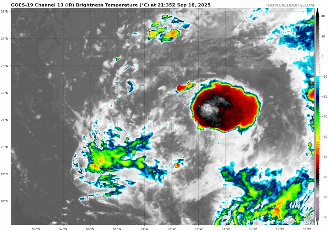
Re: NATL: GABRIELLE - Tropical Storm - Discussion
Gabrielle seems to have improved substantially over the course of the day, judging by recent LWIR satellite imagery. Curious to see if she'll continue to pick up the pace or if the improvement is only temporary.
0 likes
-
cycloneye
- Admin
- Posts: 149696
- Age: 69
- Joined: Thu Oct 10, 2002 10:54 am
- Location: San Juan, Puerto Rico
Re: NATL: GABRIELLE - Tropical Storm - Discussion
One step away from hurricane according to dvorak sab.
A. 07L (GABRIELLE)
B. 20/0000Z
C. 22.9N
D. 56.9W
E. FIVE/GOES-E
F. T3.5/3.5
G. IR/EIR/PRXY
H. REMARKS...CENTER EMBEDDED 1/3 DEG INTO A LARGE COLD OVERCAST RESULTS
IN A DT OF 3.5. THE MET AND PT ARE UNDEFINED DUE TO THE SYSTEM BEING
SUBTROPICAL 24 HOURS AGO. THE FT IS BASED ON THE DT.
I. ADDL POSITIONS
NIL
...LINER
B. 20/0000Z
C. 22.9N
D. 56.9W
E. FIVE/GOES-E
F. T3.5/3.5
G. IR/EIR/PRXY
H. REMARKS...CENTER EMBEDDED 1/3 DEG INTO A LARGE COLD OVERCAST RESULTS
IN A DT OF 3.5. THE MET AND PT ARE UNDEFINED DUE TO THE SYSTEM BEING
SUBTROPICAL 24 HOURS AGO. THE FT IS BASED ON THE DT.
I. ADDL POSITIONS
NIL
...LINER
0 likes
Visit the Caribbean-Central America Weather Thread where you can find at first post web cams,radars
and observations from Caribbean basin members Click Here
and observations from Caribbean basin members Click Here

Re: NATL: GABRIELLE - Tropical Storm - Discussion
ElectricStorm wrote:Looks a lot better than it did earlier today, now we'll see if that can continue. Noticed the NHC went a little higher on the peak this cycle at 90kts. Would be nice to see an open Atlantic major as long as it misses Bermuda.
Yep, big improvement actually. Checking out the Dvorak BD curve, I'd venture to guess we'll see a partial eye clear out tomorrow and possibly tettering on Hurricane upgrade by dinner-time today IF it can maintain its vigorous convection. Only other thought atm is that it appears to be tracking more westward but it's tough to be sure under that dense CDO.
1 likes
Andy D
(For official information, please refer to the NHC and NWS products.)
(For official information, please refer to the NHC and NWS products.)
Who is online
Users browsing this forum: No registered users and 65 guests