WPAC: RAGASA - Typhoon

Detailed discussion and tracking of all WestPac basin storms with special input from staff of our partner site, WesternPacificWeather

Moderators: S2k Moderators, WesternPacificWeatherMods

Forum rules

The posts in this forum are NOT official forecast and should not be used as such. They are just the opinion of the poster and may or may not be backed by sound meteorological data. They are NOT endorsed by any professional institution or STORM2K.

Help Support Storm2K
Message
Author
User avatar
mrbagyo
Category 5
Category 5
Posts: 3785
Age: 33
Joined: Thu Apr 12, 2012 9:18 am
Location: 14.13N 120.98E
Contact:

Re: WPAC: 90W - Tropical Depression

#21 Postby mrbagyo » Thu Sep 18, 2025 7:42 am

cycloneye wrote:
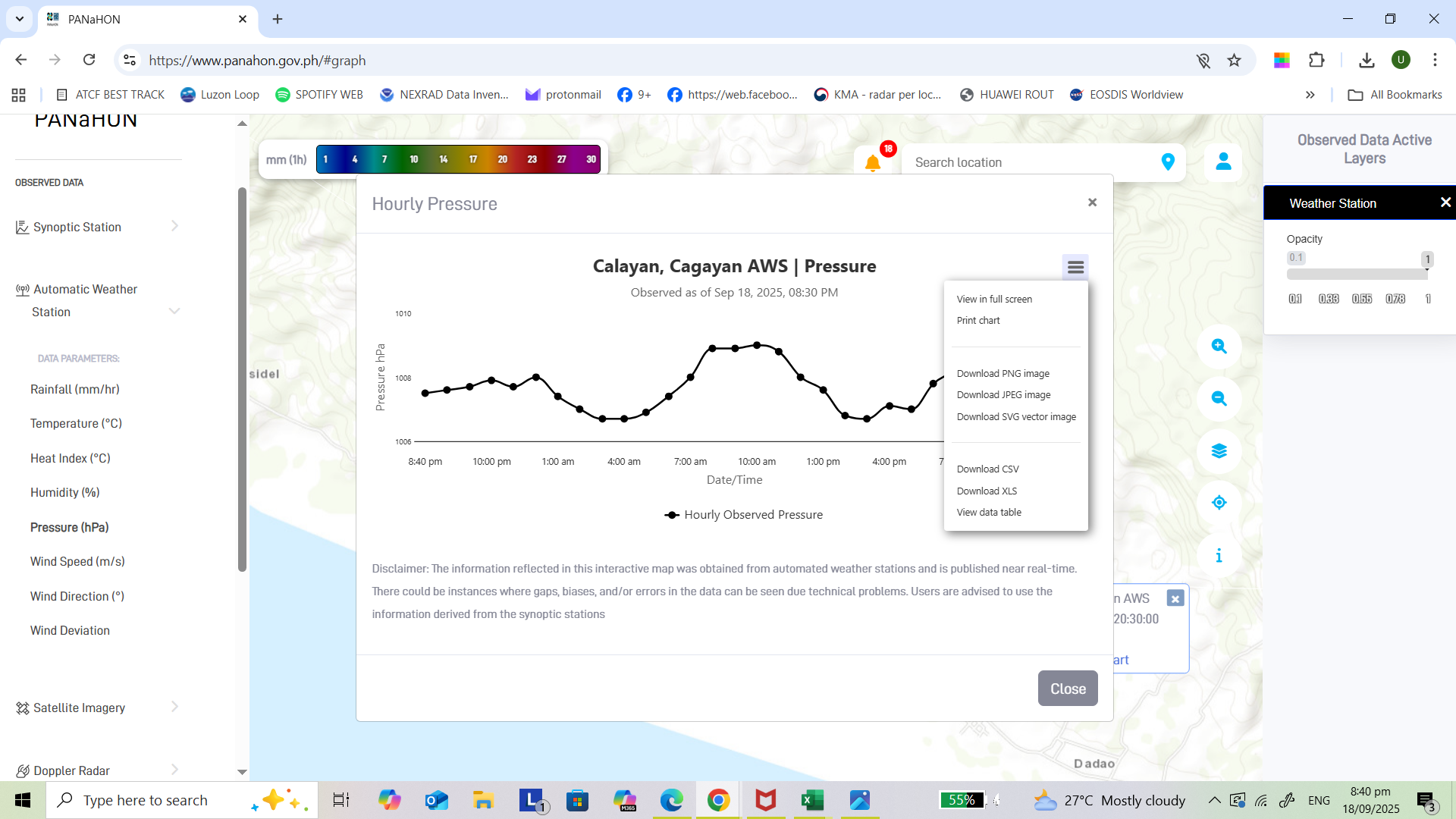
mrbagyo wrote:I hope this AWS stays up if 90W makes a trip over the Calayan Island.

AWS
https://s14.gifyu.com/images/bTBSO.png


vs


SYNOPTIC
https://s14.gifyu.com/images/bTBSB.png


Do you have the link?


Panahon.gov link

Image
1 likes   
The posts in this forum are NOT official forecast and should not be used as such. They are just the opinion of the poster and may or may not be backed by sound meteorological data. They are NOT endorsed by any professional institution or storm2k.org. For official information, please refer to RSMC, NHC and NWS products.

User avatar
Hayabusa
Category 5
Category 5
Posts: 4580
Joined: Sun Sep 16, 2018 1:05 pm

Re: WPAC: 24W - Tropical Depression

#22 Postby Hayabusa » Thu Sep 18, 2025 8:09 am

24W TWENTYFOUR 250918 1200 15.9N 133.0E WPAC 30 1005
0 likes   
ヤンデレ女が寝取られるているのを見たい!!!
ECMWF ensemble NWPAC plots: https://ecmwfensnwpac.imgbb.com/
Multimodel NWPAC plots: https://multimodelnwpac.imgbb.com/
GFS Ensemble NWPAC plots (16 & 35 day forecast): https://gefsnwpac.imgbb.com/
Plots updated automatically

User avatar
Hayabusa
Category 5
Category 5
Posts: 4580
Joined: Sun Sep 16, 2018 1:05 pm

Re: WPAC: RAGASA - Tropical Storm

#23 Postby Hayabusa » Thu Sep 18, 2025 8:11 am

Jma named it as Ragasa
0 likes   
ヤンデレ女が寝取られるているのを見たい!!!
ECMWF ensemble NWPAC plots: https://ecmwfensnwpac.imgbb.com/
Multimodel NWPAC plots: https://multimodelnwpac.imgbb.com/
GFS Ensemble NWPAC plots (16 & 35 day forecast): https://gefsnwpac.imgbb.com/
Plots updated automatically

User avatar
mrbagyo
Category 5
Category 5
Posts: 3785
Age: 33
Joined: Thu Apr 12, 2012 9:18 am
Location: 14.13N 120.98E
Contact:

Re: WPAC: RAGASA - Tropical Storm

#24 Postby mrbagyo » Thu Sep 18, 2025 8:22 am

Hayabusa wrote:Jma named it as Ragasa


Derived from the root word ‘ragasa,’ the Tagalog verb ‘rumaragasa’ means ‘raging’ or ‘surging,’ and is often used to describe the intense, fast movement of flowing water.
2 likes   
The posts in this forum are NOT official forecast and should not be used as such. They are just the opinion of the poster and may or may not be backed by sound meteorological data. They are NOT endorsed by any professional institution or storm2k.org. For official information, please refer to RSMC, NHC and NWS products.

User avatar
mrbagyo
Category 5
Category 5
Posts: 3785
Age: 33
Joined: Thu Apr 12, 2012 9:18 am
Location: 14.13N 120.98E
Contact:

Re: WPAC: RAGASA - Tropical Storm

#25 Postby mrbagyo » Thu Sep 18, 2025 9:47 am

EURO simulated visible loop

Image
0 likes   
The posts in this forum are NOT official forecast and should not be used as such. They are just the opinion of the poster and may or may not be backed by sound meteorological data. They are NOT endorsed by any professional institution or storm2k.org. For official information, please refer to RSMC, NHC and NWS products.

User avatar
cycloneye
Admin
Admin
Posts: 146926
Age: 69
Joined: Thu Oct 10, 2002 10:54 am
Location: San Juan, Puerto Rico

Re: WPAC: RAGASA - Tropical Storm

#26 Postby cycloneye » Thu Sep 18, 2025 10:04 am

IMO, that 115kt peak is a bit conservative based on the guidance.

Image
0 likes   
Visit the Caribbean-Central America Weather Thread where you can find at first post web cams,radars
and observations from Caribbean basin members Click Here
User avatar
ElectricStorm
Category 5
Category 5
Posts: 5089
Age: 24
Joined: Tue Aug 13, 2019 11:23 pm
Location: Skiatook, OK / Norman, OK

Re: WPAC: RAGASA - Tropical Storm

#27 Postby ElectricStorm » Thu Sep 18, 2025 10:20 am

Well we had to wait all the way to mid September but we finally have a legit candidate for the first super typhoon of the year, and just the second storm to even hit Cat 3. We'll see if it can live up to the model hype unlike a couple previous systems.
3 likes   
B.S Meteorology, University of Oklahoma '25

Please refer to the NHC, NWS, or SPC for official information.

User avatar
cycloneye
Admin
Admin
Posts: 146926
Age: 69
Joined: Thu Oct 10, 2002 10:54 am
Location: San Juan, Puerto Rico

Re: WPAC: RAGASA - Tropical Storm

#28 Postby cycloneye » Thu Sep 18, 2025 10:47 am

FORECAST DISCUSSION: 24W IS FORECAST TO TRACK GENERALLY
WEST-NORTHWESTWARD OVER THE NEXT 72 HOURS. TRACK SPEEDS ARE
EXPECTED TO BE RELATIVELY SLOW DUE TO THE WEAK STEERING PATTERN AS
THE SUBTROPICAL RIDGE TO THE NORTH GRADUALLY BUILDS. AFTER TAU 72,
THE RIDGE CENTERED SOUTH OF KYUSHU WILL HAVE MORE INFLUENCE ON THE
MOTION OF THE VORTEX, CAUSING TRACK SPEEDS TO PICK UP AND THE TRACK
TO TURN MORE WESTWARD. A WESTWARD TRACK THROUGH THE LUZON STRAIT IS
EXPECTED TO PERSIST FROM TAU 96 THROUGH THE REMAINDER OF THE
FORECAST PERIOD. REGARDING INTENSITY, 24W IS FORECAST TO STEADILY
INTENSIFY THROUGH TAU 36 TO AROUND 60 DUE TO THE FAVORABLE
ENVIRONMENT. AFTER TAU 36, POLEWARD OUTFLOW IS EXPECTED TO MARKEDLY
INCREASE, ALLOWING FOR RAPID INTENSIFICATION THROUGH TAU 72 TO
AROUND 105 KTS. SEA SURFACE TEMPERATURES WILL REMAIN VERY WARM
THROUGH THE ENTIRE FORECAST, ALLOWING FOR PRIME CONDITIONS FOR
INTENSIFICATION. AS THE SYSTEM TRACKS THROUGH THE LUZON STRAIT, 24W
IS FORECAST TO REACH A PEAK INTENSITY OF NEAR 115 KTS. NEAR THE END
OF THE FORECAST, NORTHEASTERLY SHEAR IS EXPECTED TO SLIGHTLY
INCREASE TO AROUND 15-20 KTS, CAUSING THE INTENSIFICATION TREND TO
HALT.

MODEL DISCUSSION: NUMERICAL MODEL TRACK GUIDANCE IS IN GOOD
AGREEMENT THROUGHOUT THE FORECAST WITH A 128 NM CROSS-TRACK SPREAD
AT TAU 72 AND A 182 NM CROSS-TRACK SPREAD AT TAU 120. THERE ARE
ALSO NO SIGNIFICANT OUTLIERS, ALLOWING FOR THE JTWC TRACK FORECAST
TO BE PLACED WITH OVERALL MEDIUM CONFIDENCE. INTENSITY GUIDANCE, ON
THE OTHER HAND, HAS QUITE A BIT MORE UNCERTAINTY. THOUGH ALL MODELS
DEPICT INTENSIFICATION THROUGH TAU 96, THE RATE OF INTENSIFICATION
VARIES. MANY RAPID INTENSIFICATION AIDS ARE TRIGGERING, SUGGESTING
AS HIGH AS 100 KTS IN 48 HOURS. HAFS-A HAS A PEAK INTENSITY OF 140
KTS AT TAU 84 AND IS THE MOST AGGRESSIVE MODEL IN TERMS OF THE PEAK.
THE JTWC INTENSITY FORECAST IS PLACED IN LINE WITH THE MULTI-MODEL
CONSENSUS THROUGH TAU 48 AND THEN ABOUT 10-15 KTS HIGHER AFTERWARD
WITH OVERALL LOW CONFIDENCE.
0 likes   
Visit the Caribbean-Central America Weather Thread where you can find at first post web cams,radars
and observations from Caribbean basin members Click Here

User avatar
cycloneye
Admin
Admin
Posts: 146926
Age: 69
Joined: Thu Oct 10, 2002 10:54 am
Location: San Juan, Puerto Rico

Re: WPAC: RAGASA - Tropical Storm

#29 Postby cycloneye » Thu Sep 18, 2025 12:41 pm

I begin to fear for those people who live in those small islands between Luzón and Taiwan, not only about the very strong winds but the big storm surge. :eek:

12z HAFS-A:

Image
0 likes   
Visit the Caribbean-Central America Weather Thread where you can find at first post web cams,radars
and observations from Caribbean basin members Click Here

User avatar
Hayabusa
Category 5
Category 5
Posts: 4580
Joined: Sun Sep 16, 2018 1:05 pm

Re: WPAC: RAGASA - Tropical Storm

#30 Postby Hayabusa » Thu Sep 18, 2025 1:29 pm

Euro (and its AI) 12z striking Hong Kong, could be a new record holder for Hong Kong.
0 likes   
ヤンデレ女が寝取られるているのを見たい!!!
ECMWF ensemble NWPAC plots: https://ecmwfensnwpac.imgbb.com/
Multimodel NWPAC plots: https://multimodelnwpac.imgbb.com/
GFS Ensemble NWPAC plots (16 & 35 day forecast): https://gefsnwpac.imgbb.com/
Plots updated automatically

User avatar
cycloneye
Admin
Admin
Posts: 146926
Age: 69
Joined: Thu Oct 10, 2002 10:54 am
Location: San Juan, Puerto Rico

Re: WPAC: RAGASA - Tropical Storm

#31 Postby cycloneye » Thu Sep 18, 2025 1:48 pm

JTWC up to TS Ragasa.

24W RAGASA 250918 1800 16.2N 132.3E WPAC 35 1004
0 likes   
Visit the Caribbean-Central America Weather Thread where you can find at first post web cams,radars
and observations from Caribbean basin members Click Here

User avatar
cycloneye
Admin
Admin
Posts: 146926
Age: 69
Joined: Thu Oct 10, 2002 10:54 am
Location: San Juan, Puerto Rico

Re: WPAC: RAGASA - Tropical Storm

#32 Postby cycloneye » Thu Sep 18, 2025 3:20 pm

21z.

Image

FORECAST DISCUSSION: TS 24W IS FORECAST TO SLOWLY TRACK
WEST-NORTHWESTWARD OVER THE NEXT 24 HOURS, WHILE POSITIONED IN A
WEAK STEERING ENVIRONMENT. AROUND TAU 24, THE STR WILL BUILD TO THE
NORTHEAST OF THE SYSTEM RESULTING IN SLIGHT ACCELERATION AS WELL AS
A MORE NORTHWESTWARD TRACK FOR A PERIOD OF ANOTHER 24 HOURS.
AFTERWARDS, THE RIDGE WILL CONTINUE TO BUILD AND EXTEND EASTWARD,
RESULTING IN A RETURN TO A GENERALLY WEST-NORTHWESTWARD TRACK,
WHICH IS EXPECTED TO LAST THROUGHOUT THE CURRENT FORECAST PERIOD.
IN TERMS OF INTENSITY, TS 24W IS EXPECTED TO UTILIZE THE
OVERWHELMINGLY FAVORABLE ENVIRONMENT AND INTENSIFY CONTINUOUSLY
THROUGH AROUND TAU 96, WITH POTENTIAL PERIODS OF RAPID
INTENSIFICATION (RI). PEAK INTENSITY IS EXPECTED TO REACH 115-125
KTS BETWEEN TAUS 72 AND 96. THE ONLY HINDRANCE TO DEVELOPMENT IS
PRESENCE OF DRY AIR TO THE NORTH, BUT CURRENTLY AVAILABLE MODEL
GUIDANCE INDICATES THAT THE SYSTEM WILL BE ABLE TO OVERCOME THOSE
IMPACTS WITHIN THE NEXT 36 TO 42 HOURS. BETWEEN TAU 96 AND 120, TS
RAGASA IS FORECAST TO BEGIN WEAKENING, AS ITS WIND FIELD STARTS
INTERACTING WITH THE TERRAIN OF NORTHERN LUZON, SOUTHERN TAIWAN AND
EVENTUALLY AS THE SYSTEM APPROACHES THE SOUTHEASTERN COAST OF
CHINA.

MODEL DISCUSSION: NUMERICAL MODEL TRACK GUIDANCE IS IN FAIR
AGREEMENT THROUGHOUT THE FORECAST, WITH ALL AVAILABLE GUIDANCE
PREDICTING A GENERALLY NORTHWESTWARD TRACK THROUGHOUT THE FORECAST
PERIOD. JTWC OFFICIAL TRACK IS LAID CLOSE TO THE MULTI-MODEL
CONSENSUS WITH MEDIUM CONFIDENCE, WHICH REFLECTS THE UNCERTAINTY
ASSOCIATED WITH THE INITIALLY WEAK STEERING ENVIRONMENT. THIS IS
EVIDENT THROUGH A 40 NM CROSS-TRACK SPREAD AT TAU 12, OPENING TO
140 NM BY TAU 48 AND EVENTUALLY NEARLY 300 NM AS THE SYSTEM
APPROACHES LANDFALL. ALL CURRENTLY AVAILABLE GUIDANCE HOWEVER
INDICATES TRACK WITHIN THE LUZON STRAIT, WITH MAJORITY OF THE
MODELS POINTING TOWARDS CENTERED PLACEMENT. JTWC INTENSITY FORECAST
IS ASSESSED ON THE HIGHER END OF THE MULTI-MODEL CONSENSUS WITH
MEDIUM CONFIDENCE THROUGH TAU 72. ALL MODELS SHOW GOOD AGREEMENT
WITH MULTIPLE RI AIDS TRIGGERED (RICN, RIPA, FRIA, RIDE). AFTER TAU
72 THE GUIDANCE IS MORE SPREAD, WITH MOST CONSERVATIVE
NAVGEM-DRIVEN COAMPS-TC (SHOWING PEAK OF 90-95 KTS) AND MOST
AGGRESSIVE HAFS-A (INDICATING 130-135 KTS MAXIMUM WINDS AROUND TAU
84. OVERALL INTENSITY SPREAD AT PEAK IS CURRENTLY 55 KTS,
REFLECTIVE THE LOW FORECAST CONFIDENCE BEYOND TAU 72.
1 likes   
Visit the Caribbean-Central America Weather Thread where you can find at first post web cams,radars
and observations from Caribbean basin members Click Here

User avatar
cycloneye
Admin
Admin
Posts: 146926
Age: 69
Joined: Thu Oct 10, 2002 10:54 am
Location: San Juan, Puerto Rico

Re: WPAC: RAGASA - Tropical Storm

#33 Postby cycloneye » Thu Sep 18, 2025 6:26 pm

Image
1 likes   
Visit the Caribbean-Central America Weather Thread where you can find at first post web cams,radars
and observations from Caribbean basin members Click Here

User avatar
cycloneye
Admin
Admin
Posts: 146926
Age: 69
Joined: Thu Oct 10, 2002 10:54 am
Location: San Juan, Puerto Rico

Re: WPAC: RAGASA - Tropical Storm

#34 Postby cycloneye » Thu Sep 18, 2025 8:15 pm

A. 24W (RAGASA)

B. 18/2330Z

C. 16.4N

D. 131.1E

E. FIVE/HIMAWARI-9

F. T2.0/2.0

G. IR/EIR/SWIR/PRXY

H. REMARKS...SYSTEM CHARACTERIZED BY CIRCULARLY DEFINED CLOUD LINES WITH
A LLCC <1.25 DEG FROM A LARGE COLD OVERCAST RESULTS IN A DT OF 2.0. THE
MET EQUALS 1.5 AND THE PT EQUALS 2.0. THE FT IS BASED ON THE PT DUE TO
PULSING/IRREGULAR CONVECTION AND UNCERTAINTY IN THE EXACT LLCC LOCATION.

I. ADDL POSITIONS

NIL


...LINER
0 likes   
Visit the Caribbean-Central America Weather Thread where you can find at first post web cams,radars
and observations from Caribbean basin members Click Here

User avatar
cycloneye
Admin
Admin
Posts: 146926
Age: 69
Joined: Thu Oct 10, 2002 10:54 am
Location: San Juan, Puerto Rico

Re: WPAC: RAGASA - Tropical Storm

#35 Postby cycloneye » Thu Sep 18, 2025 9:31 pm

New peak intensity at 120kt. Hong Kong may be in crosshairs.

Image
0 likes   
Visit the Caribbean-Central America Weather Thread where you can find at first post web cams,radars
and observations from Caribbean basin members Click Here

User avatar
Hayabusa
Category 5
Category 5
Posts: 4580
Joined: Sun Sep 16, 2018 1:05 pm

Re: WPAC: RAGASA - Tropical Storm

#36 Postby Hayabusa » Thu Sep 18, 2025 11:43 pm

18Z eps has 180 kts max wind peak ensemble :double:
Image
0 likes   
ヤンデレ女が寝取られるているのを見たい!!!
ECMWF ensemble NWPAC plots: https://ecmwfensnwpac.imgbb.com/
Multimodel NWPAC plots: https://multimodelnwpac.imgbb.com/
GFS Ensemble NWPAC plots (16 & 35 day forecast): https://gefsnwpac.imgbb.com/
Plots updated automatically

User avatar
cycloneye
Admin
Admin
Posts: 146926
Age: 69
Joined: Thu Oct 10, 2002 10:54 am
Location: San Juan, Puerto Rico

Re: WPAC: RAGASA - Tropical Storm

#37 Postby cycloneye » Fri Sep 19, 2025 3:46 am

Image
0 likes   
Visit the Caribbean-Central America Weather Thread where you can find at first post web cams,radars
and observations from Caribbean basin members Click Here

User avatar
kevin
Category 5
Category 5
Posts: 2686
Age: 26
Joined: Wed Aug 28, 2019 4:35 am

Re: WPAC: RAGASA - Tropical Storm

#38 Postby kevin » Fri Sep 19, 2025 3:50 am

00z hurricane models peak intensity:

HWRF = 922 mb / 134 kt
HAFS-A = 904 mb / 156 kt
0 likes   

User avatar
cycloneye
Admin
Admin
Posts: 146926
Age: 69
Joined: Thu Oct 10, 2002 10:54 am
Location: San Juan, Puerto Rico

Re: WPAC: RAGASA - Tropical Storm

#39 Postby cycloneye » Fri Sep 19, 2025 7:46 am

A. 24W (RAGASA)

B. 19/1130Z

C. 16.2N

D. 130.0E

E. THREE/HIMAWARI-9

F. T3.0/3.0

G. IR/EIR/SWIR/PRXY

H. REMARKS...LLCC LOCATED >1/3 DEGREE INTO DG RESULTS IN A DT OF 3.5
USING THE SHEAR PATTERN. THE MET IS 3.0 BASED ON A RAPIDLY DEVELOPING 24
HOUR TREND. THE PT IS 3.0. THE FT IS BASED ON THE MET DUE TO UNCERTAINTY
IN EXACT CENTER LOCATION.

I. ADDL POSITIONS

NIL


...MONAGHAN
0 likes   
Visit the Caribbean-Central America Weather Thread where you can find at first post web cams,radars
and observations from Caribbean basin members Click Here

User avatar
cycloneye
Admin
Admin
Posts: 146926
Age: 69
Joined: Thu Oct 10, 2002 10:54 am
Location: San Juan, Puerto Rico

Re: WPAC: RAGASA - Tropical Storm

#40 Postby cycloneye » Fri Sep 19, 2025 8:24 am

24W RAGASA 250919 1200 16.3N 130.1E WPAC 45 996


Image
0 likes   
Visit the Caribbean-Central America Weather Thread where you can find at first post web cams,radars
and observations from Caribbean basin members Click Here


Return to “Active Storms - WestPAC/Asia”

Who is online

Users browsing this forum: Ulf and 32 guests