
NATL: HUMBERTO - Remnants - Discussion
Moderator: S2k Moderators
-
cycloneye

- Admin

- Posts: 149664
- Age: 69
- Joined: Thu Oct 10, 2002 10:54 am
- Location: San Juan, Puerto Rico
Re: NATL: INVEST 93L - Discussion (80/90)
ASCAT is needed to see if it is already a TD or not.
1 likes
Visit the Caribbean-Central America Weather Thread where you can find at first post web cams,radars
and observations from Caribbean basin members Click Here
and observations from Caribbean basin members Click Here

Re: NATL: INVEST 93L - Discussion (80/90)
Much further along that 94L, it seems. If this keeps up then it’ll probably become the dominant system like in today’s 6z GFS, which’ll be great for everyone on the East Coast.
0 likes
Irene '11 Sandy '12 Hermine '16 5/15/2018 Derecho Fay '20 Isaias '20 Elsa '21 Henri '21 Ida '21
I am only a meteorology enthusiast who knows a decent amount about tropical cyclones. Look to the professional mets, the NHC, or your local weather office for the best information.
I am only a meteorology enthusiast who knows a decent amount about tropical cyclones. Look to the professional mets, the NHC, or your local weather office for the best information.
-
cycloneye
- Admin
- Posts: 149664
- Age: 69
- Joined: Thu Oct 10, 2002 10:54 am
- Location: San Juan, Puerto Rico
Re: NATL: INVEST 93L - Discussion (90/90)
Central and Western Tropical Atlantic (AL93):
Shower and thunderstorm activity associated with an elongated area
of low pressure located several hundred miles east of the Leeward
Islands continues to show signs of organization. Environmental
conditions are forecast to be favorable for further development, and
a tropical depression is likely to form later today or Thursday
while the system moves west-northwestward to northwestward into the
western tropical Atlantic, well north of the Leeward Islands.
Additional information on this system, including gale warnings, can
be found in High Seas Forecasts issued by the National Weather
Service.
* Formation chance through 48 hours...high...90 percent.
* Formation chance through 7 days...high...90 percent.
0 likes
Visit the Caribbean-Central America Weather Thread where you can find at first post web cams,radars
and observations from Caribbean basin members Click Here
and observations from Caribbean basin members Click Here
-
cycloneye
- Admin
- Posts: 149664
- Age: 69
- Joined: Thu Oct 10, 2002 10:54 am
- Location: San Juan, Puerto Rico
Re: NATL: INVEST 93L - Discussion (90/90)
AL, 93, 2025092412, , BEST, 0, 191N, 537W, 30, 1010, DB
0 likes
Visit the Caribbean-Central America Weather Thread where you can find at first post web cams,radars
and observations from Caribbean basin members Click Here
and observations from Caribbean basin members Click Here

Re: NATL: INVEST 93L - Discussion (90/90)
Still disheveled, but will easily meet the criteria for a TC soon.
0 likes
TC naming lists: retirements and intensity
Most aggressive Advisory #1's in North Atlantic (cr. kevin for starting the list)
Most aggressive Advisory #1's in North Atlantic (cr. kevin for starting the list)
Re: NATL: INVEST 93L - Discussion (90/90)
hy2b scat, no development for either wave today. no closed LLC on here anyway. It's not out of the question neither wave winds up developing. But I'd suspect maybe late Thursday or Friday for this one and late sat/sunday for 94.

Last edited by BobHarlem on Wed Sep 24, 2025 9:55 am, edited 1 time in total.
0 likes
Re: NATL: INVEST 93L - Discussion (90/90)
1 likes
Re: NATL: INVEST 93L - Discussion (90/90)
zzzh wrote::uarrow: That's not the ASCAT. That's the HY-2B scatterometer and is not very accurate in general.
True, but no closed llc is still the callout.
0 likes
Re: NATL: INVEST 93L - Discussion (90/90)
BobHarlem wrote:hy2b scat, no development for either wave today. no closed LLC on here anyway. It's not out of the question neither wave winds up developing. But I'd suspect maybe late Thursday or Friday for this one and late sat/sunday for 94.
https://i.imgur.com/5911478.png
Here's a swirl around 19.5N 54.3W, which would contradict the "no closed LLC".
2 likes
TC naming lists: retirements and intensity
Most aggressive Advisory #1's in North Atlantic (cr. kevin for starting the list)
Most aggressive Advisory #1's in North Atlantic (cr. kevin for starting the list)

Re: NATL: INVEST 93L - Discussion (90/90)
While unfortunately not complete enough to say anything about a closed circulation, an ASCAT pass from about 16 hours ago already had one 35 kt barb.

1 likes


Re: NATL: INVEST 93L - Discussion (90/90)
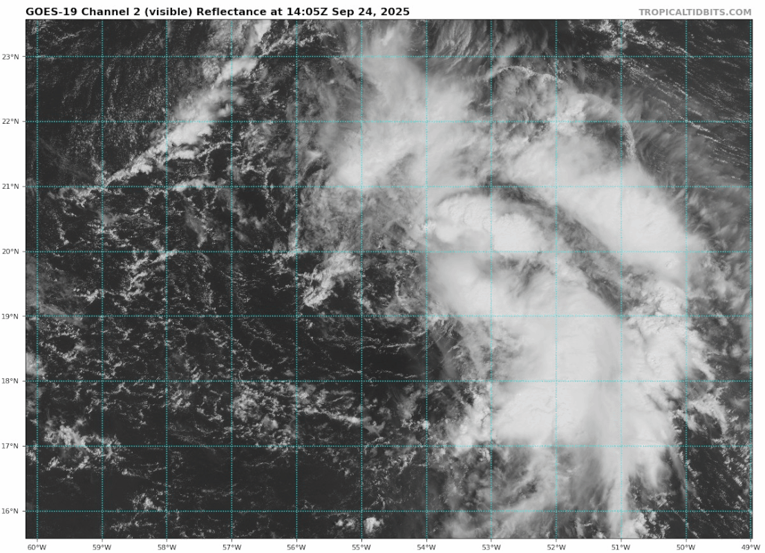
Teban54 wrote:BobHarlem wrote:hy2b scat, no development for either wave today. no closed LLC on here anyway. It's not out of the question neither wave winds up developing. But I'd suspect maybe late Thursday or Friday for this one and late sat/sunday for 94.
https://i.imgur.com/5911478.png
Here's a swirl around 19.5N 54.3W, which would contradict the "no closed LLC".
https://i.postimg.cc/QC6QZvYw/goes19-vis-93-L-202509241405.gif
Can't deny what the eyes see! 12 hr's from now we'll could well have building convection over and near that center. Or, that tiny circulation could have spit out while running ahead of the convection due to the UL shear. That would be my primary contention with an upgrade at this time.
0 likes
Andy D
(For official information, please refer to the NHC and NWS products.)
(For official information, please refer to the NHC and NWS products.)
Re: NATL: INVEST 93L - Discussion (90/90)
Very interested what recon will find. Some of the models indicate 93L should already be around TS intensity right now:
12z GFS = 1012 mb, 35 kt
12z HWRF = 1013 mb, 36 kt
12z HMON = 1010 mb, 34 kt
12z HAFS-A = 1009 mb, 38 kt
12z HAFS-B = 1009 mb, 36 kt
12z GFS = 1012 mb, 35 kt
12z HWRF = 1013 mb, 36 kt
12z HMON = 1010 mb, 34 kt
12z HAFS-A = 1009 mb, 38 kt
12z HAFS-B = 1009 mb, 36 kt
0 likes
Re: NATL: INVEST 93L - Discussion (90/90)
kevin wrote:Very interested what recon will find. Some of the models indicate 93L should already be around TS intensity right now:
12z GFS = 1012 mb, 35 kt
12z HWRF = 1013 mb, 36 kt
12z HMON = 1010 mb, 34 kt
12z HAFS-A = 1009 mb, 38 kt
12z HAFS-B = 1009 mb, 36 kt
When is recon scheduled for 93L? The initial mission is for 94L (Gulfstream for UL sampling I think).
0 likes
Andy D
(For official information, please refer to the NHC and NWS products.)
(For official information, please refer to the NHC and NWS products.)
-
desertrat75
- Tropical Wave

- Posts: 4
- Joined: Tue Aug 26, 2008 3:47 pm
Re: NATL: INVEST 93L - Discussion (90/90)
Hey. Sorry for the stupid question, but which one of these is 93 and which one is 94? It's never on the maps until they're named.
0 likes
-
tolakram
- Admin
- Posts: 20186
- Age: 62
- Joined: Sun Aug 27, 2006 8:23 pm
- Location: Florence, KY (name is Mark)
Re: NATL: INVEST 93L - Discussion (90/90)
desertrat75 wrote:Hey. Sorry for the stupid question, but which one of these is 93 and which one is 94? It's never on the maps until they're named.
At the NHC site hover over the map. I'm over the right hand red area.

0 likes
M a r k
- - - - -
Join us in chat: Storm2K Chatroom Invite. Android and IOS apps also available.
The posts in this forum are NOT official forecasts and should not be used as such. Posts are NOT endorsed by any professional institution or STORM2K.org. For official information and forecasts, please refer to NHC and NWS products.
Re: NATL: INVEST 93L - Discussion (90/90)
Teban54 wrote:BobHarlem wrote:hy2b scat, no development for either wave today. no closed LLC on here anyway. It's not out of the question neither wave winds up developing. But I'd suspect maybe late Thursday or Friday for this one and late sat/sunday for 94.
https://i.imgur.com/5911478.png
Here's a swirl around 19.5N 54.3W, which would contradict the "no closed LLC".
https://i.postimg.cc/QC6QZvYw/goes19-vis-93-L-202509241405.gif
Latest satellite showing the well defined center becoming co-located with the convection atm. I'd guess NHC will pull the T.D. trigger between this evening and tomorrow a.m.
0 likes
Andy D
(For official information, please refer to the NHC and NWS products.)
(For official information, please refer to the NHC and NWS products.)
-
TomballEd
- Category 5

- Posts: 1313
- Age: 62
- Joined: Wed Aug 16, 2023 4:52 pm
- Location: Spring/Klein area, not Tomball
Re: NATL: INVEST 93L - Discussion (90/90)
It has a *mostly* naked LLC. Its sheared, but it has storms. I'd upgrade at 4 pm if I were King of NHC.
0 likes
-
tolakram
- Admin
- Posts: 20186
- Age: 62
- Joined: Sun Aug 27, 2006 8:23 pm
- Location: Florence, KY (name is Mark)
Re: NATL: INVEST 93L - Discussion (90/90)
Here we go, and some doubt but I still think this is a TD.

5 likes
M a r k
- - - - -
Join us in chat: Storm2K Chatroom Invite. Android and IOS apps also available.
The posts in this forum are NOT official forecasts and should not be used as such. Posts are NOT endorsed by any professional institution or STORM2K.org. For official information and forecasts, please refer to NHC and NWS products.
- - - - -
Join us in chat: Storm2K Chatroom Invite. Android and IOS apps also available.
The posts in this forum are NOT official forecasts and should not be used as such. Posts are NOT endorsed by any professional institution or STORM2K.org. For official information and forecasts, please refer to NHC and NWS products.
-
cycloneye
- Admin
- Posts: 149664
- Age: 69
- Joined: Thu Oct 10, 2002 10:54 am
- Location: San Juan, Puerto Rico
Re: NATL: INVEST 93L - Discussion (90/90)
TD or TS this afternoon or evening.
Central and Western Tropical Atlantic (AL93):
A low pressure system located several hundred miles east of the
Leeward Islands, has become better defined with showers and
thunderstorms becoming better organized this afternoon. If these
trends continue, advisories could be initiated on a tropical
depression or storm later today or tonight. The system is expected
to move generally west-northwestward to northwestward into the
western tropical Atlantic, well north of the Leeward Islands.
Additional information on this system, including gale warnings, can
be found in High Seas Forecasts issued by the National Weather
Service.
* Formation chance through 48 hours...high...90 percent.
* Formation chance through 7 days...high...90 percent.
2 likes
Visit the Caribbean-Central America Weather Thread where you can find at first post web cams,radars
and observations from Caribbean basin members Click Here
and observations from Caribbean basin members Click Here
-
Sciencerocks
- Category 5
- Posts: 10189
- Age: 40
- Joined: Thu Jul 06, 2017 1:51 am

Who is online
Users browsing this forum: No registered users and 77 guests