
NATL: HUMBERTO - Remnants - Discussion
Moderator: S2k Moderators
-
cycloneye

- Admin

- Posts: 149691
- Age: 69
- Joined: Thu Oct 10, 2002 10:54 am
- Location: San Juan, Puerto Rico
Re: NATL: HUMBERTO - Tropical Storm - Discussion
1 likes
Visit the Caribbean-Central America Weather Thread where you can find at first post web cams,radars
and observations from Caribbean basin members Click Here
and observations from Caribbean basin members Click Here
-
ScottNAtlanta

- Category 5

- Posts: 2535
- Joined: Sat May 25, 2013 3:11 pm
- Location: Atlanta, GA
Re: NATL: HUMBERTO - Tropical Storm - Discussion
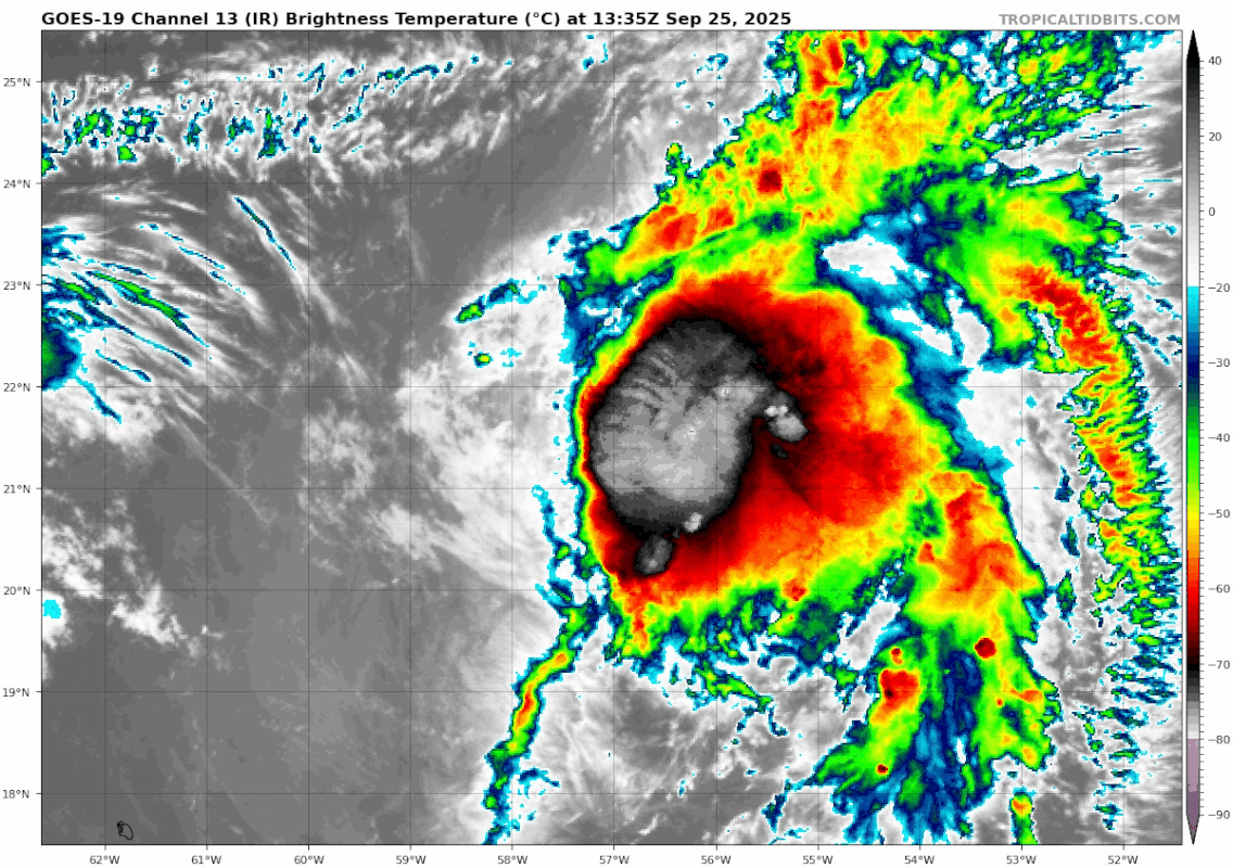
There is a huge blow up over the center this morning. This is ready to go

2 likes
The posts in this forum are NOT official forecast and should not be used as such. They are just the opinion of the poster and may or may not be backed by sound meteorological data. They are NOT endorsed by any professional institution or storm2k.org. For official information, please refer to the NHC and NWS products.

Re: NATL: HUMBERTO - Tropical Storm - Discussion
Looks like the 20-40 kts of westerly shear has shifted north of the storm this morning. Should actually now aid in ventilation.
2 likes
-
MEANINGLESS_NUMBERS
- Category 2

- Posts: 503
- Joined: Mon Nov 02, 2020 1:43 pm
Re: NATL: HUMBERTO - Tropical Storm - Discussion
Still don't see any outflow on the west side - looks like shear still limiting it a little. Won't be enough to stop some strengthening though.
1 likes
Emily '87, Felix '95, Gert '99, Fabian '03, Humberto '19, Paulette '20, Teddy '20, Fiona '22, Lee '23, Ernesto '24, Humberto/Imelda '25

Re: NATL: HUMBERTO - Tropical Storm - Discussion
Does the last frame count as a shrimp? 

2 likes
TC naming lists: retirements and intensity
Most aggressive Advisory #1's in North Atlantic (cr. kevin for starting the list)
Most aggressive Advisory #1's in North Atlantic (cr. kevin for starting the list)
-
tolakram
- Admin
- Posts: 20186
- Age: 62
- Joined: Sun Aug 27, 2006 8:23 pm
- Location: Florence, KY (name is Mark)
Re: NATL: HUMBERTO - Tropical Storm - Discussion
saved loop

5 likes
M a r k
- - - - -
Join us in chat: Storm2K Chatroom Invite. Android and IOS apps also available.
The posts in this forum are NOT official forecasts and should not be used as such. Posts are NOT endorsed by any professional institution or STORM2K.org. For official information and forecasts, please refer to NHC and NWS products.


Re: NATL: HUMBERTO - Tropical Storm - Discussion
Icon sets up a nice Fujiwara effect making a ridiculous swell fetch for the East Coast. But its the Icon. Quite a tricky forecast.
0 likes
The following post is NOT an official forecast and should not be used as such. It is just the opinion of the poster and may or may not be backed by sound meteorological data. It is NOT endorsed by any professional institution including storm2k.org For Official Information please refer to the NHC and NWS products.

Re: NATL: HUMBERTO - Tropical Storm - Discussion
Starting to see some rotation of the CDO (although the "nascent eye" in the last frame is likely just a dry slot).

0 likes
TC naming lists: retirements and intensity
Most aggressive Advisory #1's in North Atlantic (cr. kevin for starting the list)
Most aggressive Advisory #1's in North Atlantic (cr. kevin for starting the list)
-
cycloneye
- Admin
- Posts: 149691
- Age: 69
- Joined: Thu Oct 10, 2002 10:54 am
- Location: San Juan, Puerto Rico
Re: NATL: HUMBERTO - Tropical Storm - Discussion
2 likes
Visit the Caribbean-Central America Weather Thread where you can find at first post web cams,radars
and observations from Caribbean basin members Click Here
and observations from Caribbean basin members Click Here
-
MEANINGLESS_NUMBERS
- Category 2
- Posts: 503
- Joined: Mon Nov 02, 2020 1:43 pm
Re: NATL: HUMBERTO - Tropical Storm - Discussion
Teban54 wrote:Starting to see some rotation of the CDO (although the "nascent eye" in the last frame is likely just a dry slot).
https://i.postimg.cc/FF3rVVmv/goes19-ir ... 251335.gif
https://i.postimg.cc/GtFb3dzt/goes19-vi ... 251335.gif
I think that’s an eye forming
1 likes
Emily '87, Felix '95, Gert '99, Fabian '03, Humberto '19, Paulette '20, Teddy '20, Fiona '22, Lee '23, Ernesto '24, Humberto/Imelda '25
-
cheezyWXguy

- Category 5
- Posts: 6282
- Joined: Mon Feb 13, 2006 12:29 am
- Location: Dallas, TX
Re: NATL: HUMBERTO - Tropical Storm - Discussion
MEANINGLESS_NUMBERS wrote:Teban54 wrote:Starting to see some rotation of the CDO (although the "nascent eye" in the last frame is likely just a dry slot).
https://i.postimg.cc/FF3rVVmv/goes19-ir ... 251335.gif
https://i.postimg.cc/GtFb3dzt/goes19-vi ... 251335.gif
I think that’s an eye forming
I think it is too. It’s in the area you’d expect to see coc, and it does look like some towers are starting to revolve around it on the north and east side on IR
0 likes


Re: NATL: HUMBERTO - Tropical Storm - Discussion
Humberto looks like a hurricane at this point
0 likes
Re: NATL: HUMBERTO - Tropical Storm - Discussion
The 1935 season finished at 8/5/3. Its third and final MH formed on September 23, a day before Humberto.
At the time of its dissipation (October 5), the season was at 5/3/3. Obviously, some tropical storms or even hurricanes could have been missed in the pre-satellite era. If 2025 happened back then, at least two of the first 4 TSes would likely have gone undetected, making the season 6/3/3 or less (not counting 94L, and assuming Humberto becomes a MH).
The rest of 1935 had a C2, a C1, and a TS.
0 likes
TC naming lists: retirements and intensity
Most aggressive Advisory #1's in North Atlantic (cr. kevin for starting the list)
Most aggressive Advisory #1's in North Atlantic (cr. kevin for starting the list)
-
cycloneye
- Admin
- Posts: 149691
- Age: 69
- Joined: Thu Oct 10, 2002 10:54 am
- Location: San Juan, Puerto Rico
Re: NATL: HUMBERTO - Tropical Storm - Discussion
I am somewhat surprised that this thread has little traffic because Humberto will be a strong hurricane and may have implications to the CONUS in terms of a possible interaction with future Imelda. And it may threat Bermuda.
3 likes
Visit the Caribbean-Central America Weather Thread where you can find at first post web cams,radars
and observations from Caribbean basin members Click Here
and observations from Caribbean basin members Click Here
Re: NATL: HUMBERTO - Tropical Storm - Discussion
Why is there no recon scheduled for this? It will take some time for 94L to develop, they should at least fly some missions for Humberto during that time
1 likes
-
ScottNAtlanta
- Category 5
- Posts: 2535
- Joined: Sat May 25, 2013 3:11 pm
- Location: Atlanta, GA
Re: NATL: HUMBERTO - Tropical Storm - Discussion
It looks like the center relocated more under the heaviest convection
1 likes
The posts in this forum are NOT official forecast and should not be used as such. They are just the opinion of the poster and may or may not be backed by sound meteorological data. They are NOT endorsed by any professional institution or storm2k.org. For official information, please refer to the NHC and NWS products.

Re: NATL: HUMBERTO - Tropical Storm - Discussion
Microwave pass from an hour ago, banding is wrapping up well in the lower levels and the very beginnings of a core is forming
 |  |
3 likes
-
cycloneye
- Admin
- Posts: 149691
- Age: 69
- Joined: Thu Oct 10, 2002 10:54 am
- Location: San Juan, Puerto Rico
Re: NATL: HUMBERTO - Tropical Storm - Discussion
Up to 50kts.
AL, 08, 2025092518, , BEST, 0, 218N, 569W, 50, 1000, TS
3 likes
Visit the Caribbean-Central America Weather Thread where you can find at first post web cams,radars
and observations from Caribbean basin members Click Here
and observations from Caribbean basin members Click Here
-
TheAustinMan

- Category 5
- Posts: 1060
- Joined: Mon Jul 08, 2013 4:26 pm
- Location: Central TX / United States
Re: NATL: HUMBERTO - Tropical Storm - Discussion
These sorts of organized structures in developing systems can be a lot more fleeting than established hurricanes, but that was certainly a very impressive mid-level eye on microwave imagery earlier. If Humberto keeps that up, it could reach hurricane status a lot earlier than anticipated with plenty of time to navigate an increasingly favorable environment.
Source: TropicalTidbits and NRL

Source: TropicalTidbits and NRL
5 likes
Treat my opinions with a grain of salt. For official information see your local weather service.
“It's tough to make predictions, especially about the future.”
“It's tough to make predictions, especially about the future.”
Who is online
Users browsing this forum: No registered users and 72 guests