
Well, here's our I storm.
Hopefully, despite the certain short-term impacts in the Bahamas, it will be like the last I storm (Isaac 2024) and overperform as a hurricane heading OTS afterwards. But Bermuda is still in the way, and I personally wouldn't even write off the possibility of Imelda looping back at some point (even something like the NE CONUS).
NATL: IMELDA - Post-Tropical - Discussion
Moderator: S2k Moderators
Re: NATL: IMELDA - Tropical Storm - Discussion
4 likes
TC naming lists: retirements and intensity
Most aggressive Advisory #1's in North Atlantic (cr. kevin for starting the list)
Most aggressive Advisory #1's in North Atlantic (cr. kevin for starting the list)
Re: NATL: IMELDA - Tropical Storm - Discussion
0 likes
TC naming lists: retirements and intensity
Most aggressive Advisory #1's in North Atlantic (cr. kevin for starting the list)
Most aggressive Advisory #1's in North Atlantic (cr. kevin for starting the list)

Re: NATL: IMELDA - Tropical Storm - Discussion
Teban54 wrote:Well, here's our I storm.
Hopefully, despite the certain short-term impacts in the Bahamas, it will be like the last I storm (Isaac 2024) and overperform as a hurricane heading OTS afterwards. But Bermuda is still in the way, and I personally wouldn't even write off the possibility of Imelda looping back at some point (even something like the NE CONUS).
Humberto really decided to come in and spare us from what could have been a major disaster, had Imelda ended up dumping those initially predicted rain amounts on the Carolinas and impacting areas already struggling with the aftermath of Helene. Not only did Humberto give us eye candy by becoming one of the best looking Cat 5s in the Atlantic, it also told Mother Nature "nope, the I curse isn't going to be happening this year!"
Hopefully Imelda stays away from Bermuda and puts on a show while exiting OTS. While it's a long shot, it would be neat to see the first 4 hurricanes become majors.
3 likes
-
Sciencerocks
- Category 5

- Posts: 10181
- Age: 40
- Joined: Thu Jul 06, 2017 1:51 am

-
cycloneye

- Admin

- Posts: 149278
- Age: 69
- Joined: Thu Oct 10, 2002 10:54 am
- Location: San Juan, Puerto Rico
Re: NATL: IMELDA - Tropical Storm - Discussion
Good news for residents in east Florida.
The Tropical Storm Watch has been discontinued for the east coast of
Florida from Palm Beach/Martin County Line to the Flagler/Volusia
County Line.
Florida from Palm Beach/Martin County Line to the Flagler/Volusia
County Line.
3 likes
Visit the Caribbean-Central America Weather Thread where you can find at first post web cams,radars
and observations from Caribbean basin members Click Here
and observations from Caribbean basin members Click Here

Re: NATL: IMELDA - Tropical Storm - Discussion
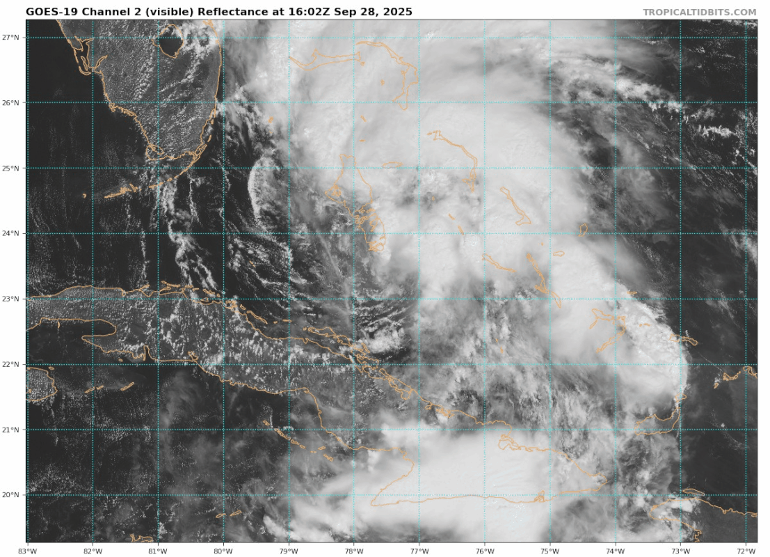
Looking much better this evening with that convection near the center expanding & a more distinct curved-band presentation. Forecast to reach 45 kts by 6z & gradually intensify thereafter on the NHC's 21z advisory...it'll be interesting to see whether Imelda overperforms in the short-term. HWRF and both HAFS models show somewhat faster intensification in the next 24 hours, with all three taking Imelda below 990 hPa by 12z Monday.
1 likes
-
cycloneye
- Admin
- Posts: 149278
- Age: 69
- Joined: Thu Oct 10, 2002 10:54 am
- Location: San Juan, Puerto Rico
Re: NATL: IMELDA - Tropical Storm - Discussion
Teban54 wrote:Well, here's our I storm.
Hopefully, despite the certain short-term impacts in the Bahamas, it will be like the last I storm (Isaac 2024) and overperform as a hurricane heading OTS afterwards. But Bermuda is still in the way, and I personally wouldn't even write off the possibility of Imelda looping back at some point (even something like the NE CONUS).
The final outcome is still not too clear yet. Is going OTS, but there may be some meaendering in the Subtropical Atlantic.
1 likes
Visit the Caribbean-Central America Weather Thread where you can find at first post web cams,radars
and observations from Caribbean basin members Click Here
and observations from Caribbean basin members Click Here
Re: NATL: IMELDA - Tropical Storm - Discussion
A bit mode deep convection close to the LLC. While the biggest towers are still east of there, the huge band to the E-SE that had been dominating all afternoon has subsided somewhat.

3 likes
TC naming lists: retirements and intensity
Most aggressive Advisory #1's in North Atlantic (cr. kevin for starting the list)
Most aggressive Advisory #1's in North Atlantic (cr. kevin for starting the list)
Re: NATL: IMELDA - Tropical Storm - Discussion
VDM reports Imelda has a partial eyewall, open to the SE. Flight-level winds are also up to 46 kts. Looks like she might be organising a bit faster now.
6 likes

Re: NATL: IMELDA - Tropical Storm - Discussion
Fast moving VHT on the northern end of the eye
3 likes
-
cycloneye
- Admin
- Posts: 149278
- Age: 69
- Joined: Thu Oct 10, 2002 10:54 am
- Location: San Juan, Puerto Rico
Re: NATL: IMELDA - Tropical Storm - Discussion
2 likes
Visit the Caribbean-Central America Weather Thread where you can find at first post web cams,radars
and observations from Caribbean basin members Click Here
and observations from Caribbean basin members Click Here
-
Sciencerocks
- Category 5
- Posts: 10181
- Age: 40
- Joined: Thu Jul 06, 2017 1:51 am


Re: NATL: IMELDA - Tropical Storm - Discussion
6z Best Track:
AL, 09, 2025092906, , BEST, 0, 251N, 771W, 40, 996, TS...
For the sake of comparison, here's the 0z Best Track:
AL, 09, 2025092900, , BEST, 0, 246N, 771W, 35, 998, TS...
AL, 09, 2025092906, , BEST, 0, 251N, 771W, 40, 996, TS...
For the sake of comparison, here's the 0z Best Track:
AL, 09, 2025092900, , BEST, 0, 246N, 771W, 35, 998, TS...
0 likes

Re: NATL: IMELDA - Tropical Storm - Discussion
Looks like that LL vort in the GOM got blocked so no tug on Imelda.
Humberto has the dance card.
Clearly Imelda is out to sea and CONUS has dodged a bullet.
Humberto has the dance card.
Clearly Imelda is out to sea and CONUS has dodged a bullet.
1 likes
-
cycloneye
- Admin
- Posts: 149278
- Age: 69
- Joined: Thu Oct 10, 2002 10:54 am
- Location: San Juan, Puerto Rico
Re: NATL: IMELDA - Tropical Storm - Discussion
0 likes
Visit the Caribbean-Central America Weather Thread where you can find at first post web cams,radars
and observations from Caribbean basin members Click Here
and observations from Caribbean basin members Click Here

Re: NATL: IMELDA - Tropical Storm - Discussion
Interesting how the NHC talks about a sting jet developing as it accelerates to the east. We had the same thing occur for Humberto ‘19, which was on an eerily similar track:

Hopefully this one isn’t a MH on approach, but I definitely think we could see a strengthening cat 2. Better start prepping.
Hopefully this one isn’t a MH on approach, but I definitely think we could see a strengthening cat 2. Better start prepping.
4 likes
Igor 2010, Sandy 2012, Fay 2014, Gonzalo 2014, Joaquin 2015, Nicole 2016, Humberto 2019, Imelda 2025
I am only a tropical weather enthusiast. My predictions are not official and may or may not be backed by sound meteorological data. For official information, please refer to the NHC and NWS products.
I am only a tropical weather enthusiast. My predictions are not official and may or may not be backed by sound meteorological data. For official information, please refer to the NHC and NWS products.

Re: NATL: IMELDA - Tropical Storm - Discussion
Kazmit wrote:Interesting how the NHC talks about a sting jet developing as it accelerates to the east. We had the same thing occur for Humberto ‘19, which was on an eerily similar track:
https://upload.wikimedia.org/wikipedia/commons/e/e0/Humberto_2019_path.png
Hopefully this one isn’t a MH on approach, but I definitely think we could see a strengthening cat 2. Better start prepping.
I'm just a lurker and weather nerd so can someone explain to me, so that I can understand, what is going to cause Imelda to make this
90 degree turn OTS. If it's Humberto, how is it tugging on Imelda when they are basically rotating in the same direction, if anything I
would think the stronger storm would push the weaker one more to the west.
0 likes
-
wxman57

- Moderator-Pro Met

- Posts: 23172
- Age: 68
- Joined: Sat Jun 21, 2003 8:06 pm
- Location: Houston, TX (southwest)
Re: NATL: IMELDA - Tropical Storm - Discussion
It will not impact the east U.S. coast, with the exception of some waves. Since the wind fetch will be moving to the east, away from the U.S, the waves will not be as large. It's certainly going to impact Bermuda.
1 likes
-
wxman57
- Moderator-Pro Met
- Posts: 23172
- Age: 68
- Joined: Sat Jun 21, 2003 8:06 pm
- Location: Houston, TX (southwest)
Re: NATL: IMELDA - Tropical Storm - Discussion
hipshot wrote:I'm just a lurker and weather nerd so can someone explain to me, so that I can understand, what is going to cause Imelda to make this
90 degree turn OTS. If it's Humberto, how is it tugging on Imelda when they are basically rotating in the same direction, if anything I
would think the stronger storm would push the weaker one more to the west.
Prior to tomorrow, Humberto is producing a steering current from north to south on its western side, causing Imelda to slow down. Once Humberto passes Imelda a little bit more, the jet stream will dip south in Humberto's wake. It is this WSW-ENE jet stream that carries Imelda off to the east-northeast. Humberto isn't pulling on Imelda.
4 likes
Re: NATL: IMELDA - Tropical Storm - Discussion
wxman57 wrote:hipshot wrote:I'm just a lurker and weather nerd so can someone explain to me, so that I can understand, what is going to cause Imelda to make this
90 degree turn OTS. If it's Humberto, how is it tugging on Imelda when they are basically rotating in the same direction, if anything I
would think the stronger storm would push the weaker one more to the west.
Prior to tomorrow, Humberto is producing a steering current from north to south on its western side, causing Imelda to slow down. Once Humberto passes Imelda a little bit more, the jet stream will dip south in Humberto's wake. It is this WSW-ENE jet stream that carries Imelda off to the east-northeast. Humberto isn't pulling on Imelda.
Thanks Wxman, that makes perfect since. Any chance the jet stream backs up to the north.
0 likes
Who is online
Users browsing this forum: No registered users and 55 guests