NATL: IMELDA - Post-Tropical - Discussion
Moderator: S2k Moderators
-
MEANINGLESS_NUMBERS
- Category 2

- Posts: 503
- Joined: Mon Nov 02, 2020 1:43 pm
Re: NATL: IMELDA - Hurricane - Discussion
Empty shelves in the liquor store this morning. We are getting ready!
0 likes
Emily '87, Felix '95, Gert '99, Fabian '03, Humberto '19, Paulette '20, Teddy '20, Fiona '22, Lee '23, Ernesto '24, Humberto/Imelda '25

Re: NATL: IMELDA - Hurricane - Discussion
Hurricane Imelda is here.
Hurricane Imelda Intermediate Advisory Number 15A
NWS National Hurricane Center Miami FL AL092025
800 AM EDT Tue Sep 30 2025
...IMELDA BECOMES A HURRICANE...
SUMMARY OF 800 AM EDT...1200 UTC...INFORMATION
----------------------------------------------
LOCATION...29.0N 76.9W
ABOUT 180 MI...290 KM N OF GREAT ABACO ISLAND
ABOUT 755 MI...1215 KM WSW OF BERMUDA
MAXIMUM SUSTAINED WINDS...75 MPH...120 KM/H
PRESENT MOVEMENT...NE OR 35 DEGREES AT 7 MPH...11 KM/H
MINIMUM CENTRAL PRESSURE...980 MB...28.94 INCHES
2 likes
-
cheezyWXguy

- Category 5

- Posts: 6281
- Joined: Mon Feb 13, 2006 12:29 am
- Location: Dallas, TX
Re: NATL: IMELDA - Hurricane - Discussion
Shocking that they found justification for an upgrade. This is up there with Earl ‘98 as ugliest hurricane ever
0 likes
Re: NATL: IMELDA - Hurricane - Discussion
The recon pass found 982 mb with 10 kt wind with the dropsonde -> 981 mb. The minimum extrapolated pressure found was 981.1 mb. Maybe the NHC thinks recon just missed the exact center of Imelda, which is why they went with 980 mb. Peak FL winds of 77 kt were found which usually translates to ~70 kt at the surface. Since the winds weren't found directly in the eyewall but a bit farther away I think they used the 0.85 outer vortex conversion instead of the usual 0.90 eyewall conversion. This results in 65 kt at the surface.

5 likes
-
TallyTracker
- Category 2
- Posts: 787
- Joined: Thu Oct 11, 2018 2:46 pm
Re: NATL: IMELDA - Hurricane - Discussion
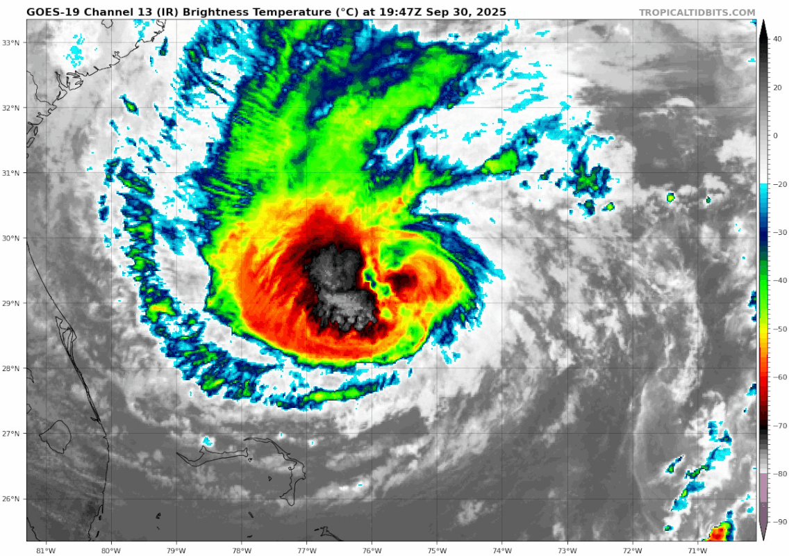
I woke up surprised to see Hurricane Imelda. I thought it must have greatly improved in organization after looking terrible last night. There is more deep convection but it continues to look like crap. Very surprised it has continued to deepen with that poor organization. I wonder if the baroclinic forcing is already beginning to occur.
0 likes
Fran '96, Georges '98, Gordon '00, Gabrielle '01, Charley '04, Frances '04, Jeanne '04, Barry '07, Fay '08, Debby '12, Matthew '16, Emily '17, Irma '17, Michael ‘18, Elsa ‘21, Fred ‘21, Mindy ‘21, Nicole ‘22, Idalia ‘23, Debby ‘24, Helene ‘24
-
wxman57

- Moderator-Pro Met

- Posts: 23172
- Age: 68
- Joined: Sat Jun 21, 2003 8:06 pm
- Location: Houston, TX (southwest)
Re: NATL: IMELDA - Hurricane - Discussion
Strong WSW wind shear is hitting both storms. Relative shear on Imelda should drop tomorrow, which may allow it to look more like a hurricane before it passes right over Bermuda.
3 likes
Re: NATL: IMELDA - Hurricane - Discussion
Wow, despite the way it looks recon found 87 kt peak FL winds. Even with the 0.85 conversion factor accounting for the measurement being farther away from the eyewall, this is sufficient for an upgrade to 75 kt.
2 likes
Re: NATL: IMELDA - Hurricane - Discussion
NHC goes with 70 kt at 11am, but they do explicitly mention that this may be conservative. Guess they're also understandibly a bit hesistant to up the wind speed considering how Imelda looks right now.
Hurricane Imelda Discussion Number 16
NWS National Hurricane Center Miami FL AL092025
1100 AM EDT Tue Sep 30 2025
Imelda is gradually becoming better organized, with deep convection
increasing near the center and banding features becoming more
evident. An Air Force Hurricane Hunter aircraft measured
flight-level winds that supported hurricane strength, although the
central pressure has not yet fallen very much. The current
intensity is set, perhaps conservatively, at 70 kt.
1 likes
-
cycloneye

- Admin

- Posts: 149275
- Age: 69
- Joined: Thu Oct 10, 2002 10:54 am
- Location: San Juan, Puerto Rico
Re: NATL: IMELDA - Hurricane - Discussion
0 likes
Visit the Caribbean-Central America Weather Thread where you can find at first post web cams,radars
and observations from Caribbean basin members Click Here
and observations from Caribbean basin members Click Here
-
Sciencerocks
- Category 5
- Posts: 10181
- Age: 40
- Joined: Thu Jul 06, 2017 1:51 am

-
galaxy401

- Category 5
- Posts: 2446
- Age: 30
- Joined: Sat Aug 25, 2012 9:04 pm
- Location: Casa Grande, Arizona
Re: NATL: IMELDA - Tropical Storm - Discussion
emeraldislenc wrote:This storm looks very weak and I don't see it making it to
A hurricane anytime soon!
Didn't even take 12 hours to become a hurricane.
7 likes
Got my eyes on moving right into Hurricane Alley: Florida.
-
HurricaneBelle

- S2K Supporter

- Posts: 1209
- Joined: Sun Aug 27, 2006 6:12 pm
- Location: Clearwater, FL
Re: NATL: IMELDA - Hurricane - Discussion
wxman57 wrote:Strong WSW wind shear is hitting both storms. Relative shear on Imelda should drop tomorrow, which may allow it to look more like a hurricane before it passes right over Bermuda.
One Battle After Another isn't just the #1 hit at the box office, it's Bermuda for the next few days.
2 likes
-
cheezyWXguy
- Category 5
- Posts: 6281
- Joined: Mon Feb 13, 2006 12:29 am
- Location: Dallas, TX
Re: NATL: IMELDA - Hurricane - Discussion
Imelda’s made some pretty solid improvements from this morning, seems to be building a core from the ground up at the moment
3 likes
-
Sciencerocks
- Category 5
- Posts: 10181
- Age: 40
- Joined: Thu Jul 06, 2017 1:51 am

-
wxman57
- Moderator-Pro Met
- Posts: 23172
- Age: 68
- Joined: Sat Jun 21, 2003 8:06 pm
- Location: Houston, TX (southwest)
Re: NATL: IMELDA - Hurricane - Discussion
All models now have Imelda absorbing Humberto tomorrow evening. Great big ET storm after it passes Bermuda.
4 likes
-
Sciencerocks
- Category 5
- Posts: 10181
- Age: 40
- Joined: Thu Jul 06, 2017 1:51 am


Re: NATL: IMELDA - Hurricane - Discussion
Imelda is starting to look like a more conventional hurricane, with rotating hot towers around an eye.
4 likes
TC naming lists: retirements and intensity
Most aggressive Advisory #1's in North Atlantic (cr. kevin for starting the list)
Most aggressive Advisory #1's in North Atlantic (cr. kevin for starting the list)

Re: NATL: IMELDA - Hurricane - Discussion
An actual eye? Not a dry slot?

5 likes
Igor 2010, Sandy 2012, Fay 2014, Gonzalo 2014, Joaquin 2015, Nicole 2016, Humberto 2019, Imelda 2025
I am only a tropical weather enthusiast. My predictions are not official and may or may not be backed by sound meteorological data. For official information, please refer to the NHC and NWS products.
I am only a tropical weather enthusiast. My predictions are not official and may or may not be backed by sound meteorological data. For official information, please refer to the NHC and NWS products.
-
storm_in_a_teacup

- Category 1

- Posts: 496
- Age: 33
- Joined: Wed Aug 16, 2017 5:01 pm
- Location: Huntsville, Alabama (originally from Houston)
- Contact:
Re: NATL: IMELDA - Hurricane - Discussion
wxman57 wrote:All models now have Imelda absorbing Humberto tomorrow evening. Great big ET storm after it passes Bermuda.
Ah, so we get to see the "hurricane cannibalism" I've seen people make YouTube videos about
2 likes
I know I can't straddle the atmosphere...just a tiny storm in your teacup, girl.
-
OuterBanker
- S2K Supporter
- Posts: 1761
- Joined: Wed Feb 26, 2003 10:53 am
- Location: Nags Head, NC
- Contact:
Re: NATL: IMELDA - Hurricane - Discussion
Well, it seems the OBX made the national news again tonight. Another condemned five homes washed out to sea today on Hatteras Island.
Wind and waves pounding the shore again. 32 kt winds now at Jennetts pier. Wind advisories gusts to 45 through tomorrow.
Bermuda will have a double strike, yet we probably won’t hear of any real damage.
The reason is simple. Here we build multi-million dollar homes out of sticks.
There they are made of bricks.
The big bad wolf lives just up the street.
4 likes
Who is online
Users browsing this forum: No registered users and 130 guests