2025 Global Model Runs Discussion (Out thru day 16)
Moderator: S2k Moderators
Forum rules

The posts in this forum are NOT official forecasts and should not be used as such. They are just the opinion of the poster and may or may not be backed by sound meteorological data. They are NOT endorsed by any professional institution or STORM2K. For official information, please refer to products from the National Hurricane Center and National Weather Service.

Re: 2025 Global Model Runs Discussion (Out thru day 16)
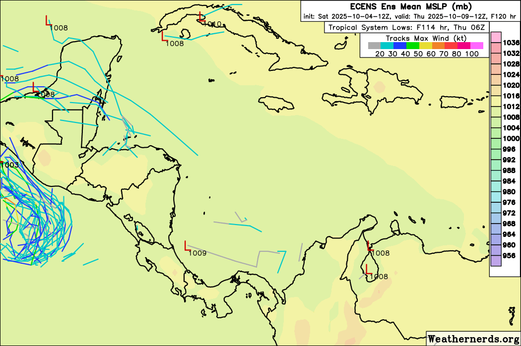
Is everyone asleep at the wheel here? The 18z GFS has the makings of what looks like a possible central American Gyre around mid month. That not saying much for that model but its more than what we have seen for model storms in that basin this season
4 likes
-
SFLcane

- S2K Supporter

- Posts: 10281
- Age: 48
- Joined: Sat Jun 05, 2010 1:44 pm
- Location: Lake Worth Florida
Re: 2025 Global Model Runs Discussion (Out thru day 16)
Season not over...most threats to the conus have formed right in our backyard last few yrs. Just something to think about.

10 likes
Re: 2025 Global Model Runs Discussion (Out thru day 16)
SFLcane wrote:Season not over...most threats to the conus have formed right in our backyard last few yrs. Just something to think about.
https://i.imgur.com/2ZnFm3y.png
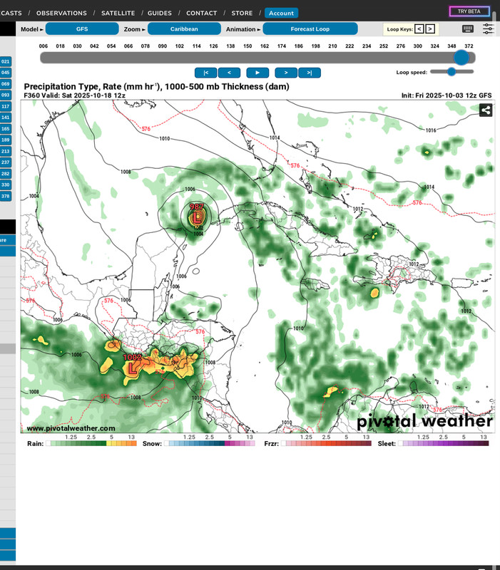
Interesting enough the GFS has a similar system in the same area at the same timeframe.
1 likes


Re: 2025 Global Model Runs Discussion (Out thru day 16)
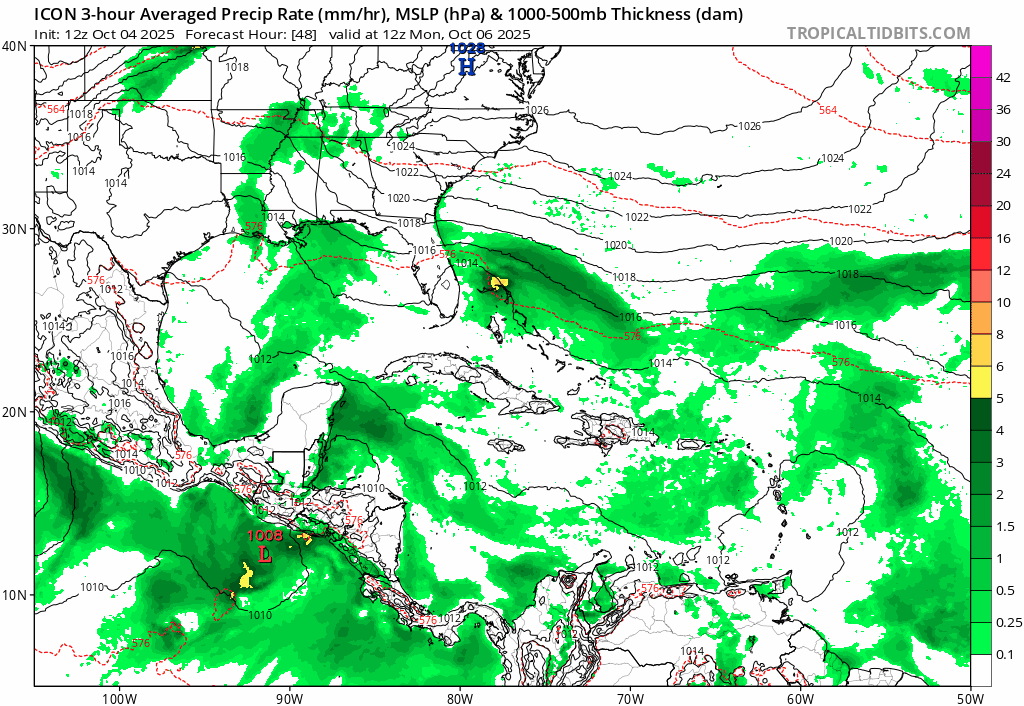
12z ICON has a TS that stalls near SFL for 2+ days:
3 likes
TC naming lists: retirements and intensity
Most aggressive Advisory #1's in North Atlantic (cr. kevin for starting the list)
Most aggressive Advisory #1's in North Atlantic (cr. kevin for starting the list)
Re: 2025 Global Model Runs Discussion (Out thru day 16)
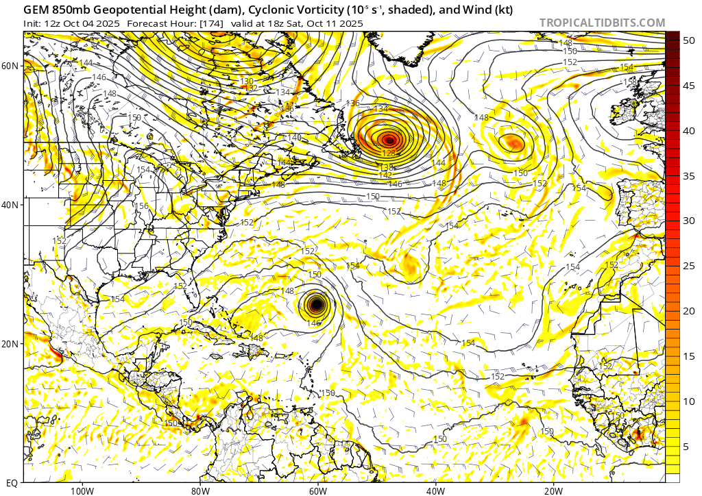
In addition to the 10/60 AOI (the recurving hurricane in this GIF), 12z CMC tries to develop yet another MDR TC at the end of this run. There's also a weak, quick Caribbean spin-up that shoots NE.
0 likes
TC naming lists: retirements and intensity
Most aggressive Advisory #1's in North Atlantic (cr. kevin for starting the list)
Most aggressive Advisory #1's in North Atlantic (cr. kevin for starting the list)
-
SFLcane
- S2K Supporter
- Posts: 10281
- Age: 48
- Joined: Sat Jun 05, 2010 1:44 pm
- Location: Lake Worth Florida
Re: 2025 Global Model Runs Discussion (Out thru day 16)
Oh oh… 12z eps
Curious how this evolves.
Curious how this evolves.
3 likes
-
Weathertracker96
- Tropical Storm

- Posts: 150
- Joined: Mon Oct 16, 2023 3:41 pm
Re: 2025 Global Model Runs Discussion (Out thru day 16)
What timeframe is that? Just wondering so I can be on the look out
2 likes
-
crownweather

- S2K Supporter
- Posts: 602
- Age: 51
- Joined: Sat Aug 12, 2006 9:21 am
- Location: Sturbridge, Massachusetts
- Contact:
Re: 2025 Global Model Runs Discussion (Out thru day 16)
Weathertracker96 wrote:
What timeframe is that? Just wondering so I can be on the look out
Right around the 15th of this month.
Sent from my iPhone using Tapatalk
1 likes
Rob Lightbown
Crown Weather Services
https://crownweather.com
Crown Weather Services
https://crownweather.com
-
floridasun
- Tropical Storm
- Posts: 245
- Joined: Tue Sep 14, 2021 3:59 pm
-
SFLcane
- S2K Supporter
- Posts: 10281
- Age: 48
- Joined: Sat Jun 05, 2010 1:44 pm
- Location: Lake Worth Florida
Re: 2025 Global Model Runs Discussion (Out thru day 16)
crownweather wrote:Weathertracker96 wrote:
What timeframe is that? Just wondering so I can be on the look out
Right around the 15th of this month.
Sent from my iPhone using Tapatalk
Hi yes sorry about 7-10 days out. It’s about the only area left that could bring impacts to the conus.
So we watch!
1 likes
-
Weathertracker96
- Tropical Storm
- Posts: 150
- Joined: Mon Oct 16, 2023 3:41 pm
Re: 2025 Global Model Runs Discussion (Out thru day 16)
crownweather wrote:Weathertracker96 wrote:
What timeframe is that? Just wondering so I can be on the look out
Right around the 15th of this month.
Thanks for answering. Will be interesting to see how this plays out. If conditions are favorable couple with water temps/steering, this could be a problem.
Sent from my iPhone using Tapatalk
0 likes
-
DorkyMcDorkface

- Category 4

- Posts: 984
- Age: 28
- Joined: Mon Sep 30, 2019 1:32 pm
- Location: Mid-Atlantic
Re: 2025 Global Model Runs Discussion (Out thru day 16)
SFLcane wrote:https://i.postimg.cc/RVNbxvsg/IMG-1303.gif
If there's any US threats to be had for the remainder of the year they would almost exclusively be from CAG action that gets pulled into the Eastern Gulf, so it's worth monitoring to see if something does indeed get going down there as the MJO makes its return to this part of the world (especially with -ENSO)
3 likes
Please note the thougths expressed by this account are solely those of the user and are from a hobbyist perspective. For more comprehensive analysis, consult an actual professional meteorologist or meteorology agency.
Floyd 1999 | Isabel 2003 | Hanna 2008 | Irene 2011 | Sandy 2012 | Isaias 2020

Re: 2025 Global Model Runs Discussion (Out thru day 16)
DorkyMcDorkface wrote:SFLcane wrote:https://i.postimg.cc/RVNbxvsg/IMG-1303.gif
If there's any US threats to be had for the remainder of the year they would almost exclusively be from CAG action that gets pulled into the Eastern Gulf, so it's worth monitoring to see if something does indeed get going down there as the MJO makes its return to this part of the world (especially with -ENSO)
My thoughts all season is any threat to GoM or Florida will would come the West Caribbean, not from the MDR or even a "home grown" west Atlantic system given where the Atlantic high set up this year, being more of an Azores high than the traditional Bermuda high.
Unlikely we will see a CONUS impact any other way, but not impossible. Nichole a few years ago as was the Yankee Hurricane of 1935 were exceptions of a late season Florida impact coming off the Atlantic.
Its been a wierd season in my opinion so I wouldn't be surprised if we get a late season surprise thst does something like that.
While the GFS ensemble "heat map" is popping 7 days++ for a possible CAG/ West Caribbean system, keep in mind it has done this many times this season(as usual) and has yet to be right. Granted the Canadian alao is hinting at something but it too has had a few phantom storms this season . Until the Euro ensembles start to show some activity over a few runs(vs one or 2 outlier runs) that confirms the others, I will remain skeptical.
4 likes
Re: 2025 Global Model Runs Discussion (Out thru day 16)
Jr0d wrote:DorkyMcDorkface wrote:SFLcane wrote:https://i.postimg.cc/RVNbxvsg/IMG-1303.gif
If there's any US threats to be had for the remainder of the year they would almost exclusively be from CAG action that gets pulled into the Eastern Gulf, so it's worth monitoring to see if something does indeed get going down there as the MJO makes its return to this part of the world (especially with -ENSO)
My thoughts all season is any threat to GoM or Florida will would come the West Caribbean, not from the MDR or even a "home grown" west Atlantic system given where the Atlantic high set up this year, being more of an Azores high than the traditional Bermuda high.
Unlikely we will see a CONUS impact any other way, but not impossible. Nichole a few years ago as was the Yankee Hurricane of 1935 were exceptions of a late season Florida impact coming off the Atlantic.
Its been a wierd season in my opinion so I wouldn't be surprised if we get a late season surprise thst does something like that.
While the GFS ensemble "heat map" is popping 7 days++ for a possible CAG/ West Caribbean system, keep in mind it has done this many times this season(as usual) and has yet to be right. Granted the Canadian alao is hinting at something but it too has had a few phantom storms this season . Until the Euro ensembles start to show some activity over a few runs(vs one or 2 outlier runs) that confirms the others, I will remain skeptical.
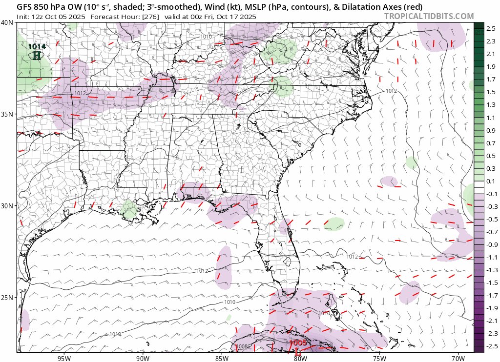
The Euro ensembles have looked quite active in the W Caribbean for most of next week just like the GFS ensembles. The latest Euro Weeklies are showing well above climo TC activity in the W Caribbean the week of 10/13-19 (about highest of any run yet) and still elevated vs climo the week of 10/20-26 (if I were in the FL pen., I’d be a bit concerned for midmonth).
4 likes
Personal Forecast Disclaimer:
The posts in this forum are NOT official forecasts and should not be used as such. They are just the opinion of the poster and may or may not be backed by sound meteorological data. They are NOT endorsed by any professional institution or storm2k.org. For official information, please refer to the NHC and NWS products.
The posts in this forum are NOT official forecasts and should not be used as such. They are just the opinion of the poster and may or may not be backed by sound meteorological data. They are NOT endorsed by any professional institution or storm2k.org. For official information, please refer to the NHC and NWS products.
-
KeysRedWine
- Tropical Low

- Posts: 11
- Age: 42
- Joined: Thu Sep 19, 2024 12:30 pm
- Location: Summerland Key, FL
Re: 2025 Global Model Runs Discussion (Out thru day 16)
LarryWx wrote:Jr0d wrote:DorkyMcDorkface wrote:If there's any US threats to be had for the remainder of the year they would almost exclusively be from CAG action that gets pulled into the Eastern Gulf, so it's worth monitoring to see if something does indeed get going down there as the MJO makes its return to this part of the world (especially with -ENSO)
My thoughts all season is any threat to GoM or Florida will would come the West Caribbean, not from the MDR or even a "home grown" west Atlantic system given where the Atlantic high set up this year, being more of an Azores high than the traditional Bermuda high.
Unlikely we will see a CONUS impact any other way, but not impossible. Nichole a few years ago as was the Yankee Hurricane of 1935 were exceptions of a late season Florida impact coming off the Atlantic.
Its been a wierd season in my opinion so I wouldn't be surprised if we get a late season surprise thst does something like that.
While the GFS ensemble "heat map" is popping 7 days++ for a possible CAG/ West Caribbean system, keep in mind it has done this many times this season(as usual) and has yet to be right. Granted the Canadian alao is hinting at something but it too has had a few phantom storms this season . Until the Euro ensembles start to show some activity over a few runs(vs one or 2 outlier runs) that confirms the others, I will remain skeptical.
The Euro ensembles have looked quite active in the W Caribbean for most of next week just like the GFS ensembles. The latest Euro Weeklies are showing well above climo TC activity in the W Caribbean the week of 10/13-19 (about highest of any run yet) and still elevated vs climo the week of 10/20-26 (if I were in the FL pen., I’d be a bit concerned for midmonth).
Please keep us Florida people posted, and thank you for your regular updates.
2 likes
-
SFLcane
- S2K Supporter
- Posts: 10281
- Age: 48
- Joined: Sat Jun 05, 2010 1:44 pm
- Location: Lake Worth Florida
Re: 2025 Global Model Runs Discussion (Out thru day 16)
GFS with a 1999 Irene scenario for Southeast Florida.
0 likes
-
floridasun
- Tropical Storm
- Posts: 245
- Joined: Tue Sep 14, 2021 3:59 pm
Re: 2025 Global Model Runs Discussion (Out thru day 16)
wont happen my birthday timeSFLcane wrote:GFS with a 1999 Irene scenario for Southeast Florida.
https://i.postimg.cc/g0Jrpmth/IMG-1308.gif
1 likes

Re: 2025 Global Model Runs Discussion (Out thru day 16)
SFLcane wrote:GFS with a 1999 Irene scenario for Southeast Florida.
https://i.postimg.cc/g0Jrpmth/IMG-1308.gif
I have more faith in the 1999 AVN/MRF (Precursor GFS) run.
1 likes
The following post is NOT an official forecast and should not be used as such. It is just the opinion of the poster and may or may not be backed by sound meteorological data. It is NOT endorsed by any professional institution including storm2k.org For Official Information please refer to the NHC and NWS products.
Who is online
Users browsing this forum: mixedDanilo.E and 89 guests