
2025 Global Model Runs Discussion (Out thru day 16)
Moderator: S2k Moderators
Forum rules

The posts in this forum are NOT official forecasts and should not be used as such. They are just the opinion of the poster and may or may not be backed by sound meteorological data. They are NOT endorsed by any professional institution or STORM2K. For official information, please refer to products from the National Hurricane Center and National Weather Service.
-
TomballEd
- Category 5

- Posts: 1260
- Age: 62
- Joined: Wed Aug 16, 2023 4:52 pm
- Location: Spring/Klein area, not Tomball
Re: 2025 Global Model Runs Discussion (Out thru day 16)
Besides the possible subtropical system off the East Coast, the GFS ensembles are not alone on Caribbean development. GFS family has company from Canadian and European.
2 likes
Re: 2025 Global Model Runs Discussion (Out thru day 16)
Where's the subtropical thing coming from?
Satellite, the area east of the Bahamas, or that spinning area off the NE tip of the Caribbean? (or both)
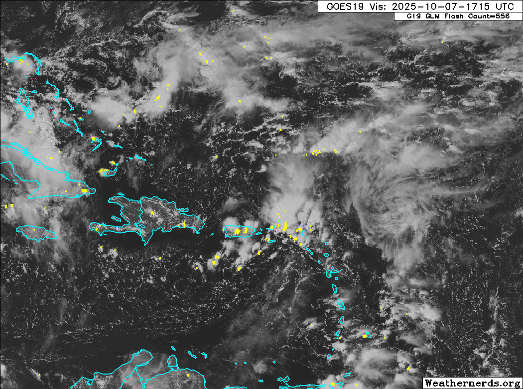

Satellite, the area east of the Bahamas, or that spinning area off the NE tip of the Caribbean? (or both)
0 likes

Re: 2025 Global Model Runs Discussion (Out thru day 16)
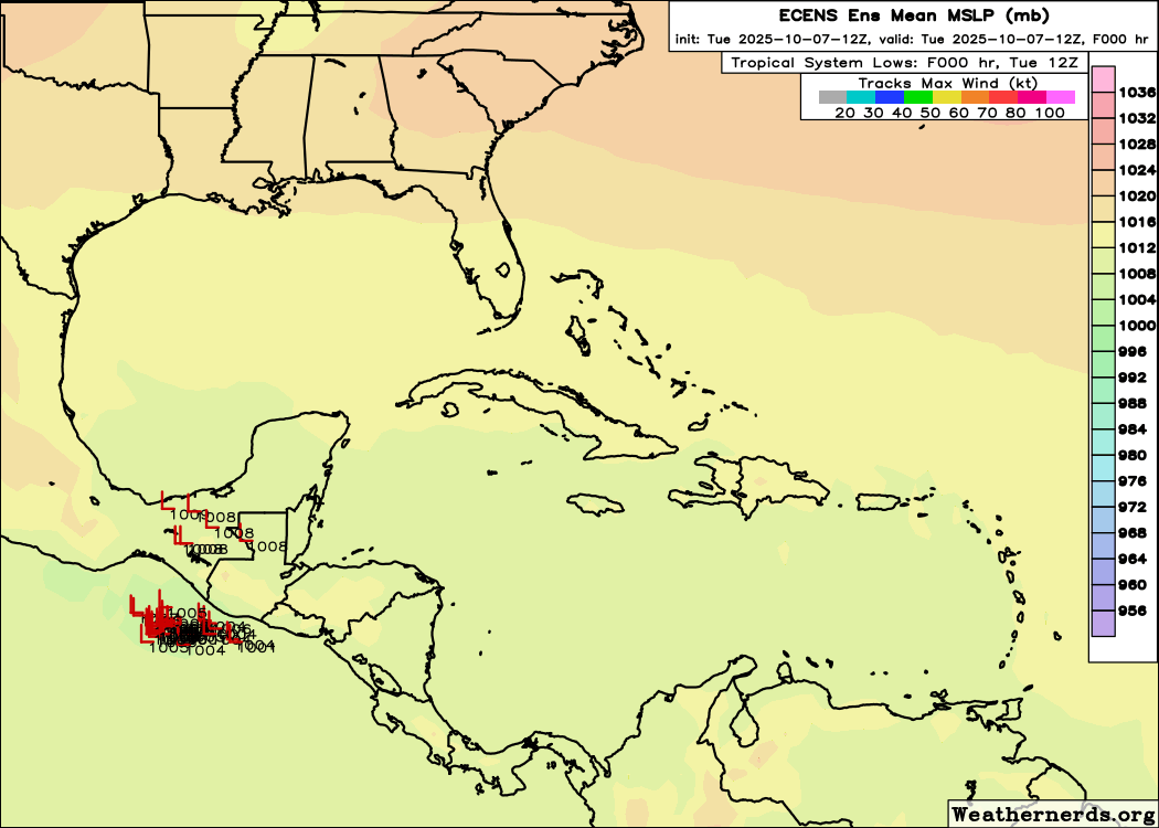
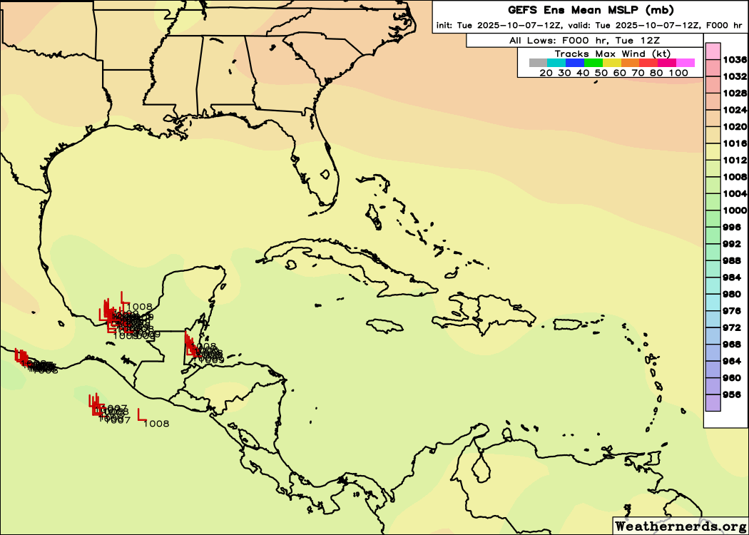
Caribbean signal on the 12z ensembles, EPS (top) and GEFS (bottom). Both signals are weak, but non-zero. I'd even say that the EPS signal is stronger in average intensity.
1 likes
TC naming lists: retirements and intensity
Most aggressive Advisory #1's in North Atlantic (cr. kevin for starting the list)
Most aggressive Advisory #1's in North Atlantic (cr. kevin for starting the list)
-
MarioProtVI
- Category 5
- Posts: 1034
- Age: 24
- Joined: Sun Sep 29, 2019 7:33 pm
- Location: New Jersey
Re: 2025 Global Model Runs Discussion (Out thru day 16)
I’m very skeptical anything will come out of the WCarib given this weekend’s East Coast system will be meandering and drifting south off the coast. Models have strong shear from the resultant trough axis basically stringing out anything that attempts to form there from late this weekend until about the 18th so unless I see a marked increase in support this just seems like model shenanigans. By that time IIRC the MJO will be moving out and intraseasonal forcing tails off dramatically afterward with perhaps a small chance in November. If the Atlantic doesn’t produce much at all after Jerry then it’s pretty much a wrap for this season IMO.
2 likes
Re: 2025 Global Model Runs Discussion (Out thru day 16)
BobHarlem wrote:Where's the subtropical thing coming from?
Satellite, the area east of the Bahamas, or that spinning area off the NE tip of the Caribbean? (or both)
https://i.postimg.cc/VvyFJ0NT/66614589.gif
https://i.imgur.com/iM3yOu0.gif
I’d say energywise neither as it starts out mainly extratropical from shortwaves coming off the coast from the Conus.
1 likes
Personal Forecast Disclaimer:
The posts in this forum are NOT official forecasts and should not be used as such. They are just the opinion of the poster and may or may not be backed by sound meteorological data. They are NOT endorsed by any professional institution or storm2k.org. For official information, please refer to the NHC and NWS products.
The posts in this forum are NOT official forecasts and should not be used as such. They are just the opinion of the poster and may or may not be backed by sound meteorological data. They are NOT endorsed by any professional institution or storm2k.org. For official information, please refer to the NHC and NWS products.
-
AJC3

- Admin

- Posts: 4153
- Age: 62
- Joined: Tue Aug 31, 2004 7:04 pm
- Location: Ballston Spa, New York
- Contact:
Re: 2025 Global Model Runs Discussion (Out thru day 16)
LarryWx wrote:BobHarlem wrote:Where's the subtropical thing coming from?
Satellite, the area east of the Bahamas, or that spinning area off the NE tip of the Caribbean? (or both)
https://i.postimg.cc/VvyFJ0NT/66614589.gif
https://i.imgur.com/iM3yOu0.gif
I’d say energywise neither as it starts out mainly extratropical from shortwaves coming off the coast from the Conus.
Yep. It's largely in situ development off the FL/GA/SC coasts generated by those short wave troughs. There's a subtle hint (in the GFS, I didn't check other models) of a weak secondary H85 vortex that gets swept NE from the FL straits into that developing XTC off the SE US coast.

1 likes
Re: 2025 Global Model Runs Discussion (Out thru day 16)
4th of last 5 UK runs with this:
0Z UK
0Z UK
NEW TROPICAL CYCLONE FORECAST TO DEVELOP AFTER 108 HOURS
FORECAST POSITION AT T+108 : 10.0N 32.4W
LEAD CENTRAL MAXIMUM WIND
VERIFYING TIME TIME POSITION PRESSURE (MB) SPEED (KNOTS)
-------------- ---- -------- ------------- -------------
1200UTC 12.10.2025 108 10.0N 32.4W 1009 28
0000UTC 13.10.2025 120 11.2N 35.9W 1009 28
1200UTC 13.10.2025 132 13.0N 39.4W 1010 28
0000UTC 14.10.2025 144 14.5N 42.0W 1010 28
1200UTC 14.10.2025 156 16.1N 44.1W 1010 25
0000UTC 15.10.2025 168 17.8N 44.8W 1011 24
0 likes
Personal Forecast Disclaimer:
The posts in this forum are NOT official forecasts and should not be used as such. They are just the opinion of the poster and may or may not be backed by sound meteorological data. They are NOT endorsed by any professional institution or storm2k.org. For official information, please refer to the NHC and NWS products.
The posts in this forum are NOT official forecasts and should not be used as such. They are just the opinion of the poster and may or may not be backed by sound meteorological data. They are NOT endorsed by any professional institution or storm2k.org. For official information, please refer to the NHC and NWS products.
Re: 2025 Global Model Runs Discussion (Out thru day 16)
LarryWx wrote:4th of last 5 UK runs with this:
0Z UKNEW TROPICAL CYCLONE FORECAST TO DEVELOP AFTER 108 HOURS
FORECAST POSITION AT T+108 : 10.0N 32.4W
LEAD CENTRAL MAXIMUM WIND
VERIFYING TIME TIME POSITION PRESSURE (MB) SPEED (KNOTS)
-------------- ---- -------- ------------- -------------
1200UTC 12.10.2025 108 10.0N 32.4W 1009 28
0000UTC 13.10.2025 120 11.2N 35.9W 1009 28
1200UTC 13.10.2025 132 13.0N 39.4W 1010 28
0000UTC 14.10.2025 144 14.5N 42.0W 1010 28
1200UTC 14.10.2025 156 16.1N 44.1W 1010 25
0000UTC 15.10.2025 168 17.8N 44.8W 1011 24
5th of last 6 UK with this MDR TC:
NEW TROPICAL CYCLONE FORECAST TO DEVELOP AFTER 60 HOURS
FORECAST POSITION AT T+ 60 : 8.5N 21.8W
LEAD CENTRAL MAXIMUM WIND
VERIFYING TIME TIME POSITION PRESSURE (MB) SPEED (KNOTS)
-------------- ---- -------- ------------- -------------
0000UTC 11.10.2025 60 8.5N 21.8W 1009 28
1200UTC 11.10.2025 72 8.9N 26.1W 1008 29
0000UTC 12.10.2025 84 9.8N 30.0W 1008 33
1200UTC 12.10.2025 96 11.0N 33.8W 1009 30
0000UTC 13.10.2025 108 12.5N 37.3W 1009 34
1200UTC 13.10.2025 120 14.4N 40.5W 1010 33
0000UTC 14.10.2025 132 16.1N 42.6W 1010 27
1200UTC 14.10.2025 144 17.7N 43.6W 1010 21
0000UTC 15.10.2025 156 19.2N 43.6W 1010 24
1200UTC 15.10.2025 168 21.3N 42.0W 1010 25
0 likes
Personal Forecast Disclaimer:
The posts in this forum are NOT official forecasts and should not be used as such. They are just the opinion of the poster and may or may not be backed by sound meteorological data. They are NOT endorsed by any professional institution or storm2k.org. For official information, please refer to the NHC and NWS products.
The posts in this forum are NOT official forecasts and should not be used as such. They are just the opinion of the poster and may or may not be backed by sound meteorological data. They are NOT endorsed by any professional institution or storm2k.org. For official information, please refer to the NHC and NWS products.
-
TomballEd
- Category 5
- Posts: 1260
- Age: 62
- Joined: Wed Aug 16, 2023 4:52 pm
- Location: Spring/Klein area, not Tomball
Re: 2025 Global Model Runs Discussion (Out thru day 16)
ECUSA storm that forms on the tail of vorticity might get sub-tropical enough for a name.

1 likes

-
Weathertracker96
- Tropical Storm

- Posts: 150
- Joined: Mon Oct 16, 2023 3:41 pm
Re: 2025 Global Model Runs Discussion (Out thru day 16)
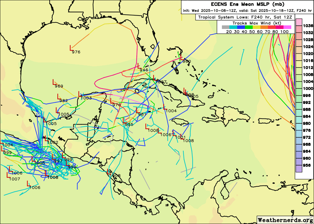
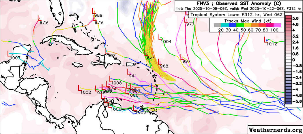
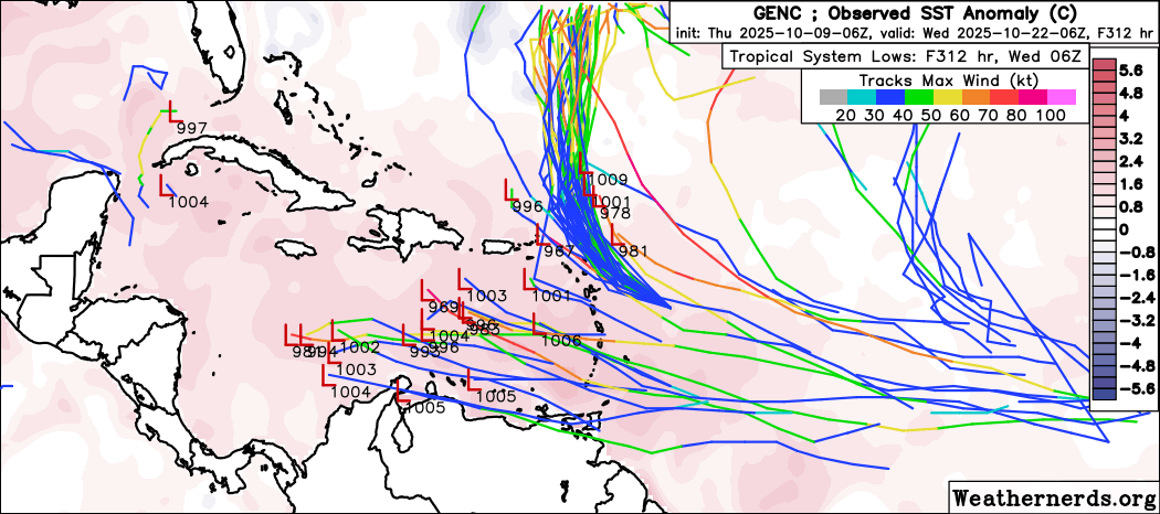
What are your thoughts on this? Some strange storm tracks. Do you think something could still form in that area?
0 likes
-
SFLcane

- S2K Supporter

- Posts: 10281
- Age: 48
- Joined: Sat Jun 05, 2010 1:44 pm
- Location: Lake Worth Florida
Re: 2025 Global Model Runs Discussion (Out thru day 16)
Weathertracker96 wrote:
What are your thoughts on this? Some strange storm tracks. Do you think something could still form in that area?
I would be surprised if something does not try to form it has 2 wks or so before the conus door i.e Cuba, FL door closes. Looks pretty favorable till about mid month mjo is about ready to move in.
1 likes
-
AnnularCane

- S2K Supporter
- Posts: 2957
- Joined: Thu Jun 08, 2006 9:18 am
- Location: Wytheville, VA
Re: 2025 Global Model Runs Discussion (Out thru day 16)
0 likes
"But it never rained rain. It never snowed snow. And it never blew just wind. It rained things like soup and juice. It snowed mashed potatoes and green peas. And sometimes the wind blew in storms of hamburgers." -- Judi Barrett, Cloudy with a Chance of Meatballs
Re: 2025 Global Model Runs Discussion (Out thru day 16)
With the CPC showing below normal precip for the next 2 weeks and dry air about to flood the field along with not much on the models it seems reasonable that the window for CONUS TC impacts is closing fast.
2 likes
-
Stormlover70
- Tropical Storm
- Posts: 194
- Age: 56
- Joined: Fri Jun 21, 2024 5:31 am
- Location: New port richey
Re: 2025 Global Model Runs Discussion (Out thru day 16)
Great news. Especially for Florida we had enough last yearpsyclone wrote:With the CPC showing below normal precip for the next 2 weeks and dry air about to flood the field along with not much on the models it seems reasonable that the window for CONUS TC impacts is closing fast.
0 likes
-
emeraldislenc
- Category 2

- Posts: 601
- Joined: Fri Aug 24, 2012 4:49 pm
- Location: Emerald Isle NC
-
Stormlover70
- Tropical Storm
- Posts: 194
- Age: 56
- Joined: Fri Jun 21, 2024 5:31 am
- Location: New port richey
Re: 2025 Global Model Runs Discussion (Out thru day 16)
I agree it is wishful thinking....still watching the Gulf and western Caribbeanemeraldislenc wrote:I think it still early to say that!
0 likes
Re: 2025 Global Model Runs Discussion (Out thru day 16)
Well, never say never in October, but the westerlies are kicking in a bit early here in Central Florida. Believe me, I’m glad if not for just a taste of fall weather, which is expected to be short lived as always here near Melbourne. Going to be a rainy couple of days with a low pressure system developing off the coast. Could be interesting. Strange season 
1 likes
-
DorkyMcDorkface

- Category 4

- Posts: 984
- Age: 28
- Joined: Mon Sep 30, 2019 1:32 pm
- Location: Mid-Atlantic
Re: 2025 Global Model Runs Discussion (Out thru day 16)
0 likes
Please note the thougths expressed by this account are solely those of the user and are from a hobbyist perspective. For more comprehensive analysis, consult an actual professional meteorologist or meteorology agency.
Floyd 1999 | Isabel 2003 | Hanna 2008 | Irene 2011 | Sandy 2012 | Isaias 2020
-
SFLcane
- S2K Supporter
- Posts: 10281
- Age: 48
- Joined: Sat Jun 05, 2010 1:44 pm
- Location: Lake Worth Florida
Re: 2025 Global Model Runs Discussion (Out thru day 16)
Ai models hinting a wave could sneak into the caribbean in about 7-10 days. The clock is ticking quickly now for the conus in terms of threats another 15-20 left before things turn hostile.
1 likes
Who is online
Users browsing this forum: mixedDanilo.E and 80 guests