


Moderator: S2k Moderators


Ubuntwo wrote:18z EC-AI actually dove south back into the Caribbean after landfall in Haiti, a first for the model. The 18z Euro and ICON both shifted NE a fair bit, though both stopped short of a landfall in Haiti before getting trapped.
Fancy1002 wrote:Ubuntwo wrote:18z EC-AI actually dove south back into the Caribbean after landfall in Haiti, a first for the model. The 18z Euro and ICON both shifted NE a fair bit, though both stopped short of a landfall in Haiti before getting trapped.
Pretty sure that diving back into the Caribbean has happened a few times over the last 3 runs.


LarryWx wrote:6Z Euro 144: significant shift NE vs 0Z 150 and 12Z 162 (which were both 150-200 miles SSW to SW of Jamaica) with the 6Z 40 miles E of Jamaica. That’s a 200-250 mile NE shift from the 0Z/12Z!
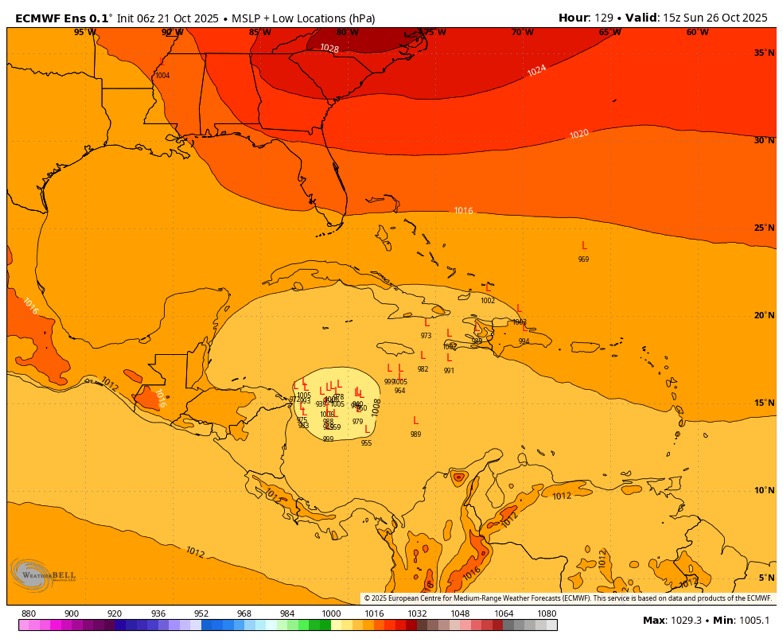
SFLcane wrote:LarryWx wrote:6Z Euro 144: significant shift NE vs 0Z 150 and 12Z 162 (which were both 150-200 miles SSW to SW of Jamaica) with the 6Z 40 miles E of Jamaica. That’s a 200-250 mile NE shift from the 0Z/12Z!
Fyi..
https://i.postimg.cc/43rqMc8M/IMG-1407.jpg

LarryWx wrote:SFLcane wrote:LarryWx wrote:6Z Euro 144: significant shift NE vs 0Z 150 and 12Z 162 (which were both 150-200 miles SSW to SW of Jamaica) with the 6Z 40 miles E of Jamaica. That’s a 200-250 mile NE shift from the 0Z/12Z!
Fyi..
https://i.postimg.cc/43rqMc8M/IMG-1407.jpg
Thanks. Yes, the 6Z Euro op is near the most NE 6Z EPS members. The large majority are 300-500 miles WSW to SW of the Euro op!
Users browsing this forum: No registered users and 168 guests


