NATL: MELISSA - Aftermath - Discussion
Moderator: S2k Moderators
NATL: INVEST 98L - Discussion (90/90)
Looks like NHC with their TWO is really slowing down future Melissa with the 7 day graphic only extending to JAM. It also isn't really showing the fast right hand hook into DR from the GFS so perhaps NHC is discounting that solution at the moment.
0 likes
-
emeraldislenc
- Category 2

- Posts: 601
- Joined: Fri Aug 24, 2012 4:49 pm
- Location: Emerald Isle NC
Re: NATL: INVEST 98L - Discussion (90/90)
I thought the graphic was were the future storm might form but not where it might go. To me that makes more sense!
2 likes
- Category5Kaiju
- Category 5

- Posts: 4344
- Joined: Thu Dec 24, 2020 12:45 pm
- Location: Seattle during the summer, Phoenix during the winter
Re: NATL: INVEST 98L - Discussion (70/90)
cycloneye wrote:There could be a possibbility that NHC issue advisories as PTC. What do the members think about that?
https://i.imgur.com/C3gP6dl.gif
Well...I think this storm is a bit tricky given how quite a few models seem to think that this isn't going to make landfall immediately but rather lumber around and stall offshore for a few days at least. Are PTCs given to systems that have a high chance of making landfall at a certain point in the upcoming days, or can that also encompass non-direct land impacts (like rainfall from outer bands)?
I'm also starting to see some rotation in that gif too, so it does look like this system is going to be named fairly soon.
3 likes
Unless explicitly stated, all information in my posts is based on my own opinions and observations. Tropical storms and hurricanes can be extremely dangerous. Refer to an accredited weather research agency or meteorologist if you need to make serious decisions regarding an approaching storm.
Re: NATL: INVEST 98L - Discussion (90/90)
ronjon wrote:Looks like NHC with their TWO is really slowing down future Melissa with the 7 day graphic only extending to JAM. It also isn't really showing the fast right hand hook into DR from the GFS so perhaps NHC is discounting that solution at the moment.
The TWO is intended to indicate areas of formation alone, not the forecast track after formation. So even if, as a hypothetical, NHC's beliefs are "70% chance that Melissa forms and moves towards Hispaniola quickly without stalling, within 7 days", the TWO still won't (or shouldn't) show a Hispaniola landfall.
4 likes
TC naming lists: retirements and intensity
Most aggressive Advisory #1's in North Atlantic (cr. kevin for starting the list)
Most aggressive Advisory #1's in North Atlantic (cr. kevin for starting the list)
Re: NATL: INVEST 98L - Discussion (90/90)
ronjon wrote:Looks like NHC with their TWO is really slowing down future Melissa with the 7 day graphic only extending to JAM. It also isn't really showing the fast right hand hook into DR from the GFS so perhaps NHC is discounting that solution at the moment.
The ONLY reason the development area is contracting is that development is imminent (90/90)...so we have a real good idea where genesis will be. that tells us nothing of what happens after genesis. It feels like we have been tracking this one for a couple months already...and we have a long way to go...oh my..
6 likes
- cycloneye
- Admin

- Posts: 149638
- Age: 69
- Joined: Thu Oct 10, 2002 10:54 am
- Location: San Juan, Puerto Rico
Re: NATL: INVEST 98L - Discussion (90/90)
00z Best Track: More slow now at 13 mph.

FORECAST TRACK FROM OFPI INITIAL HEADING/SPEED (DEG/KT):280/ 11
AL, 98, 2025102100, , BEST, 0, 141N, 688W, 35, 1007, DB

2 likes
Visit the Caribbean-Central America Weather Thread where you can find at first post web cams,radars
and observations from Caribbean basin members Click Here
and observations from Caribbean basin members Click Here
-
Sciencerocks
- Category 5

- Posts: 10186
- Age: 40
- Joined: Thu Jul 06, 2017 1:51 am
- WaveBreaking
- Category 2

- Posts: 727
- Joined: Sun Jun 30, 2024 11:33 am
- Location: US
Re: NATL: INVEST 98L - Discussion (90/90)
Sunset


1 likes
I am NOT a professional meteorologist, so take all of my posts with a grain of salt. My opinions are mine and mine alone.
-
CrazyC83
- Professional-Met

- Posts: 34316
- Joined: Tue Mar 07, 2006 11:57 pm
- Location: Deep South, for the first time!
NATL: INVEST 98L - Discussion (90/90)
The chaotic late October upper atmosphere sure adds uncertainty. It seems that two troughs will come through - one late this week, and another around the middle of next week. This looks like a blend between Michelle, Wilma and Sandy. It all depends on timing of this storm's development, intensification and the upper level features.
6 likes
Re: NATL: INVEST 98L - Discussion (90/90)
CrazyC83 wrote:The chaotic late October upper atmosphere sure adds uncertainty. It seems that two troughs will come through - one late this week, and another around the middle of next week. This looks like a blend between Michelle, Wilma and Sandy. It all depends on timing of this storm's development, intensification and the upper level features.
Do you agree that South Florida shouldn’t let their guard down just yet. I keep trying to tell some friends in the Miami area, not to dismiss the storm, but they keep saying, no I was told it would go over either Cuba or Haiti.
2 likes
Re: NATL: INVEST 98L - Discussion (90/90)
CrazyC83 wrote:The chaotic late October upper atmosphere sure adds uncertainty. It seems that two troughs will come through - one late this week, and another around the middle of next week. This looks like a blend between Michelle, Wilma and Sandy. It all depends on timing of this storm's development, intensification and the upper level features.
Fun fact: Melissa, the next name on this year's list, replaced Michelle after 2001.
3 likes
TC naming lists: retirements and intensity
Most aggressive Advisory #1's in North Atlantic (cr. kevin for starting the list)
Most aggressive Advisory #1's in North Atlantic (cr. kevin for starting the list)
- cycloneye
- Admin

- Posts: 149638
- Age: 69
- Joined: Thu Oct 10, 2002 10:54 am
- Location: San Juan, Puerto Rico
Re: NATL: INVEST 98L - Discussion (90/90)
2 likes
Visit the Caribbean-Central America Weather Thread where you can find at first post web cams,radars
and observations from Caribbean basin members Click Here
and observations from Caribbean basin members Click Here
Re: NATL: INVEST 98L - Discussion (90/90)
zzzh wrote:https://i.imgur.com/V5yI7OE.png
Looking at that, the NHC isn't going to do anything with this until recon gets out there.
2 likes
- REDHurricane
- Category 1

- Posts: 438
- Age: 28
- Joined: Sun Jul 03, 2022 2:36 pm
- Location: Northeast Pacific Ocean
Re: NATL: INVEST 98L - Discussion (90/90)
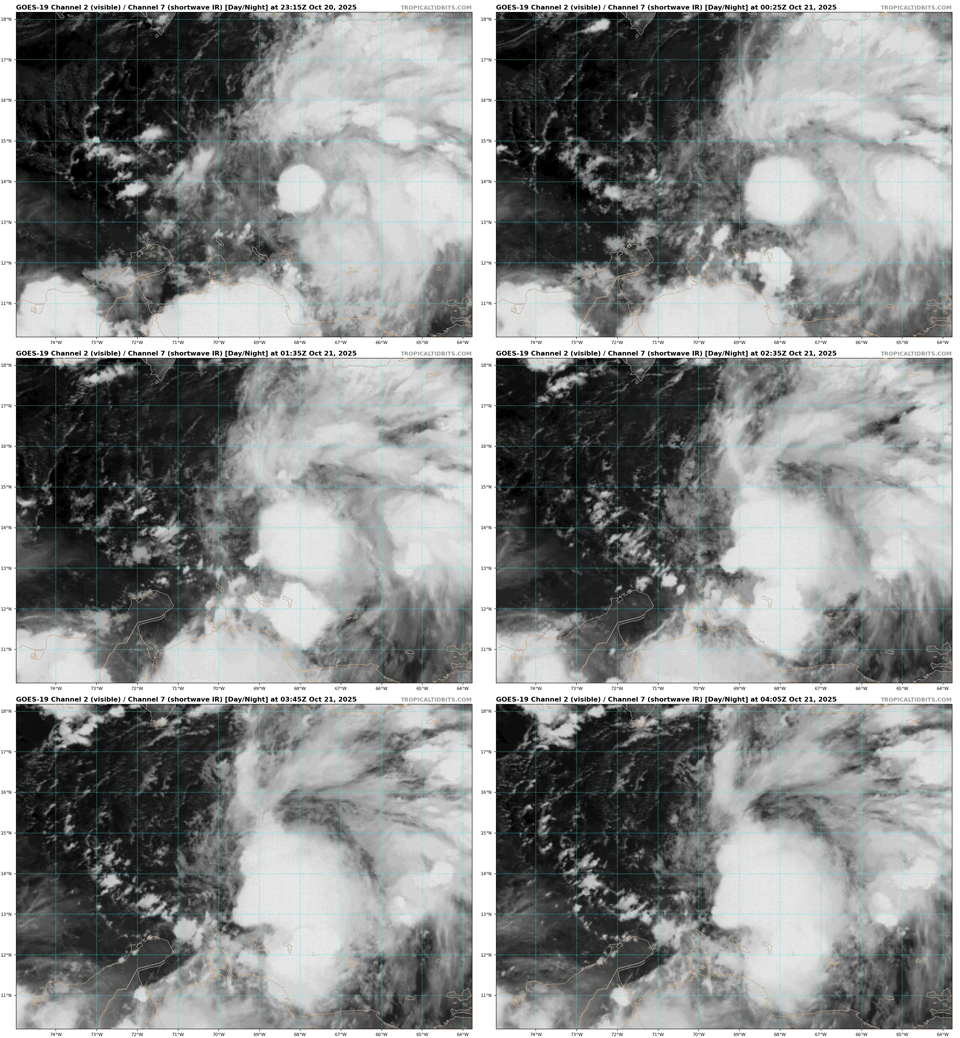
Lookin' good now, probably a soon-to-be TS if this keeps up for several more hours


4 likes
- REDHurricane
- Category 1

- Posts: 438
- Age: 28
- Joined: Sun Jul 03, 2022 2:36 pm
- Location: Northeast Pacific Ocean
Re: NATL: INVEST 98L - Discussion (90/90)
Tropical Weather Outlook
NWS National Hurricane Center Miami FL
200 AM EDT Tue Oct 21 2025
1. Caribbean Sea (AL98):
Satellite, radar, and surface observations indicate that the broad
area of low pressure over the central Caribbean Sea continues to
become better defined, with winds near 45 mph, though it still lacks
a well-defined center. Environmental conditions are forecast to
become more conducive for development, and a tropical storm is
expected to form later today while the system moves slowly over the
central Caribbean Sea. Heavy rainfall and gusty winds are possible
over portions of the ABC Islands during the next couple of days.
Interests in Puerto Rico, Hispaniola, Jamaica, and Cuba should
monitor the progress of this system as there is a risk of heavy rain
and flooding, strong winds, and rough surf later this week. For
additional information on this system, including Gale Warnings,
please see High Seas Forecasts issued by the National Weather
Service.
* Formation chance through 48 hours...high...90 percent.
* Formation chance through 7 days...high...90 percent.
0 likes
Personal Forecast Disclaimer:
The posts in this forum are NOT official forecasts and should not be used as such. They are just the opinion of the poster and may or may not be backed by sound meteorological data. They are NOT endorsed by any professional institution or storm2k.org. For official information, please refer to the NHC and NWS products.
The posts in this forum are NOT official forecasts and should not be used as such. They are just the opinion of the poster and may or may not be backed by sound meteorological data. They are NOT endorsed by any professional institution or storm2k.org. For official information, please refer to the NHC and NWS products.
Re: NATL: INVEST 98L - Discussion (90/90)
REDHurricane wrote:Lookin' good now, probably a soon-to-be TS if this keeps up for several more hours
https://media1.giphy.com/media/v1.Y2lkPTc5MGI3NjExamNoYWVjaW1sdHZsd2kwNWVjNjRrazVlMzltcmFub3hkdTRtYXh2dCZlcD12MV9pbnRlcm5hbF9naWZfYnlfaWQmY3Q9Zw/MezMN1WOViymKWJcwX/giphy.gif
Just looking at night-time IR, I'd bet a peanut butter and pickled herring sandwich
 that there now are west winds at the surface
2 likes
Andy D
(For official information, please refer to the NHC and NWS products.)
(For official information, please refer to the NHC and NWS products.)
Re: NATL: INVEST 98L - Discussion (90/90)
Sciencerocks wrote:https://imagizer.imageshack.com/img922/612/tO8VTs.gif
It appears Bonaire got slammed with thunderstorms galore for a brief period. Quite unusual for that island, whose climate has often been compared to that of a desert—ditto for the nearby isles of Aruba and Curaçao.
0 likes
Re: NATL: INVEST 98L - Discussion (90/90)
6z Best Track:
AL, 98, 2025102106, , BEST, 0, 140N, 698W, 40, 1004, DB
1 likes
Who is online
Users browsing this forum: No registered users and 56 guests


