NATL: MELISSA - Aftermath - Discussion
Moderator: S2k Moderators
NATL: MELISSA - Tropical Storm - Discussion
We'll see how the tried and true "Graveyard Of The Caribbean" plays out...
2 likes
-
Hurricane Mike
- Category 2

- Posts: 675
- Joined: Tue Apr 10, 2018 7:44 am
Re: NATL: MELISSA - Tropical Storm - Discussion
Noon Video Update on Melissa
https://www.youtube.com/watch?v=xqThhWAbolg
https://www.youtube.com/watch?v=xqThhWAbolg
0 likes

Re: NATL: INVEST 98L - Discussion (100/100)
Fancy1002 wrote:GCANE wrote:boca wrote:
How would a cut off low affect the track of future Melissa?
Fujiwhara effect
I’m wondering if the low is deep enough and Melissa takes a more western track, could the low force Melissa just barely into South Florida making a direct impact on Miami.
That'll have everything to do with the timing of both Melissa as well as the low itself. Perhaps more important though, this will largely depend on how positively tilted that trough might be (as illustrated in the Euro 210 hr. 500mb graphic), verses perhaps cutting off altogether. A progressively negative tilt to a sharp trough would far more quickly enhance a poleward turn. It always comes down to timing though.
0 likes
Andy D
(For official information, please refer to the NHC and NWS products.)
(For official information, please refer to the NHC and NWS products.)

Re: NATL: MELISSA - Tropical Storm - Discussion
I’m not sure who took it upon themselves to edit the 2025 season Wikipedia to their liking, but this is rather ominous.

0 likes
Igor 2010, Sandy 2012, Fay 2014, Gonzalo 2014, Joaquin 2015, Nicole 2016, Humberto 2019, Imelda 2025
I am only a tropical weather enthusiast. My predictions are not official and may or may not be backed by sound meteorological data. For official information, please refer to the NHC and NWS products.
I am only a tropical weather enthusiast. My predictions are not official and may or may not be backed by sound meteorological data. For official information, please refer to the NHC and NWS products.
Re: NATL: MELISSA - Tropical Storm - Discussion
Kazmit wrote:I’m not sure who took it upon themselves to edit the 2025 season Wikipedia to their liking, but this is rather ominous.
https://i.ibb.co/6RddJpvp/IMG-5447.png
That's funny - The new "Wiki forecast". Hey, props to reaching "Olga" though. I just love that name for a tropical cyclone.
1 likes
Andy D
(For official information, please refer to the NHC and NWS products.)
(For official information, please refer to the NHC and NWS products.)

Re: NATL: MELISSA - Tropical Storm - Discussion
Buck wrote:Melissa could be the big one this year, folks. In terms of impact at least. Would be remarkable if she challenged Erin or Humberto strength wise but she won’t need to even come close to wreak havoc.
It would be unprecedented if Melissa were to become a Cat 5. No other year would have that high of a proportion of storms make it to Cat 5 intensity.
Right now I’m a little skeptical of the further west track model runs and think we may see something similar to the GFS/HWRF, where it stalls south of Hispaniola for a few days before running over The Shredder.
1 likes
Irene '11 Sandy '12 Hermine '16 5/15/2018 Derecho Fay '20 Isaias '20 Elsa '21 Henri '21 Ida '21
I am only a meteorology enthusiast who knows a decent amount about tropical cyclones. Look to the professional mets, the NHC, or your local weather office for the best information.
I am only a meteorology enthusiast who knows a decent amount about tropical cyclones. Look to the professional mets, the NHC, or your local weather office for the best information.
Re: NATL: MELISSA - Tropical Storm - Discussion
Center outrunning the convection. It's still 2025.
3 likes

Re: NATL: MELISSA - Tropical Storm - Discussion
BobHarlem wrote:Center outrunning the convection. It's still 2025.
https://i.postimg.cc/y6GgdNwq/58251320.gif
Reminds me of Jerry, when GFS and HWRF repeatedly insisted that its exposed LLC will magically stack in 24 hours. It never did.
The big difference, though... A disorganized Jerry kills its future potential, but a disorganized Melissa increases its chance to enter Western Caribbean and bomb out there.
4 likes
TC naming lists: retirements and intensity
Most aggressive Advisory #1's in North Atlantic (cr. kevin for starting the list)
Most aggressive Advisory #1's in North Atlantic (cr. kevin for starting the list)
-
cycloneye

- Admin

- Posts: 149646
- Age: 69
- Joined: Thu Oct 10, 2002 10:54 am
- Location: San Juan, Puerto Rico
Re: NATL: MELISSA - Tropical Storm - Discussion
Looks like plane avoids a MLC? Maybe it reforms?

0 likes
Visit the Caribbean-Central America Weather Thread where you can find at first post web cams,radars
and observations from Caribbean basin members Click Here
and observations from Caribbean basin members Click Here
Re: NATL: MELISSA - Tropical Storm - Discussion
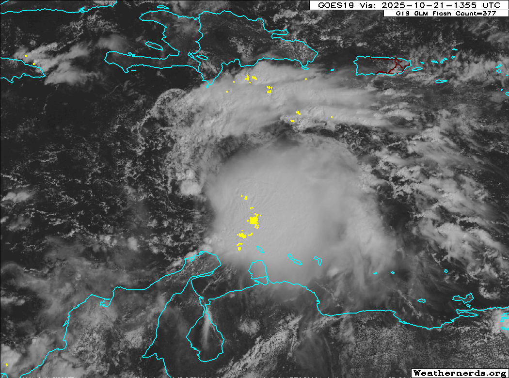
Wow, am I seeing this right? LLC appears to be at 14.4N and 72.6W. Recon is gonna have to turn on the afterburners and head further west if they're going to find an LLC. Models will continue to struggle with this until a better vertically aligned column is established. I'm not sure I see that happening until early tomorrow morning at the earliest (but more likely not until late tomorrow).
0 likes
Andy D
(For official information, please refer to the NHC and NWS products.)
(For official information, please refer to the NHC and NWS products.)
-
AutoPenalti
- Category 5

- Posts: 4091
- Age: 29
- Joined: Mon Aug 17, 2015 4:16 pm
- Location: Ft. Lauderdale, Florida
Re: NATL: MELISSA - Tropical Storm - Discussion
Unless that LLC dissipates and a new one forms under the MLC, this may go further west than what models have it now… it’s still under low level flow.
1 likes
The posts in this forum are NOT official forecasts and should not be used as such. They are just the opinion of the poster and may or may not be backed by sound meteorological data. They are NOT endorsed by any professional institution or STORM2K. For official information, please refer to products from the NHC and NWS.
Model Runs Cheat Sheet:
GFS (5:30 AM/PM, 11:30 AM/PM)
HWRF, GFDL, UKMET, NAVGEM (6:30-8:00 AM/PM, 12:30-2:00 AM/PM)
ECMWF (1:45 AM/PM)
TCVN is a weighted averaged
-
MEANINGLESS_NUMBERS
- Category 2
- Posts: 503
- Joined: Mon Nov 02, 2020 1:43 pm
Re: NATL: MELISSA - Tropical Storm - Discussion
This may be the worst humanitarian disaster of the year. Not a huge wind event but some of these rainfall totals will devastate Haiti.
1 likes
Emily '87, Felix '95, Gert '99, Fabian '03, Humberto '19, Paulette '20, Teddy '20, Fiona '22, Lee '23, Ernesto '24, Humberto/Imelda '25
-
SouthFLTropics

- Category 5
- Posts: 4258
- Age: 50
- Joined: Thu Aug 14, 2003 8:04 am
- Location: Port St. Lucie, Florida
Re: NATL: MELISSA - Tropical Storm - Discussion
This thing is hauling butt to the west. If the naked swirl doesn't die out, I can see it getting much further west than what the models are showing. Seems unlikely to slow down anytime soon.
0 likes
Fourth Generation Florida Native
Personal Storm History: David 79, Andrew 92, Erin 95, Floyd 99, Irene 99, Frances 04, Jeanne 04, Wilma 05, Matthew 16, Irma 17, Ian 22, Nicole 22, Milton 24
Personal Storm History: David 79, Andrew 92, Erin 95, Floyd 99, Irene 99, Frances 04, Jeanne 04, Wilma 05, Matthew 16, Irma 17, Ian 22, Nicole 22, Milton 24
-
storm_in_a_teacup

- Category 2
- Posts: 500
- Age: 33
- Joined: Wed Aug 16, 2017 5:01 pm
- Location: Huntsville, Alabama (originally from Houston)
- Contact:
Re: NATL: MELISSA - Tropical Storm - Discussion
chaser1 wrote:Kazmit wrote:I’m not sure who took it upon themselves to edit the 2025 season Wikipedia to their liking, but this is rather ominous.
https://i.ibb.co/6RddJpvp/IMG-5447.png
That's funny - The new "Wiki forecast". Hey, props to reaching "Olga" though. I just love that name for a tropical cyclone.
For me, Melissa is ironic because the main human character of my hurricane stories and comics is called Melissa, and she has two hurricanes that follow her around and drive her nuts. So this means at some point, Melissa needs to meet Melissa
(AnnularCane was of course the one who pointed out this otherwise obvious thing to me
2 likes
I know I can't straddle the atmosphere...just a tiny storm in your teacup, girl.
-
Blown Away

- S2K Supporter

- Posts: 10253
- Joined: Wed May 26, 2004 6:17 am
Re: NATL: MELISSA - Tropical Storm - Discussion
INIT 21/1500Z 14.3N 71.7W 45 KT 50 MPH
12H 22/0000Z 14.4N 72.8W 50 KT 60 MPH
24H 22/1200Z 14.8N 73.5W 55 KT 65 MPH
36H 23/0000Z 15.3N 74.2W 60 KT 70 MPH
48H 23/1200Z 15.7N 74.5W 60 KT 70 MPH
60H 24/0000Z 16.1N 74.6W 60 KT 70 MPH
72H 24/1200Z 16.5N 74.5W 60 KT 70 MPH
96H 25/1200Z 16.9N 74.5W 65 KT 75 MPH
120H 26/1200Z 17.2N 74.9W 70 KT 80 MPH
If the exposed LLC racing W continues to be Melissa and doesn't reform, then it will reach the predicted 24 hour longitude of 73.5 very soon, per the 11am NHC update.
2 likes
Hurricane Eye Experience: David 79, Irene 99, Frances 04, Jeanne 04, Wilma 05… Hurricane Brush Experience: Andrew 92, Erin 95, Floyd 99, Matthew 16, Irma 17, Ian 22, Nicole 22…
-
Iceresistance

- Category 5
- Posts: 9604
- Age: 22
- Joined: Sat Oct 10, 2020 9:45 am
- Location: Tecumseh, OK/Norman, OK
Re: NATL: MELISSA - Tropical Storm - Discussion
I seriously do not like where Melissa is at and where it's going, Melissa has the potential to be an extremely powerful hurricane if it can manage to get the inner core going with the shear relaxing. Melissa is heading for the very high Ocean Heat Content
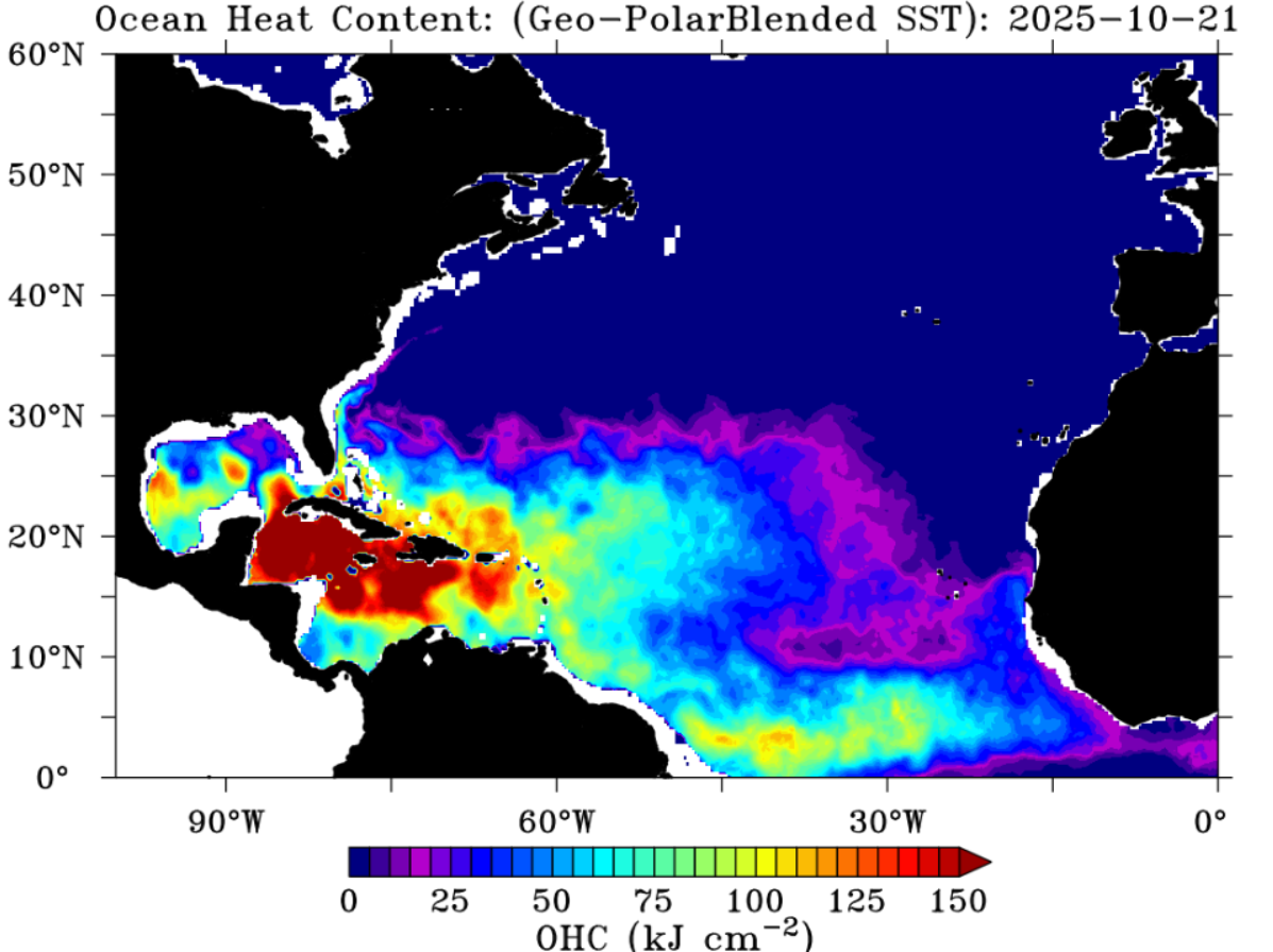
https://s12.gifyu.com/images/b39KN.png
https://s12.gifyu.com/images/b39KN.png
2 likes
Bill 2015 & Beta 2020
Winter 2020-2021
All observations are in Tecumseh, OK unless otherwise noted.
Winter posts are focused mainly for Oklahoma & Texas.
Take any of my forecasts with a grain of salt, refer to the NWS, SPC, and NHC for official information
Never say Never with weather! Because ANYTHING is possible!
Winter 2020-2021
All observations are in Tecumseh, OK unless otherwise noted.
Winter posts are focused mainly for Oklahoma & Texas.
Take any of my forecasts with a grain of salt, refer to the NWS, SPC, and NHC for official information
Never say Never with weather! Because ANYTHING is possible!


Re: NATL: MELISSA - Tropical Storm - Discussion
New center forming under convection if trends persist. If so, GFS takes a win,Haiti a loss. Sloppy C1-C2 there still could be devastating.
0 likes
-
AnnularCane

- S2K Supporter
- Posts: 2964
- Joined: Thu Jun 08, 2006 9:18 am
- Location: Wytheville, VA
Re: NATL: MELISSA - Tropical Storm - Discussion
chaser1 wrote:Kazmit wrote:I’m not sure who took it upon themselves to edit the 2025 season Wikipedia to their liking, but this is rather ominous.
https://i.ibb.co/6RddJpvp/IMG-5447.png
That's funny - The new "Wiki forecast". Hey, props to reaching "Olga" though. I just love that name for a tropical cyclone.
I wouldn't mind an end-of-season Olga.
2 likes
"But it never rained rain. It never snowed snow. And it never blew just wind. It rained things like soup and juice. It snowed mashed potatoes and green peas. And sometimes the wind blew in storms of hamburgers." -- Judi Barrett, Cloudy with a Chance of Meatballs

Re: NATL: MELISSA - Tropical Storm - Discussion
AnnularCane wrote:chaser1 wrote:Kazmit wrote:I’m not sure who took it upon themselves to edit the 2025 season Wikipedia to their liking, but this is rather ominous.
https://i.ibb.co/6RddJpvp/IMG-5447.png
That's funny - The new "Wiki forecast". Hey, props to reaching "Olga" though. I just love that name for a tropical cyclone.
I wouldn't mind an end-of-season Olga.
This naming list has ended at Olga quite a few times so it would be fitting.
2 likes
Re: NATL: MELISSA - Tropical Storm - Discussion
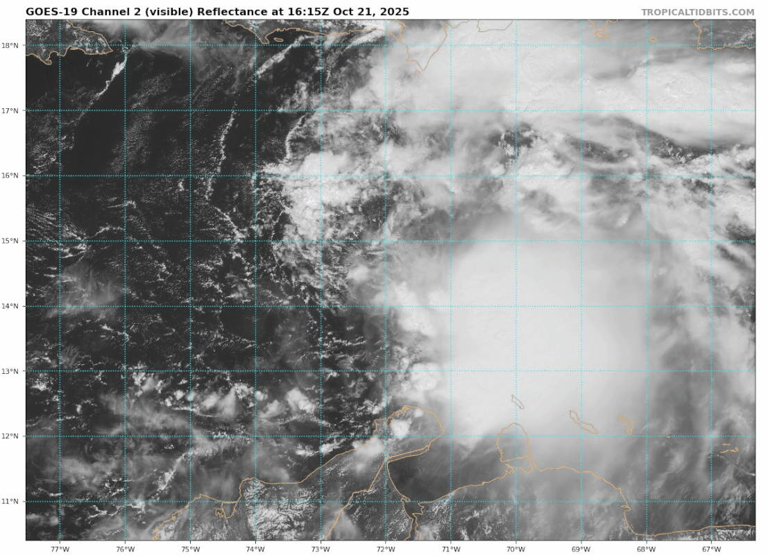
Blown Away wrote:[url]https://i.postimg.cc/NMSjBB4p/goes19-vis-13-L-202510211615-1.gif [/url]INIT 21/1500Z 14.3N 71.7W 45 KT 50 MPH
12H 22/0000Z 14.4N 72.8W 50 KT 60 MPH
24H 22/1200Z 14.8N 73.5W 55 KT 65 MPH
36H 23/0000Z 15.3N 74.2W 60 KT 70 MPH
48H 23/1200Z 15.7N 74.5W 60 KT 70 MPH
60H 24/0000Z 16.1N 74.6W 60 KT 70 MPH
72H 24/1200Z 16.5N 74.5W 60 KT 70 MPH
96H 25/1200Z 16.9N 74.5W 65 KT 75 MPH
120H 26/1200Z 17.2N 74.9W 70 KT 80 MPH
If the exposed LLC racing W continues to be Melissa and doesn't reform, then it will reach the predicted 24 hour longitude of 73.5 very soon, per the 11am NHC update.
That means it would be tracking closely to the Euro, UKMET, CMC, and JMA vs the further east GFS/Icon.
2 likes
Personal Forecast Disclaimer:
The posts in this forum are NOT official forecasts and should not be used as such. They are just the opinion of the poster and may or may not be backed by sound meteorological data. They are NOT endorsed by any professional institution or storm2k.org. For official information, please refer to the NHC and NWS products.
The posts in this forum are NOT official forecasts and should not be used as such. They are just the opinion of the poster and may or may not be backed by sound meteorological data. They are NOT endorsed by any professional institution or storm2k.org. For official information, please refer to the NHC and NWS products.
Who is online
Users browsing this forum: No registered users and 80 guests