NATL: MELISSA - Models

Current storms and invests:

Moderators: hurricanetrack, S2k Moderators


The posts in this forum are NOT official forecasts and should not be used as such. They are just the opinion of the poster and may or may not be backed by sound meteorological data. They are NOT endorsed by any professional institution or STORM2K. For official information, please refer to products from the National Hurricane Center and National Weather Service.

Help Support Storm2K
Message
Author
LarryWx
S2K Supporter
S2K Supporter
Posts: 6807
Joined: Sun Sep 07, 2003 2:04 pm
Location: GA

Re: NATL: MELISSA - Models

#141 Postby LarryWx » Tue Oct 21, 2025 11:55 am

Weathertracker96 wrote:
wzrgirl1 wrote:
Weathertracker96 wrote:The 12z CMC is surely interesting.


Hi, you can’t make a statement like that and not post the graphic lol


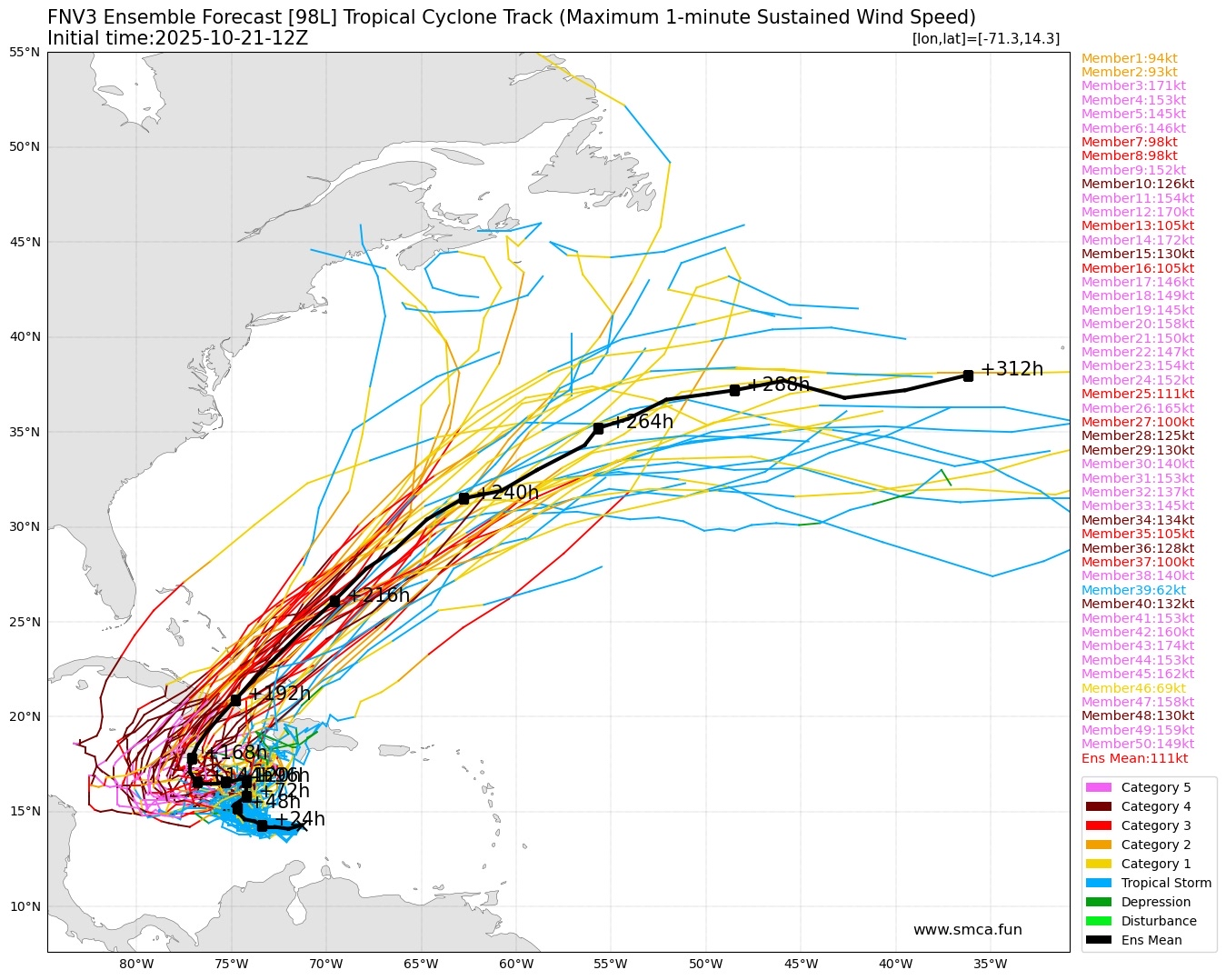
My apologizes lol. I still get stuck on how to post pictures on here. But the CMC has the system going more west and NE through central Cuba. But looking at the 12z GEFS, the ensembles seem more spread out than before. Hopefully recon will clear all this up.


The last 4 CMC runs have been pretty similar.
0 likes   
Personal Forecast Disclaimer:
The posts in this forum are NOT official forecasts and should not be used as such. They are just the opinion of the poster and may or may not be backed by sound meteorological data. They are NOT endorsed by any professional institution or storm2k.org. For official information, please refer to the NHC and NWS products.

Fancy1002
Category 1
Category 1
Posts: 261
Joined: Sun Dec 25, 2022 3:47 pm

Re: NATL: MELISSA - Models

#142 Postby Fancy1002 » Tue Oct 21, 2025 11:57 am

I guess the GFS wants another Caribbean storm after Melissa.
0 likes   

LarryWx
S2K Supporter
S2K Supporter
Posts: 6807
Joined: Sun Sep 07, 2003 2:04 pm
Location: GA

Re: NATL: MELISSA - Models

#143 Postby LarryWx » Tue Oct 21, 2025 12:00 pm

12Z UKMET: initialization of 14.7N, 70.8W is a bit NE of the actual NHC 12Z location. For the most part it’s sticking to its guns although its most N point is over a degree further N (16.6N vs 15.3N on 0Z). It loses TC status once approaching the Nicaragua/Honduras border:

TROPICAL STORM MELISSA ANALYSED POSITION : 14.7N 70.8W

ATCF IDENTIFIER : AL132025

LEAD CENTRAL MAXIMUM WIND
VERIFYING TIME TIME POSITION PRESSURE (MB) SPEED (KNOTS)
-------------- ---- -------- ------------- -------------
1200UTC 21.10.2025 0 14.7N 70.8W 1007 36
0000UTC 22.10.2025 12 14.7N 73.1W 1005 33
1200UTC 22.10.2025 24 15.0N 74.3W 1005 36
0000UTC 23.10.2025 36 15.5N 75.0W 1004 35
1200UTC 23.10.2025 48 16.1N 76.4W 1005 35
0000UTC 24.10.2025 60 16.4N 76.4W 1005 27
1200UTC 24.10.2025 72 16.6N 76.7W 1005 30
0000UTC 25.10.2025 84 16.4N 78.0W 1005 27
1200UTC 25.10.2025 96 15.7N 79.7W 1006 25
0000UTC 26.10.2025 108 15.1N 81.5W 1005 23
1200UTC 26.10.2025 120 15.0N 82.8W 1005 24
0000UTC 27.10.2025 132 15.5N 84.0W 1006 22
1200UTC 27.10.2025 144 CEASED TRACKING
0 likes   
Personal Forecast Disclaimer:
The posts in this forum are NOT official forecasts and should not be used as such. They are just the opinion of the poster and may or may not be backed by sound meteorological data. They are NOT endorsed by any professional institution or storm2k.org. For official information, please refer to the NHC and NWS products.

User avatar
ronjon
Category 5
Category 5
Posts: 4871
Joined: Fri Aug 19, 2005 5:17 pm
Location: Hernando Beach, FL

Re: NATL: MELISSA - Models

#144 Postby ronjon » Tue Oct 21, 2025 12:03 pm

12z GFS has Melissa down to 999 mb by 8 pm tonight and 989 mb by 2 pm tomorrow. Seems unlikely.
1 likes   

User avatar
chaser1
S2K Supporter
S2K Supporter
Posts: 5686
Age: 64
Joined: Sat Oct 15, 2005 5:59 pm
Location: Longwood, Fl

Re: NATL: MELISSA - Models

#145 Postby chaser1 » Tue Oct 21, 2025 12:18 pm

ronjon wrote:12z GFS has Melissa down to 999 mb by 8 pm tonight and 989 mb by 2 pm tomorrow. Seems unlikely.


Agreed; Furthermore, I tend to agree with GCANE (perhaps from the Discussion thread) that we may well see Melissa's LLC further detached and tilted from it's MLC during the day. This appears quite evident on present visible satellite as the day has progressed thus far. The LLC seems to be advancing more quickly westward, likely a result of the continued strong UL wind shear. Recon will verify whether Melissa is already near 1000 mb or not but I think that the GFS short term intensity forecast is suspect which would seem to favor subsequent ensemble forecasts later today/tonight to trend further west and northwest. I'm guessing we'll see tonight's GFS 0Z forecast to significantly change and at minimum shift westward.
0 likes   
Andy D

(For official information, please refer to the NHC and NWS products.)

User avatar
Woofde
Category 2
Category 2
Posts: 540
Joined: Tue Jul 06, 2021 11:33 am

Re: RE: Re: NATL: MELISSA - Models

#146 Postby Woofde » Tue Oct 21, 2025 12:54 pm

chaser1 wrote:
ronjon wrote:12z GFS has Melissa down to 999 mb by 8 pm tonight and 989 mb by 2 pm tomorrow. Seems unlikely.


Agreed; Furthermore, I tend to agree with GCANE (perhaps from the Discussion thread) that we may well see Melissa's LLC further detached and tilted from it's MLC during the day. This appears quite evident on present visible satellite as the day has progressed thus far. The LLC seems to be advancing more quickly westward, likely a result of the continued strong UL wind shear. Recon will verify whether Melissa is already near 1000 mb or not but I think that the GFS short term intensity forecast is suspect which would seem to favor subsequent ensemble forecasts later today/tonight to trend further west and northwest. I'm guessing we'll see tonight's GFS 0Z forecast to significantly change and at minimum shift westward.
Yeah I agree. That LLC is moving right out from underneath the system. We see this quite often with sheared systems. When the convection significantly slows down that'll be the sign it's left the area of high shear and it can begin to actually build a structure.

The GFS is overdoing short term intensification as usual. Odds of missing the weakness it shows are high.
1 likes   

User avatar
chaser1
S2K Supporter
S2K Supporter
Posts: 5686
Age: 64
Joined: Sat Oct 15, 2005 5:59 pm
Location: Longwood, Fl

Re: RE: Re: NATL: MELISSA - Models

#147 Postby chaser1 » Tue Oct 21, 2025 1:23 pm

Woofde wrote:
chaser1 wrote:
ronjon wrote:12z GFS has Melissa down to 999 mb by 8 pm tonight and 989 mb by 2 pm tomorrow. Seems unlikely.


Agreed; Furthermore, I tend to agree with GCANE (perhaps from the Discussion thread) that we may well see Melissa's LLC further detached and tilted from it's MLC during the day. This appears quite evident on present visible satellite as the day has progressed thus far. The LLC seems to be advancing more quickly westward, likely a result of the continued strong UL wind shear. Recon will verify whether Melissa is already near 1000 mb or not but I think that the GFS short term intensity forecast is suspect which would seem to favor subsequent ensemble forecasts later today/tonight to trend further west and northwest. I'm guessing we'll see tonight's GFS 0Z forecast to significantly change and at minimum shift westward.
Yeah I agree. That LLC is moving right out from underneath the system. We see this quite often with sheared systems. When the convection significantly slows down that'll be the sign it's left the area of high shear and it can begin to actually build a structure.

The GFS is overdoing short term intensification as usual. Odds of missing the weakness it shows are high.


I'm still torn on whether Melissa will miss this first weakness but I totally agree with you that its present motion and vertical structure would suggest a higher chance of missing it. If/when that occurs roughly around Thursday night (by the time a 2nd impulse drops into this first trough), then I have to think Melissa's future track will become far clearer from that point forward.
0 likes   
Andy D

(For official information, please refer to the NHC and NWS products.)

Pelicane
Tropical Storm
Tropical Storm
Posts: 179
Joined: Tue Sep 13, 2022 1:52 pm
Location: Lafayette, Louisiana

Re: NATL: MELISSA - Models

#148 Postby Pelicane » Tue Oct 21, 2025 1:45 pm

Euro takes this right over Jamaica as a very powerful hurricane, then shoots it NE.
0 likes   

User avatar
Iceresistance
Category 5
Category 5
Posts: 9317
Age: 22
Joined: Sat Oct 10, 2020 9:45 am
Location: Tecumseh, OK/Norman, OK

Re: NATL: MELISSA - Models

#149 Postby Iceresistance » Tue Oct 21, 2025 2:42 pm

I'm not sure if anyone has posted this, but this is insanity
29 members go for Category 5 intensity, and one of them peaks at 174 knots :eek:
Image
https://s12.gifyu.com/images/b39Ku.png
6 likes   
Bill 2015 & Beta 2020

Winter 2020-2021 :cold:

All observations are in Tecumseh, OK unless otherwise noted.

Winter posts are focused mainly for Oklahoma & Texas.

Take any of my forecasts with a grain of salt, refer to the NWS, SPC, and NHC for official information

Never say Never with weather! Because ANYTHING is possible!

Stormlover70
Tropical Storm
Tropical Storm
Posts: 193
Age: 55
Joined: Fri Jun 21, 2024 5:31 am
Location: New port richey

Re: NATL: MELISSA - Models

#150 Postby Stormlover70 » Tue Oct 21, 2025 2:43 pm

Iceresistance wrote:I'm not sure if anyone has posted this, but this is insanity
29 members go for Category 5 intensity, and one of them peaks at 174 knots :eek:
https://s12.gifyu.com/images/b39Ku.png
conus seems safe at this point
1 likes   

User avatar
sasha_B
Tropical Storm
Tropical Storm
Posts: 203
Age: 24
Joined: Sun Jun 30, 2024 4:32 pm
Location: Charleston, SC

Re: NATL: MELISSA - Models

#151 Postby sasha_B » Tue Oct 21, 2025 2:58 pm

Iceresistance wrote:I'm not sure if anyone has posted this, but this is insanity
29 members go for Category 5 intensity, and one of them peaks at 174 knots :eek:
https://s12.gifyu.com/images/b39Ku.png


Do you know what the pressure minimum is for that 174-kt member? The deepest low that I could spot was 890 hPa, but I might've missed one. 174/890 isn't quite the 182/878 member that the FNV ensemble gave us a couple days ago :lol: but is still impressively extreme. The more striking thing about today's 12z is the sheer proportion of member lows that reach MH/Cat 5/sub-900. When the mean wind maximum is near Category 4 & only one member shows anything less than a solid hurricane, that's about as aggressive an ensemble spread as you'll find for a system this early in its lifecycle.
Thankfully this particular ensemble remains an outlier with regard to its bullishness on Melissa's potential intensity....and it's hard to put any stock in hypothetical Wilma/Patricia-type solutions when the storm - at least for the moment - seems to be struggling to organise much at all.
1 likes   

User avatar
Iceresistance
Category 5
Category 5
Posts: 9317
Age: 22
Joined: Sat Oct 10, 2020 9:45 am
Location: Tecumseh, OK/Norman, OK

Re: NATL: MELISSA - Models

#152 Postby Iceresistance » Tue Oct 21, 2025 3:07 pm

sasha_B wrote:
Iceresistance wrote:I'm not sure if anyone has posted this, but this is insanity
29 members go for Category 5 intensity, and one of them peaks at 174 knots :eek:
https://s12.gifyu.com/images/b39Ku.png


Do you know what the pressure minimum is for that 174-kt member? The deepest low that I could spot was 890 hPa, but I might've missed one. 174/890 isn't quite the 182/878 member that the FNV ensemble gave us a couple days ago :lol: but is still impressively extreme. The more striking thing about today's 12z is the sheer proportion of member lows that reach MH/Cat 5/sub-900. When the mean wind maximum is near Category 4 & only one member shows anything less than a solid hurricane, that's about as aggressive an ensemble spread as you'll find for a system this early in its lifecycle.
Thankfully this particular ensemble remains an outlier with regard to its bullishness on Melissa's potential intensity....and it's hard to put any stock in hypothetical Wilma/Patricia-type solutions when the storm - at least for the moment - seems to be struggling to organise much at all.

Do you have an image of the 182/878 member run?
2 likes   
Bill 2015 & Beta 2020

Winter 2020-2021 :cold:

All observations are in Tecumseh, OK unless otherwise noted.

Winter posts are focused mainly for Oklahoma & Texas.

Take any of my forecasts with a grain of salt, refer to the NWS, SPC, and NHC for official information

Never say Never with weather! Because ANYTHING is possible!

Cachondo23
Tropical Storm
Tropical Storm
Posts: 131
Joined: Wed May 25, 2022 5:56 am

Re: NATL: MELISSA - Models

#153 Postby Cachondo23 » Tue Oct 21, 2025 3:14 pm

Pelicane wrote:Euro takes this right over Jamaica as a very powerful hurricane, then shoots it NE.

That could be catastrophic for Jamaica.
0 likes   

User avatar
Hayabusa
Category 5
Category 5
Posts: 4687
Joined: Sun Sep 16, 2018 1:05 pm

Re: NATL: MELISSA - Models

#154 Postby Hayabusa » Tue Oct 21, 2025 3:17 pm

Iceresistance wrote:I'm not sure if anyone has posted this, but this is insanity
29 members go for Category 5 intensity, and one of them peaks at 174 knots :eek:
https://s12.gifyu.com/images/b39Ku.png

What I noticed from the FNV3 over the Western Pacific, it tends to overhype the intensity but it's much weaker what happened in reality.
1 likes   
ヤンデレ女が寝取られるているのを見たい!!!
ECMWF ensemble NWPAC plots: https://ecmwfensnwpac.imgbb.com/
Multimodel NWPAC plots: https://multimodelnwpac.imgbb.com/
GFS Ensemble NWPAC plots (16 & 35 day forecast): https://gefsnwpac.imgbb.com/
Plots updated automatically

User avatar
sasha_B
Tropical Storm
Tropical Storm
Posts: 203
Age: 24
Joined: Sun Jun 30, 2024 4:32 pm
Location: Charleston, SC

Re: NATL: MELISSA - Models

#155 Postby sasha_B » Tue Oct 21, 2025 3:17 pm

Iceresistance wrote:Do you have an image of the 182/878 member run?


I don't want to upload a redundant/outdated image but it's post #39 in this thread - member 40 from the 19 October 6z FNV3 run at +198h.
2 likes   

User avatar
GCANE
S2K Supporter
S2K Supporter
Posts: 11809
Joined: Mon Oct 22, 2007 8:03 am

NATL: MELISSA - Tropical Storm - Discussion

#156 Postby GCANE » Tue Oct 21, 2025 3:30 pm

Chances going down quickly for a hit on Haiti.
Majority has a path to the West Carib

https://rammb-data.cira.colostate.edu/t ... 211800.png

https://rammb-data.cira.colostate.edu/t ... 210600.png
3 likes   

User avatar
Kazmit
Category 5
Category 5
Posts: 2210
Age: 22
Joined: Mon Jul 25, 2016 8:49 am
Location: Bermuda

Re: NATL: MELISSA - Tropical Storm - Discussion

#157 Postby Kazmit » Tue Oct 21, 2025 4:59 pm

GCANE wrote:Chances going down quickly for a hit on Haiti.
Majority has a path to the West Carib

https://rammb-data.cira.colostate.edu/t ... 211800.png

https://rammb-data.cira.colostate.edu/t ... 210600.png

And yet, the 18z GFS has a DR landfall. :lol:
1 likes   
Igor 2010, Sandy 2012, Fay 2014, Gonzalo 2014, Joaquin 2015, Nicole 2016, Humberto 2019, Imelda 2025

I am only a tropical weather enthusiast. My predictions are not official and may or may not be backed by sound meteorological data. For official information, please refer to the NHC and NWS products.

TomballEd
Category 5
Category 5
Posts: 1054
Age: 61
Joined: Wed Aug 16, 2023 4:52 pm
Location: Spring/Klein area, not Tomball

Re: NATL: MELISSA - Models

#158 Postby TomballEd » Tue Oct 21, 2025 5:19 pm

Cachondo23 wrote:
Pelicane wrote:Euro takes this right over Jamaica as a very powerful hurricane, then shoots it NE.

That could be catastrophic for Jamaica.


Beyond catastrophic. Image
1 likes   

User avatar
aspen
Category 5
Category 5
Posts: 8925
Joined: Sat Oct 12, 2019 7:10 pm
Location: Connecticut, USA

Re: NATL: MELISSA - Models

#159 Postby aspen » Tue Oct 21, 2025 5:23 pm

18z GFS has an even sharper turn to the NE this run, despite an initially weaker vortex. It really wants to kick this out of the Caribbean as fast as possible.
1 likes   
Irene '11 Sandy '12 Hermine '16 5/15/2018 Derecho Fay '20 Isaias '20 Elsa '21 Henri '21 Ida '21

I am only a meteorology enthusiast who knows a decent amount about tropical cyclones. Look to the professional mets, the NHC, or your local weather office for the best information.

MEANINGLESS_NUMBERS
Category 1
Category 1
Posts: 445
Joined: Mon Nov 02, 2020 1:43 pm

Re: NATL: MELISSA - Models

#160 Postby MEANINGLESS_NUMBERS » Tue Oct 21, 2025 5:32 pm

TomballEd wrote:
Cachondo23 wrote:
Pelicane wrote:Euro takes this right over Jamaica as a very powerful hurricane, then shoots it NE.

That could be catastrophic for Jamaica.


Beyond catastrophic. https://i.imgur.com/xUlMs4M.png


Isolated totals over 58 inches. That’s almost five feet of rain.
0 likes   
Emily '87, Felix '95, Gert '99, Fabian '03, Humberto '19, Paulette '20, Teddy '20, Fiona '22, Lee '23, Ernesto '24, Humberto/Imelda '25


Return to “Active Storms/Invests - Atlantic/EastPAC/CentralPAC/MED”

Who is online

Users browsing this forum: cycloneye, pepecool20 and 76 guests