NATL: MELISSA - Aftermath - Discussion: Josh Morgerman video of Melissa is up

Moderator: S2k Moderators

Message
Author
User avatar
Nimbus
Category 5
Category 5
Posts: 5444
Joined: Mon Jul 19, 2004 10:54 am

Re: NATL: MELISSA - Tropical Storm - Discussion

#301 Postby Nimbus » Thu Oct 23, 2025 6:25 am

Flwxguy86 wrote:I've personally got a real concern that the Gulf is being written off too prematurely, I know nobody is saying its completely off the table, but I think the real threat is there. It's still tilted and weak and will likely stay that way till Saturday night/Sunday morning. The models are all over the place. If that trough over Southern Georgia/Northern Florida is as strong as some models do show it in 120H, I would think from that position it only has 2 options, keep going west into central america or Northeast towards Florida. I just am not ready to buy into it crossing over into the atlantic yet. I can see why the models think that, but if we are gonna see rapid intensification around the cayman islands area..how does it not get into the gulf even if that means only clipping southern Florida. I am worried that this could be like michael where you walk up on sunday to the gulf suddenly being in play as the news media pretends it won't happen now because the models don't show it, but I think the pattern supports that. Obviously not 100% guarantee but a possibility that isn't being talked about enough, but I understand it, why scare the hell out of people a week out, but to pretend its almost a zero sum chance just erodes people's trust in the NHC and forecasting. I can see the talk of "weather modification" happening all over social media if that were to happen. I do know this is all dependent on it continuing WNW like it has so far and that through over southern georgia/Northern Florida where its forecasted now, just saying crazier things have happened..


There will be a second digging October trough, the only reason Melisa isn't being picked up now is that she isn't well organized enough to be steered. If the current trough had just been a little stronger and dug a little deeper into the Caribbean we might have had a naked swirl on the dry side of the front.

Neither Euro nor GFS have changed their guidance through the 6z today.
0 likes   

Weathertracker96
Tropical Storm
Tropical Storm
Posts: 150
Joined: Mon Oct 16, 2023 3:41 pm

Re: NATL: MELISSA - Tropical Storm - Discussion

#302 Postby Weathertracker96 » Thu Oct 23, 2025 6:42 am

Flwxguy86 wrote:I've personally got a real concern that the Gulf is being written off too prematurely, I know nobody is saying its completely off the table, but I think the real threat is there. It's still tilted and weak and will likely stay that way till Saturday night/Sunday morning. The models are all over the place. If that trough over Southern Georgia/Northern Florida is as strong as some models do show it in 120H, I would think from that position it only has 2 options, keep going west into central america or Northeast towards Florida. I just am not ready to buy into it crossing over into the atlantic yet. I can see why the models think that, but if we are gonna see rapid intensification around the cayman islands area..how does it not get into the gulf even if that means only clipping southern Florida. I am worried that this could be like michael where you walk up on sunday to the gulf suddenly being in play as the news media pretends it won't happen now because the models don't show it, but I think the pattern supports that. Obviously not 100% guarantee but a possibility that isn't being talked about enough, but I understand it, why scare the hell out of people a week out, but to pretend its almost a zero sum chance just erodes people's trust in the NHC and forecasting. I can see the talk of "weather modification" happening all over social media if that were to happen. I do know this is all dependent on it continuing WNW like it has so far and that through over southern georgia/Northern Florida where its forecasted now, just saying crazier things have happened..


Although it’s not likely now, I don’t see anything wrong with keeping an eye on it. Melissa is very unpredictable. I just the front is continuing to be sampled to help the models.
0 likes   

User avatar
Flwxguy86
Tropical Depression
Tropical Depression
Posts: 51
Age: 39
Joined: Sun Sep 15, 2024 11:06 am
Location: Oldsmar,FL

Re: NATL: MELISSA - Tropical Storm - Discussion

#303 Postby Flwxguy86 » Thu Oct 23, 2025 6:48 am

Nimbus wrote:
Flwxguy86 wrote:I've personally got a real concern that the Gulf is being written off too prematurely, I know nobody is saying its completely off the table, but I think the real threat is there. It's still tilted and weak and will likely stay that way till Saturday night/Sunday morning. The models are all over the place. If that trough over Southern Georgia/Northern Florida is as strong as some models do show it in 120H, I would think from that position it only has 2 options, keep going west into central america or Northeast towards Florida. I just am not ready to buy into it crossing over into the atlantic yet. I can see why the models think that, but if we are gonna see rapid intensification around the cayman islands area..how does it not get into the gulf even if that means only clipping southern Florida. I am worried that this could be like michael where you walk up on sunday to the gulf suddenly being in play as the news media pretends it won't happen now because the models don't show it, but I think the pattern supports that. Obviously not 100% guarantee but a possibility that isn't being talked about enough, but I understand it, why scare the hell out of people a week out, but to pretend its almost a zero sum chance just erodes people's trust in the NHC and forecasting. I can see the talk of "weather modification" happening all over social media if that were to happen. I do know this is all dependent on it continuing WNW like it has so far and that through over southern georgia/Northern Florida where its forecasted now, just saying crazier things have happened..


There will be a second digging October trough, the only reason Melisa isn't being picked up now is that she isn't well organized enough to be steered. If the current trough had just been a little stronger and dug a little deeper into the Caribbean we might have had a naked swirl on the dry side of the front.

Neither Euro nor GFS have changed their guidance through the 6z today.


That’s exactly my concern, by the time Melissa becomes vertically stacked and stronger, she should be near the Cayman Islands. If a second trough interacts with her there, it could significantly alter her track. Based on the current NHC 120-hour forecast, a path over eastern Cuba seems less likely physically, given the steering setup. I’ll be watching the 6Z guidance at 11AM, but either way, she’s likely to meander in that area for a few days before any next big steering influence kicks in. I just see it possibly taking longer to vertically stack then the models seem to be saying which maybe influences there current bias towards Hispaniola. it's too shallow in the atmosphere to feel any tug right now.
0 likes   

User avatar
GCANE
S2K Supporter
S2K Supporter
Posts: 12072
Joined: Mon Oct 22, 2007 8:03 am

Re: NATL: MELISSA - Tropical Storm - Discussion

#304 Postby GCANE » Thu Oct 23, 2025 7:03 am

For the convection that does fire, there is a massive amount of helicity.
Updraft is phenomenal.
Once the front starts to lift and shear relaxes, this will be epic.
3 likes   

User avatar
GCANE
S2K Supporter
S2K Supporter
Posts: 12072
Joined: Mon Oct 22, 2007 8:03 am

Re: NATL: MELISSA - Tropical Storm - Discussion

#305 Postby GCANE » Thu Oct 23, 2025 7:08 am

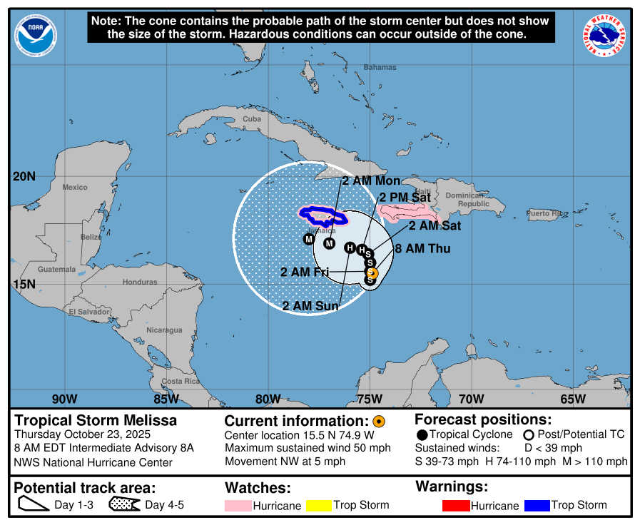
Looks like recon has it about 15.5N 74.9W, on track
0 likes   

User avatar
aspen
Category 5
Category 5
Posts: 9042
Joined: Sat Oct 12, 2019 7:10 pm
Location: Connecticut, USA

Re: NATL: MELISSA - Tropical Storm - Discussion

#306 Postby aspen » Thu Oct 23, 2025 7:24 am

Recon has found the LLC at approximately 15.6N/74.9W, right under a couple of hot towers. However, the overall circulation looks quite broad, so I wouldn’t be surprised to see the exact LLC jump around a little bit, which is what the hurricane models are forecasting.

This position is important to compare with the 06z hurricane model suite, even though their exact LLC positions fluctuate over the next 24-42 hours.
—The HWRF initializes very close to this recon fix, and by Friday afternoon, it’s still around 75W after jumping around to the east and west.
—The HMON is briefly far too strong and seems to be focusing on a center reformation near the MLC further SE of the recon fix. It initializes around 14.9N/74.2W but eventually gets to 17N/75W by 21z Friday, a similar position and time as the HWRF.
—The HAFS-A has a lot of trouble finding the center at first but eventually puts it at 15.5N/73.8W in 24 hours. It does not reach 75W until Saturday afternoon, nearly a full day after the HWRF/HMON.
—The HAFS-B struggles with the center placement even more than the HAFS-A, bouncing around until Friday evening at around 17N/74W. It then takes another full say to reach 75W.

What’s very interesting is how the HAFS-A/B, despite initializing the storm nearly a full degree further east than it is now, still have it going further west than both the HWRF and HMON. The A/B take it just south of Jamaica as a <920 Cat 5 undergoing EWRCs, while the HWRF/HMON are over or just north as Cat 3/4s.
3 likes   
Irene '11 Sandy '12 Hermine '16 5/15/2018 Derecho Fay '20 Isaias '20 Elsa '21 Henri '21 Ida '21

I am only a meteorology enthusiast who knows a decent amount about tropical cyclones. Look to the professional mets, the NHC, or your local weather office for the best information.

User avatar
GCANE
S2K Supporter
S2K Supporter
Posts: 12072
Joined: Mon Oct 22, 2007 8:03 am

Re: NATL: MELISSA - Tropical Storm - Discussion

#307 Postby GCANE » Thu Oct 23, 2025 7:34 am

About 50/50 now this goes deep into the West Carib

https://rammb-data.cira.colostate.edu/t ... 230600.png
0 likes   

User avatar
GCANE
S2K Supporter
S2K Supporter
Posts: 12072
Joined: Mon Oct 22, 2007 8:03 am

Re: NATL: MELISSA - Tropical Storm - Discussion

#308 Postby GCANE » Thu Oct 23, 2025 7:37 am

Hot tower going up with layering cirrus just NE of the CoC.
Getting close.

https://rammb-data.cira.colostate.edu/t ... 231210.jpg
0 likes   

hipshot
Category 2
Category 2
Posts: 618
Joined: Tue Jul 06, 2010 9:18 pm
Location: Dallas, Texas

Re: NATL: MELISSA - Tropical Storm - Discussion

#309 Postby hipshot » Thu Oct 23, 2025 7:56 am

Flwxguy86 wrote:
TomballEd wrote:Is the new blob to the NW of the main blob the LLC developing convection?

https://i.imgur.com/LuPg5cR.gif

I'm not great at analyzing these, but the circulation that I can see seems to still be to the south and east of the NW part your talking about. it's hard to tell from this view though. it's still not aligned and if that new blob is an LLC, I would believe the MLC and LLC are still pretty far apart.


What is that light colored, circular pattern with a hole in it at about 15.8N 76.6W in the far northwest section of the circulation? It
appears south of Jamaica.
0 likes   

User avatar
Teban54
Category 5
Category 5
Posts: 3787
Joined: Sat May 19, 2018 1:19 pm

Re: NATL: MELISSA - Tropical Storm - Discussion

#310 Postby Teban54 » Thu Oct 23, 2025 8:23 am

This really shows how erratic Melissa's center has been. The 5am ET NHC advisory had the center at 15.0N, but recon just found it at 15.5N, which wasn't expected until another 18 hours later.

However, as people noted in the model thread, this doesn't necessarily increase the chance of a northerly track later. HAFS A/B both have the center consolidating at 15.5N, but still go south of Jamaica.

Image
Last edited by Teban54 on Thu Oct 23, 2025 8:53 am, edited 1 time in total.
6 likes   

Pelicane
Tropical Storm
Tropical Storm
Posts: 190
Joined: Tue Sep 13, 2022 1:52 pm
Location: Lafayette, Louisiana

Re: NATL: MELISSA - Tropical Storm - Discussion

#311 Postby Pelicane » Thu Oct 23, 2025 8:35 am

Starting to look more shrimp-like.
1 likes   

aslan
Tropical Wave
Tropical Wave
Posts: 2
Joined: Sat Jun 24, 2017 11:04 am

Re: NATL: MELISSA - Tropical Storm - Discussion

#312 Postby aslan » Thu Oct 23, 2025 9:05 am

According to the last fix, center could be reformating farther south, around 15.1°N. This is also supported by visible imagery. The strong hot tower south to 15°N is probably pumping hard the center to the south. We will probable have to wait the end of the day to be sure where the center is, and so where Melissa is going, but still, a center farther south increase the odds for Melissa staying deep in the W Caribbean and going crazy.
4 likes   

User avatar
cheezyWXguy
Category 5
Category 5
Posts: 6242
Joined: Mon Feb 13, 2006 12:29 am
Location: Dallas, TX

Re: NATL: MELISSA - Tropical Storm - Discussion

#313 Postby cheezyWXguy » Thu Oct 23, 2025 9:09 am

Looks to me like shear has dropped off quite a bit since yesterday and this thing is getting stacked. Improved satellite appearance from even a few hours ago
3 likes   

User avatar
GCANE
S2K Supporter
S2K Supporter
Posts: 12072
Joined: Mon Oct 22, 2007 8:03 am

Re: NATL: MELISSA - Tropical Storm - Discussion

#314 Postby GCANE » Thu Oct 23, 2025 9:25 am

Very likely tapping into the EPAC moisture.
Appears to be a feeder band forming from Panama.
4 likes   

User avatar
kevin
Category 5
Category 5
Posts: 2878
Age: 27
Joined: Wed Aug 28, 2019 4:35 am

Re: NATL: MELISSA - Tropical Storm - Discussion

#315 Postby kevin » Thu Oct 23, 2025 9:27 am

Center moving SSW based on the second pass. Could of course be a wobble so let's wait for the third pass. But that would be an unexpected development.
Last edited by kevin on Thu Oct 23, 2025 9:46 am, edited 1 time in total.
2 likes   

User avatar
WaveBreaking
Category 2
Category 2
Posts: 709
Joined: Sun Jun 30, 2024 11:33 am
Location: US

Re: NATL: MELISSA - Tropical Storm - Discussion

#316 Postby WaveBreaking » Thu Oct 23, 2025 9:31 am

WaveBreaking wrote:All hurricane models show Melissa forming a new LLC under a blob of convection in about a day and then restrengthening btw, so I feel like even though it will probably look dead tomorrow, it'll most likely only be a pulse-down phase (think Gabrielle from earlier this year).


I stand corrected. Looks like it’s already trying to get going this morning.
3 likes   
I am NOT a professional meteorologist, so take all of my posts with a grain of salt. My opinions are mine and mine alone.

User avatar
cycloneye
Admin
Admin
Posts: 148594
Age: 69
Joined: Thu Oct 10, 2002 10:54 am
Location: San Juan, Puerto Rico

Re: NATL: MELISSA - Tropical Storm - Discussion

#317 Postby cycloneye » Thu Oct 23, 2025 9:31 am

kevin wrote:Center moving SSW based on the second pass. Could of course be a wobble so let's wait for the third pass. But that would be an unexpected development.


Image
3 likes   
Visit the Caribbean-Central America Weather Thread where you can find at first post web cams,radars
and observations from Caribbean basin members Click Here

User avatar
MGC
S2K Supporter
S2K Supporter
Posts: 5937
Joined: Sun Mar 23, 2003 9:05 pm
Location: Pass Christian MS, or what is left.

Re: NATL: MELISSA - Tropical Storm - Discussion

#318 Postby MGC » Thu Oct 23, 2025 9:45 am

Upper level flow will be shifting from the SW later today. This is what the GFS has been seeing the past few days. Should tilt or perhaps decouple the MCL to the NE from Melissa. I don't agree with a landfall on Hispaniola but it is possible the far western Tiburon Peninsula could be impacted. Still think Jamaica and Cuba are at greatest risk. Hopefully the cyclone landfalls in Jamaica and does not have the opportunity to develop into a major hurricane tracking south of the island before recurving......MGC
3 likes   

User avatar
Teban54
Category 5
Category 5
Posts: 3787
Joined: Sat May 19, 2018 1:19 pm

Re: NATL: MELISSA - Tropical Storm - Discussion

#319 Postby Teban54 » Thu Oct 23, 2025 10:35 am

From the 11am EDT discussion:
The end intensity could be conservative if Melissa ends up further
south of Jamaica with less land interaction, as suggested by the 00z
ECMWF and HAFS guidance.
3 likes   

User avatar
cycloneye
Admin
Admin
Posts: 148594
Age: 69
Joined: Thu Oct 10, 2002 10:54 am
Location: San Juan, Puerto Rico

Re: NATL: MELISSA - Tropical Storm - Discussion

#320 Postby cycloneye » Thu Oct 23, 2025 10:43 am

cycloneye wrote:
kevin wrote:Center moving SSW based on the second pass. Could of course be a wobble so let's wait for the third pass. But that would be an unexpected development.


https://i.imgur.com/ONWjUdr.png


It is doing the reorganization thing doing mini loops. Third pass was SSE.

Image
2 likes   
Visit the Caribbean-Central America Weather Thread where you can find at first post web cams,radars
and observations from Caribbean basin members Click Here


Return to “2025”

Who is online

Users browsing this forum: No registered users and 35 guests