

NATL: MELISSA - Aftermath - Discussion
Moderator: S2k Moderators
Re: NATL: MELISSA - Tropical Storm - Discussion
Significant improvement over the time of this loop. Assuming no more hiccups, a hurricane at the 11am EDT advisory seems like a given.
3 likes
TC naming lists: retirements and intensity
Most aggressive Advisory #1's in North Atlantic (cr. kevin for starting the list)
Most aggressive Advisory #1's in North Atlantic (cr. kevin for starting the list)
-
Hypercane_Kyle

- Category 5

- Posts: 3465
- Joined: Sat Mar 07, 2015 7:58 pm
- Location: Cape Canaveral, FL
Re: NATL: MELISSA - Tropical Storm - Discussion
Should be a hurricane later this morning.

4 likes
My posts are my own personal opinion, defer to the National Hurricane Center (NHC) and other NOAA products for decision making during hurricane season.
-
cycloneye

- Admin

- Posts: 149703
- Age: 69
- Joined: Thu Oct 10, 2002 10:54 am
- Location: San Juan, Puerto Rico
Re: NATL: MELISSA - Tropical Storm - Discussion
Big improvement this morning at TDR from last nights mission.

7 likes
Visit the Caribbean-Central America Weather Thread where you can find at first post web cams,radars
and observations from Caribbean basin members Click Here
and observations from Caribbean basin members Click Here
-
eastcoastFL

- Category 5
- Posts: 3996
- Age: 44
- Joined: Thu Apr 12, 2007 12:29 pm
- Location: Palm City, FL
Re: NATL: MELISSA - Tropical Storm - Discussion
A very rough couple of days and weeks ahead for our friends in the Caribbean. There haven't been any major track changes so it appears the CONUS will be spared.
4 likes
Personal Forecast Disclaimer:
The posts in this forum are NOT official forecast and should not be used as such. They are just the opinion of the poster and may or may not be backed by sound meteorological data. They are NOT endorsed by any professional institution or storm2k.org. For official information, please refer to the NHC and NWS products.
The posts in this forum are NOT official forecast and should not be used as such. They are just the opinion of the poster and may or may not be backed by sound meteorological data. They are NOT endorsed by any professional institution or storm2k.org. For official information, please refer to the NHC and NWS products.
-
cycloneye
- Admin
- Posts: 149703
- Age: 69
- Joined: Thu Oct 10, 2002 10:54 am
- Location: San Juan, Puerto Rico
Re: NATL: MELISSA - Tropical Storm - Discussion
The meso floater.

6 likes
Visit the Caribbean-Central America Weather Thread where you can find at first post web cams,radars
and observations from Caribbean basin members Click Here
and observations from Caribbean basin members Click Here


Re: NATL: MELISSA - Tropical Storm - Discussion
12z Best Track:
AL, 13, 2025102512, , BEST, 0, 163N, 750W, 60, 982, TS...
2 likes

Re: NATL: MELISSA - Tropical Storm - Discussion
abajan wrote:12z Best Track:AL, 13, 2025102512, , BEST, 0, 163N, 750W, 60, 982, TS...
Isn't that a more westerly track?
0 likes
Re: NATL: MELISSA - Tropical Storm - Discussion
hipshot wrote:abajan wrote:12z Best Track:AL, 13, 2025102512, , BEST, 0, 163N, 750W, 60, 982, TS...
Isn't that a more westerly track?
She’s hardly been moving as she was at 16.3N, 75.0W at 5AM EDT.
0 likes
Personal Forecast Disclaimer:
The posts in this forum are NOT official forecasts and should not be used as such. They are just the opinion of the poster and may or may not be backed by sound meteorological data. They are NOT endorsed by any professional institution or storm2k.org. For official information, please refer to the NHC and NWS products.
The posts in this forum are NOT official forecasts and should not be used as such. They are just the opinion of the poster and may or may not be backed by sound meteorological data. They are NOT endorsed by any professional institution or storm2k.org. For official information, please refer to the NHC and NWS products.
Re: NATL: MELISSA - Tropical Storm - Discussion
Looks to me like dual hot towers are now firing around 16.5N 75.0W, roughly where the center is.

1 likes
TC naming lists: retirements and intensity
Most aggressive Advisory #1's in North Atlantic (cr. kevin for starting the list)
Most aggressive Advisory #1's in North Atlantic (cr. kevin for starting the list)
-
Hurricane2022

- Category 5
- Posts: 2092
- Joined: Tue Aug 23, 2022 11:38 pm
- Location: Araçatuba, Brazil
Re: NATL: MELISSA - Tropical Storm - Discussion
Of course Melissa stopped from intensifying just when recon gets there
https://x.com/MikeAdcockWx/status/1982077885809914227
https://x.com/MikeAdcockWx/status/1982077885809914227
0 likes
Sorry for the bad English sometimes...!
For reliable and detailed information for any meteorological phenomenon, please consult the National Hurricane Center, Joint Typhoon Warning Center , or your local Meteo Center.
--------
ECCE OMNIA NOVA FACIAM (Ap 21,5).
For reliable and detailed information for any meteorological phenomenon, please consult the National Hurricane Center, Joint Typhoon Warning Center , or your local Meteo Center.
--------
ECCE OMNIA NOVA FACIAM (Ap 21,5).
-
cheezyWXguy

- Category 5
- Posts: 6282
- Joined: Mon Feb 13, 2006 12:29 am
- Location: Dallas, TX
Re: NATL: MELISSA - Tropical Storm - Discussion
The pressure gradient looks a lot tighter on the recon data this morning. Windfield still a little loose but much closer to being axisymmetric. Seems like a good bet that faster intensification will begin in the next few hours.
1 likes
-
eastcoastFL
- Category 5
- Posts: 3996
- Age: 44
- Joined: Thu Apr 12, 2007 12:29 pm
- Location: Palm City, FL
Re: NATL: MELISSA - Tropical Storm - Discussion
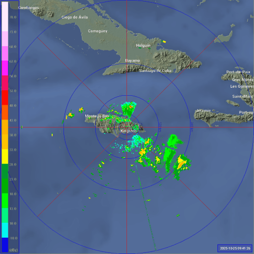
Looking at Jamaican radar right now there's some pretty clear wobbles due west.
0 likes
Personal Forecast Disclaimer:
The posts in this forum are NOT official forecast and should not be used as such. They are just the opinion of the poster and may or may not be backed by sound meteorological data. They are NOT endorsed by any professional institution or storm2k.org. For official information, please refer to the NHC and NWS products.
The posts in this forum are NOT official forecast and should not be used as such. They are just the opinion of the poster and may or may not be backed by sound meteorological data. They are NOT endorsed by any professional institution or storm2k.org. For official information, please refer to the NHC and NWS products.


Re: NATL: MELISSA - Tropical Storm - Discussion
Seems odd that the pressure's barely dropping per recon. Maybe early EWRC onset based on that radar data?
0 likes
-
cycloneye
- Admin
- Posts: 149703
- Age: 69
- Joined: Thu Oct 10, 2002 10:54 am
- Location: San Juan, Puerto Rico
Re: NATL: MELISSA - Tropical Storm - Discussion
Breaking: Looks like the AF plane has issues as it returns to Curacao and will not make a pass before the 11 AM advisory.

0 likes
Visit the Caribbean-Central America Weather Thread where you can find at first post web cams,radars
and observations from Caribbean basin members Click Here
and observations from Caribbean basin members Click Here

-
cheezyWXguy
- Category 5
- Posts: 6282
- Joined: Mon Feb 13, 2006 12:29 am
- Location: Dallas, TX
Re: NATL: MELISSA - Tropical Storm - Discussion
ThomasW wrote:Seems odd that the pressure's barely dropping per recon. Maybe early EWRC onset based on that radar data?
Since we haven’t really had an eyewall until recently, it’s probably more apt to call it continued core consolidation, but yeah this is probably the hold up at the moment. Maybe some dry air entrainment or remnant effects from the shear last night slowing the rate of strengthening. I think this will work itself out over the next few hours.
1 likes
-
Hypercane_Kyle
- Category 5
- Posts: 3465
- Joined: Sat Mar 07, 2015 7:58 pm
- Location: Cape Canaveral, FL
Re: NATL: MELISSA - Tropical Storm - Discussion
Even if it's borderline I'd imagine the NHC will upgrade at this point for messaging... because it's clear within an hour or two of becoming one regardless.
0 likes
My posts are my own personal opinion, defer to the National Hurricane Center (NHC) and other NOAA products for decision making during hurricane season.
-
cycloneye
- Admin
- Posts: 149703
- Age: 69
- Joined: Thu Oct 10, 2002 10:54 am
- Location: San Juan, Puerto Rico
Re: NATL: MELISSA - Tropical Storm - Discussion
There will be a gap of a few hours without recon data until the next two missions get going late this afternoon and evening.
0 likes
Visit the Caribbean-Central America Weather Thread where you can find at first post web cams,radars
and observations from Caribbean basin members Click Here
and observations from Caribbean basin members Click Here
Who is online
Users browsing this forum: No registered users and 80 guests