NATL: MELISSA - Aftermath - Discussion
Moderator: S2k Moderators

Re: NATL: MELISSA - Hurricane - Discussion
Eye is starting to pop out on both visible and IR
2 likes
Igor 2010, Sandy 2012, Fay 2014, Gonzalo 2014, Joaquin 2015, Nicole 2016, Humberto 2019, Imelda 2025
I am only a tropical weather enthusiast. My predictions are not official and may or may not be backed by sound meteorological data. For official information, please refer to the NHC and NWS products.
I am only a tropical weather enthusiast. My predictions are not official and may or may not be backed by sound meteorological data. For official information, please refer to the NHC and NWS products.
-
TomballEd
- Category 5

- Posts: 1322
- Age: 62
- Joined: Wed Aug 16, 2023 4:52 pm
- Location: Spring/Klein area, not Tomball
Re: NATL: MELISSA - Hurricane - Discussion
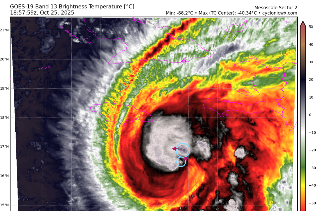
Teban54 wrote:Iceresistance wrote:I think Melissa has gotten the dual VHTs, the arrows are direction. The northern VHT is moving fast
https://s12.gifyu.com/images/b3n30.png
https://s12.gifyu.com/images/b3n30.png
Now it looks like there are even 3 hot towers:
https://i.imgur.com/UJ1rnpo.gif
Watching that loop out another 8 minutes I may or may not be seeing the first sign of the dimple that becomes the satellite visible eye.
0 likes
-
StormWeather

- Category 1

- Posts: 477
- Joined: Wed Jun 05, 2024 2:34 pm
Re: NATL: MELISSA - Hurricane - Discussion
Tbh this storm may be closing in on Category 2 intensity already, but we will see.
1 likes
Just an average cyclone tracker
The posts in this forum are NOT official forecasts and should not be used as such. They are just the opinion of the poster and may or may not be backed by sound meteorological data. They are NOT endorsed by any professional institution or storm2k.org. For official information, please refer to the NHC and NWS products
The posts in this forum are NOT official forecasts and should not be used as such. They are just the opinion of the poster and may or may not be backed by sound meteorological data. They are NOT endorsed by any professional institution or storm2k.org. For official information, please refer to the NHC and NWS products
-
CrazyC83
- Professional-Met

- Posts: 34316
- Joined: Tue Mar 07, 2006 11:57 pm
- Location: Deep South, for the first time!
Re: NATL: MELISSA - Hurricane - Discussion
I'd go with 80 kt for the advisory, although that is an uncertain estimate and Recon may find something much stronger. We may be playing catchup with special advisories tonight.
6 likes

Re: NATL: MELISSA - Hurricane - Discussion
edu2703 wrote:Pelicane wrote:
https://i.imgur.com/jUbxyTc.jpeg
Probably the worst place you could choose for a major airport in a hurricane-prone area.
Remember Sim City? That island is the perfect spot for an airport or power plant.
1 likes

Re: NATL: MELISSA - Hurricane - Discussion
StormWeather wrote:Tbh this storm may be closing in on Category 2 intensity already, but we will see.
I kinda doubt it. While the eyewall on radar is getting better, actual convection is still a little lacking. Likely a mid to upper end Cat 1, though. Cat 2 will likely be achieved once those rotating hot towers sustain themselves a little more.
3 likes
Irene '11 Sandy '12 Hermine '16 5/15/2018 Derecho Fay '20 Isaias '20 Elsa '21 Henri '21 Ida '21
I am only a meteorology enthusiast who knows a decent amount about tropical cyclones. Look to the professional mets, the NHC, or your local weather office for the best information.
I am only a meteorology enthusiast who knows a decent amount about tropical cyclones. Look to the professional mets, the NHC, or your local weather office for the best information.
-
USTropics
- Professional-Met
- Posts: 2741
- Joined: Sun Aug 12, 2007 3:45 am
- Location: Florida State University
Re: NATL: MELISSA - Hurricane - Discussion
Iceresistance wrote:I think Melissa has gotten the dual VHTs, the arrows are direction. The northern VHT is moving fast
https://s12.gifyu.com/images/b3n30.png
https://s12.gifyu.com/images/b3n30.png
Definitely some VHTs induced by the dry air interaction with the moist profile of Melissa's improving inner core:

We have some dry air entrainment as Melissa starts to expand her convective envelope. Meanwhile, we have this moist inner core developing which has high equivalent potential temperature (PT). This creates these localized boundaries where inflow basically hits a wall, and we get enhanced convergence when the dry air hits the moist inflow (environment PT decreases, parcel buoyancy increases), and rapid ascent of warm, moist air takes place (our VHTs).
Each point where the dry air "hits" the moist core can initiate a separate updraft. The red VHT is optimally positioned so it has the largest vertical ascent initially. As teal continues to rotate towards the north, it gets more of those direct localized enhanced convergence effects. This is the response to balance two things: (1) the asymmetric structure that Melissa currently exhibits and (2) as a means to mix out the dry air intrusion before it reaches the inner core and disrupts the eyewall formation cycle.

12 likes

-
Sciencerocks
- Category 5
- Posts: 10193
- Age: 40
- Joined: Thu Jul 06, 2017 1:51 am

-
HurricaneAndre2008

- Category 1
- Posts: 356
- Age: 28
- Joined: Wed Jul 31, 2019 9:51 pm
- Contact:
Re: NATL: MELISSA - Hurricane - Discussion
0 likes
Cindy(2005), Katrina(2005), Rita(2005), Erin(2007), Isaac(2012)
-
Iceresistance

- Category 5
- Posts: 9608
- Age: 22
- Joined: Sat Oct 10, 2020 9:45 am
- Location: Tecumseh, OK/Norman, OK
Re: NATL: MELISSA - Hurricane - Discussion
Is Melissa actually trying to close off a smaller eye??
0 likes
Bill 2015 & Beta 2020
Winter 2020-2021
All observations are in Tecumseh, OK unless otherwise noted.
Winter posts are focused mainly for Oklahoma & Texas.
Take any of my forecasts with a grain of salt, refer to the NWS, SPC, and NHC for official information
Never say Never with weather! Because ANYTHING is possible!
Winter 2020-2021
All observations are in Tecumseh, OK unless otherwise noted.
Winter posts are focused mainly for Oklahoma & Texas.
Take any of my forecasts with a grain of salt, refer to the NWS, SPC, and NHC for official information
Never say Never with weather! Because ANYTHING is possible!
-
WeatherBoy2000
- Category 1
- Posts: 463
- Joined: Mon Apr 10, 2023 9:29 am
Re: NATL: MELISSA - Hurricane - Discussion
zzzh wrote:NHC calls for a 140kt cat 5 peak!
If Melissa does achieve cat 5 intensity, 2025 would become the second Atlantic hurricane season on record to feature more than two cat 5s.
4 likes
Re: NATL: MELISSA - Hurricane - Discussion
WeatherBoy2000 wrote:zzzh wrote:NHC calls for a 140kt cat 5 peak!
If Melissa does achieve cat 5 intensity, 2025 would become the second Atlantic hurricane season on record to feature more than two cat 5s.
And it’ll be the season with the highest proportion of Cat 5s relative to NS total (23%), which is utterly ridiculous.
3 likes
Irene '11 Sandy '12 Hermine '16 5/15/2018 Derecho Fay '20 Isaias '20 Elsa '21 Henri '21 Ida '21
I am only a meteorology enthusiast who knows a decent amount about tropical cyclones. Look to the professional mets, the NHC, or your local weather office for the best information.
I am only a meteorology enthusiast who knows a decent amount about tropical cyclones. Look to the professional mets, the NHC, or your local weather office for the best information.

Re: NATL: MELISSA - Hurricane - Discussion
Sunset.

6 likes
TC naming lists: retirements and intensity
Most aggressive Advisory #1's in North Atlantic (cr. kevin for starting the list)
Most aggressive Advisory #1's in North Atlantic (cr. kevin for starting the list)
-
cycloneye

- Admin

- Posts: 149730
- Age: 69
- Joined: Thu Oct 10, 2002 10:54 am
- Location: San Juan, Puerto Rico
Re: NATL: MELISSA - Hurricane - Discussion
0 likes
Visit the Caribbean-Central America Weather Thread where you can find at first post web cams,radars
and observations from Caribbean basin members Click Here
and observations from Caribbean basin members Click Here
-
MGC

- S2K Supporter

- Posts: 5941
- Joined: Sun Mar 23, 2003 9:05 pm
- Location: Pass Christian MS, or what is left.
Re: NATL: MELISSA - Hurricane - Discussion
I'm afraid this is going to be catastrophic for Jamaica. Not too often a hurricane is forecast to make landfall as a Cat-5, sure hope the forecast is wrong. Melissa is in optimum conditions to intensify and I see little holding the cyclone back.....MGC
6 likes
-
USTropics
- Professional-Met
- Posts: 2741
- Joined: Sun Aug 12, 2007 3:45 am
- Location: Florida State University
Re: NATL: MELISSA - Hurricane - Discussion
This last VHT into convective updraft burst is likely going to establish the CDO and let the eyewall really build with height now:

3 likes

Re: NATL: MELISSA - Hurricane - Discussion
Really hard to say what recon will find at this point. Likely a strong Cat 1, as estimated on the 21z advisory, but what's more unclear at the moment - at least to my untrained eye - is the *rate* of intensification. We know from the MW imagery this morning that Melissa has the structure for very rapid intensification, and we saw an attempt at closing off an eyewall earlier this afternoon, but it doesn't appear to have been entirely successful. That said, the forecast discussion from the latest advisory suggests that the NHC doesn't think this delay will have much of an impact - if any - on the storm's overall intensification prospects.
2 likes
Who is online
Users browsing this forum: No registered users and 21 guests