NATL: MELISSA - Aftermath - Discussion
Moderator: S2k Moderators

Re: NATL: MELISSA - Hurricane - Discussion
So far 97kts FL winds and 970.8mb extrap, supports 85 and almost 90kts.
Last edited by Travorum on Sat Oct 25, 2025 5:56 pm, edited 1 time in total.
5 likes
-
Hurricane2022

- Category 5

- Posts: 2092
- Joined: Tue Aug 23, 2022 11:38 pm
- Location: Araçatuba, Brazil
Re: NATL: MELISSA - Hurricane - Discussion
970.9 extrap. 
0 likes
Sorry for the bad English sometimes...!
For reliable and detailed information for any meteorological phenomenon, please consult the National Hurricane Center, Joint Typhoon Warning Center , or your local Meteo Center.
--------
ECCE OMNIA NOVA FACIAM (Ap 21,5).
For reliable and detailed information for any meteorological phenomenon, please consult the National Hurricane Center, Joint Typhoon Warning Center , or your local Meteo Center.
--------
ECCE OMNIA NOVA FACIAM (Ap 21,5).
-
WaveBreaking

- Category 2

- Posts: 728
- Joined: Sun Jun 30, 2024 11:33 am
- Location: US
Re: NATL: MELISSA - Hurricane - Discussion
Last edited by WaveBreaking on Sat Oct 25, 2025 5:57 pm, edited 1 time in total.
1 likes
I am NOT a professional meteorologist, so take all of my posts with a grain of salt. My opinions are mine and mine alone.
-
CrazyC83
- Professional-Met

- Posts: 34316
- Joined: Tue Mar 07, 2006 11:57 pm
- Location: Deep South, for the first time!
Re: NATL: MELISSA - Hurricane - Discussion
WaveBreaking wrote:972mb/20kt in the eye and a peak FL wind of 97kt in the NW eyewall.
At least 85 kt so far.
0 likes

Re: NATL: MELISSA - Hurricane - Discussion
I’d go with 90kt/972mb. I think we may have a major by 11pm at this rate
2 likes
Irene '11 Sandy '12 Hermine '16 5/15/2018 Derecho Fay '20 Isaias '20 Elsa '21 Henri '21 Ida '21
I am only a meteorology enthusiast who knows a decent amount about tropical cyclones. Look to the professional mets, the NHC, or your local weather office for the best information.
I am only a meteorology enthusiast who knows a decent amount about tropical cyclones. Look to the professional mets, the NHC, or your local weather office for the best information.
-
Category5Kaiju

- Category 5
- Posts: 4346
- Joined: Thu Dec 24, 2020 12:45 pm
- Location: Seattle during the summer, Phoenix during the winter
Re: NATL: MELISSA - Hurricane - Discussion
Well, just looked at Twitter/X and saw that the legendary Josh Morgerman has made his decision to chase Melissa in Jamaica. Looks like things are about to get real!
3 likes
Unless explicitly stated, all information in my posts is based on my own opinions and observations. Tropical storms and hurricanes can be extremely dangerous. Refer to an accredited weather research agency or meteorologist if you need to make serious decisions regarding an approaching storm.
-
Hypercane_Kyle

- Category 5
- Posts: 3465
- Joined: Sat Mar 07, 2015 7:58 pm
- Location: Cape Canaveral, FL
Re: NATL: MELISSA - Hurricane - Discussion
Agree with 90 knots, potentially 95 knots pending what next few passes show
1 likes
My posts are my own personal opinion, defer to the National Hurricane Center (NHC) and other NOAA products for decision making during hurricane season.
-
Hurricane2022
- Category 5
- Posts: 2092
- Joined: Tue Aug 23, 2022 11:38 pm
- Location: Araçatuba, Brazil
Re: NATL: MELISSA - Hurricane - Discussion
BobHarlem wrote:Jamaica Radar Loop
https://i.postimg.cc/4NfCxt5H/Jamaica-Radar-Melissa-recent-1.gif
The eye seems to be contracting considerably. What a historic and catastrophic weekend for Jamaica.
0 likes
Sorry for the bad English sometimes...!
For reliable and detailed information for any meteorological phenomenon, please consult the National Hurricane Center, Joint Typhoon Warning Center , or your local Meteo Center.
--------
ECCE OMNIA NOVA FACIAM (Ap 21,5).
For reliable and detailed information for any meteorological phenomenon, please consult the National Hurricane Center, Joint Typhoon Warning Center , or your local Meteo Center.
--------
ECCE OMNIA NOVA FACIAM (Ap 21,5).

Re: NATL: MELISSA - Hurricane - Discussion
Travorum wrote:So far 97kts FL winds and 970.8mb extrap, supports 85/90kts.
The last recon flights that ended at 13z were measuring 983-985 mb. This is a minimum pressure drop of 1.2 mb/hr (maybe more depending on interpretation). Even though far from extreme, it's still impressive considering Melissa seemingly ingesting some dry air in the afternoon, and that the previous recon was still finding an open eyewall intermittently.
2 likes
TC naming lists: retirements and intensity
Most aggressive Advisory #1's in North Atlantic (cr. kevin for starting the list)
Most aggressive Advisory #1's in North Atlantic (cr. kevin for starting the list)
-
WaveBreaking
- Category 2
- Posts: 728
- Joined: Sun Jun 30, 2024 11:33 am
- Location: US
Re: NATL: MELISSA - Hurricane - Discussion
It looks like Melissa is now trying to fire an entire semicircle of new VHTs in the W eyewall.

Last edited by WaveBreaking on Sat Oct 25, 2025 6:04 pm, edited 1 time in total.
6 likes
I am NOT a professional meteorologist, so take all of my posts with a grain of salt. My opinions are mine and mine alone.
-
CrazyC83
- Professional-Met
- Posts: 34316
- Joined: Tue Mar 07, 2006 11:57 pm
- Location: Deep South, for the first time!
Re: NATL: MELISSA - Hurricane - Discussion
WaveBreaking wrote:It looks like Melissa is not trying to fire an entire semicircle of new VHTs in the W eyewall.
https://i.imgur.com/lmPb0bf.gif
If the eye can wrap around those cloud tops, look out.
3 likes
-
KirbyDude25

- Tropical Storm

- Posts: 162
- Age: 21
- Joined: Mon Sep 20, 2021 8:03 am
- Location: Westfield, New Jersey
Re: NATL: MELISSA - Hurricane - Discussion
WaveBreaking wrote:It looks like Melissa is not trying to fire an entire semicircle of new VHTs in the W eyewall.
https://i.imgur.com/lmPb0bf.gif
Did you mean to type "now"? Regardless, it actually took a bit for me to spot the VHT semicircle because the entire CDO is so cold. Definitely taking off now (though we'll have to wait until the next pass to see just how fast)
2 likes
New Jersey, Rutgers '27
Irene 2011 | Sandy 2012 | Fay 2020 | Isaias 2020 | Ida 2021
Irene 2011 | Sandy 2012 | Fay 2020 | Isaias 2020 | Ida 2021
-
WaveBreaking
- Category 2
- Posts: 728
- Joined: Sun Jun 30, 2024 11:33 am
- Location: US
Re: NATL: MELISSA - Hurricane - Discussion
KirbyDude25 wrote:WaveBreaking wrote:It looks like Melissa is not trying to fire an entire semicircle of new VHTs in the W eyewall.
https://i.imgur.com/lmPb0bf.gif
Did you mean to type "now"? Regardless, it actually took a bit for me to spot the VHT semicircle because the entire CDO is so cold. Definitely taking off now (though we'll have to wait until the next pass to see just how fast)
Yeah I meant to type now. Autocorrect got me.
0 likes
I am NOT a professional meteorologist, so take all of my posts with a grain of salt. My opinions are mine and mine alone.
-
Hurricane2022
- Category 5
- Posts: 2092
- Joined: Tue Aug 23, 2022 11:38 pm
- Location: Araçatuba, Brazil
Re: NATL: MELISSA - Hurricane - Discussion
0 likes
Sorry for the bad English sometimes...!
For reliable and detailed information for any meteorological phenomenon, please consult the National Hurricane Center, Joint Typhoon Warning Center , or your local Meteo Center.
--------
ECCE OMNIA NOVA FACIAM (Ap 21,5).
For reliable and detailed information for any meteorological phenomenon, please consult the National Hurricane Center, Joint Typhoon Warning Center , or your local Meteo Center.
--------
ECCE OMNIA NOVA FACIAM (Ap 21,5).
Re: NATL: MELISSA - Hurricane - Discussion
Don't forget right now the NOAA plane is flying around the 750 mbar level, not 700 so the reduction to surface is gonna be around .85 or so. Max wind they got was 97 kt so 80-85 kt surface.
4 likes

Re: NATL: MELISSA - Hurricane - Discussion
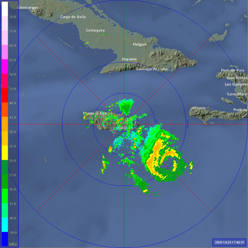
There does seem to be a moat on radar.
Watching this if it persists and waiting to see what recon reports.
Watching this if it persists and waiting to see what recon reports.
2 likes
-
HurricaneBelle

- S2K Supporter

- Posts: 1209
- Joined: Sun Aug 27, 2006 6:12 pm
- Location: Clearwater, FL
Re: NATL: MELISSA - Hurricane - Discussion
Category5Kaiju wrote:Well, just looked at Twitter/X and saw that the legendary Josh Morgerman has made his decision to chase Melissa in Jamaica. Looks like things are about to get real!
With the airport in the harbor, he's going to need a boat to get home.
0 likes
-
Blown Away

- S2K Supporter
- Posts: 10253
- Joined: Wed May 26, 2004 6:17 am
Re: NATL: MELISSA - Hurricane - Discussion
I’m concerned about Jamaica man! 

2 likes
Hurricane Eye Experience: David 79, Irene 99, Frances 04, Jeanne 04, Wilma 05… Hurricane Brush Experience: Andrew 92, Erin 95, Floyd 99, Matthew 16, Irma 17, Ian 22, Nicole 22…
Who is online
Users browsing this forum: No registered users and 62 guests