
NATL: MELISSA - Aftermath - Discussion
Moderator: S2k Moderators
-
Hurricane2022

- Category 5

- Posts: 2092
- Joined: Tue Aug 23, 2022 11:38 pm
- Location: Araçatuba, Brazil
Re: NATL: MELISSA - Hurricane - Discussion
Ok
8 likes
Sorry for the bad English sometimes...!
For reliable and detailed information for any meteorological phenomenon, please consult the National Hurricane Center, Joint Typhoon Warning Center , or your local Meteo Center.
--------
ECCE OMNIA NOVA FACIAM (Ap 21,5).
For reliable and detailed information for any meteorological phenomenon, please consult the National Hurricane Center, Joint Typhoon Warning Center , or your local Meteo Center.
--------
ECCE OMNIA NOVA FACIAM (Ap 21,5).
-
xtyphooncyclonex

- Category 5
- Posts: 3899
- Age: 24
- Joined: Sat Dec 08, 2012 9:07 am
- Location: Cebu City
- Contact:
Re: NATL: MELISSA - Hurricane - Discussion
Looks like we could see 100-105 knots in a couple minutes. Those cloud tops are ferocious. Coupled with the sheer amount of time and boiling hot waters, I don't know what the ceiling is at this point. I pray for the people of Jamaica
1 likes
REMINDER: My opinions that I, or any other NON Pro-Met in this forum, are unofficial. Please do not take my opinions as an official forecast and warning. I am NOT a meteorologist. Following my forecasts blindly may lead to false alarm, danger and risk if official forecasts from agencies are ignored.
-
InfernoFlameCat

- Category 5
- Posts: 2127
- Age: 23
- Joined: Mon Dec 14, 2020 10:52 am
- Location: Buford, GA
Re: NATL: MELISSA - Hurricane - Discussion
I have been lurking, but this is too WOW to not post about. Sheer awe. I predicted a 150 knot storm, but I thought I was being ridiculous. I don’t need to describe whats going on, we are all seeing it, but WOW
1 likes
I am by no means a professional. DO NOT look at my forecasts for official information or make decisions based on what I post.
Goal: to become a registered expert over tropical and subtropical cyclones.
Goal: to become a registered expert over tropical and subtropical cyclones.
-
Iceresistance

- Category 5
- Posts: 9607
- Age: 22
- Joined: Sat Oct 10, 2020 9:45 am
- Location: Tecumseh, OK/Norman, OK
Re: NATL: MELISSA - Hurricane - Discussion
9 likes
Bill 2015 & Beta 2020
Winter 2020-2021
All observations are in Tecumseh, OK unless otherwise noted.
Winter posts are focused mainly for Oklahoma & Texas.
Take any of my forecasts with a grain of salt, refer to the NWS, SPC, and NHC for official information
Never say Never with weather! Because ANYTHING is possible!
Winter 2020-2021
All observations are in Tecumseh, OK unless otherwise noted.
Winter posts are focused mainly for Oklahoma & Texas.
Take any of my forecasts with a grain of salt, refer to the NWS, SPC, and NHC for official information
Never say Never with weather! Because ANYTHING is possible!

Re: NATL: MELISSA - Hurricane - Discussion
crimi481 wrote:If it goes more south and west, could the next front miss lifting it out to sea?
Seems exceedingly doubtful given the almost-absolute constant of all models suggesting a hard right turn to the northeast, but I'm juuuust twitchy enough at the moment to keep checking in for any sign of a 'breakthrough' all the same. After all, any storm in that location is usually one I need to keep an eye on.
1 likes
Baton Rouge area cyclone dilettante, PSWAGGER* tropical weather & hydrology model developer
(* Pseudo-Scientific Wild-A** Guesses Generally Expressed Ridiculously)
The GFDL would've had all this figured out by now.
(* Pseudo-Scientific Wild-A** Guesses Generally Expressed Ridiculously)
The GFDL would've had all this figured out by now.


Re: NATL: MELISSA - Hurricane - Discussion
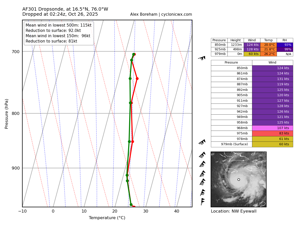
Raw T# is almost up to 7.0 and that's with ADT fixing the center firmly in the outskirts of the CDO. Obviously its going to take a while of continued structural improvement for wind speeds and the CI# to catch up but man is the structure good right now for the future.

ADVANCED DVORAK TECHNIQUE
ADT-Version 9.1
Tropical Cyclone Intensity Algorithm
----- Current Analysis -----
Date : 26 OCT 2025 Time : 021021 UTC
Lat : 16:39:15 N Lon : 75:46:27 W
CI# /Pressure/ Vmax
4.4 / 975.6mb/ 74.6kt
Final T# Adj T# Raw T#
4.4 4.4 6.9
Estimated radius of max. wind based on IR :<10 km
Center Temp : -23.9C Cloud Region Temp : -75.8C
Scene Type : PINHOLE EYE
4 likes
Re: NATL: MELISSA - Hurricane - Discussion
Yeah it’s officially a Category 3 hurricane now…it only gets worse from here
3 likes
-
CrazyC83
- Professional-Met

- Posts: 34316
- Joined: Tue Mar 07, 2006 11:57 pm
- Location: Deep South, for the first time!
Re: NATL: MELISSA - Hurricane - Discussion
If that CDG can completely wrap around the eye, then it's off to the races.
5 likes
-
Iceresistance
- Category 5
- Posts: 9607
- Age: 22
- Joined: Sat Oct 10, 2020 9:45 am
- Location: Tecumseh, OK/Norman, OK
Re: NATL: MELISSA - Hurricane - Discussion
I don't think I remember seeing the NHC explicitly mention "Seek Shelter Now", that is actually very frightening
Key Messages:
1. Jamaica: [b]Seek shelter now. A multi-day period of damaging
winds and heavy rainfall have begun and will cause catastrophic and
life-threatening flash flooding and numerous landslides. Extensive
infrastructural damage, long-duration power and communication
outages, and isolation of communities are expected.
Life-threatening storm surge is likely along portions of the
southern coast early next week.[/b]
Last edited by Iceresistance on Sat Oct 25, 2025 9:56 pm, edited 1 time in total.
12 likes
Bill 2015 & Beta 2020
Winter 2020-2021
All observations are in Tecumseh, OK unless otherwise noted.
Winter posts are focused mainly for Oklahoma & Texas.
Take any of my forecasts with a grain of salt, refer to the NWS, SPC, and NHC for official information
Never say Never with weather! Because ANYTHING is possible!
Winter 2020-2021
All observations are in Tecumseh, OK unless otherwise noted.
Winter posts are focused mainly for Oklahoma & Texas.
Take any of my forecasts with a grain of salt, refer to the NWS, SPC, and NHC for official information
Never say Never with weather! Because ANYTHING is possible!
-
weeniepatrol

- Category 5
- Posts: 1345
- Joined: Sat Aug 22, 2020 5:30 pm
- Location: WA State

Re: NATL: MELISSA - Hurricane - Discussion
Iceresistance wrote:I don't think I remember seeing the NHC explicitly mention "Seek Shelter Now", that is actually very frighteningKey Messages:
1. Jamaica: Seek shelter now. A multi-day period of damaging
winds and heavy rainfall have begun and will cause catastrophic and
life-threatening flash flooding and numerous landslides. Extensive
infrastructural damage, long-duration power and communication
outages, and isolation of communities are expected.
Life-threatening storm surge is likely along portions of the
southern coast early next week.
The NHC realizes that this could be a potentially historic catastrophe for the island nation if many of these latest computer models are accurate. They, and many of us here, recognize that Jamaica, historically, for all intents and purposes, has never had to prepare for this type of weather scenario.
Last edited by 869MB on Sat Oct 25, 2025 10:07 pm, edited 1 time in total.
5 likes
-
Blown Away

- S2K Supporter

- Posts: 10253
- Joined: Wed May 26, 2004 6:17 am
Re: NATL: MELISSA - Hurricane - Discussion
weeniepatrol wrote:13/5/4.
17/7/4 for me.
Hard to predict 4/5 total hurricanes are Major…

Last edited by Blown Away on Sat Oct 25, 2025 10:07 pm, edited 1 time in total.
1 likes
Hurricane Eye Experience: David 79, Irene 99, Frances 04, Jeanne 04, Wilma 05… Hurricane Brush Experience: Andrew 92, Erin 95, Floyd 99, Matthew 16, Irma 17, Ian 22, Nicole 22…
-
ScottNAtlanta

- Category 5
- Posts: 2535
- Joined: Sat May 25, 2013 3:11 pm
- Location: Atlanta, GA
Re: NATL: MELISSA - Hurricane - Discussion
ACE points should really start accumulating now
4 likes
The posts in this forum are NOT official forecast and should not be used as such. They are just the opinion of the poster and may or may not be backed by sound meteorological data. They are NOT endorsed by any professional institution or storm2k.org. For official information, please refer to the NHC and NWS products.
-
ScottNAtlanta
- Category 5
- Posts: 2535
- Joined: Sat May 25, 2013 3:11 pm
- Location: Atlanta, GA
Re: NATL: MELISSA - Hurricane - Discussion
Eye is out

10 likes
The posts in this forum are NOT official forecast and should not be used as such. They are just the opinion of the poster and may or may not be backed by sound meteorological data. They are NOT endorsed by any professional institution or storm2k.org. For official information, please refer to the NHC and NWS products.

Re: NATL: MELISSA - Hurricane - Discussion

7 likes
TC naming lists: retirements and intensity
Most aggressive Advisory #1's in North Atlantic (cr. kevin for starting the list)
Most aggressive Advisory #1's in North Atlantic (cr. kevin for starting the list)
-
Blown Away
- S2K Supporter
- Posts: 10253
- Joined: Wed May 26, 2004 6:17 am
Re: NATL: MELISSA - Hurricane - Discussion
It seems if Melissa continues moving slightly S of W the trough will catch her farther E and the angle of the NE turn would be closer the E end of Jamaica…
0 likes
Hurricane Eye Experience: David 79, Irene 99, Frances 04, Jeanne 04, Wilma 05… Hurricane Brush Experience: Andrew 92, Erin 95, Floyd 99, Matthew 16, Irma 17, Ian 22, Nicole 22…

Re: NATL: MELISSA - Hurricane - Discussion
Raw ADT# just jumped to 7.5
Alas, the microwave adjustment is on, so final T# remains stuck at 4.4.
Alas, the microwave adjustment is on, so final T# remains stuck at 4.4.
3 likes
Re: NATL: MELISSA - Hurricane - Discussion
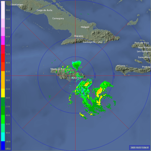
Long duration radar loop of Melissa (since eye was discernible on radar) until now.
3 likes
-
Blown Away
- S2K Supporter
- Posts: 10253
- Joined: Wed May 26, 2004 6:17 am
Re: NATL: MELISSA - Hurricane - Discussion
BobHarlem wrote:Long duration radar loop of Melissa (since eye was discernible on radar) until now.
https://i.postimg.cc/qvKw9sDy/Jamaica-Radar-Melissa-10.gif
Bob can you provide the radar link? Thanks..
1 likes
Hurricane Eye Experience: David 79, Irene 99, Frances 04, Jeanne 04, Wilma 05… Hurricane Brush Experience: Andrew 92, Erin 95, Floyd 99, Matthew 16, Irma 17, Ian 22, Nicole 22…
Who is online
Users browsing this forum: No registered users and 51 guests