NATL: MELISSA - Hurricane - Discussion
Moderators: hurricanetrack, S2k Moderators

The posts in this forum are NOT official forecasts and should not be used as such. They are just the opinion of the poster and may or may not be backed by sound meteorological data. They are NOT endorsed by any professional institution or STORM2K. For official information, please refer to products from the National Hurricane Center and National Weather Service.
Re: NATL: MELISSA - Hurricane - Discussion
Raw T# back up to 7.5, CDO at -76C and the eye temp up to its highest value so far of 15.7C. Looks like recon is arriving at the perfect time.
1 likes
Re: NATL: MELISSA - Hurricane - Discussion
It shouldn’t be too long before we get our first pass.
0 likes
- mrbagyo
- Category 5

- Posts: 3833
- Age: 33
- Joined: Thu Apr 12, 2012 9:18 am
- Location: 14.13N 120.98E
- Contact:
Re: NATL: MELISSA - Hurricane - Discussion
948.9 extrapolated
0 likes
The posts in this forum are NOT official forecast and should not be used as such. They are just the opinion of the poster and may or may not be backed by sound meteorological data. They are NOT endorsed by any professional institution or storm2k.org. For official information, please refer to RSMC, NHC and NWS products.
Re: NATL: MELISSA - Hurricane - Discussion
I’m guessing she’s somewhere around 940 mb and 125-130 kts.
Edit: 949 extrap
Edit: 949 extrap
0 likes
- eastcoastFL
- Category 5

- Posts: 3958
- Age: 43
- Joined: Thu Apr 12, 2007 12:29 pm
- Location: Palm City, FL
Re: NATL: MELISSA - Hurricane - Discussion
The wind field is still extremely small with hurricane force wines reaching out just 25 miles from center. The surge and rain is still going to be the biggest issue but at least the worst of the winds will be somewhat isolated.
0 likes
Personal Forecast Disclaimer:
The posts in this forum are NOT official forecast and should not be used as such. They are just the opinion of the poster and may or may not be backed by sound meteorological data. They are NOT endorsed by any professional institution or storm2k.org. For official information, please refer to the NHC and NWS products.
-
otowntiger
- Category 5

- Posts: 1932
- Joined: Tue Aug 31, 2004 7:06 pm
Re: NATL: MELISSA - Hurricane - Discussion
eastcoastFL wrote:The wind field is still extremely small with hurricane force wines reaching out just 25 miles from center. The surge and rain is still going to be the biggest issue but at least the worst of the winds will be somewhat isolated.
I was noticing that too. This is a very compact storm- similar to Andrew
2 likes
- TheDreamTraveler
- Category 2

- Posts: 644
- Joined: Sun Aug 22, 2010 3:10 am
- Location: PA
Re: NATL: MELISSA - Hurricane - Discussion
eastcoastFL wrote:The wind field is still extremely small with hurricane force wines reaching out just 25 miles from center. The surge and rain is still going to be the biggest issue but at least the worst of the winds will be somewhat isolated.
It still has almost 2 days to expand its wind field before it makes landfall
2 likes
- cheezyWXguy
- Category 5

- Posts: 6202
- Joined: Mon Feb 13, 2006 12:29 am
- Location: Dallas, TX
Re: NATL: MELISSA - Hurricane - Discussion
Think that persistent burst on the se side is associated with the temporary slowdown in pressure drops. Maybe a little dry air trying to get into the circulation, though I doubt it would reach the core. Just seems like the expected stair stepping that was pointed out last night.
1 likes
Re: NATL: MELISSA - Hurricane - Discussion
eastcoastFL wrote:The wind field is still extremely small with hurricane force wines reaching out just 25 miles from center. The surge and rain is still going to be the biggest issue but at least the worst of the winds will be somewhat isolated.
I measure the eye to be about 29 KM across which will provide plenty of ventilation.
No need for an immediate EWRC unless she gets greedy.Trochoidal motion pretty much due west we aren't seeing a SW track shift as some models forecast.
1 likes
Re: NATL: MELISSA - Hurricane - Discussion
FWIW, both the FL wind of 114 kt and the dropsonade pressure of 952 mb (extrap 949) are weaker than NHC's 5am EDT estimate (120 kt / 944 mb). Although it's possible that the strongest quadrant hasn't been sampled yet.
0 likes
Re: NATL: MELISSA - Hurricane - Discussion
Interesting, recon finding a weaker storm than anticipated. Since NHC overshot the intensity, (944 vs 952 actual) do they adjust or just leave the official intensity as is?
Pretty remarkable it’s only at 952mb considering the appearance.
0 likes
Re: NATL: MELISSA - Hurricane - Discussion
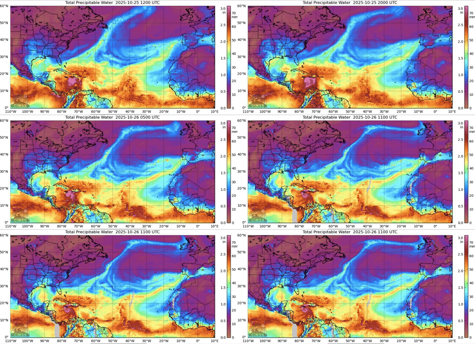
The high TPW feed from the Amazon was cutoff about 8 hours.
This may account for it leveling off at this point.
However, EPAC moisture is starting to flow across Nicaragua into the Caribbean.
Likely will tap into that this late afternoon.
This may account for it leveling off at this point.
However, EPAC moisture is starting to flow across Nicaragua into the Caribbean.
Likely will tap into that this late afternoon.
4 likes
Re: NATL: MELISSA - Hurricane - Discussion
Teban54 wrote:FWIW, both the FL wind of 114 kt and the dropsonade pressure of 952 mb (extrap 949) are weaker than NHC's 5am EDT estimate (120 kt / 944 mb). Although it's possible that the strongest quadrant hasn't been sampled yet.
Could be due to a little eyewall expansion since 5 AM its close to 29 KM across now..
0 likes
-
USTropics
- Professional-Met

- Posts: 2709
- Joined: Sun Aug 12, 2007 3:45 am
- Location: Florida State University
Re: NATL: MELISSA - Hurricane - Discussion
mrbagyo wrote:Why it appears Kermit's making a UTurn
https://s12.gifyu.com/images/b3ubq.jpg
When we see this descent and stall pattern in the flight path, it typically means they are prepping an instrument (most likely a saildrone here):

You can click on every flight data point with this web-app (https://tropicalatlantic.com/recon/reco ... ing=cesium), really cool for seeing flight altitude and other parameters!
2 likes
- Category5Kaiju
- Category 5

- Posts: 4236
- Joined: Thu Dec 24, 2020 12:45 pm
- Location: Seattle
Re: NATL: MELISSA - Hurricane - Discussion
Another Atlantic hurricane season, another "what the hell did I just wake up to" moment.
8 likes
Unless explicitly stated, all info in my posts is based on my own opinions and observations. Tropical storms and hurricanes can be extremely dangerous. Do not think you can beat Mother Nature. Refer to an accredited weather research agency or meteorologist if you need to make serious decisions regarding an approaching storm.
- ScottNAtlanta
- Category 5

- Posts: 2495
- Joined: Sat May 25, 2013 3:11 pm
- Location: Atlanta, GA
Re: NATL: MELISSA - Hurricane - Discussion
Wow...I kind of knew I'd wake up to this, but wow
1 likes
The posts in this forum are NOT official forecast and should not be used as such. They are just the opinion of the poster and may or may not be backed by sound meteorological data. They are NOT endorsed by any professional institution or storm2k.org. For official information, please refer to the NHC and NWS products.
- REDHurricane
- Category 1

- Posts: 434
- Age: 28
- Joined: Sun Jul 03, 2022 2:36 pm
- Location: Northeast Pacific Ocean
Re: NATL: MELISSA - Hurricane - Discussion
ATDoel wrote:Interesting, recon finding a weaker storm than anticipated. Since NHC overshot the intensity, (944 vs 952 actual) do they adjust or just leave the official intensity as is?
Pretty remarkable it’s only at 952mb considering the appearance.
Looks like a bit of dry air intrusion due to northerly shear as mentioned by Levi in yesterday's Tropical Tidbits video, should get mixed out relatively soon I'm guessing

2 likes
-
USTropics
- Professional-Met

- Posts: 2709
- Joined: Sun Aug 12, 2007 3:45 am
- Location: Florida State University
Re: NATL: MELISSA - Hurricane - Discussion
REDHurricane wrote:ATDoel wrote:Interesting, recon finding a weaker storm than anticipated. Since NHC overshot the intensity, (944 vs 952 actual) do they adjust or just leave the official intensity as is?
Pretty remarkable it’s only at 952mb considering the appearance.
Looks like a bit of dry air intrusion due to northerly shear as mentioned by Levi in yesterday's Tropical Tidbits video, should get mixed out relatively soon I'm guessing
https://media1.giphy.com/media/v1.Y2lkPTc5MGI3NjExMWc0azF4NXB2NGxsY3FmNnFoZDFybDhmc2lnb3lydjkzenp4azYzZSZlcD12MV9pbnRlcm5hbF9naWZfYnlfaWQmY3Q9Zw/kRnmqtGgUDWlc2CQ3d/giphy.gif
There is some eyewall melding occurring right now as well (I wouldn't call it an EWRC). Hard to model or forecast how this evolves today, but imo it will likely prevent Melissa from hitting category 5 intensity today. The HAFS-A captures this for 12z (~ right now, 8AM ET):

We're looking at mostly the mid-level structure here, but here is the full radar loop of Melissa as well:

The hurricane models have backed off on maximum intensity occurring later today with the track shifts south and west over night. This doesn't mean Melissa won't achieve category 5 intensity though, as both HAFS-A and HAFS-B show the best conditions for Melissa will be when she starts to turn north on Tuesday morning and gets in an optimal position to Jamaica's terrain + outflow advection channels:


Last edited by USTropics on Sun Oct 26, 2025 7:31 am, edited 1 time in total.
5 likes
- Hurricane2022
- Category 5

- Posts: 1795
- Joined: Tue Aug 23, 2022 11:38 pm
- Location: Araçatuba, Brazil
Re: NATL: MELISSA - Hurricane - Discussion
Melissa is simply not intensifying right now. Likely at ~110 kt/950 at this moment. I still think this will be a powerful 150+ kt MH, but not today.
0 likes
Sorry for the bad English sometimes...!
For reliable and detailed information for any meteorological phenomenon, please consult the National Hurricane Center, Joint Typhoon Warning Center , or your local Meteo Center.
--------
ECCE OMNIA NOVA FACIAM (Ap 21,5).
For reliable and detailed information for any meteorological phenomenon, please consult the National Hurricane Center, Joint Typhoon Warning Center , or your local Meteo Center.
--------
ECCE OMNIA NOVA FACIAM (Ap 21,5).
Return to “Active Storms/Invests - Atlantic/EastPAC/CentralPAC/MED”
Who is online
Users browsing this forum: No registered users and 152 guests