NATL: MELISSA - Aftermath - Discussion
Moderator: S2k Moderators
-
MEANINGLESS_NUMBERS
- Category 2

- Posts: 503
- Joined: Mon Nov 02, 2020 1:43 pm
Re: NATL: MELISSA - Hurricane - Discussion
I know these waters are warm and deep at this time of year but I wonder if we’ll start to see upwelling before landfall.
2 likes
Emily '87, Felix '95, Gert '99, Fabian '03, Humberto '19, Paulette '20, Teddy '20, Fiona '22, Lee '23, Ernesto '24, Humberto/Imelda '25

-
eastcoastFL

- Category 5

- Posts: 3996
- Age: 44
- Joined: Thu Apr 12, 2007 12:29 pm
- Location: Palm City, FL
Re: NATL: MELISSA - Hurricane - Discussion
MEANINGLESS_NUMBERS wrote:I know these waters are warm and deep at this time of year but I wonder if we’ll start to see upwelling before landfall.
Doubtful. She would have to basically park in one spot for days for upwelling to become an issue for her. The water is that warm.
4 likes
Personal Forecast Disclaimer:
The posts in this forum are NOT official forecast and should not be used as such. They are just the opinion of the poster and may or may not be backed by sound meteorological data. They are NOT endorsed by any professional institution or storm2k.org. For official information, please refer to the NHC and NWS products.
The posts in this forum are NOT official forecast and should not be used as such. They are just the opinion of the poster and may or may not be backed by sound meteorological data. They are NOT endorsed by any professional institution or storm2k.org. For official information, please refer to the NHC and NWS products.

Re: NATL: MELISSA - Hurricane - Discussion
931.7mb extrap, down about 1mb from last pass so the rate of deepening is levelling out. Winds aren't particularly different from earlier, 128kt FL winds in the NE.
1 likes

Re: NATL: MELISSA - Hurricane - Discussion
This is the most Cat 5-looking non-Cat 5 I’ve ever seen lol. You’d think it’s like 10 mb deeper than it actually is. Really curious as to why it exhibits the classic Cat 5 structural hallmarks despite falling short in actual intensity. This could also have implications for some of the upper-end Cat 4s with speculated Cat 5 status.
6 likes
Irene '11 Sandy '12 Hermine '16 5/15/2018 Derecho Fay '20 Isaias '20 Elsa '21 Henri '21 Ida '21
I am only a meteorology enthusiast who knows a decent amount about tropical cyclones. Look to the professional mets, the NHC, or your local weather office for the best information.
I am only a meteorology enthusiast who knows a decent amount about tropical cyclones. Look to the professional mets, the NHC, or your local weather office for the best information.

Re: NATL: MELISSA - Hurricane - Discussion
aspen wrote:This is the most Cat 5-looking non-Cat 5 I’ve ever seen lol. You’d think it’s like 10 mb deeper than it actually is. Really curious as to why it exhibits the classic Cat 5 structural hallmarks despite falling short in actual intensity. This could also have implications for some of the upper-end Cat 4s with speculated Cat 5 status.
It's possible that Melissa was just an anomaly. But if we think there's a systematic pattern of "Dvorak but not actual Cat 5s" (for which there's little concrete evidence), then I'd say it affects EPAC even more than the Atlantic. Most borderline Cat 4/5s in the Atlantic had recon coverage at the peak, with Lorenzo and Humberto among the few exceptions that I can think of (and arguably Sam which already started collapsing when recon got there).
2 likes
TC naming lists: retirements and intensity
Most aggressive Advisory #1's in North Atlantic (cr. kevin for starting the list)
Most aggressive Advisory #1's in North Atlantic (cr. kevin for starting the list)
-
Hypercane_Kyle

- Category 5
- Posts: 3465
- Joined: Sat Mar 07, 2015 7:58 pm
- Location: Cape Canaveral, FL
Re: NATL: MELISSA - Hurricane - Discussion
I remember when we all thought Eta was sub-900 nuclear Category 5 and it was actually like in the 930s. This reminds me of that a bit.
1 likes
My posts are my own personal opinion, defer to the National Hurricane Center (NHC) and other NOAA products for decision making during hurricane season.

Re: NATL: MELISSA - Hurricane - Discussion
aspen wrote:This is the most Cat 5-looking non-Cat 5 I’ve ever seen lol. You’d think it’s like 10 mb deeper than it actually is. Really curious as to why it exhibits the classic Cat 5 structural hallmarks despite falling short in actual intensity. This could also have implications for some of the upper-end Cat 4s with speculated Cat 5 status.
It makes sense here - this is the Caribbean in late season. Dvorak is overreliant on convective depth, so a high tropopause can cause overestimates in intensity. Eta's a great extreme example. This is the same reason open Atlantic 130kt+ systems (Sam, Fiona, Jose, Kirk etc) struggle so hard to hit T7.0. I think we've come to recognize here that eye warmth, roundness, and stability plus CDO smoothness are better indicators of extreme intensity. Melissa did briefly have a near-perfect eye, but its CDO has yet to transition past the bursting phase, at least consistently.
6 likes
Kendall -> SLO -> PBC
Memorable Storms: Katrina (for its Florida landfall...) Wilma Matthew Irma
Memorable Storms: Katrina (for its Florida landfall...) Wilma Matthew Irma

Re: NATL: MELISSA - Hurricane - Discussion
aspen wrote:This is the most Cat 5-looking non-Cat 5 I’ve ever seen lol. You’d think it’s like 10 mb deeper than it actually is. Really curious as to why it exhibits the classic Cat 5 structural hallmarks despite falling short in actual intensity. This could also have implications for some of the upper-end Cat 4s with speculated Cat 5 status.
My thinking is that this is similar to what we saw with Eta in 2020 which had super-cold cloud tops and incredible satellite presentation and then recon arrived to find a low-mid level cat4. These late season storms can be misleading due to the extra cold cloud tops. I suspect we’re seeing the same again.
Just because we’ve had lots of cat5s lately doesn’t mean that to get that strong a storm doesn’t need to be pretty much PERFECT, and I wouldn’t say Melissa has looked like that yet. Cold CDO? Yes. Warm eye? Yes. But we had something going on in the west eye wall earlier, and even now the eye is slightly misshapen as if some eyewall process is still ongoing. Not saying she won’t get there though…
2 likes
Re: NATL: MELISSA - Hurricane - Discussion
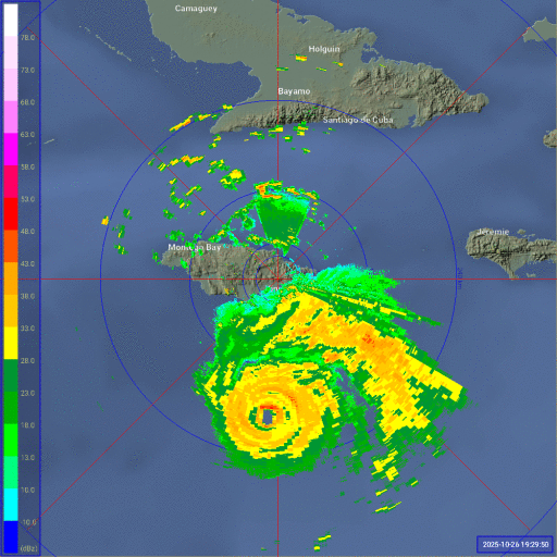
The radar loop makes it look like it's wobbling wsw
2 likes
Re: NATL: MELISSA - Hurricane - Discussion
Ubuntwo wrote:aspen wrote:This is the most Cat 5-looking non-Cat 5 I’ve ever seen lol. You’d think it’s like 10 mb deeper than it actually is. Really curious as to why it exhibits the classic Cat 5 structural hallmarks despite falling short in actual intensity. This could also have implications for some of the upper-end Cat 4s with speculated Cat 5 status.
It makes sense here - this is the Caribbean in late season. Dvorak is overreliant on convective depth, so a high tropopause can cause overestimates in intensity. Eta's a great extreme example. This is the same reason open Atlantic 130kt+ systems (Sam, Fiona, Jose, Kirk etc) struggle so hard to hit T7.0. I think we've come to recognize here that eye warmth, roundness, and stability plus CDO smoothness are better indicators of extreme intensity. Melissa did briefly have a near-perfect eye, but its CDO has yet to transition past the bursting phase, at least consistently.
You said it better than I did haha!
2 likes
-
eastcoastFL
- Category 5
- Posts: 3996
- Age: 44
- Joined: Thu Apr 12, 2007 12:29 pm
- Location: Palm City, FL
Re: NATL: MELISSA - Hurricane - Discussion
BobHarlem wrote:The radar loop makes it look like it's wobbling wsw
https://i.postimg.cc/pTdTyktY/Jamaica-Radar-Melissa-recent-1.gif
I saw that on IR as well but I couldn't tell if it was just the eye contracting or something else.
0 likes
Personal Forecast Disclaimer:
The posts in this forum are NOT official forecast and should not be used as such. They are just the opinion of the poster and may or may not be backed by sound meteorological data. They are NOT endorsed by any professional institution or storm2k.org. For official information, please refer to the NHC and NWS products.
The posts in this forum are NOT official forecast and should not be used as such. They are just the opinion of the poster and may or may not be backed by sound meteorological data. They are NOT endorsed by any professional institution or storm2k.org. For official information, please refer to the NHC and NWS products.
-
Hurricane2022

- Category 5
- Posts: 2093
- Joined: Tue Aug 23, 2022 11:38 pm
- Location: Araçatuba, Brazil
Re: NATL: MELISSA - Hurricane - Discussion
This is Hurricane Kiko from EPAC but with colder tops 
0 likes
Sorry for the bad English sometimes...!
For reliable and detailed information for any meteorological phenomenon, please consult the National Hurricane Center, Joint Typhoon Warning Center , or your local Meteo Center.
--------
ECCE OMNIA NOVA FACIAM (Ap 21,5).
For reliable and detailed information for any meteorological phenomenon, please consult the National Hurricane Center, Joint Typhoon Warning Center , or your local Meteo Center.
--------
ECCE OMNIA NOVA FACIAM (Ap 21,5).

Re: NATL: MELISSA - Hurricane - Discussion
There's definitely a notable wobble to the SW, the latest VDM fixed Melissa at 16.3N when the official track never drops below 16.4N. Obviously its very difficult to predict future trochoidal wobbles but this SW motion is significant and persistent enough that you have to wonder if it will have long term impacts on the future track.
2 likes
-
storm_in_a_teacup

- Category 2
- Posts: 500
- Age: 33
- Joined: Wed Aug 16, 2017 5:01 pm
- Location: Huntsville, Alabama (originally from Houston)
- Contact:
Re: NATL: MELISSA - Hurricane - Discussion
https://www.facebook.com/share/p/1BYZK8jVoT/?mibextid=wwXIfr
Like a black hole with a blinding white accretion disk
“History shows again and again how Nature points out the folly of men” - Blue Oyster Cult
Like a black hole with a blinding white accretion disk
“History shows again and again how Nature points out the folly of men” - Blue Oyster Cult
2 likes
I know I can't straddle the atmosphere...just a tiny storm in your teacup, girl.
-
IsabelaWeather
- Category 1

- Posts: 316
- Age: 36
- Joined: Tue Jul 07, 2020 7:29 am
- Location: Isabela, Puerto Rico
Re: NATL: MELISSA - Hurricane - Discussion
Travorum wrote:There's definitely a notable wobble to the SW, the latest VDM fixed Melissa at 16.3N when the official track never drops below 16.4N. Obviously its very difficult to predict future trochoidal wobbles but this SW motion is significant and persistent enough that you have to wonder if it will have long term impacts on the future track.
NHC specifically said in one of their discussions that a SW movement was probable, but opted to show a due west movement because the SW movement wouldnt likely be sustained.
0 likes
-
Sciencerocks
- Category 5
- Posts: 10193
- Age: 40
- Joined: Thu Jul 06, 2017 1:51 am

Who is online
Users browsing this forum: No registered users and 79 guests