NATL: MELISSA - Aftermath - Discussion
Moderator: S2k Moderators
-
cheezyWXguy

- Category 5

- Posts: 6282
- Joined: Mon Feb 13, 2006 12:29 am
- Location: Dallas, TX
Re: NATL: MELISSA - Hurricane - Discussion
Did recon make another turn again or is TT glitching out with the new data set? The plane was heading nw into the storm but the plane icon is facing due east at the end.
0 likes
-
Hurricane2022

- Category 5
- Posts: 2093
- Joined: Tue Aug 23, 2022 11:38 pm
- Location: Araçatuba, Brazil
Re: NATL: MELISSA - Hurricane - Discussion
Welp that was a hard hit on the plane it seems


I sincerely hope everything is okay with the crew
I sincerely hope everything is okay with the crew
3 likes
Sorry for the bad English sometimes...!
For reliable and detailed information for any meteorological phenomenon, please consult the National Hurricane Center, Joint Typhoon Warning Center , or your local Meteo Center.
--------
ECCE OMNIA NOVA FACIAM (Ap 21,5).
For reliable and detailed information for any meteorological phenomenon, please consult the National Hurricane Center, Joint Typhoon Warning Center , or your local Meteo Center.
--------
ECCE OMNIA NOVA FACIAM (Ap 21,5).
-
Hurricane2022
- Category 5
- Posts: 2093
- Joined: Tue Aug 23, 2022 11:38 pm
- Location: Araçatuba, Brazil
Re: NATL: MELISSA - Hurricane - Discussion
1 likes
Sorry for the bad English sometimes...!
For reliable and detailed information for any meteorological phenomenon, please consult the National Hurricane Center, Joint Typhoon Warning Center , or your local Meteo Center.
--------
ECCE OMNIA NOVA FACIAM (Ap 21,5).
For reliable and detailed information for any meteorological phenomenon, please consult the National Hurricane Center, Joint Typhoon Warning Center , or your local Meteo Center.
--------
ECCE OMNIA NOVA FACIAM (Ap 21,5).

Re: NATL: MELISSA - Hurricane - Discussion
Travorum wrote:Hurricane2022 wrote:I'm still awake because of this reconnaissance mission. Tomorrow is going to be a terribly bad day at work. But at least I'll get to see them find Melissa very stable and cheerful at her 125 kt/930 mb.
This is the best looking mid-range Category 4 that ADT is convinced is a record setting 170kts that I've ever seen.
BTW ADT just hit a CI# of 8.0, might not see that again in the atlantic in my lifetime.----- Current Analysis -----
Date : 27 OCT 2025 Time : 051021 UTC
Lat : 16:16:48 N Lon : 77:35:59 W
CI# /Pressure/ Vmax
8.0 / 888.9mb/170.0kt
Final T# Adj T# Raw T#
8.0 8.2 8.2
Estimated radius of max. wind based on IR : 15 km
Center Temp : +18.8C Cloud Region Temp : -79.0C
If, as a hypothetical, Melissa is at 125 kts right now... The difference of 45 kt would be as if ADT says a Cat 3 when it's in fact a high-end TS.
4 likes
TC naming lists: retirements and intensity
Most aggressive Advisory #1's in North Atlantic (cr. kevin for starting the list)
Most aggressive Advisory #1's in North Atlantic (cr. kevin for starting the list)
-
Hurricane2022
- Category 5
- Posts: 2093
- Joined: Tue Aug 23, 2022 11:38 pm
- Location: Araçatuba, Brazil
Re: NATL: MELISSA - Hurricane - Discussion
The plane still on the way! 65 kt FL so far!
3 likes
Sorry for the bad English sometimes...!
For reliable and detailed information for any meteorological phenomenon, please consult the National Hurricane Center, Joint Typhoon Warning Center , or your local Meteo Center.
--------
ECCE OMNIA NOVA FACIAM (Ap 21,5).
For reliable and detailed information for any meteorological phenomenon, please consult the National Hurricane Center, Joint Typhoon Warning Center , or your local Meteo Center.
--------
ECCE OMNIA NOVA FACIAM (Ap 21,5).
-
Keldeo1997
- Category 2

- Posts: 688
- Joined: Fri Oct 11, 2019 11:35 pm


Re: NATL: MELISSA - Hurricane - Discussion
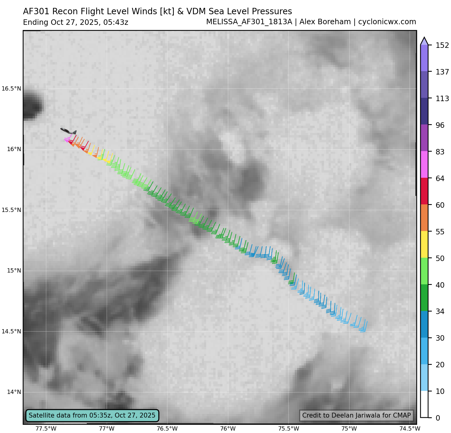
Does the graph imply they were smacked by a vicious downturn? I think I previously read that the flight came out of its initial leg so to come in at a lower altitude, but I dont know if that is factual.
3 likes
Andy D
(For official information, please refer to the NHC and NWS products.)
(For official information, please refer to the NHC and NWS products.)
-
Hurricane2022
- Category 5
- Posts: 2093
- Joined: Tue Aug 23, 2022 11:38 pm
- Location: Araçatuba, Brazil
Re: NATL: MELISSA - Hurricane - Discussion
Officially T8.0 for Melissa. What an incredible night, folks.
https://x.com/DustinLwX/status/1982684729272086782
https://x.com/DustinLwX/status/1982684729272086782
7 likes
Sorry for the bad English sometimes...!
For reliable and detailed information for any meteorological phenomenon, please consult the National Hurricane Center, Joint Typhoon Warning Center , or your local Meteo Center.
--------
ECCE OMNIA NOVA FACIAM (Ap 21,5).
For reliable and detailed information for any meteorological phenomenon, please consult the National Hurricane Center, Joint Typhoon Warning Center , or your local Meteo Center.
--------
ECCE OMNIA NOVA FACIAM (Ap 21,5).
-
WaveBreaking

- Category 2
- Posts: 728
- Joined: Sun Jun 30, 2024 11:33 am
- Location: US
Re: NATL: MELISSA - Hurricane - Discussion
I’m guessing 135kt/920s. Even though Melissa is one of the best looking hurricanes I’ve ever seen, its intensity has been lagging behind its appearance all day. Maybe I’ll be wrong tho.
3 likes
I am NOT a professional meteorologist, so take all of my posts with a grain of salt. My opinions are mine and mine alone.
-
Hurricane2022
- Category 5
- Posts: 2093
- Joined: Tue Aug 23, 2022 11:38 pm
- Location: Araçatuba, Brazil
Re: NATL: MELISSA - Hurricane - Discussion
The next update should show the recon already in the eye.
0 likes
Sorry for the bad English sometimes...!
For reliable and detailed information for any meteorological phenomenon, please consult the National Hurricane Center, Joint Typhoon Warning Center , or your local Meteo Center.
--------
ECCE OMNIA NOVA FACIAM (Ap 21,5).
For reliable and detailed information for any meteorological phenomenon, please consult the National Hurricane Center, Joint Typhoon Warning Center , or your local Meteo Center.
--------
ECCE OMNIA NOVA FACIAM (Ap 21,5).
Re: NATL: MELISSA - Hurricane - Discussion
Hopefully the pilot saved 1/2 of his Calzone for later
2 likes
Andy D
(For official information, please refer to the NHC and NWS products.)
(For official information, please refer to the NHC and NWS products.)

-
Keldeo1997
- Category 2
- Posts: 688
- Joined: Fri Oct 11, 2019 11:35 pm
-
WaveBreaking
- Category 2
- Posts: 728
- Joined: Sun Jun 30, 2024 11:33 am
- Location: US
Re: NATL: MELISSA - Hurricane - Discussion
923.2mbar extrap/140kt FL winds
1 likes
I am NOT a professional meteorologist, so take all of my posts with a grain of salt. My opinions are mine and mine alone.
Re: NATL: MELISSA - Hurricane - Discussion
FL 140 kt, SFMR 148 kt, extrap pressure 923.2 mb.
Edit: This is the SE quad, for clarification. NW quad has higher winds as seen below.
Edit: This is the SE quad, for clarification. NW quad has higher winds as seen below.
Last edited by Teban54 on Mon Oct 27, 2025 1:09 am, edited 1 time in total.
3 likes
TC naming lists: retirements and intensity
Most aggressive Advisory #1's in North Atlantic (cr. kevin for starting the list)
Most aggressive Advisory #1's in North Atlantic (cr. kevin for starting the list)
-
Hurricane2022
- Category 5
- Posts: 2093
- Joined: Tue Aug 23, 2022 11:38 pm
- Location: Araçatuba, Brazil
Re: NATL: MELISSA - Hurricane - Discussion
Keldeo1997 wrote:923 Extap
Guess now I can "rest in peace"
3 likes
Sorry for the bad English sometimes...!
For reliable and detailed information for any meteorological phenomenon, please consult the National Hurricane Center, Joint Typhoon Warning Center , or your local Meteo Center.
--------
ECCE OMNIA NOVA FACIAM (Ap 21,5).
For reliable and detailed information for any meteorological phenomenon, please consult the National Hurricane Center, Joint Typhoon Warning Center , or your local Meteo Center.
--------
ECCE OMNIA NOVA FACIAM (Ap 21,5).
-
Stormgodess

- Category 1

- Posts: 316
- Joined: Mon Sep 14, 2020 1:31 am
Re: NATL: MELISSA - Hurricane - Discussion
I wonder how much data refreshing a half dozen pages non-stop uses? 
4 likes
Re: NATL: MELISSA - Hurricane - Discussion
I'll go with 917.5 mb with 160 mph (winds still slightly catching up to the pressure fall)
2 likes
Andy D
(For official information, please refer to the NHC and NWS products.)
(For official information, please refer to the NHC and NWS products.)
-
Hurricane2022
- Category 5
- Posts: 2093
- Joined: Tue Aug 23, 2022 11:38 pm
- Location: Araçatuba, Brazil
Re: NATL: MELISSA - Hurricane - Discussion
NHC still hasn't issued the intermediate advisory 
-----
Edit: nvm
-----
Edit: nvm
Min pressure: 926 mb
Max sustained: 150 mph
Max sustained: 150 mph
Last edited by Hurricane2022 on Mon Oct 27, 2025 12:59 am, edited 1 time in total.
2 likes
Sorry for the bad English sometimes...!
For reliable and detailed information for any meteorological phenomenon, please consult the National Hurricane Center, Joint Typhoon Warning Center , or your local Meteo Center.
--------
ECCE OMNIA NOVA FACIAM (Ap 21,5).
For reliable and detailed information for any meteorological phenomenon, please consult the National Hurricane Center, Joint Typhoon Warning Center , or your local Meteo Center.
--------
ECCE OMNIA NOVA FACIAM (Ap 21,5).
-
ElectricStorm

- Category 5
- Posts: 5157
- Age: 25
- Joined: Tue Aug 13, 2019 11:23 pm
- Location: Norman, OK
Re: NATL: MELISSA - Hurricane - Discussion
First salmon barbs I've seen so far, SE quad is impressive. Let's see if NW quad can surpass it
2 likes
B.S Meteorology, University of Oklahoma '25
Please refer to the NHC, NWS, or SPC for official information.
Please refer to the NHC, NWS, or SPC for official information.
Who is online
Users browsing this forum: No registered users and 36 guests