
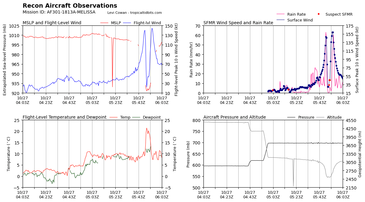
Looks like pressure's down to 923.2mb extrap, FL winds 140kts and SFMR 148kts. This is in the SE, there's potentially stronger winds on the way out in the north. The HDOB got cut off but the last entry had 136kt SFMR with 931mb extrap, there's probably stronger winds right at the start of the next HDOB.
Again with the caveat of "if you trust SFMR in high end hurricanes" an even blend is borderline 135/140kts
NATL: MELISSA - Aftermath - Discussion
Moderator: S2k Moderators
-
PavelGaborik10
- Category 1

- Posts: 472
- Joined: Tue Sep 04, 2018 3:23 pm
Re: NATL: MELISSA - Hurricane - Discussion
WaveBreaking wrote:I’m guessing 135kt/920s. Even though Melissa is one of the best looking hurricanes I’ve ever seen, its intensity has been lagging behind its appearance all day. Maybe I’ll be wrong tho.
I'll go with the same winds(135 KTS) but pressure 926.
1 likes


Re: NATL: MELISSA - Hurricane - Discussion
Stormgodess wrote:I wonder how much data refreshing a half dozen pages non-stop uses?

You and I both LOL, yet somehow we both missed the updated post (above)
2 likes
Andy D
(For official information, please refer to the NHC and NWS products.)
(For official information, please refer to the NHC and NWS products.)
-
Hurricane2022

- Category 5

- Posts: 2093
- Joined: Tue Aug 23, 2022 11:38 pm
- Location: Araçatuba, Brazil
Re: NATL: MELISSA - Hurricane - Discussion
Satellite images indicate that maximum sustained winds have
increased to near 150 mph (240 km/h) with higher gusts. Melissa is
a category 4 hurricane on the Saffir-Simpson Hurricane Wind Scale.
Additional intensification is forecast today, followed by
fluctuations in intensity before Melissa reaches Jamaica. Melissa
is expected to be a powerful major hurricane when making landfall
in Jamaica and southeastern Cuba.
Looks like they issued the advisory before recon reached the eye.
If the plane finds 152+ FL winds in the NW wall, we should see an update coming in 30 min.
6 likes
Sorry for the bad English sometimes...!
For reliable and detailed information for any meteorological phenomenon, please consult the National Hurricane Center, Joint Typhoon Warning Center , or your local Meteo Center.
--------
ECCE OMNIA NOVA FACIAM (Ap 21,5).
For reliable and detailed information for any meteorological phenomenon, please consult the National Hurricane Center, Joint Typhoon Warning Center , or your local Meteo Center.
--------
ECCE OMNIA NOVA FACIAM (Ap 21,5).
Re: NATL: MELISSA - Hurricane - Discussion
Yeah....... if I'm NHC, I might have just sat back on that brief update pending the NW & NE quadrant sampling - just say'in.
0 likes
Andy D
(For official information, please refer to the NHC and NWS products.)
(For official information, please refer to the NHC and NWS products.)
Re: NATL: MELISSA - Hurricane - Discussion
Hurricane2022 wrote:Satellite images indicate that maximum sustained winds have
increased to near 150 mph (240 km/h) with higher gusts. Melissa is
a category 4 hurricane on the Saffir-Simpson Hurricane Wind Scale.
Additional intensification is forecast today, followed by
fluctuations in intensity before Melissa reaches Jamaica. Melissa
is expected to be a powerful major hurricane when making landfall
in Jamaica and southeastern Cuba.
Looks like they issued the advisory before recon reached the eye.
If the plane finds 152+ FL winds in the NW pass, we should see an update coming in 30 min.
Somehow this always ends up happening with recon—they make their first pass minutes after the NHC advisory time. It happens so often you'd think they scheduled it (maybe that's why recon loitered for 20 minutes
2 likes
-
ElectricStorm

- Category 5
- Posts: 5157
- Age: 25
- Joined: Tue Aug 13, 2019 11:23 pm
- Location: Norman, OK
Re: NATL: MELISSA - Hurricane - Discussion
144 FL/159 SFMR...
2 likes
B.S Meteorology, University of Oklahoma '25
Please refer to the NHC, NWS, or SPC for official information.
Please refer to the NHC, NWS, or SPC for official information.

Re: NATL: MELISSA - Hurricane - Discussion
NW quad: 144 kt FL, 159 kt SFMR
2 likes
TC naming lists: retirements and intensity
Most aggressive Advisory #1's in North Atlantic (cr. kevin for starting the list)
Most aggressive Advisory #1's in North Atlantic (cr. kevin for starting the list)
-
Hurricane2022
- Category 5
- Posts: 2093
- Joined: Tue Aug 23, 2022 11:38 pm
- Location: Araçatuba, Brazil
Re: NATL: MELISSA - Hurricane - Discussion

4 likes
Sorry for the bad English sometimes...!
For reliable and detailed information for any meteorological phenomenon, please consult the National Hurricane Center, Joint Typhoon Warning Center , or your local Meteo Center.
--------
ECCE OMNIA NOVA FACIAM (Ap 21,5).
For reliable and detailed information for any meteorological phenomenon, please consult the National Hurricane Center, Joint Typhoon Warning Center , or your local Meteo Center.
--------
ECCE OMNIA NOVA FACIAM (Ap 21,5).
Re: NATL: MELISSA - Hurricane - Discussion
ElectricStorm wrote:144 FL/159 SFMR...
yeah that'll do it, I guess those winds finally mixed down
Last edited by Travorum on Mon Oct 27, 2025 1:08 am, edited 1 time in total.
0 likes
-
WaveBreaking

- Category 2

- Posts: 728
- Joined: Sun Jun 30, 2024 11:33 am
- Location: US
Re: NATL: MELISSA - Hurricane - Discussion
Recon found 144kt FL winds in the NW quad
0 likes
I am NOT a professional meteorologist, so take all of my posts with a grain of salt. My opinions are mine and mine alone.
-
Keldeo1997
- Category 2
- Posts: 688
- Joined: Fri Oct 11, 2019 11:35 pm
Re: NATL: MELISSA - Hurricane - Discussion
With such a huge discrepancy in FL and SFMR winds, as well as continued skepticism of SFMR at higher ends... Will the 159 kt SFMR be thrown out completely?
2 likes
TC naming lists: retirements and intensity
Most aggressive Advisory #1's in North Atlantic (cr. kevin for starting the list)
Most aggressive Advisory #1's in North Atlantic (cr. kevin for starting the list)
-
ElectricStorm
- Category 5
- Posts: 5157
- Age: 25
- Joined: Tue Aug 13, 2019 11:23 pm
- Location: Norman, OK
Re: NATL: MELISSA - Hurricane - Discussion
Eye drop supports 923-924mb, pretty nice drop since last mission
4 likes
B.S Meteorology, University of Oklahoma '25
Please refer to the NHC, NWS, or SPC for official information.
Please refer to the NHC, NWS, or SPC for official information.
-
PavelGaborik10
- Category 1
- Posts: 472
- Joined: Tue Sep 04, 2018 3:23 pm
Re: NATL: MELISSA - Hurricane - Discussion
Data looks to support cat 5 to my eye, granted I'm not professional.
0 likes
Re: NATL: MELISSA - Hurricane - Discussion
In my opinion, the latest recon justifies 160mph, but it’s even more shocking to me that they didn’t go with 155.
0 likes
-
mrbagyo

- Category 5
- Posts: 3998
- Age: 33
- Joined: Thu Apr 12, 2012 9:18 am
- Location: 14.13N 120.98E
- Contact:
Re: NATL: MELISSA - Hurricane - Discussion
923-924
145 knots on 06z update?
145 knots on 06z update?
0 likes
The posts in this forum are NOT official forecast and should not be used as such. They are just the opinion of the poster and may or may not be backed by sound meteorological data. They are NOT endorsed by any professional institution or storm2k.org. For official information, please refer to RSMC, NHC and NWS products.
Re: NATL: MELISSA - Hurricane - Discussion
Teban54 wrote:With such a huge discrepancy in FL and SFMR winds, as well as continued skepticism of SFMR at higher ends... Will the 159 kt SFMR be thrown out completely?
I think maybe not completely disregarded but maybe weighted less; between the CI# 8.1 ADT, the T7.5 subjective fix that will probably come through at 06z, the FL winds, and the SFMR measurement, there's probably enough support for at least 140kts.
0 likes
-
Chris_in_Tampa
- Category 5
- Posts: 5101
- Age: 42
- Joined: Thu Jun 21, 2007 11:06 pm
- Location: Tampa, Florida, USA
- Contact:
Re: NATL: MELISSA - Hurricane - Discussion
Please see the SFMR thread at the end for context. However, the storm is strengthening.
The 2am EDT advisory was posted at 1:57:33am EDT.
At 1:54am EDT an HDOB through the center was posted from recon ending at 1:53:30am EDT.
That ob in the southeast quadrant from where the plane was incoming from to the center had winds of (OB19, ending at 1:53am EDT):
Flight Level Wind (30 sec. Avg.): 155mph
Peak (10 sec. Avg.) Flight Level Wind: 161mph
SFMR Peak (10s Avg.) Sfc. Wind: 170mph
In the northwest quadrant in the ten minutes after that (OB20, ending at 2:03am EDT):
Flight Level Wind (30 sec. Avg.): 161mph
Peak (10 sec. Avg.) Flight Level Wind: 166mph
SFMR Peak (10s Avg.) Sfc. Wind: 183mph
See this thread on Bluesky about SFMR being unreliable from earlier NOAA mission where SFMR was turned off:
https://bsky.app/profile/did:plc:ce6exp ... 4fslz5zk2b
Alan Gerard from earlier mission: "Seems as if recon is finding #Melissa potentially intensifying again. Eye dropsonde measured 949 mb with 26 kt of wind at sfc, implying 946-7 mb central pressure. 115 kt SFMR winds in NW quad and 122 kt FL winds in SE quad."
James Franklin: "Alan, unless something has changed recently, the SFMR data aren’t considered properly calibrated. NOAA turned off the transmission of the SFMR but that’s harder to do on the AF C-130s."
Alan Gerard: "Thanks for the update on that. I didn’t know if that was the situation still or not. I will avoid mentioning going forward"
James Franklin: "I haven’t heard anything and I understand the fixes are non-trivial, so yeah, use with caution, especially at the high end."
3 likes

Re: NATL: MELISSA - Hurricane - Discussion
Now 144kt flight level winds and 159kt sfmr estimated winds,unrealiable but still useful information.
If eyewall will stays intact another hour or two, I think we may find higher winds in the southwest/northeast eye pass.
Looks like I wont be sleeping anytime soon.
If eyewall will stays intact another hour or two, I think we may find higher winds in the southwest/northeast eye pass.
Looks like I wont be sleeping anytime soon.
Last edited by Jr0d on Mon Oct 27, 2025 1:17 am, edited 1 time in total.
0 likes
Who is online
Users browsing this forum: No registered users and 61 guests