NATL: MELISSA - Aftermath - Discussion: Josh Morgerman video of Melissa is up

Moderator: S2k Moderators

Message
Author
User avatar
Nimbus
Category 5
Category 5
Posts: 5444
Joined: Mon Jul 19, 2004 10:54 am

Re: NATL: MELISSA - Hurricane - Discussion

#1341 Postby Nimbus » Mon Oct 27, 2025 6:10 am

Beef Stew wrote:Recon is really getting bounced around this run it seems.


I think they must be sampling or timing their entry through the core, its sub 920 now.
The trough looks pathetic and the NHC is calling for landfall in Jamaica as a category 5 hurricane.
Bermuda forecast with 90 mph winds won't be as bad they are built for that.
1 likes   

User avatar
GCANE
S2K Supporter
S2K Supporter
Posts: 12072
Joined: Mon Oct 22, 2007 8:03 am

Re: NATL: MELISSA - Hurricane - Discussion

#1342 Postby GCANE » Mon Oct 27, 2025 6:12 am

Lightning has increased dramatically since last evening in both the eye and feeder band.
0 likes   

User avatar
Hypercane_Kyle
Category 5
Category 5
Posts: 3465
Joined: Sat Mar 07, 2015 7:58 pm
Location: Cape Canaveral, FL

Re: NATL: MELISSA - Hurricane - Discussion

#1343 Postby Hypercane_Kyle » Mon Oct 27, 2025 6:14 am

My guess is Melissa is around 909mb. We'll see what recon finds here in a minute.
Last edited by Hypercane_Kyle on Mon Oct 27, 2025 6:17 am, edited 1 time in total.
0 likes   
My posts are my own personal opinion, defer to the National Hurricane Center (NHC) and other NOAA products for decision making during hurricane season.

User avatar
Beef Stew
Category 2
Category 2
Posts: 642
Joined: Sat May 30, 2020 11:31 am
Location: South Florida

Re: NATL: MELISSA - Hurricane - Discussion

#1344 Postby Beef Stew » Mon Oct 27, 2025 6:16 am

Should be getting the first center pass (NW-SE) from NOAA within the next 30 minutes or so. Any guesses on what they’ll find? My guess is Melissa is probably around 913 mb at this point and quickly approaching the sub 910’s. Winds 140-145 kts.
0 likes   

User avatar
Beef Stew
Category 2
Category 2
Posts: 642
Joined: Sat May 30, 2020 11:31 am
Location: South Florida

Re: NATL: MELISSA - Hurricane - Discussion

#1345 Postby Beef Stew » Mon Oct 27, 2025 6:24 am

Center pass data should be coming any minute now
0 likes   

User avatar
Beef Stew
Category 2
Category 2
Posts: 642
Joined: Sat May 30, 2020 11:31 am
Location: South Florida

Re: NATL: MELISSA - Hurricane - Discussion

#1346 Postby Beef Stew » Mon Oct 27, 2025 6:28 am

912.4 extrap
0 likes   

User avatar
Hypercane_Kyle
Category 5
Category 5
Posts: 3465
Joined: Sat Mar 07, 2015 7:58 pm
Location: Cape Canaveral, FL

Re: NATL: MELISSA - Hurricane - Discussion

#1347 Postby Hypercane_Kyle » Mon Oct 27, 2025 6:28 am

912mb extrapolated, flight level winds 155 knots.
1 likes   
My posts are my own personal opinion, defer to the National Hurricane Center (NHC) and other NOAA products for decision making during hurricane season.

User avatar
Kazmit
Category 5
Category 5
Posts: 2258
Age: 22
Joined: Mon Jul 25, 2016 8:49 am
Location: Bermuda

Re: NATL: MELISSA - Hurricane - Discussion

#1348 Postby Kazmit » Mon Oct 27, 2025 6:29 am

My guess of 912 mb was right (trust me, that was my guess even though I didn’t post it).
0 likes   
Igor 2010, Sandy 2012, Fay 2014, Gonzalo 2014, Joaquin 2015, Nicole 2016, Humberto 2019, Imelda 2025

I am only a tropical weather enthusiast. My predictions are not official and may or may not be backed by sound meteorological data. For official information, please refer to the NHC and NWS products.

User avatar
Kazmit
Category 5
Category 5
Posts: 2258
Age: 22
Joined: Mon Jul 25, 2016 8:49 am
Location: Bermuda

Re: NATL: MELISSA - Hurricane - Discussion

#1349 Postby Kazmit » Mon Oct 27, 2025 6:30 am

Probably at least 145kts now based on that pass.
1 likes   
Igor 2010, Sandy 2012, Fay 2014, Gonzalo 2014, Joaquin 2015, Nicole 2016, Humberto 2019, Imelda 2025

I am only a tropical weather enthusiast. My predictions are not official and may or may not be backed by sound meteorological data. For official information, please refer to the NHC and NWS products.

User avatar
Beef Stew
Category 2
Category 2
Posts: 642
Joined: Sat May 30, 2020 11:31 am
Location: South Florida

Re: NATL: MELISSA - Hurricane - Discussion

#1350 Postby Beef Stew » Mon Oct 27, 2025 6:32 am

Uniform 150+ kt FL winds in all quadrants right now it seems. The next NE to SW pass should find strong enough winds to support 145 if not 150 kts.
0 likes   

michelinj
Tropical Depression
Tropical Depression
Posts: 73
Joined: Mon Aug 06, 2018 4:59 pm

Re: NATL: MELISSA - Hurricane - Discussion

#1351 Postby michelinj » Mon Oct 27, 2025 6:34 am

That dropsonde in the NW eyewall is pretty incredible. 159kt at the surface, with 167kt just above. Could well just be a gust that it got but even so.
4 likes   

User avatar
mrbagyo
Category 5
Category 5
Posts: 3962
Age: 33
Joined: Thu Apr 12, 2012 9:18 am
Location: 14.13N 120.98E
Contact:

Re: NATL: MELISSA - Hurricane - Discussion

#1352 Postby mrbagyo » Mon Oct 27, 2025 6:34 am

So this thing is now deeper than Irma huh
0 likes   
The posts in this forum are NOT official forecast and should not be used as such. They are just the opinion of the poster and may or may not be backed by sound meteorological data. They are NOT endorsed by any professional institution or storm2k.org. For official information, please refer to RSMC, NHC and NWS products.

User avatar
Kazmit
Category 5
Category 5
Posts: 2258
Age: 22
Joined: Mon Jul 25, 2016 8:49 am
Location: Bermuda

Re: NATL: MELISSA - Hurricane - Discussion

#1353 Postby Kazmit » Mon Oct 27, 2025 6:40 am

mrbagyo wrote:So this thing is now deeper than Irma huh

It’s incredibly deep for how relatively small of a storm it is. I think the winds still have some catching up to do.
2 likes   
Igor 2010, Sandy 2012, Fay 2014, Gonzalo 2014, Joaquin 2015, Nicole 2016, Humberto 2019, Imelda 2025

I am only a tropical weather enthusiast. My predictions are not official and may or may not be backed by sound meteorological data. For official information, please refer to the NHC and NWS products.

User avatar
mrbagyo
Category 5
Category 5
Posts: 3962
Age: 33
Joined: Thu Apr 12, 2012 9:18 am
Location: 14.13N 120.98E
Contact:

Re: NATL: MELISSA - Hurricane - Discussion

#1354 Postby mrbagyo » Mon Oct 27, 2025 6:40 am

The C130 from Curacao is now entering the eye
0 likes   
The posts in this forum are NOT official forecast and should not be used as such. They are just the opinion of the poster and may or may not be backed by sound meteorological data. They are NOT endorsed by any professional institution or storm2k.org. For official information, please refer to RSMC, NHC and NWS products.

User avatar
Beef Stew
Category 2
Category 2
Posts: 642
Joined: Sat May 30, 2020 11:31 am
Location: South Florida

Re: NATL: MELISSA - Hurricane - Discussion

#1355 Postby Beef Stew » Mon Oct 27, 2025 6:43 am

Should have a fix from the AF plane any minute now.
0 likes   

User avatar
kevin
Category 5
Category 5
Posts: 2878
Age: 27
Joined: Wed Aug 28, 2019 4:35 am

Re: NATL: MELISSA - Hurricane - Discussion

#1356 Postby kevin » Mon Oct 27, 2025 6:43 am

Holy sh*t, NOAA2 measured an eye temperature of +28.4C. That has to be the warmest eye I've ever seen during a recon pass and relatively close to the world-record: +34.0C in typhoon Judy, 1979.
4 likes   

User avatar
Blown Away
S2K Supporter
S2K Supporter
Posts: 10253
Joined: Wed May 26, 2004 6:17 am

Re: NATL: MELISSA - Hurricane - Discussion

#1357 Postby Blown Away » Mon Oct 27, 2025 6:44 am
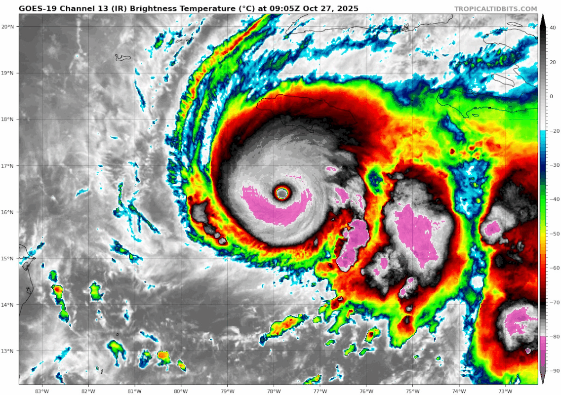
Image

FORECAST POSITIONS AND MAX WINDS

INIT 27/0900Z 16.4N 77.8W 140 KT 160 MPH
12H 27/1800Z 16.6N 78.1W 145 KT 165 MPH
24H 28/0600Z 17.3N 78.1W 140 KT 160 MPH
36H 28/1800Z 18.5N 77.3W 115 KT 130 MPH...NORTH COAST OF JAMAICA
48H 29/0600Z 20.1N 76.0W 105 KT 120 MPH...OVER SE CUBA
60H 29/1800Z 22.1N 74.4W 90 KT 105 MPH...NEAR SE BAHAMAS
72H 30/0600Z 24.7N 72.3W 85 KT 100 MPH
96H 31/0600Z 32.3N 65.1W 80 KT 90 MPH...NEAR BERMUDA
120H 01/0600Z 41.4N 53.5W 60 KT 70 MPH...POST-TROP/EXTRATROP


Melissa is not predicted to go farther W than 78.1, she still looks solid WNW. I believe if she tracks farther W now that will result in a farther W landfall on Jamaica.
Last edited by Blown Away on Mon Oct 27, 2025 6:49 am, edited 1 time in total.
0 likes   
Hurricane Eye Experience: David 79, Irene 99, Frances 04, Jeanne 04, Wilma 05… Hurricane Brush Experience: Andrew 92, Erin 95, Floyd 99, Matthew 16, Irma 17, Ian 22, Nicole 22…

User avatar
kevin
Category 5
Category 5
Posts: 2878
Age: 27
Joined: Wed Aug 28, 2019 4:35 am

Re: NATL: MELISSA - Hurricane - Discussion

#1358 Postby kevin » Mon Oct 27, 2025 6:45 am

AF plane, 912.9 mb extrapolated with 10 kt winds nearby. Also measured 158 kt FL winds is good enough imo to support an upgrade to 145 kt.
2 likes   

User avatar
mrbagyo
Category 5
Category 5
Posts: 3962
Age: 33
Joined: Thu Apr 12, 2012 9:18 am
Location: 14.13N 120.98E
Contact:

Re: NATL: MELISSA - Hurricane - Discussion

#1359 Postby mrbagyo » Mon Oct 27, 2025 6:45 am

912.9 Extrap
158 FL
167 SFMR
0 likes   
The posts in this forum are NOT official forecast and should not be used as such. They are just the opinion of the poster and may or may not be backed by sound meteorological data. They are NOT endorsed by any professional institution or storm2k.org. For official information, please refer to RSMC, NHC and NWS products.

dukeblue219
S2K Supporter
S2K Supporter
Posts: 556
Joined: Fri Sep 30, 2016 3:52 pm

Re: NATL: MELISSA - Hurricane - Discussion

#1360 Postby dukeblue219 » Mon Oct 27, 2025 6:46 am

I see 167kt SFMR on the Air Force plane, but did I read earlier that there was an issue with the SFMR calibration?
0 likes   


Return to “2025”

Who is online

Users browsing this forum: No registered users and 37 guests