
VDM from Kermit
A. Time of Center Fix: 27th day of the month at 11:21:48Z
B. Center Fix Coordinates: 16.35N 77.95W
D. Minimum Sea Level Pressure: 916mb (27.05 inHg)
F. Eye Character: Closed
G. Eye Shape & Diameter: Circular with a diameter of 10 nautical miles (12 statute miles)
J. Maximum Flight Level Wind Inbound: From 37° at 155kts (From the NE at 178.4mph)
Flight Level = 750mb nominal
NATL: MELISSA - Aftermath - Discussion
Moderator: S2k Moderators
-
MEANINGLESS_NUMBERS
- Category 2

- Posts: 503
- Joined: Mon Nov 02, 2020 1:43 pm
Re: NATL: MELISSA - Hurricane - Discussion
mrbagyo wrote:912.9 Extrap
158 FL
167 SFMR
Wild SFMR - was it flagged?
0 likes
Emily '87, Felix '95, Gert '99, Fabian '03, Humberto '19, Paulette '20, Teddy '20, Fiona '22, Lee '23, Ernesto '24, Humberto/Imelda '25

Re: NATL: MELISSA - Hurricane - Discussion
Dropsonde supports 912 - 913 mb. Slightly lower RH at altitude, but the surface RH is still high at 93%.

0 likes
Re: NATL: MELISSA - Hurricane - Discussion
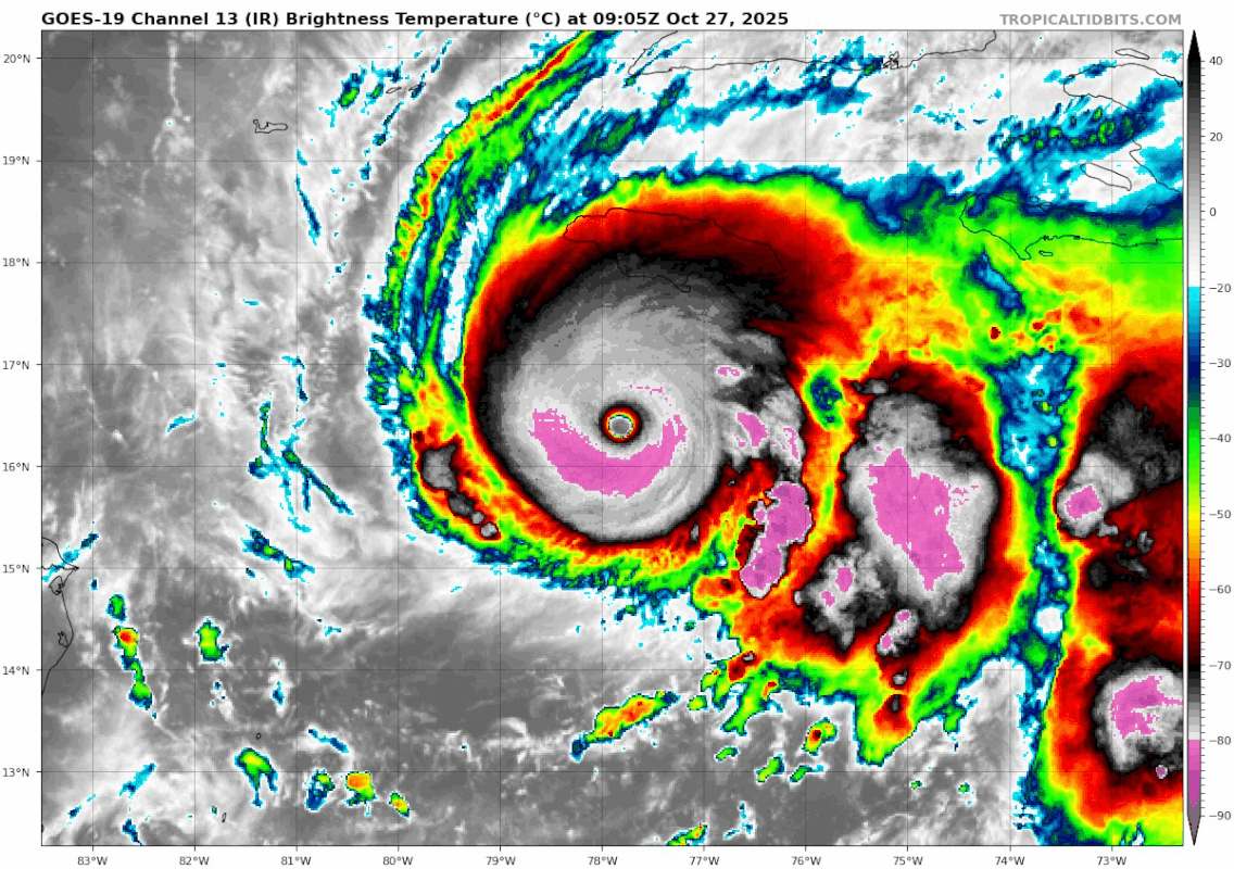
Blown Away wrote: https://i.postimg.cc/HnWrBLbh/goes19-ir ... 270905.gifFORECAST POSITIONS AND MAX WINDS
INIT 27/0900Z 16.4N 77.8W 140 KT 160 MPH
12H 27/1800Z 16.6N 78.1W 145 KT 165 MPH
24H 28/0600Z 17.3N 78.1W 140 KT 160 MPH
36H 28/1800Z 18.5N 77.3W 115 KT 130 MPH...NORTH COAST OF JAMAICA
48H 29/0600Z 20.1N 76.0W 105 KT 120 MPH...OVER SE CUBA
60H 29/1800Z 22.1N 74.4W 90 KT 105 MPH...NEAR SE BAHAMAS
72H 30/0600Z 24.7N 72.3W 85 KT 100 MPH
96H 31/0600Z 32.3N 65.1W 80 KT 90 MPH...NEAR BERMUDA
120H 01/0600Z 41.4N 53.5W 60 KT 70 MPH...POST-TROP/EXTRATROP
Melissa is not predicted to go farther W than 78.1, she still looks solid WNW. I believe if she tracks farther W now that will result in a farther W landfall on Jamaica.
Interpolated curve between the points (12 hours is a huge gap this close) it could still get to about 78.2 it's still about right, I think it winds up near Treasure beach.
1 likes

Re: NATL: MELISSA - Hurricane - Discussion
I’m guessing the NHC is probably waiting for data from the NE quadrant before making the bump to 145kts.
1 likes
Re: NATL: MELISSA - Hurricane - Discussion
We're now entering all-time territory. Here are all the sub-920 hurricanes in the Atlantic. Melissa is now at #15 on the all-time Atlantic list in terms of pressure.
Edit: updated to include category 4 hurricanes.
880s
882 - Wilma (2005)
888 - Gilbert (1988)
890s
892 - Labor Day (1935)
895 - Rita (2005)
895 - Milton (2024)
899 - Allen (1980)
900s
900 - Camille (1969)
902 - Katrina (2005)
905 - Mitch (1998)
905 - Dean (2007)
908 - Maria (2017)
910s
910 - Cuba (1924)
910 - Ivan (2004)
910 - Dorian (2019)
913 - Melissa (2025)
914 - Janet (1955)
914 - Hattie (1961)
914 - Irma (2017)
915 - Cuba (1932)
915 - Isabel (2003)
915 - Erin (2025)
916 - Opal (1995)
917 - Iota (2020)
918 - Great Atlantic (1944)
918 - Hugo (1989)
919 - Esther (1961)
919 - Gloria (1985)
919 - Michael (2018)
Last edited by kevin on Mon Oct 27, 2025 7:03 am, edited 3 times in total.
5 likes
-
tolakram
- Admin

- Posts: 20186
- Age: 62
- Joined: Sun Aug 27, 2006 8:23 pm
- Location: Florence, KY (name is Mark)
Re: NATL: MELISSA - Hurricane - Discussion
saved loop

source: https://weather.cod.edu/satrad/?parms=meso-meso2-02-48-0-100-1&checked=usint-map&colorbar=undefined
source: https://weather.cod.edu/satrad/?parms=meso-meso2-02-48-0-100-1&checked=usint-map&colorbar=undefined
5 likes
M a r k
- - - - -
Join us in chat: Storm2K Chatroom Invite. Android and IOS apps also available.
The posts in this forum are NOT official forecasts and should not be used as such. Posts are NOT endorsed by any professional institution or STORM2K.org. For official information and forecasts, please refer to NHC and NWS products.

Re: NATL: MELISSA - Hurricane - Discussion
kevin wrote:We're now entering all-time territory. Here are all the sub-920 hurricanes in the Atlantic. Melissa is now at #15 on the all-time Atlantic list in terms of pressure.
880s
882 - Wilma (2005)
888 - Gilbert (1988)
890s
892 - Labor Day (1935)
895 - Rita (2005)
895 - Milton (2024)
899 - Allen (1980)
900s
900 - Camille (1969)
902 - Katrina (2005)
905 - Mitch (1998)
905 - Dean (2007)
908 - Maria (2017)
910s
910 - Cuba (1924)
910 - Ivan (2004)
910 - Dorian (2019)
913 - Melissa (2025)
914 - Janet (1955)
914 - Hattie (1961)
914 - Irma (2017)
915 - Cuba (1932)
915 - Isabel (2003)
915 - Erin (2025)
918 - Great Atlantic (1944)
918 - Hugo (1989)
919 - Esther (1961)
919 - Michael (2018)
Great post- but, for what it’s worth, while they weren’t category 5’s, Gloria, Opal, and Iota (still a category 5 in my heart) were all sub-920 as well.
1 likes
Re: NATL: MELISSA - Hurricane - Discussion
Beef Stew wrote:kevin wrote:We're now entering all-time territory. Here are all the sub-920 hurricanes in the Atlantic. Melissa is now at #15 on the all-time Atlantic list in terms of pressure.
880s
882 - Wilma (2005)
888 - Gilbert (1988)
890s
892 - Labor Day (1935)
895 - Rita (2005)
895 - Milton (2024)
899 - Allen (1980)
900s
900 - Camille (1969)
902 - Katrina (2005)
905 - Mitch (1998)
905 - Dean (2007)
908 - Maria (2017)
910s
910 - Cuba (1924)
910 - Ivan (2004)
910 - Dorian (2019)
913 - Melissa (2025)
914 - Janet (1955)
914 - Hattie (1961)
914 - Irma (2017)
915 - Cuba (1932)
915 - Isabel (2003)
915 - Erin (2025)
918 - Great Atlantic (1944)
918 - Hugo (1989)
919 - Esther (1961)
919 - Michael (2018)
Great post- but, for what it’s worth, while they weren’t category 5’s, Gloria, Opal, and Iota (still a category 5 in my heart) were all sub-920 as well.
I thought I also checked the cat 4 hurricanes, but apparently I missed a few. Thanks, I'll update the list now.
0 likes
-
MEANINGLESS_NUMBERS
- Category 2
- Posts: 503
- Joined: Mon Nov 02, 2020 1:43 pm
Re: NATL: MELISSA - Hurricane - Discussion
Were both planes passing through the eye at the same time?
0 likes
Emily '87, Felix '95, Gert '99, Fabian '03, Humberto '19, Paulette '20, Teddy '20, Fiona '22, Lee '23, Ernesto '24, Humberto/Imelda '25
Re: NATL: MELISSA - Hurricane - Discussion
MEANINGLESS_NUMBERS wrote:Were both planes passing through the eye at the same time?
AF passed through about ~20 minutes after NOAA
0 likes
-
eastcoastFL

- Category 5

- Posts: 3996
- Age: 44
- Joined: Thu Apr 12, 2007 12:29 pm
- Location: Palm City, FL
Re: NATL: MELISSA - Hurricane - Discussion
Does anyone know where Josh is riding out the storm? Any other chasers decide to go to Jamaica?
0 likes
Personal Forecast Disclaimer:
The posts in this forum are NOT official forecast and should not be used as such. They are just the opinion of the poster and may or may not be backed by sound meteorological data. They are NOT endorsed by any professional institution or storm2k.org. For official information, please refer to the NHC and NWS products.
The posts in this forum are NOT official forecast and should not be used as such. They are just the opinion of the poster and may or may not be backed by sound meteorological data. They are NOT endorsed by any professional institution or storm2k.org. For official information, please refer to the NHC and NWS products.

Re: NATL: MELISSA - Hurricane - Discussion
eastcoastFL wrote:Does anyone know where Josh is riding out the storm? Any other chasers decide to go to Jamaica?
His base is in Mandeville but he is talking about staying at Treasure Beach as the storm comes in.
0 likes

Re: NATL: MELISSA - Hurricane - Discussion
mrbagyo wrote:912.9 Extrap
158 FL
167 SFMR
So let me get this straight, 167 knot SFMR but they can't use it because of calibration reasons. Dropsonde finds 159 knot wind at the surface but they can't use it because it might be a gust. Why use equipment when you can't even use the data it provides? Are they only looking at flight level winds and using a standard wind reduction? That seems a bit absurd considering it's 2025.... haven't we been using this method since the 60s?
Last edited by ATDoel on Mon Oct 27, 2025 7:34 am, edited 1 time in total.
2 likes

Re: NATL: MELISSA - Hurricane - Discussion
NE pass coming up… let’s see if she’s still strengthening.
0 likes
Igor 2010, Sandy 2012, Fay 2014, Gonzalo 2014, Joaquin 2015, Nicole 2016, Humberto 2019, Imelda 2025
I am only a tropical weather enthusiast. My predictions are not official and may or may not be backed by sound meteorological data. For official information, please refer to the NHC and NWS products.
I am only a tropical weather enthusiast. My predictions are not official and may or may not be backed by sound meteorological data. For official information, please refer to the NHC and NWS products.
-
jlauderdal
- S2K Supporter

- Posts: 7240
- Joined: Wed May 19, 2004 5:46 am
- Location: NE Fort Lauderdale
- Contact:
Re: NATL: MELISSA - Hurricane - Discussion
eastcoastFL wrote:Does anyone know where Josh is riding out the storm? Any other chasers decide to go to Jamaica?
Treasure Beach, St. Elizabeth...SW coast. Lets see what happens after the turn, these big systems like to pull to the right, will see. Good thing about Jamaica is that you can get 30 ft above sea level quickly, if needed.
1 likes
Re: NATL: MELISSA - Hurricane - Discussion
There are some great radio stations that stream live from Jamaica that will stream right up until they lose signal. I remember many of us listening during past hurricanes that passed over the island. This is my fav...but there are a few others.
https://edge105.com/listen-edge-105fm-live/
https://edge105.com/listen-edge-105fm-live/
0 likes
Who is online
Users browsing this forum: No registered users and 64 guests