Moderator: S2k Moderators


CronkPSU wrote:https://www.cbsnews.com/news/hurricane-melissa-record-breaking-winds-dropsonde-data-confirms/
"NOAA researchers contacted the NSF NCAR to confirm that it was the highest wind speed ever recorded by a dropsonde.
"NOAA looped us in when they saw the high wind speed and asked, 'Are these numbers any good?'" said Holger Vömel, an NSF NCAR senior scientist who works with the organization's Dropsonde Program.
To verify the data, Vömel and other researchers reviewed the numbers with a quality control software. They also confirmed that the reported 252 mile wind gust would have been physically possible, and that it tracked with the hurricane's behavior, as well as previous storm patterns. The review confirmed that the wind gust measurement was accurate.
The previous fastest wind gust recorded by a dropsonde was in 2010, when Typhoon Megi unleashed a 248 mile per hour blast while over the western Pacific Ocean. During Hurricane Katrina, researchers thought they had recorded an even stronger gust, but the data had substantial issues, the NSF NCAR said. "

WaveBreaking wrote:Some images I grabbed from the GOES-19 satellite using NOAA CLASS data and McIDAS-V during/near its peak intensity
https://i.imgur.com/7Q1Gsof.png
https://i.imgur.com/XvQ5C6s.png


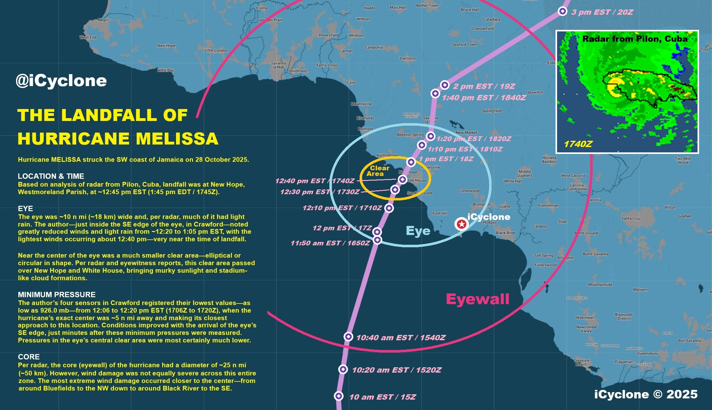
ljmac75 wrote:This is completely random but on one of the icyclone facebook posts (the one with his analysis of the landfall timing) there's a comment thread with some pictures by people who went through the eye, I don't know if there's a way to share a link to some random FB comments but they're there in the replies to a comment with 21 replies. I don't know how to explain this any better. A guy named "Joseph Wright" got a pretty good stadium effect pic.
ncforecaster89 wrote:ljmac75 wrote:This is completely random but on one of the icyclone facebook posts (the one with his analysis of the landfall timing) there's a comment thread with some pictures by people who went through the eye, I don't know if there's a way to share a link to some random FB comments but they're there in the replies to a comment with 21 replies. I don't know how to explain this any better. A guy named "Joseph Wright" got a pretty good stadium effect pic.
Hi Ljmac,
Thank you for sharing those details. Two things quickly come to mind. One, that wouldn’t be at all surprising nor does it have much correlation with these presumed intensity estimates…given we’re talking about a Cat 5 tempest. Secondly, it’s difficult to take such images at face value, nowadays, given AI and people posting images from other storms.
Either way, I’m always going to prioritize the objective meteorological data over things such as eye clarity on the ground or associated damage left in the aftermath of such monsters.
ljmac75 wrote:ncforecaster89 wrote:ljmac75 wrote:This is completely random but on one of the icyclone facebook posts (the one with his analysis of the landfall timing) there's a comment thread with some pictures by people who went through the eye, I don't know if there's a way to share a link to some random FB comments but they're there in the replies to a comment with 21 replies. I don't know how to explain this any better. A guy named "Joseph Wright" got a pretty good stadium effect pic.
Hi Ljmac,
Thank you for sharing those details. Two things quickly come to mind. One, that wouldn’t be at all surprising nor does it have much correlation with these presumed intensity estimates…given we’re talking about a Cat 5 tempest. Secondly, it’s difficult to take such images at face value, nowadays, given AI and people posting images from other storms.
Either way, I’m always going to prioritize the objective meteorological data over things such as eye clarity on the ground or associated damage left in the aftermath of such monsters.
This has nothing to do with the intensity estimate, I just remember people wondering if anyone got some good pictures of the eye on the ground. Maybe that was on a different site.
Users browsing this forum: No registered users and 50 guests