Texas Winter 2025-2026

Winter Weather Discussion

Moderator: S2k Moderators

Forum rules

The posts in this forum are NOT official forecast and should not be used as such. They are just the opinion of the poster and may or may not be backed by sound meteorological data. They are NOT endorsed by any professional institution or STORM2K.

Help Support Storm2K
Message
Author
snownado
Category 5
Category 5
Posts: 1016
Joined: Sat Dec 09, 2023 7:00 pm
Location: Plano, TX

Re: Texas Winter 2025-2026

#3101 Postby snownado » Tue Jan 20, 2026 5:09 pm

txtwister78 wrote:18z GFS trending colder and again advancing the arctic air deeper into Texas faster with your freeze line approaching northern Bexar by midnight Saturday morning dropping from there.


18z GFS is warmer aloft, took a step in the direciton of the EURO.

It would be a massive heartbreaker for DFW too. To go from a 1" in downtown Dallas to nearly 18" in Sherman...
Last edited by snownado on Tue Jan 20, 2026 5:12 pm, edited 3 times in total.
0 likes   

Stratton23
Category 5
Category 5
Posts: 3370
Joined: Fri Jul 21, 2023 10:59 pm
Location: Katy, Tx

Re: Texas Winter 2025-2026

#3102 Postby Stratton23 » Tue Jan 20, 2026 5:10 pm

warm nose is significantly weaker on the 18z GFS, not as bad icing, big sleet storm for central and se texas
4 likes   

User avatar
Texas Snow
S2K Supporter
S2K Supporter
Posts: 804
Joined: Mon Oct 19, 2015 12:06 pm
Location: N. Dallas & Cedar Creek Lake

Re: Texas Winter 2025-2026

#3103 Postby Texas Snow » Tue Jan 20, 2026 5:12 pm

lol at the contradiction of the last 2 posts :lol:
6 likes   
"Don't let wishcastin get in the way of your forecastin"

Image

User avatar
wxman22
Category 5
Category 5
Posts: 1772
Joined: Mon Jan 30, 2006 12:39 am
Location: Wichita Falls, TX
Contact:

Re: Texas Winter 2025-2026

#3104 Postby wxman22 » Tue Jan 20, 2026 5:13 pm

18z GFS Wow!

Image
5 likes   

HockeyTx82
S2K Supporter
S2K Supporter
Posts: 2705
Joined: Tue Oct 27, 2009 11:17 am
Location: Ponder, TX

Re: Texas Winter 2025-2026

#3105 Postby HockeyTx82 » Tue Jan 20, 2026 5:14 pm

Texas Snow wrote:lol at the contradiction of the last 2 posts :lol:


I was trying to make sense of it too.......
1 likes   
Don't hold me accountable for anything I post on this forum. Leave the real forecasting up to the professionals.

Location: Ponder, TX (all observation posts are this location unless otherwise noted)

snownado
Category 5
Category 5
Posts: 1016
Joined: Sat Dec 09, 2023 7:00 pm
Location: Plano, TX

Re: Texas Winter 2025-2026

#3106 Postby snownado » Tue Jan 20, 2026 5:15 pm

Texas Snow wrote:lol at the contradiction of the last 2 posts :lol:


The warm layer isn't as deep (which is good), as it's mainly focused between 800mb and 750mb, but it's still a degree or two warmer + it is slower to break down.

Translates to mostly a sleet fest for DFW while the Red River counties are bured in a foot and a half of snow (Ugh!l).
1 likes   

HockeyTx82
S2K Supporter
S2K Supporter
Posts: 2705
Joined: Tue Oct 27, 2009 11:17 am
Location: Ponder, TX

Re: Texas Winter 2025-2026

#3107 Postby HockeyTx82 » Tue Jan 20, 2026 5:16 pm

Model “Wheelhouse” Cheat Sheet — GFS vs Euro vs NAM

- ECMWF (Euro)
- Most accurate Days 3–7
- Best for storm tracks, large‑scale patterns, winter setups
- Loses accuracy after Day 8–10
- Not the best for short‑range local details

- GFS
- Most reliable Days 1–5
- Good for big‑picture trends and temperature patterns
- Starts wobbling after Day 6
- Known for flip‑flops and overdoing QPF/snow

- NAM
- Strongest 0–48 hours
- Great for precipitation type and mesoscale winter details
- Accuracy drops fast after 60 hours
2 likes   
Don't hold me accountable for anything I post on this forum. Leave the real forecasting up to the professionals.

Location: Ponder, TX (all observation posts are this location unless otherwise noted)

User avatar
Ntxw
Storm2k Moderator
Storm2k Moderator
Posts: 23301
Joined: Wed Oct 21, 2009 6:34 pm
Location: DFW, Texas

Re: Texas Winter 2025-2026

#3108 Postby Ntxw » Tue Jan 20, 2026 5:16 pm

Be in the bullseye 24 hours out, not before! The curse!
4 likes   
The above post and any post by Ntxw is NOT an official forecast and should not be used as such. It is just the opinion of the poster and may or may not be backed by sound meteorological data. It is NOT endorsed by any professional institution including Storm2k. For official information, please refer to NWS products.

  Help support Storm2K!
Help Support Storm2K

Gotwood
Category 2
Category 2
Posts: 701
Joined: Wed Dec 14, 2022 7:18 pm
Location: Brock Tx

Re: Texas Winter 2025-2026

#3109 Postby Gotwood » Tue Jan 20, 2026 5:17 pm


Crazy the difference in Freezing rain totals from the GFS and the Euro.
0 likes   

snownado
Category 5
Category 5
Posts: 1016
Joined: Sat Dec 09, 2023 7:00 pm
Location: Plano, TX

Re: Texas Winter 2025-2026

#3110 Postby snownado » Tue Jan 20, 2026 5:18 pm

snownado wrote:
Texas Snow wrote:lol at the contradiction of the last 2 posts :lol:


The warm layer isn't as deep (which is good), as it's mainly focused between 800mb and 750mb, but it's still a degree or two warmer + it is slower to break down.

Translates to mostly a sleet fest for DFW while the Red River counties are bured in a foot and a half of snow (Ugh!l).


^^^And I'm going to be cheering on Summer torches for eternity if that happens (Ouija boards, witchcraft, black magic and all).

That would be enough to break me...
1 likes   

User avatar
Haris
Category 5
Category 5
Posts: 1813
Joined: Mon Nov 27, 2017 8:19 pm
Location: ( Bee Cave) West Austin, Texas

Re: Texas Winter 2025-2026

#3111 Postby Haris » Tue Jan 20, 2026 5:18 pm

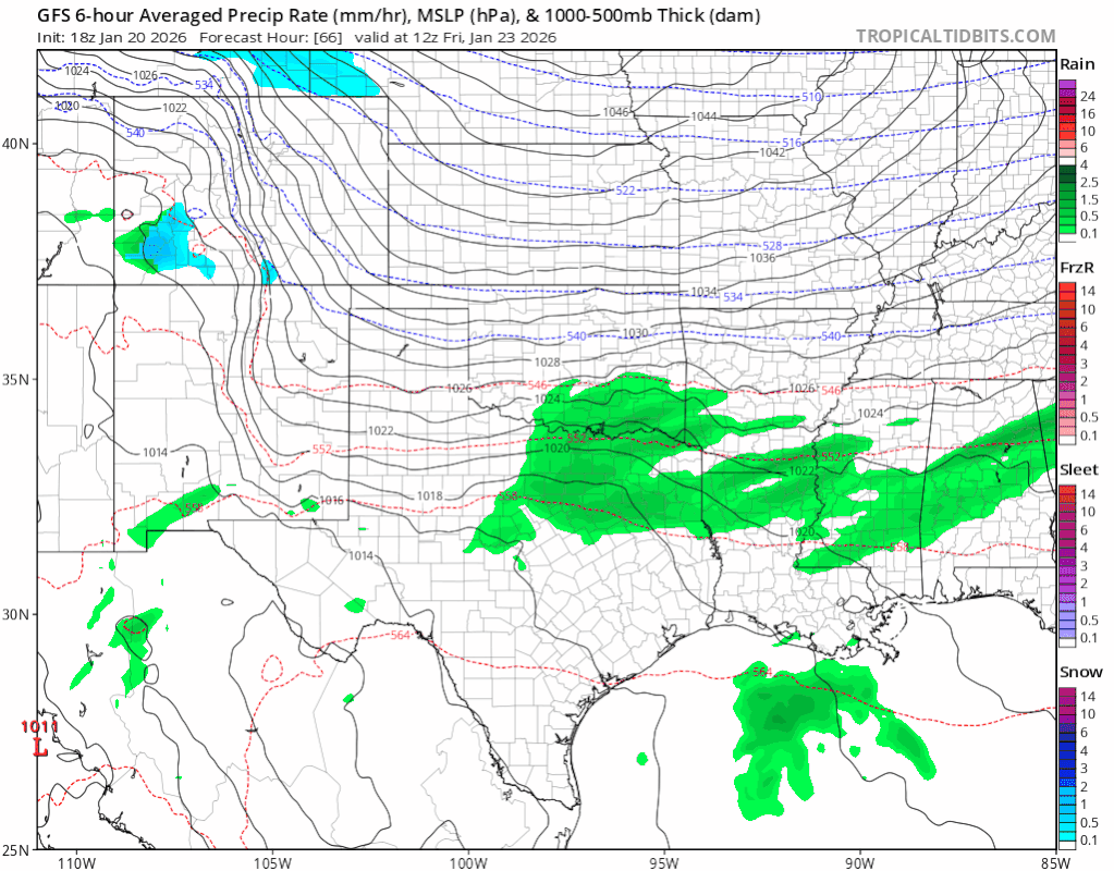
From what I interpret, chance of seeing frozen precipitation falling from the sky is 100% north of i10 at this point. The question is banding, and ptypes and that has more to do with the phasing (if) of the low and where/when that happens. A slower elongated track will allow the lower levels to cool enough to bring snowflakes anywhere from Oklahoma to Austin by Sat/night/Sun , with light freezing rain and sleet before. Totals in this scenario for snow across NTX would be near 3-7" IMO..

However, a faster phased low near NM with a neg tilt would allow heavier freezingrain/sleet for most of Texas N of i10, and less snow except maybe briefly between Waco and Red River Sat Night/ early Sunday. Maybe 1-3" if you are lucky. Either way, get ready!!
2 likes   
Weather geek and a storm spotter in West Austin. Not a degreed meteorologist. Big snow fan. Love rain and cold! Despise heat!

rwfromkansas
Category 5
Category 5
Posts: 2879
Joined: Sat Aug 27, 2005 12:47 am
Location: North Fort Worth

Re: Texas Winter 2025-2026

#3112 Postby rwfromkansas » Tue Jan 20, 2026 5:20 pm

Ntxw wrote:Don't see a forecast like this everyday around these parts. Remember we went a quarter century without a single digit temp up until 2021?

DFW
Friday: Rain showers likely before noon, then rain showers, possibly mixed with sleet. Temperature falling to around 33 by 4pm. Northeast wind 10 to 15 mph, with gusts as high as 25 mph. Chance of precipitation is 80%.

Friday Night: Rain showers, freezing rain, and sleet before midnight, then sleet, possibly mixed with freezing rain. The sleet could be heavy at times. Low around 20. Northeast wind 10 to 15 mph, with gusts as high as 20 mph. Chance of precipitation is 90%.

Saturday: Sleet, possibly mixed with snow showers and freezing rain. The sleet could be heavy at times. High near 25. North wind around 15 mph, with gusts as high as 25 mph. Chance of precipitation is 90%.

Saturday Night: A chance of snow showers, freezing rain, and sleet. Mostly cloudy, with a low around 12. North wind around 10 mph, with gusts as high as 20 mph. Chance of precipitation is 40%.

Sunday: Partly sunny and cold, with a high near 25.

Sunday Night: Partly cloudy, with a low around 9.

Monday: Sunny, with a high near 32.

Monday Night: Partly cloudy, with a low around 18.


It's like they don't take into account the sleet and snow with their high temperature on Monday. I could see upper 20s, but 32?
0 likes   

rwfromkansas
Category 5
Category 5
Posts: 2879
Joined: Sat Aug 27, 2005 12:47 am
Location: North Fort Worth

Re: Texas Winter 2025-2026

#3113 Postby rwfromkansas » Tue Jan 20, 2026 5:24 pm

snownado wrote:
txtwister78 wrote:18z GFS trending colder and again advancing the arctic air deeper into Texas faster with your freeze line approaching northern Bexar by midnight Saturday morning dropping from there.


18z GFS is warmer aloft, took a step in the direciton of the EURO.

It would be a massive heartbreaker for DFW too. To go from a 1" in downtown Dallas to nearly 18" in Sherman...


It there's a foot of snow an hour away, I can just drive there once the roads are good. Lol.
0 likes   

User avatar
txtwister78
Category 5
Category 5
Posts: 2060
Joined: Wed Jan 30, 2019 12:56 pm
Location: San Antonio

Re: Texas Winter 2025-2026

#3114 Postby txtwister78 » Tue Jan 20, 2026 5:24 pm

snownado wrote:
txtwister78 wrote:18z GFS trending colder and again advancing the arctic air deeper into Texas faster with your freeze line approaching northern Bexar by midnight Saturday morning dropping from there.


18z GFS is warmer aloft, took a step in the direciton of the EURO.

It would be a massive heartbreaker for DFW too. To go from a 1" in downtown Dallas to nearly 18" in Sherman...


Surface temps I'm referring to but I wouldn't worry about specifics just yet in terms of precip types up in that region until we get into high-resolution range anyway.
1 likes   

User avatar
Ntxw
Storm2k Moderator
Storm2k Moderator
Posts: 23301
Joined: Wed Oct 21, 2009 6:34 pm
Location: DFW, Texas

Re: Texas Winter 2025-2026

#3115 Postby Ntxw » Tue Jan 20, 2026 5:24 pm

rwfromkansas wrote:It's like they don't take into account the sleet and snow with their high temperature on Monday. I could see upper 20s, but 32?


Just from observation, NWS tends to follow MOS guidance a bit so there is a little climo involved. GFS MOS actually has upper 20s in the latest rendition so it's possible they will go colder in future forecast for the later period.

It's possible this is a 80-90+ hours at or below freezing period for the metroplex.
4 likes   
The above post and any post by Ntxw is NOT an official forecast and should not be used as such. It is just the opinion of the poster and may or may not be backed by sound meteorological data. It is NOT endorsed by any professional institution including Storm2k. For official information, please refer to NWS products.


  Help support Storm2K!

Help Support Storm2K


gpsnowman
S2K Supporter
S2K Supporter
Posts: 3287
Joined: Fri Jan 07, 2011 10:35 am
Location: Grand Prairie Tx

Re: Texas Winter 2025-2026

#3116 Postby gpsnowman » Tue Jan 20, 2026 5:26 pm

I do believe we will get a fair amount of sleet followed by a fair amount of snow as the system takes its time exiting the state on Sunday. Would love another footer like 2010 but a lot of sleet will cut into the snow totals. Either way a winter wonderland is coming!!
Last edited by gpsnowman on Tue Jan 20, 2026 5:31 pm, edited 2 times in total.
2 likes   

bohaiboy
Tropical Depression
Tropical Depression
Posts: 87
Joined: Sat Aug 09, 2008 11:20 am

Re: Texas Winter 2025-2026

#3117 Postby bohaiboy » Tue Jan 20, 2026 5:28 pm

All talk about precip, but there are some brutally cold temps forecast as well. For us in Texas Hill Country, 50 miles NW of San Antonio, TWC is predicting 10F. That's only 8 degrees warmer than Snowmageddon in 2021. Filling up spare water sources in case we lose power, which means we lose water also as our subdivision in on a well water system with no backup generator.
Last edited by bohaiboy on Tue Jan 20, 2026 5:29 pm, edited 1 time in total.
0 likes   
TW in Texas Hill Country :flag:

rwfromkansas
Category 5
Category 5
Posts: 2879
Joined: Sat Aug 27, 2005 12:47 am
Location: North Fort Worth

Re: Texas Winter 2025-2026

#3118 Postby rwfromkansas » Tue Jan 20, 2026 5:28 pm

HockeyTx82 wrote:Model “Wheelhouse” Cheat Sheet — GFS vs Euro vs NAM

- ECMWF (Euro)
- Most accurate Days 3–7
- Best for storm tracks, large‑scale patterns, winter setups
- Loses accuracy after Day 8–10
- Not the best for short‑range local details

- GFS
- Most reliable Days 1–5
- Good for big‑picture trends and temperature patterns
- Starts wobbling after Day 6
- Known for flip‑flops and overdoing QPF/snow

- NAM
- Strongest 0–48 hours
- Great for precipitation type and mesoscale winter details
- Accuracy drops fast after 60 hours


I wish there was a save post option on here. Lol. This would be helpful. I can save it as a bookmark I guess. On the GFS I still see a decent period where it is snow for DFW.
2 likes   

HockeyTx82
S2K Supporter
S2K Supporter
Posts: 2705
Joined: Tue Oct 27, 2009 11:17 am
Location: Ponder, TX

Re: Texas Winter 2025-2026

#3119 Postby HockeyTx82 » Tue Jan 20, 2026 5:32 pm

rwfromkansas wrote:
HockeyTx82 wrote:Model “Wheelhouse” Cheat Sheet — GFS vs Euro vs NAM

- ECMWF (Euro)
- Most accurate Days 3–7
- Best for storm tracks, large‑scale patterns, winter setups
- Loses accuracy after Day 8–10
- Not the best for short‑range local details

- GFS
- Most reliable Days 1–5
- Good for big‑picture trends and temperature patterns
- Starts wobbling after Day 6
- Known for flip‑flops and overdoing QPF/snow

- NAM
- Strongest 0–48 hours
- Great for precipitation type and mesoscale winter details
- Accuracy drops fast after 60 hours


I wish there was a save post option on here. Lol. This would be helpful. I can save it as a bookmark I guess. On the GFS I still see a decent period where it is snow for DFW.


Well this was a quick copilot AI search, so take it with a grain of salt, unless a professional wants to chime in and say yep that's valid.
1 likes   
Don't hold me accountable for anything I post on this forum. Leave the real forecasting up to the professionals.

Location: Ponder, TX (all observation posts are this location unless otherwise noted)

orangeblood
S2K Supporter
S2K Supporter
Posts: 3816
Joined: Tue Dec 15, 2009 6:14 pm
Location: Fort Worth, TX

Re: Texas Winter 2025-2026

#3120 Postby orangeblood » Tue Jan 20, 2026 5:33 pm

gpsnowman wrote:I do believe we will get a fair amount of sleet followed by a fair amount of snow as the system takes its time exiting the state on Sunday. Would love another footer like 2010 but a lot of sleet will cut into the snow totals. Either way a winter wonderland is coming!!


Agreed, majority sleet Friday night into Saturday then transition to all snow Saturday afternoon thru Sunday morning as ULL moves across. Also, NWS will likely extend Warmings into Sunday with these trends
6 likes   


Return to “Winter Weather”