Texas Winter 2025-2026

Winter Weather Discussion

Moderator: S2k Moderators

Forum rules

The posts in this forum are NOT official forecast and should not be used as such. They are just the opinion of the poster and may or may not be backed by sound meteorological data. They are NOT endorsed by any professional institution or STORM2K.

Help Support Storm2K
Message
Author
User avatar
txtwister78
Category 5
Category 5
Posts: 2072
Joined: Wed Jan 30, 2019 12:56 pm
Location: San Antonio

Re: Texas Winter 2025-2026

#4061 Postby txtwister78 » Thu Jan 22, 2026 9:39 pm

LearnedHat wrote:
txtwister78 wrote:As I've been highlighting for the past few days this makes all the difference in terms of impacts for folks further south in particular regarding the potential for higher ice accumulations and so very important to keep tabs on this as I think the NWS offices further south along with local media in my area in particular may be playing a little catch up with this reality.

Arctic air especially when you're talking about a 1052 high centered across the midwest is going to push and arrive much faster. Just seen it far too many times and so globals (in particular Euro which many within media use) are not as helpful across the south when it comes to surface temps/shallow arctic air.

Below you can see already the comparison between the HRRR and Euro temps at 6PM Saturday. My guess is the HRRR will continue to trend colder by then in future runs in addition to other short range guidance such as the WRF-NSSL and ARW.

https://images.weatherbell.com/model/hrrr/austin/t2m_f/1769126400/1769299200-7Xm5MCKlpYw.png

https://images.weatherbell.com/model/ecmwf-deterministic/austin/t2m_f/1769104800/1769299200-jLboTTQ9Nmc.png


I am Where’s Waldo-ing the crap out of that but having trouble spotting the difference.


Surface temps are about 5-6 degrees colder on the HRRR at 6pm compared to the Euro and clearly below freezing in the southern HC meaning more time for ice to accumulate. I expect that trend to continue in future extended runs.
3 likes   

TomballEd
Category 5
Category 5
Posts: 1180
Age: 62
Joined: Wed Aug 16, 2023 4:52 pm
Location: Spring/Klein area, not Tomball

Re: Texas Winter 2025-2026

#4062 Postby TomballEd » Thu Jan 22, 2026 9:40 pm

Texas Snow wrote:
ATXAG95 wrote:
I am trying to decide if I should keep my husband home on Saturday afternoon to watch the Aggies play basketball rather than watch from our seats in Reed Arena.


Probably depends on where you live. If in College Station or south it’s probably ok. It’s not forecast to drop to freezing there until 10pm Saturday night. (According to NWS point forecast). Of course check the NWS as we get closer.

Yell loud!


I think Alabama is playing Tennessee, they won a court injunction for someone who has had 3 different NBA contracts to play. NIL is bad, Alabama is worse. I hope they forfeit every game this guy plays in.

Back in SETX, I've seen the HRRR, Euro might be a degree or two warm in Houston, but precip ends long before freezing air arrives. Not a forecast bust for HGX here, they know what is almost certain to happen, they are just erring on the side of caution. I don't think CLL changes to light freezing rain until after midnight,
1 likes   

User avatar
txtwister78
Category 5
Category 5
Posts: 2072
Joined: Wed Jan 30, 2019 12:56 pm
Location: San Antonio

Re: Texas Winter 2025-2026

#4063 Postby txtwister78 » Thu Jan 22, 2026 9:43 pm

TomballEd wrote:
Texas Snow wrote:
ATXAG95 wrote:
I am trying to decide if I should keep my husband home on Saturday afternoon to watch the Aggies play basketball rather than watch from our seats in Reed Arena.


Probably depends on where you live. If in College Station or south it’s probably ok. It’s not forecast to drop to freezing there until 10pm Saturday night. (According to NWS point forecast). Of course check the NWS as we get closer.

Yell loud!


I think Alabama is playing Tennessee, they won a court injunction for someone who has had 3 different NBA contracts to play. NIL is bad, Alabama is worse. I hope they forfeit every game this guy plays in.

Back in SETX, I've seen the HRRR, Euro might be a degree or two warm in Houston, but precip ends long before freezing air arrives. Not a forecast bust for HGX here, they know what is almost certain to happen, they are just erring on the side of caution. I don't think CLL changes to light freezing rain until after midnight,


It will take a little longer for the arctic air to spill into SE TX due to the shadow effect that as discussed a few days ago clearly shows up on models.
0 likes   

User avatar
CaptinCrunch
S2K Supporter
S2K Supporter
Posts: 8766
Age: 57
Joined: Mon Nov 03, 2003 4:33 pm
Location: Kennedale, TX (Tarrant Co.)

Re: Texas Winter 2025-2026

#4064 Postby CaptinCrunch » Thu Jan 22, 2026 9:48 pm

jasons2k wrote:The freezing line is now in the NW Texas panhandle.


I have to disagree as to were the surface front is actually located. The front is just south or a line from Topeka KS to Lincoln KS. The dew points will drop to single digits in the cold dry air, plus the winds are pretty gusty with the front as it moves through.

Lincoln KS 30F

Humidity 40%
Wind Speed NE 23 G 28 mph
Barometer 30.27 in
Dewpoint 9°F (-13°C)
Visibility 10.00 mi
Wind Chill 17°F (-8°C)
Last update 22 Jan 8:35 pm CST

Topeka KS 30F

Humidity 41%
Wind Speed N 14 mph
Barometer 30.31 in (1027.6 mb)
Dewpoint 9°F (-13°C)
Visibility 10.00 mi
Wind Chill 19°F (-7°C)
Last update 22 Jan 7:53 pm CST

Tulsa OK 47F

Humidity 36%
Wind Speed SE 3 mph
Barometer 30.16 in (1021.5 mb)
Dewpoint 21°F (-6°C)
Visibility 10.00 mi
Last update 22 Jan 7:53 pm CST

Gage OK 39F

Humidity 82%
Wind Speed S 7 mph
Barometer 30.08 in (1019.7 mb)
Dewpoint 34°F (1°C)
Visibility 10.00 mi
Wind Chill 34°F (1°C)
Last update 22 Jan 7:53 pm CST

Dalhart TX 37F Topography

Humidity 46%
Wind Speed NE 12 mph
Barometer 30.06 in (1018.3 mb)
Dewpoint 18°F (-8°C)
Visibility 10.00 mi
Wind Chill 29°F (-2°C)
Last update 22 Jan 7:53 pm CST
Last edited by CaptinCrunch on Thu Jan 22, 2026 9:54 pm, edited 1 time in total.
1 likes   

User avatar
jasons2k
Storm2k Executive
Storm2k Executive
Posts: 8264
Age: 52
Joined: Wed Jul 06, 2005 12:32 pm
Location: The Woodlands, TX

Re: Texas Winter 2025-2026

#4065 Postby jasons2k » Thu Jan 22, 2026 9:53 pm

CaptinCrunch wrote:
jasons2k wrote:The freezing line is now in the NW Texas panhandle.


I have to disagree as to were the surface front is actually located. The front is just south or a line from Topeka KS to Lincoln KS.

Lincoln KS 30F

Humidity 40%
Wind Speed NE 23 G 28 mph
Barometer 30.27 in
Dewpoint 9°F (-13°C)
Visibility 10.00 mi
Wind Chill 17°F (-8°C)
Last update 22 Jan 8:35 pm CST

Topeka KS 30F

Humidity 41%
Wind Speed N 14 mph
Barometer 30.31 in (1027.6 mb)
Dewpoint 9°F (-13°C)
Visibility 10.00 mi
Wind Chill 19°F (-7°C)
Last update 22 Jan 7:53 pm CST

Tulsa OK 47F

Humidity 36%
Wind Speed SE 3 mph
Barometer 30.16 in (1021.5 mb)
Dewpoint 21°F (-6°C)
Visibility 10.00 mi
Last update 22 Jan 7:53 pm CST

Gage OK 39F

Humidity 82%
Wind Speed S 7 mph
Barometer 30.08 in (1019.7 mb)
Dewpoint 34°F (1°C)
Visibility 10.00 mi
Wind Chill 34°F (1°C)
Last update 22 Jan 7:53 pm CST

Dalhart TX 37F Topography

Humidity 46%
Wind Speed NE 12 mph
Barometer 30.06 in (1018.3 mb)
Dewpoint 18°F (-8°C)
Visibility 10.00 mi
Wind Chill 29°F (-2°C)
Last update 22 Jan 7:53 pm CST

It’s 30 in Stratford, 27 near Texline, and 24 in Clayton, NM.

Llano Estacado.
4 likes   

User avatar
txtwister78
Category 5
Category 5
Posts: 2072
Joined: Wed Jan 30, 2019 12:56 pm
Location: San Antonio

Re: Texas Winter 2025-2026

#4066 Postby txtwister78 » Thu Jan 22, 2026 10:02 pm

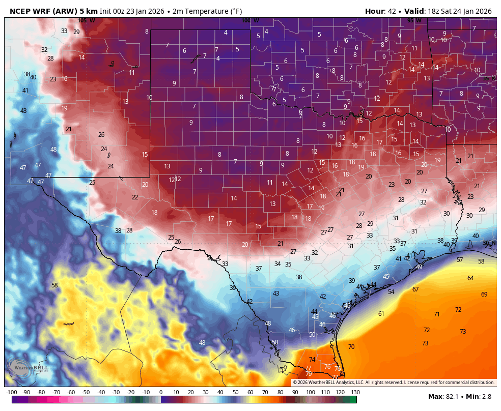
0z WRF-ARW is in and as just mentioned another example and this is noon Saturday folks. Not even close to what Euro or GFS for that matter has progged for surface temps.

Image
5 likes   

HockeyTx82
S2K Supporter
S2K Supporter
Posts: 2725
Joined: Tue Oct 27, 2009 11:17 am
Location: Ponder, TX

Re: Texas Winter 2025-2026

#4067 Postby HockeyTx82 » Thu Jan 22, 2026 10:06 pm

txtwister78 wrote:0z WRF-ARW is in and as just mentioned another example and this is noon Saturday folks. Not even close to what Euro or GFS for that matter has progged for surface temps.

https://images.weatherbell.com/model/ncep-wrf-arw-conus/tx/t2m_f/1769126400/1769277600-a7m9QZ0DB5M.png


Looks like Wxman57 needs to head to Brownsville.
2 likes   
Don't hold me accountable for anything I post on this forum. Leave the real forecasting up to the professionals.

Location: Ponder, TX (all observation posts are this location unless otherwise noted)

User avatar
wxman22
Category 5
Category 5
Posts: 1787
Joined: Mon Jan 30, 2006 12:39 am
Location: Wichita Falls, TX
Contact:

Re: Texas Winter 2025-2026

#4068 Postby wxman22 » Thu Jan 22, 2026 10:06 pm

3K NAM

Image
0 likes   

User avatar
Longhornmaniac8
Category 1
Category 1
Posts: 257
Joined: Thu Nov 18, 2010 2:30 am
Location: Austin, TX

Re: Texas Winter 2025-2026

#4069 Postby Longhornmaniac8 » Thu Jan 22, 2026 10:11 pm

Not surprisingly, it looks like some of the higher resolution models are initializing colder and handling these airmasses better than we know the global models do. My question is, does this "extra" cold, should it verify, apply only to the lowest levels of the air column (say 1000-850) or is the entire airmass colder?

And if it were to be, say, 5 degrees colder than the GFS or Euro are currently showing, would that lead to a quicker changeover to sleet due to the larger sub-freezing layer? Implicit within that assumption is that it would mean freezing rain would also begin earlier due to the sub-freezing surface temps arriving sooner, so I'm not necessarily asking whether we'd have less freezing rain but rather would sleet begin sooner?
Last edited by Longhornmaniac8 on Thu Jan 22, 2026 10:15 pm, edited 1 time in total.
0 likes   

User avatar
Quixotic
Category 3
Category 3
Posts: 864
Joined: Tue Feb 14, 2017 12:27 am
Location: Frisco

Re: Texas Winter 2025-2026

#4070 Postby Quixotic » Thu Jan 22, 2026 10:13 pm

DallasAg wrote:
Quixotic wrote:I’m leaning more Dec 2013 than Feb 2011. 2013 was a shorter event. 2011 we had thunder sleet initially, a 24 hour pause and then the 4-6” snow thump. This time it looks like a 36 hour event with mostly sleet with a 2” snow thump. 2011 was like maybe an 1” of sleet/ice. Completely undriveable. Once the snow hit traction was available however my front fender was plowing through snow in curb drifts. Either way, it’s better than 85 degree Christmas.

This setup reminds me a lot of the event we had March 4-5, 1989. Arctic front blew through early morning hours of the 4th. We had several rounds of sleet, including some thunder sleet, that lasted through mid-afternoon. Then a lull in the action until late night on the 4th/5th when another round came through with some heavier sleet that changed to a pretty decent snow. I don't think that storm had the size and heft of this one in terms of regional scope though.


Yeah. I remember that one. Did a lot of sledding on cardboard on that one. Think this one will be heavier.
0 likes   

BradKingK
Tropical Low
Tropical Low
Posts: 26
Joined: Wed Feb 01, 2023 3:25 pm
Location: Tyler, TX

Re: Texas Winter 2025-2026

#4071 Postby BradKingK » Thu Jan 22, 2026 10:14 pm

txtwister78 wrote:0z WRF-ARW is in and as just mentioned another example and this is noon Saturday folks. Not even close to what Euro or GFS for that matter has progged for surface temps.


Maybe share the comparative data so we don't have to track it down? That would be appreciated.
0 likes   

User avatar
bubba hotep
S2K Supporter
S2K Supporter
Posts: 5932
Joined: Wed Dec 28, 2016 1:00 am
Location: Collin County Texas

Re: Texas Winter 2025-2026

#4072 Postby bubba hotep » Thu Jan 22, 2026 10:16 pm

00z ICON

Image
2 likes   
Winter time post are almost exclusively focused on the DFW area.

User avatar
Iceresistance
Category 5
Category 5
Posts: 9520
Age: 22
Joined: Sat Oct 10, 2020 9:45 am
Location: Tecumseh, OK/Norman, OK

Re: Texas Winter 2025-2026

#4073 Postby Iceresistance » Thu Jan 22, 2026 10:18 pm

I don't remember the last time the NBM was this aggressive :eek: :eek: :eek:

Image
https://s12.gifyu.com/images/bk3zY.gif
1 likes   
Bill 2015 & Beta 2020

Winter 2020-2021 :cold:

All observations are in Tecumseh, OK unless otherwise noted.

Winter posts are focused mainly for Oklahoma & Texas.

Take any of my forecasts with a grain of salt, refer to the NWS, SPC, and NHC for official information

Never say Never with weather! Because ANYTHING is possible!

Captmorg70
Tropical Storm
Tropical Storm
Posts: 185
Age: 38
Joined: Mon Dec 18, 2017 12:07 am
Location: Ponder Tx

Re: Texas Winter 2025-2026

#4074 Postby Captmorg70 » Thu Jan 22, 2026 10:20 pm


The ICON doesn’t show sleet correct? That’s the best it’s looked for DFW
0 likes   

User avatar
wxman22
Category 5
Category 5
Posts: 1787
Joined: Mon Jan 30, 2006 12:39 am
Location: Wichita Falls, TX
Contact:

Re: Texas Winter 2025-2026

#4075 Postby wxman22 » Thu Jan 22, 2026 10:22 pm

0z WRF models, the freezing line is much further south than other models.

Image
Image
2 likes   

User avatar
Ntxw
Storm2k Moderator
Storm2k Moderator
Posts: 23333
Joined: Wed Oct 21, 2009 6:34 pm
Location: DFW, Texas

Re: Texas Winter 2025-2026

#4076 Postby Ntxw » Thu Jan 22, 2026 10:24 pm

I get it warm nose is a warm nose but man, I just don't recall seeing 10-18F and a warm nose preventing snow. That's just insane.
6 likes   
The above post and any post by Ntxw is NOT an official forecast and should not be used as such. It is just the opinion of the poster and may or may not be backed by sound meteorological data. It is NOT endorsed by any professional institution including Storm2k. For official information, please refer to NWS products.

  Help support Storm2K!
Help Support Storm2K

Captmorg70
Tropical Storm
Tropical Storm
Posts: 185
Age: 38
Joined: Mon Dec 18, 2017 12:07 am
Location: Ponder Tx

Re: Texas Winter 2025-2026

#4077 Postby Captmorg70 » Thu Jan 22, 2026 10:26 pm

Ntxw wrote:I get it warm nose is a warm nose but man, I just don't recall seeing 10-18F and a warm nose preventing snow. That's just insane.


Feel the same way. My brain honestly can’t comprehend it.
3 likes   

Snowman67
Category 2
Category 2
Posts: 646
Joined: Thu Dec 31, 2009 12:44 pm
Location: Tomball, TX

Re: Texas Winter 2025-2026

#4078 Postby Snowman67 » Thu Jan 22, 2026 10:30 pm

jasons2k wrote:
CaptinCrunch wrote:
jasons2k wrote:The freezing line is now in the NW Texas panhandle.


I have to disagree as to were the surface front is actually located. The front is just south or a line from Topeka KS to Lincoln KS.

Lincoln KS 30F

Humidity 40%
Wind Speed NE 23 G 28 mph
Barometer 30.27 in
Dewpoint 9°F (-13°C)
Visibility 10.00 mi
Wind Chill 17°F (-8°C)
Last update 22 Jan 8:35 pm CST

Topeka KS 30F

Humidity 41%
Wind Speed N 14 mph
Barometer 30.31 in (1027.6 mb)
Dewpoint 9°F (-13°C)
Visibility 10.00 mi
Wind Chill 19°F (-7°C)
Last update 22 Jan 7:53 pm CST

Tulsa OK 47F

Humidity 36%
Wind Speed SE 3 mph
Barometer 30.16 in (1021.5 mb)
Dewpoint 21°F (-6°C)
Visibility 10.00 mi
Last update 22 Jan 7:53 pm CST

Gage OK 39F

Humidity 82%
Wind Speed S 7 mph
Barometer 30.08 in (1019.7 mb)
Dewpoint 34°F (1°C)
Visibility 10.00 mi
Wind Chill 34°F (1°C)
Last update 22 Jan 7:53 pm CST

Dalhart TX 37F Topography

Humidity 46%
Wind Speed NE 12 mph
Barometer 30.06 in (1018.3 mb)
Dewpoint 18°F (-8°C)
Visibility 10.00 mi
Wind Chill 29°F (-2°C)
Last update 22 Jan 7:53 pm CST

It’s 30 in Stratford, 27 near Texline, and 24 in Clayton, NM.

Llano Estacado.


Dalhart weather station reporting 32F on Weather Underground.
1 likes   
Any forecast I make is based on my opinion only. Please refer to the NWS or NHC for official forecasts.

User avatar
Iceresistance
Category 5
Category 5
Posts: 9520
Age: 22
Joined: Sat Oct 10, 2020 9:45 am
Location: Tecumseh, OK/Norman, OK

Re: Texas Winter 2025-2026

#4079 Postby Iceresistance » Thu Jan 22, 2026 10:32 pm

I know the RRFS is an experimental model, but I don't remember seeing 30+ inches of snow from a single storm for Oklahoma.
Image
https://s12.gifyu.com/images/bk3Mq.png
0 likes   
Bill 2015 & Beta 2020

Winter 2020-2021 :cold:

All observations are in Tecumseh, OK unless otherwise noted.

Winter posts are focused mainly for Oklahoma & Texas.

Take any of my forecasts with a grain of salt, refer to the NWS, SPC, and NHC for official information

Never say Never with weather! Because ANYTHING is possible!

User avatar
txtwister78
Category 5
Category 5
Posts: 2072
Joined: Wed Jan 30, 2019 12:56 pm
Location: San Antonio

Re: Texas Winter 2025-2026

#4080 Postby txtwister78 » Thu Jan 22, 2026 10:33 pm

BradKingK wrote:
txtwister78 wrote:0z WRF-ARW is in and as just mentioned another example and this is noon Saturday folks. Not even close to what Euro or GFS for that matter has progged for surface temps.


Maybe share the comparative data so we don't have to track it down? That would be appreciated.


I did. Go back a page and look at my post regarding what the Euro has progged for surface temps compared to the HRRR and the ARW in particular but this is all public available information that you can also readily track on tropical tidbits or Pivotal Weather.
1 likes   


Return to “Winter Weather”