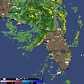
Frances still looks very well organized as she marches across Florida.
I would NOT be surprised if she reintensifies into at least a 90 mph hurricane after she exits the GOM before making landfall again.
http://adds.aviationweather.gov/satelli ... &itype=vis
France still VERY well organized
Moderator: S2k Moderators
Forum rules

The posts in this forum are NOT official forecasts and should not be used as such. They are just the opinion of the poster and may or may not be backed by sound meteorological data. They are NOT endorsed by any professional institution or STORM2K. For official information, please refer to products from the National Hurricane Center and National Weather Service.
-
Stormcenter
- S2K Supporter

- Posts: 6687
- Joined: Wed Sep 03, 2003 11:27 am
- Location: Houston, TX
France still VERY well organized
Last edited by Stormcenter on Sun Sep 05, 2004 12:29 pm, edited 1 time in total.
0 likes

-
Opal storm
-
Anonymous


-
wxman57

- Moderator-Pro Met

- Posts: 23153
- Age: 68
- Joined: Sat Jun 21, 2003 8:06 pm
- Location: Houston, TX (southwest)
Frances appears to be weakening rather quickly now, though its TS winds are expanding outward. With the current NW motion, only about half the circulation (if that much) will emerge into the extreme NE Gulf tonight. If that's the case, then Frances should be a strong TS for the 12hr period (or less) that it skirts the NE Gulf. I've been monitoring Florida obs closely and can't find any reports of hurricane-force winds inland. I suspect there are still a few pockets of hurricane-force winds in some of the heavier squalls, but Frances should weaken to a TS within the next 6 hours.
0 likes
-
Anonymous
-
Stormcenter
- S2K Supporter
- Posts: 6687
- Joined: Wed Sep 03, 2003 11:27 am
- Location: Houston, TX
-
caneman
Stormcenter wrote:Houstoner wrote:Despite the weakening, it still sure had a great look on satellite.
Yes I agree!!!!
I don't know if this is true or not but the Fox National Weather guy said it could actually start to intensify over land as it taps the warm Gulf waters. Any truth to this? We are concerned on the coast of Tampa as that as soon as it hits water it will blow up and give us a good backlash.
0 likes
-
Stormcenter
- S2K Supporter
- Posts: 6687
- Joined: Wed Sep 03, 2003 11:27 am
- Location: Houston, TX
caneman wrote:Stormcenter wrote:Houstoner wrote:Despite the weakening, it still sure had a great look on satellite.
Yes I agree!!!!
I don't know if this is true or not but the Fox National Weather guy said it could actually start to intensify over land as it taps the warm Gulf waters. Any truth to this? We are concerned on the coast of Tampa as that as soon as it hits water it will blow up and give us a good backlash.
Isn't that what Gaston did?
0 likes
-
Stormcenter
- S2K Supporter
- Posts: 6687
- Joined: Wed Sep 03, 2003 11:27 am
- Location: Houston, TX
wxman57 wrote:Frances appears to be weakening rather quickly now, though its TS winds are expanding outward. With the current NW motion, only about half the circulation (if that much) will emerge into the extreme NE Gulf tonight. If that's the case, then Frances should be a strong TS for the 12hr period (or less) that it skirts the NE Gulf. I've been monitoring Florida obs closely and can't find any reports of hurricane-force winds inland. I suspect there are still a few pockets of hurricane-force winds in some of the heavier squalls, but Frances should weaken to a TS within the next 6 hours.
Actually moving wnw at 9mph. I think she will come out further south than the NHC has her coming out. I also still think she will be a hurricane
when she makes a second landfall.
0 likes
-
Cookiely

- S2K Supporter
- Posts: 3211
- Age: 75
- Joined: Fri Aug 13, 2004 7:31 am
- Location: Tampa, Florida
Stormcenter wrote:wxman57 wrote:Frances appears to be weakening rather quickly now, though its TS winds are expanding outward. With the current NW motion, only about half the circulation (if that much) will emerge into the extreme NE Gulf tonight. If that's the case, then Frances should be a strong TS for the 12hr period (or less) that it skirts the NE Gulf. I've been monitoring Florida obs closely and can't find any reports of hurricane-force winds inland. I suspect there are still a few pockets of hurricane-force winds in some of the heavier squalls, but Frances should weaken to a TS within the next 6 hours.
Actually moving wnw at 9mph. I think she will come out further south than the NHC has her coming out. I also still think she will be a hurricane
when she makes a second landfall.
I agree on the track and I think the likely hood of a backlash is significant in light of the fact Frances "the slug" likes to stall over the water.
0 likes
-
Storminole
- Tropical Depression

- Posts: 70
- Age: 64
- Joined: Wed Aug 11, 2004 5:53 pm
- Location: Tallahassee, FL
Who is online
Users browsing this forum: No registered users and 62 guests