 The posts in this forum are NOT official forecast and should not be used as such. They are just the opinion of the poster and may or may not be backed by sound meteorological data. They are NOT endorsed by any professional institution or


http://www.storm2k.org/phpbb2/viewtopic.php?t=52761
The increase in SSTA over the 1+2 region which has occurred in the past week is really nothing substantial; however it is the highest weekly-averaged value observed in this region since Early JAN 2003 and is most certainly indicative of the fact that EL NINO conditions are present and persisting.
http://www.cpc.ncep.noaa.gov/data/indices/wksst.for
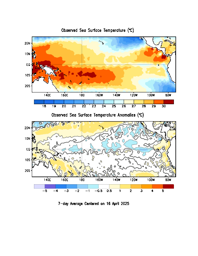
http://www.cpc.ncep.noaa.gov/products/a ... week_c.gif
I don’t expect this warming to have much if any adverse effect on the evolution of the pattern over the western hemisphere since its probably not sustainable, and the strength of the Anomalous SSTs are < +1.0 C. The strong ENSO events of the past 30 years (1982-83, 1991-92, 1997-98) have seen SSTA in this region as high as +4.5 C.
Recall in the WINTER OUTLOOK I outlined my case for why this EN event will only reach weak to perhaps Borderline Moderate at the MOST; never coming close to attaining strong intensity or holding a candle to some of the better recognized events of the past thirty years. I also suggested that it would peak in the EARLY PORTION of the winter before declining during the late winter and dissipating in the spring—like 1963-64.
What is the reason for these ups and downs in the 1+2 region SSTA? The Answer is manifested in changes in short term fluctuations in zonal winds over the region which act as a mechanism which regulates large-scale changes in both Sea Surface and Sub Surface Ocean temps. We can track these changes by monitoring the depth of the EQUATORIAL THERMOCLINE (which separates the warmer upper ocean waters from the colder lower ocean). In El Nino events, the thermocline in the 1+2 region is deep or in cases of a strong event nearly flat.
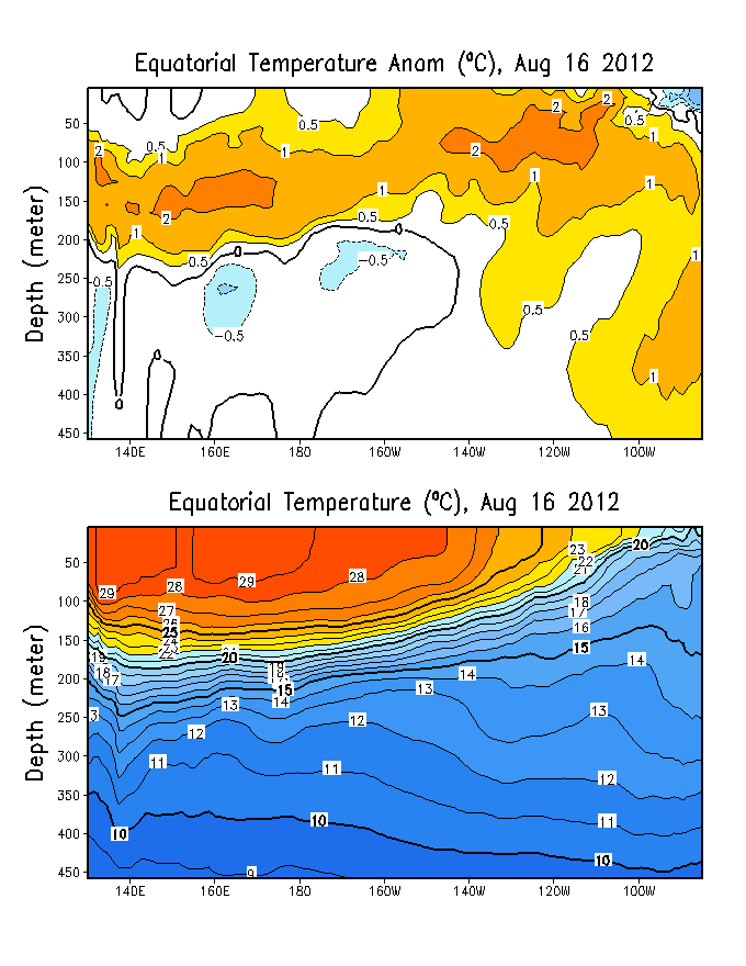
Above is a plot showing equatorial Sub-surface ocean temperatures and anomalies for NOV 9 (y-axis is the ocean depth (m) and the x-axis is the Longitude ranging from 140E to 100W).
Between 160E and 140W there is a pronounced area of sub-surface warmth. This area is coincident w/ the region of the greatest Positive Sea surface temperature anomalies in the 4.0 and 3.4 regions.
This latest warming episode coincided nicely with enhanced westerly zonal winds over the eastern EQPAC.
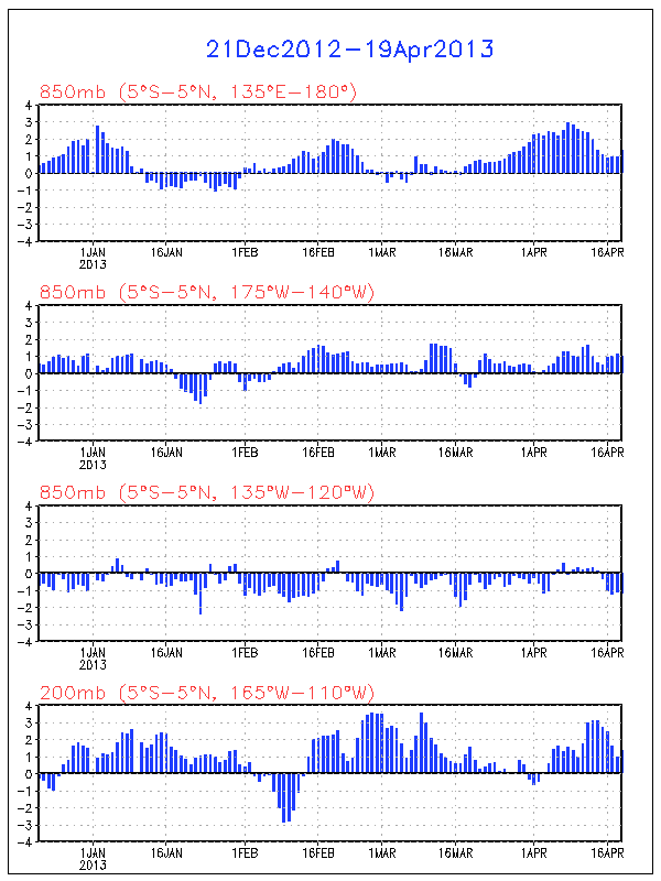
Note the negative values over the 3.0 region and eastern portions of the 1+2 region indicating westerly 850mb U over the region. This is consistent w/ reduced upwelling and an increase in SSTA over the region. At h200 easterly anomalies have been noted which is also consistent w/ El Nino conditions (LLVL westerly anomalies below upper level easterlies). This would also indicate a weaker than normal Hadley-walker cell.
Here is a time-longitude section of h850 U anomalies

These westerly wind bursts in the Low levels can accompany eastward propagating Kelvin waves, and a strongly –SOI.
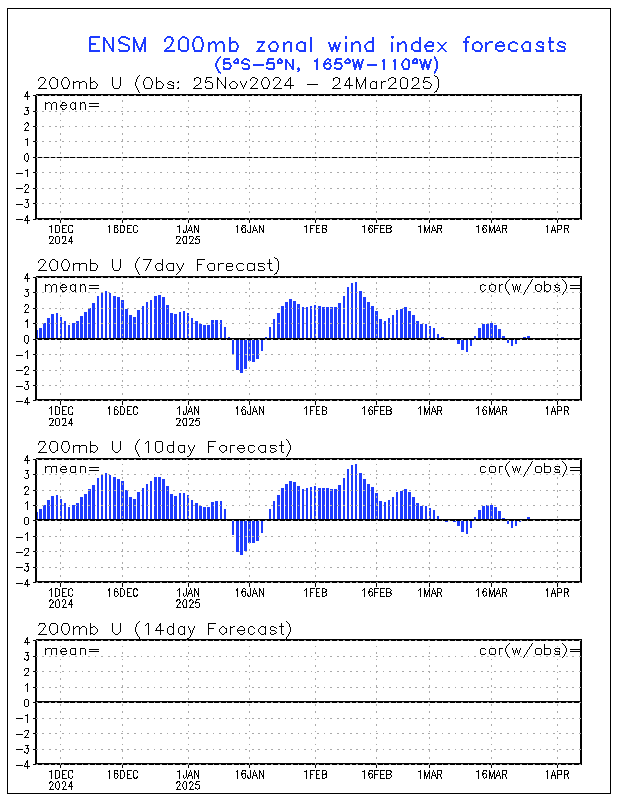
The Ensembles are indicating that easterly h200 U anomalies this will continue over the next 14 days, which is favorable for continued warming.
Westerly anomalies are also forecasted to continue at h850
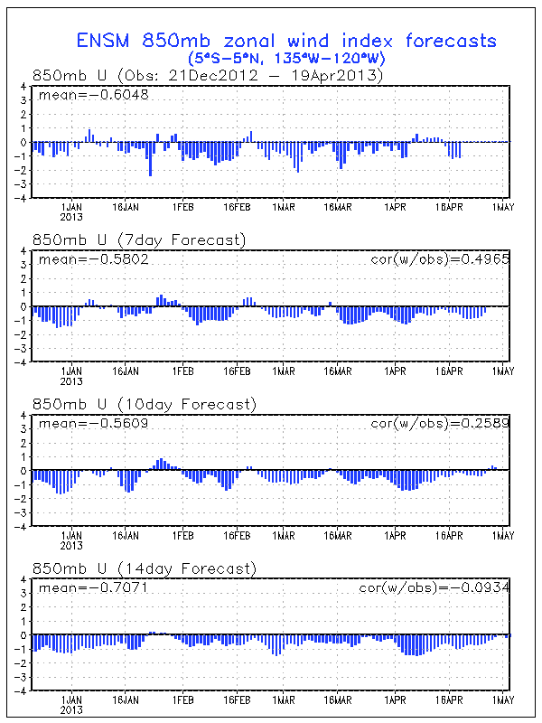
Both of these indices indicate a persistence of the current SSTA set-up over the equatorial pacific. Further warming or related variations should be dictated by the SOI and MJO.
A –SOI pulse can have similar warming effects since it forces a weakening the equatorial easterlies. Prior to the current upsurge in SSTA over the 1+2 region, the SOI dipped strongly negative.
2-Nov-2004 1010.80 1009.60 -10.60 -3.94 -4.45
3-Nov-2004 1010.24 1009.90 -16.10 -4.49 -4.51
4-Nov-2004 1008.56 1009.50 -24.30 -5.30 -4.61
5-Nov-2004 1007.36 1008.55 -25.90 -5.79 -4.88
6-Nov-2004 1008.16 1008.35 -19.50 -6.04 -5.03
7-Nov-2004 1011.09 1009.95 -11.00 -6.02 -5.08
Another noteworthy issue would be if the SOI which has been consistently negative in the means were to go positive in DEC. Some of the years which had a predominantly negative SOI that spiked positive during the OND period have tended to be BRUTAL winters in the EUS. Those years include:
1965, 1968, 1969, 1976, 1985, 1986, 1993. It almost happened in 1957 and 2002 where there was an upsurge but the SOI never got into positive territory for a month or more. We will have to see what DEC holds.


During the winter of 1963-64, the SOI was consistently through the OND period. If OND 2004 follows suit, it could strengthen 1963-64’s credibility as a viable analog.


The SOI values of 2003-04 have also resembled those of 1962-63 leading up to the winter of 1963-64.
http://www.bom.gov.au/climate/current/soihtm1.shtml
Issue # 2…the Plains system—a catalyst for the forthcoming pattern change over North America.
The weak ridge off the east coast and position of the longwave trough over the Rockies and western plains (near 100W at 72hrs) and lack of a Greenland block or 50-50 low will prevent this from being an eastern US event.
Going on the 12z ECMWF depiction of the Sequence of events…A piece of Southern stream energy which gets kicked out into NM and west TX on TUE will eventually lift northward and phase with a digging PJ s/w over the western lakes on WED and THU forming a large closed upper low just north of lake superior. The SLP will deepen significantly while tracking from TX to NRN Indiana.
Too early to deal w/ the specifics, however suffice to say there will be a significant snowfall north and west of the track of the SFC low w/ the potential for a large SVR wx outbreak in the warm sector. Recall we discussed the possibility for such an event at the end of last week and during the weekend.
The 12z OP-GGEM is similar to the 12z ECMWF as were the 0z Canadian ensembles w/ the piece of STJ energy being kicked out of the SW and phasing w/ the PJ energy over the Midwest. Both SLP tracks are pretty much indistinguishable also.
http://meteocentre.com/models/gemglb_am ... _panel.gif
http://www.meteo.psu.edu/~gadomski/ENSCMCHGT_0z/f96.gif
0z UKMET was further east w/ the track of the SLP which goes from TX to near ERI (Erie, PA) by 0z NOV 25 while deepening to 994mb.
http://meteocentre.com/models/ukmet_ame ... _panel.gif
This track would shift the area of snowfall further eastward. If correct, look out south central MI, NRN IN, and perhaps Chicago. CLE could get clipped w/ the wraparound. And again, SVR threat in the warm sector.
The 0z GFS was much further NW as is the case w/ the 12z run having the SLP located over the UP of MI.
http://www.nco.ncep.noaa.gov/pmb/nwprod ... 6_120l.gif
http://www.nco.ncep.noaa.gov/pmb/nwprod ... 6_108l.gif
It would appear that the UKMET is the furthest east w/ the system and the GFS the outlier to the NW w/ the GGEM and ECMWF being the mid ground.
Remember though that the GFS is the model which is run at three different resolutions. From 0-144 hrs on the 0z cycle the GFS Is run at a grid resolution of 55km (T254) whereas the other globals are run at a consistent resolution w/o truncation to a different resolution. So the 0z GFS interpretation of the system is probably better than the 12z since between 84 and 240 hrs the GFS is run at a 77km/T170 resolution. From 240-384hrs at 0z/12z the GFS is run w/ a 108km /T126 resolution. The GFS truncation issue is one of the biggest problems with the model, in addition to the so far uncorrected cold bias and tendency for over phasing and over amplification east of the Rockies. An example of the GFS warm season problems is gridscale feedback that sets off the convective scheme and puts down a HUGE amount of QPF over a gridpoint. This can be traced back to problems with the models convective parameterization scheme.
The ECMWF is run w/ a 25 KM resolution through D10, the GGEM is run at about 85km through 240hrs and the NGP uses a 60km resolution. This issue of the GFS resolution came up quite a bit during the hurricane season, but is equally important during the winter.
The over phasing problem is the result of not only the truncation issue but potentially sparse RAOB data over a given location where the system or piece of energy is located (SW US or the PAC for example)
Issue # 3…pattern change.
The pattern change is set in motion once the closed low over the lakes region in the vort lobe on THU tilts STRONGLY negative while lifting northeastward toward Nova Scotia where it takes on the role of a 50-50 low and pumps the ridge downstream of it over Greenland.
http://www.sca.uqam.ca/models/ecmwf_ame ... 9panel.gif
This sets up a CLASSIC rex blocking pattern over the North Atlantic and sends NAO goes strongly negative. Notice how the low pressure center directly south of the blocking high.

Behind the cold front, the cold air comes rushing into the EUS.


At the same time the ridge over the EPAC amplifies, and attempts to hook up with the block north of Alaska’s arctic coast. This would force the PV to reform further south.
IF at some point down the road the western ridge can hook up with the block over the north Atlantic the pattern could be forced into extreme amplification as the PV becomes displaced well to the south of its climatological position.
Down the road further w/ the new pattern in place the potential exists for a larger winter storm in the EUS between the NOV 25 and DEC 1 w/ the Greenland block in place, 50-50 low and PV nosing down toward Hudson bay.


