Florida Needs to Hope the Atlantic Ridge Collapses for TD #5

This is the general tropical discussion area. Anyone can take their shot at predicting a storms path.

Moderator: S2k Moderators

Forum rules

The posts in this forum are NOT official forecasts and should not be used as such. They are just the opinion of the poster and may or may not be backed by sound meteorological data. They are NOT endorsed by any professional institution or STORM2K. For official information, please refer to products from the National Hurricane Center and National Weather Service.

Help Support Storm2K
Message
Author
User avatar
gatorcane
S2K Supporter
S2K Supporter
Posts: 23703
Age: 47
Joined: Sun Mar 13, 2005 3:54 pm
Location: Boca Raton, FL

Florida Needs to Hope the Atlantic Ridge Collapses for TD #5

#1 Postby gatorcane » Sun Jul 10, 2005 10:31 pm

The peninsula was saved twice this year already by a stronger than normal western atlantic ridge (Dennis and TS. Cindy) but as I've been saying it may end up steering storms into the state come August/Sept....looks like TD #5 is going to ridge the southern edge of the ridge.
0 likes   

User avatar
gatorcane
S2K Supporter
S2K Supporter
Posts: 23703
Age: 47
Joined: Sun Mar 13, 2005 3:54 pm
Location: Boca Raton, FL

#2 Postby gatorcane » Sun Jul 10, 2005 10:32 pm

ridge -> ride
0 likes   

texasheat

#3 Postby texasheat » Sun Jul 10, 2005 10:32 pm

wayyyyy to far out to tell bro
0 likes   

User avatar
gatorcane
S2K Supporter
S2K Supporter
Posts: 23703
Age: 47
Joined: Sun Mar 13, 2005 3:54 pm
Location: Boca Raton, FL

#4 Postby gatorcane » Sun Jul 10, 2005 10:33 pm

it's far out but the ridge really built in a few weeks ago and doesn't appear to be going away anytime soon.
0 likes   

User avatar
Stratusxpeye
Category 2
Category 2
Posts: 686
Joined: Tue Jun 07, 2005 10:40 am
Location: Tampa, Florida
Contact:

#5 Postby Stratusxpeye » Sun Jul 10, 2005 10:38 pm

nOT LIKING The GFDL Model at all. no Way. Its got a cat 4 north of the islands thrashing through the bahamas and up the middle of florida. Crazy Sruff.
0 likes   

User avatar
gatorcane
S2K Supporter
S2K Supporter
Posts: 23703
Age: 47
Joined: Sun Mar 13, 2005 3:54 pm
Location: Boca Raton, FL

#6 Postby gatorcane » Sun Jul 10, 2005 10:39 pm

nOT LIKING The GFDL Model at all. no Way. Its got a cat 4 north of the islands thrashing through the bahamas and up the middle of florida. Crazy Sruff.


It's very early still but if the ridge holds as it's been doing for the past few weeks it will move right into the E. coast of FL somewhere :eek:
0 likes   

THead
S2K Supporter
S2K Supporter
Posts: 790
Joined: Mon Aug 30, 2004 5:09 pm
Location: Lauderhill, Fla./Jefferson, Ga.

#7 Postby THead » Sun Jul 10, 2005 10:47 pm

If the ridge holds, wouldn't it just keep the storm down south of florida, and push it into the GOM again, like dennis?
0 likes   

User avatar
deltadog03
Professional-Met
Professional-Met
Posts: 3580
Joined: Tue Jul 05, 2005 6:16 pm
Location: Macon, GA

#8 Postby deltadog03 » Sun Jul 10, 2005 10:47 pm

boca_chris wrote:
nOT LIKING The GFDL Model at all. no Way. Its got a cat 4 north of the islands thrashing through the bahamas and up the middle of florida. Crazy Sruff.


It's very early still but if the ridge holds as it's been doing for the past few weeks it will move right into the E. coast of FL somewhere :eek:


in an early call, a stronger more SW moving ridge..it will stay south of fl...and head westward into the gulf
0 likes   

texasheat

#9 Postby texasheat » Sun Jul 10, 2005 10:48 pm

wait.. as of now if the would the storm move into the west gulf beacuse of the ridge or go to flrodai
0 likes   

THead
S2K Supporter
S2K Supporter
Posts: 790
Joined: Mon Aug 30, 2004 5:09 pm
Location: Lauderhill, Fla./Jefferson, Ga.

#10 Postby THead » Sun Jul 10, 2005 10:48 pm

Hehe, Jinx! deltadog!

:D
0 likes   

gkrangers

#11 Postby gkrangers » Sun Jul 10, 2005 10:49 pm

THead wrote:If the ridge holds, wouldn't it just keep the storm down south of florida, and push it into the GOM again, like dennis?
Not necessarily. The ridge is forecasted to have a bit of weakness in it north of the lesser antilles..which will let the storm ove wnw-nw towards puerto rico and hispaniola. Then the ridge strenghthens to the west, steering the storm towards the Bahamas and US coastline.

The ridge always kept Dennis very far south....TD5 is gonna be brought north due to that weakness, then resume a westerly course around the periphery of the ridge once the ridge gets its strenght back. Thats the idea right now.
0 likes   

User avatar
HURAKAN
Professional-Met
Professional-Met
Posts: 46086
Age: 38
Joined: Thu May 20, 2004 4:34 pm
Location: Key West, FL
Contact:

#12 Postby HURAKAN » Sun Jul 10, 2005 10:50 pm

Sorry to disturb everyone so early in the life of TD 5 but looks at the map of the NHC three days out, and look at the ridge to the north. By the way, say hi to possible "Franklin" behind TD 5.
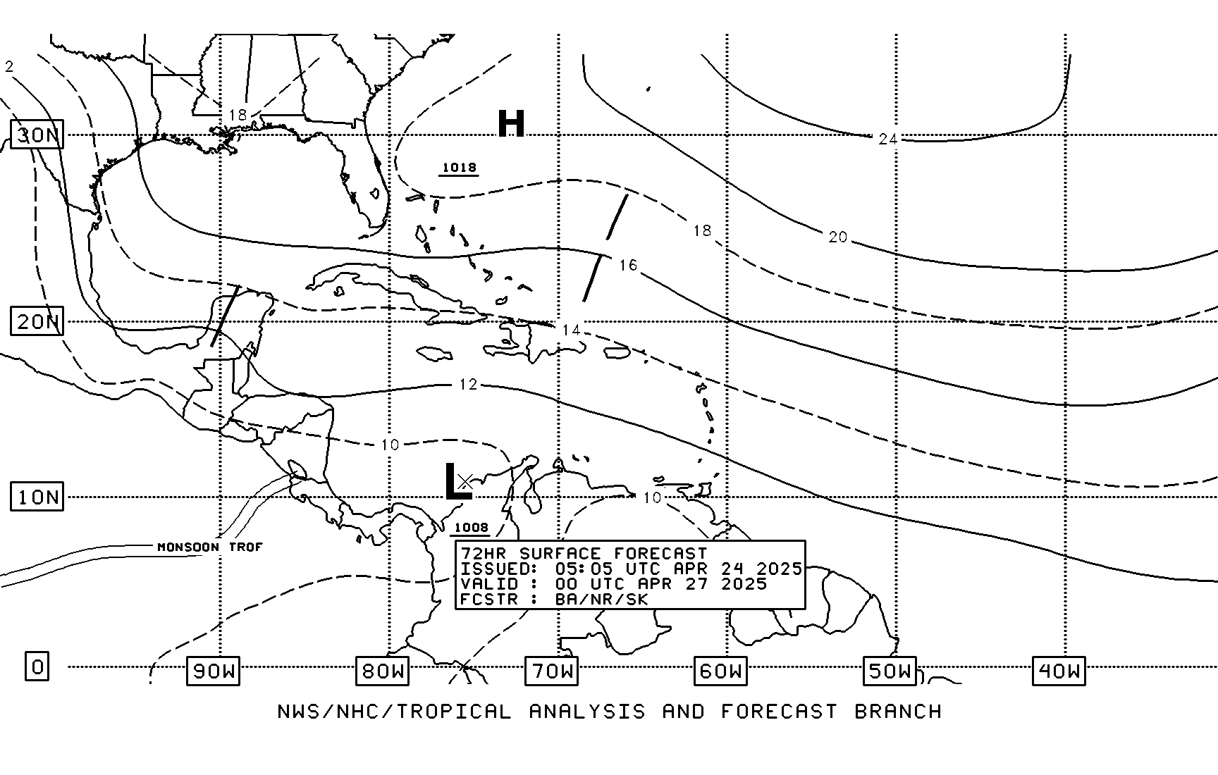
Image
Last edited by HURAKAN on Sun Jul 10, 2005 10:52 pm, edited 2 times in total.
0 likes   

User avatar
deltadog03
Professional-Met
Professional-Met
Posts: 3580
Joined: Tue Jul 05, 2005 6:16 pm
Location: Macon, GA

#13 Postby deltadog03 » Sun Jul 10, 2005 10:50 pm

THead wrote:Hehe, Jinx! deltadog!

:D


LOL....if the ridge builds in...this could be the pattern that would send her into the western gulf...imo...don't start bashing..lol
0 likes   

User avatar
cinlfla
Category 2
Category 2
Posts: 687
Joined: Mon Aug 16, 2004 7:16 pm
Location: Titusville, Florida on the Spacecoast

#14 Postby cinlfla » Sun Jul 10, 2005 10:59 pm

Sorry to disturb everyone so early in the life of TD 5 but looks at the map of the NHC three days out, and look at the ridge to the north. By the way, say hi to possible "Franklin" behind TD 5.


I have a question about the map you just posted. What are the arrows pointing to the X's?
0 likes   

User avatar
air360
Category 1
Category 1
Posts: 447
Joined: Sat Sep 04, 2004 3:48 pm
Location: Morehead City, NC
Contact:

#15 Postby air360 » Sun Jul 10, 2005 11:17 pm

the expected tracks of the systems i would guess
0 likes   

User avatar
gatorcane
S2K Supporter
S2K Supporter
Posts: 23703
Age: 47
Joined: Sun Mar 13, 2005 3:54 pm
Location: Boca Raton, FL

#16 Postby gatorcane » Mon Jul 11, 2005 7:04 am

it's not looking good for S. Florida right now
0 likes   

Patrick99
Category 5
Category 5
Posts: 1772
Joined: Mon May 24, 2004 3:43 pm
Location: SW Broward, FL

#17 Postby Patrick99 » Mon Jul 11, 2005 7:11 am

boca_chris wrote:it's not looking good for S. Florida right now


I expect to hear this several more times this season...all I know is that if we are in the initial 5-day "cone," that's a sure bet it won't hit S. FL. hehe - at this point, I'd probably raise an eyebrow more if the cone was set a little right or left of us - then we'd worry about the inevitable "model trend"
0 likes   

User avatar
EDR1222
S2K Supporter
S2K Supporter
Posts: 1253
Joined: Mon Nov 10, 2003 12:58 pm
Location: Melbourne, FL

#18 Postby EDR1222 » Mon Jul 11, 2005 7:30 am

Obviously things can change at any time, but Stacy Stewart hinted at it earlier in the year that last year there was a flip flop in steering patters from the previous 8 years and that it was unlikely that it would change right back to where it was before last year. Still possible however.

But the ridge definately established itself a few weeks ago.
0 likes   

margaritabeach
Tropical Depression
Tropical Depression
Posts: 76
Joined: Sun Sep 05, 2004 2:29 pm

#19 Postby margaritabeach » Mon Jul 11, 2005 7:31 am

floater #1 is now over TD 5
0 likes   

User avatar
Zadok
Tropical Storm
Tropical Storm
Posts: 232
Joined: Sun Aug 29, 2004 7:32 am
Location: USA East Coast

#20 Postby Zadok » Mon Jul 11, 2005 7:41 am

It looks like Florida is getting set up for the 1,2,3 punch again this year. It looks like it's fixen to be Florida east coasts turn next week. Bad news.
0 likes   


Return to “Talkin' Tropics”

Who is online

Users browsing this forum: No registered users and 349 guests