
Texas Winter 2015-2016
Moderator: S2k Moderators
Forum rules
 The posts in this forum are NOT official forecast and should not be used as such. They are just the opinion of the poster and may or may not be backed by sound meteorological data. They are NOT endorsed by any professional institution or STORM2K.

The posts in this forum are NOT official forecast and should not be used as such. They are just the opinion of the poster and may or may not be backed by sound meteorological data. They are NOT endorsed by any professional institution or STORM2K.

Re: Texas Winter 2015-2016
If it's worth anything, the Canadian looks a bit like the GFS now with maybe snow from I-20 N towards the Red River and NW. 850s are more than efficient to produce above our heads
So does the Ukmet with the precip. But I can't tell what the surface temperatures are with the free stuff. 850s is cold, 540 thickness is in central Texas
So does the Ukmet with the precip. But I can't tell what the surface temperatures are with the free stuff. 850s is cold, 540 thickness is in central Texas
0 likes
The above post and any post by Ntxw is NOT an official forecast and should not be used as such. It is just the opinion of the poster and may or may not be backed by sound meteorological data. It is NOT endorsed by any professional institution including Storm2k. For official information, please refer to NWS products.
Help support Storm2K!
-
Ralph's Weather
- S2K Supporter

- Posts: 3374
- Age: 38
- Joined: Fri Dec 13, 2013 11:55 am
- Location: Lindale, TX
- Contact:
Re: Texas Winter 2015-2016
06Z GFS looks like it shifted towards the Euro. Things look more suppressed, at least the cold is there.
0 likes
Follow on Facebook at Ralph's Weather.
-
orangeblood
- S2K Supporter
- Posts: 3895
- Joined: Tue Dec 15, 2009 6:14 pm
- Location: Fort Worth, TX
Re: Texas Winter 2015-2016
Great Article explaining our frustrations with the GFS, why the Euro is King, and why the lack of leadership and vision has hindered the GFS from earning the throne!!!
http://scitation.aip.org/content/aip/magazine/physicstoday/article/69/1/10.1063/PT.3.3046
http://scitation.aip.org/content/aip/magazine/physicstoday/article/69/1/10.1063/PT.3.3046
0 likes
-
orangeblood
- S2K Supporter
- Posts: 3895
- Joined: Tue Dec 15, 2009 6:14 pm
- Location: Fort Worth, TX
Re: Texas Winter 2015-2016
Very disappointing pattern developing on the models....AO, EPO forecast to pop positive again, after this week most of the ensembles lock any below normal temps on the other side of the globe, and just as the MJO was trekking into the very favorable phases for cold/stormy US weather, it crashes into the 'circle of death'. Not good!!!

0 likes
-
srainhoutx

- S2K Supporter
- Posts: 6919
- Age: 68
- Joined: Sun Jan 14, 2007 11:34 am
- Location: Haywood County, NC
- Contact:
Re: Texas Winter 2015-2016
orangeblood wrote:Very disappointing pattern developing on the models....AO, EPO forecast to pop positive again, after this week most of the ensembles lock any below normal temps on the other side of the globe, and just as the MJO was trekking into the very favorable phases for cold/stormy US weather, it crashes into the 'circle of death'. Not good!!!
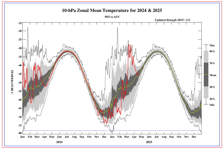
Careful with those AO predictions. There are other factors at work on a Hemispheric scale such as very strong warming at the Stratospheric level. The current warming event is the strongest we have seen so far this Winter Season.

Last edited by srainhoutx on Thu Jan 14, 2016 9:54 am, edited 1 time in total.
0 likes
Carla/Alicia/Jerry(In The Eye)/Michelle/Charley/Ivan/Dennis/Katrina/Rita/Wilma/Ike/Harvey
Member: National Weather Association
Wx Infinity Forums
http://wxinfinity.com/index.php
Facebook.com/WeatherInfinity
Twitter @WeatherInfinity
Member: National Weather Association
Wx Infinity Forums
http://wxinfinity.com/index.php
Facebook.com/WeatherInfinity
Twitter @WeatherInfinity
-
Ralph's Weather
- S2K Supporter
- Posts: 3374
- Age: 38
- Joined: Fri Dec 13, 2013 11:55 am
- Location: Lindale, TX
- Contact:
Re: Texas Winter 2015-2016
srainhoutx wrote:Careful with those AO predictions. There are other factors at work on a Hemispheric scale such as very strong warming in at the Stratospheric level. The current warming event is the strongest we have seen so far this Winter Season.
That is a pretty impressive warming episode and that will likely offset the lack of tropical forcing.
0 likes
Follow on Facebook at Ralph's Weather.
-
orangeblood
- S2K Supporter
- Posts: 3895
- Joined: Tue Dec 15, 2009 6:14 pm
- Location: Fort Worth, TX
Re: Texas Winter 2015-2016
Just look at the Stratosphere in 1997-98, above normal warming throughout the winter months but never translated to cold in the Lower 48. The Pacific just overwhelmed the pattern that year and it appears to be repeating itself....

This year
0 likes
-
Portastorm

- Storm2k Moderator

- Posts: 9955
- Age: 63
- Joined: Fri Jul 11, 2003 9:16 am
- Location: Round Rock, TX
- Contact:
Re: Texas Winter 2015-2016
Pardon me for venting ... BUT ... we can get a freakin' January hurricane in the Atlantic for the first time in half a century ... but we can't get snow in Austin. 
0 likes
Any forecasts under my name are to be taken with a grain of salt. Get your best forecasts from the National Weather Service and National Hurricane Center.
-
orangeblood
- S2K Supporter
- Posts: 3895
- Joined: Tue Dec 15, 2009 6:14 pm
- Location: Fort Worth, TX
Re: Texas Winter 2015-2016
Monday's system is starting to become more potent on model runs....pretty impressive Arctic front blasting through with post-frontal precip breaking out in sub-freezing surface temps


0 likes
Re: Texas Winter 2015-2016
Portastorm wrote:Pardon me for venting ... BUT ... we can get a freakin' January hurricane in the Atlantic for the first time in half a century ... but we can't get snow in Austin.
That is crazy. Looks like the "A" hurricane came early this year. On to "B"!!
0 likes
-
Tireman4

- S2K Supporter
- Posts: 5904
- Age: 60
- Joined: Fri Jun 30, 2006 1:08 pm
- Location: Humble, Texas
- Contact:
Re: Texas Winter 2015-2016
gpsnowman wrote:Portastorm wrote:Pardon me for venting ... BUT ... we can get a freakin' January hurricane in the Atlantic for the first time in half a century ... but we can't get snow in Austin.
That is crazy. Looks like the "A" hurricane came early this year. On to "B"!
0 likes
Any forecasts under my name are to be taken with a grain of salt. Get your best forecasts from the National Weather Service and National Hurricane Center.

Re: Texas Winter 2015-2016
CAT 1 IN THE EASTERN ATLANTIC !!!!! Alex is born!
Nobody had that one coming.
Nobody had that one coming.
0 likes
The above post and any post by dhweather is NOT an official forecast and should not be used as such. It is just the opinion of the poster and may or may not be backed by sound meteorological data. It is NOT endorsed by any professional institution including storm2k.org. For official information, please refer to NWS products.
Re: Texas Winter 2015-2016
Portastorm wrote:If anyone had doubts about the GFS' ability to handle the current pattern ... just compare the overnight 0z op run with the just issued 12z run. Look at the surface low depiction for this weekend over Texas. The 0z run had the surface low just west of Austin. The 12z run has it 125 miles south of Brownsville. What's a difference of 400-some miles between friends, right?!
GFS has been going towards the Euro, but thats not to say the euro has been better. Its not Cuba anymore. Also the euro had a deep S Tx snow threat this weekend some days that isn't going to happen. Model that shows least snow is the winner
0 likes
The above post and any post by Ntxw is NOT an official forecast and should not be used as such. It is just the opinion of the poster and may or may not be backed by sound meteorological data. It is NOT endorsed by any professional institution including Storm2k. For official information, please refer to NWS products.
Help support Storm2K!
Help support Storm2K!
-
weatherdude1108
- Category 5

- Posts: 4228
- Joined: Tue Dec 13, 2011 1:04 pm
- Location: Northwest Austin/Cedar Park, TX
Re: Texas Winter 2015-2016
Portastorm wrote:If anyone had doubts about the GFS' ability to handle the current pattern ... just compare the overnight 0z op run with the just issued 12z run. Look at the surface low depiction for this weekend over Texas. The 0z run had the surface low just west of Austin. The 12z run has it 125 miles south of Brownsville. What's a difference of 400-some miles between friends, right?!
I just saw that. What in the world?!?!

How on Earth are our trusted experts supposed to base forecasts on that kind of output?
I have noticed during the most recent weather events that the GFS tends to move troughs (or other weather systems) around different latitudes in each successive run, not having it right until the day of.
0 likes
The preceding post is NOT an official forecast, and should not be used as such. It is only the opinion of the poster and may or may not be backed by sound meteorological data. It is NOT endorsed by any professional institution including storm2k.org. For Official Information please refer to the NHC and NWS products.
-
orangeblood
- S2K Supporter
- Posts: 3895
- Joined: Tue Dec 15, 2009 6:14 pm
- Location: Fort Worth, TX
Re: Texas Winter 2015-2016
weatherdude1108 wrote:Portastorm wrote:If anyone had doubts about the GFS' ability to handle the current pattern ... just compare the overnight 0z op run with the just issued 12z run. Look at the surface low depiction for this weekend over Texas. The 0z run had the surface low just west of Austin. The 12z run has it 125 miles south of Brownsville. What's a difference of 400-some miles between friends, right?!
I just saw that. What in the world?!?!
How on Earth are our trusted experts supposed to base forecasts on that kind of output?
I have noticed during the most recent weather events that the GFS tends to move troughs (or other weather systems) around different latitudes in each successive run, not having it right until the day of.
Read the article I posted above, explains most everything you need to know about why the GFS is what it is....pretty simple explanation, it's run by the United State Government!
0 likes


Re: Texas Winter 2015-2016
Like I said before.... if you want cold air well down into Texas you need decent HP's We have had very little of that this winter.. look at Canada right now.. Nada... Also flow seems so fast any cold air that comes down seems to be routed rather quickly. I don't know if this is going to change honestly. With this pattern we need cold air northwest of here, and strong H500 disturbance. Air positioned due north of here which in other more typical winters could reach us, will not. So when I saw the shift to a bit more eastern based cold... I was like meh...
You don't need models to seem whats happening.... Besides past five days they have been pretty useless up to this point.
You don't need models to seem whats happening.... Besides past five days they have been pretty useless up to this point.
0 likes
Anything I post is my personal opinion and should not used for any type of planning or lifesaving reasons. Please refer to National Weather Service forecasts.
Re: Texas Winter 2015-2016
Sure, there's plenty of time for winter storms to happen, but we are just about at halftime. I wonder at what point/if Joe Bastardi will admit "we were wrong" ?
0 likes
The above post and any post by dhweather is NOT an official forecast and should not be used as such. It is just the opinion of the poster and may or may not be backed by sound meteorological data. It is NOT endorsed by any professional institution including storm2k.org. For official information, please refer to NWS products.
-
northjaxpro

- S2K Supporter
- Posts: 8900
- Joined: Mon Sep 27, 2010 11:21 am
- Location: Jacksonville, FL
Re: Texas Winter 2015-2016
But, we have yet to get a very large discharge of arctic air to drop south into the CONUS just yet. It appears the split flow pattern is locked in place for the time being.
I agree that a really good discharge of arctic air has to settle in place in most instances, for Texas and the Deep South to have the best chance of seeing a very significant winter storm. This year especially this is the case, given the series of Southern Stream storm systems riding along the subtropical jet. We have seen several of these systems already this season, but we have lacked the deep, arctic airmass to be in place for these southern stream systems to undercut them to produce wintry fun.
Hang in there. We still have February to get through, so we will see if we can get a 1050ish mb High to drop down south.
Last edited by northjaxpro on Thu Jan 14, 2016 2:00 pm, edited 2 times in total.
0 likes
NEVER, EVER SAY NEVER in the tropics and weather in general, and most importantly, with life itself!!
________________________________________________________________________________________
Fay 2008 Beryl 2012 Debby 2012 Colin 2016 Hermine 2016 Julia 2016 Matthew 2016 Irma 2017 Dorian 2019
________________________________________________________________________________________
Fay 2008 Beryl 2012 Debby 2012 Colin 2016 Hermine 2016 Julia 2016 Matthew 2016 Irma 2017 Dorian 2019
Who is online
Users browsing this forum: No registered users and 153 guests