ATL: IRMA - Models
Moderator: S2k Moderators
-
South Texas Storms

- Professional-Met

- Posts: 4256
- Joined: Thu Jun 24, 2010 12:28 am
- Location: Houston, TX
Re: ATL: IRMA - Models
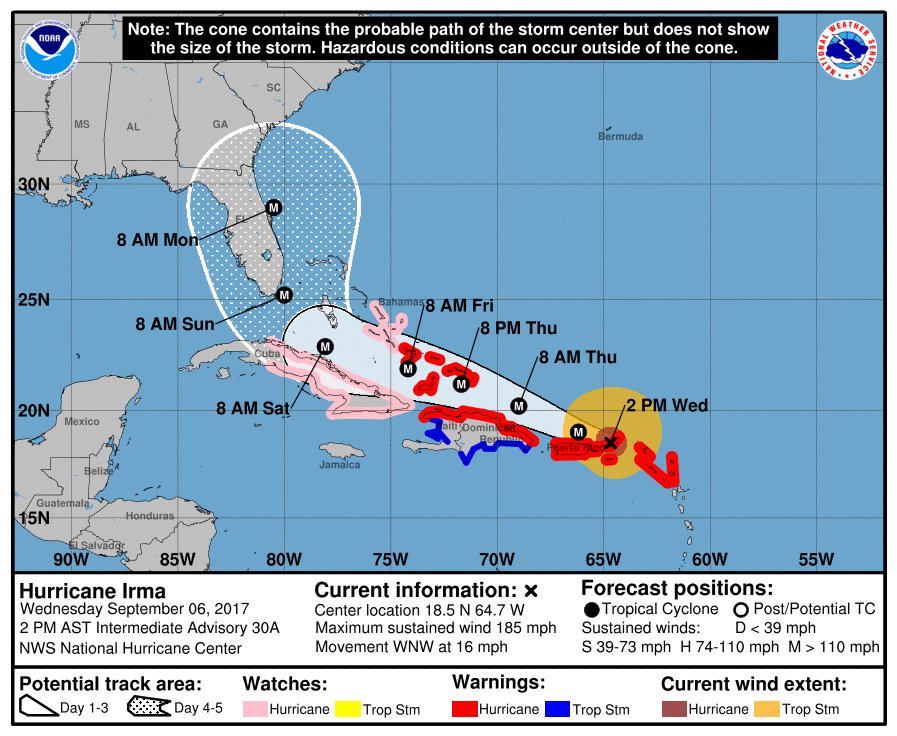
Pretty good consensus for 4-5 days out between most of the models of a landfall near Miami and then a track up or just off the east coast of Florida.
2 likes
-
gtalum

- S2K Supporter

- Posts: 4749
- Age: 50
- Joined: Tue Sep 07, 2004 3:48 pm
- Location: Bradenton, FL
- Contact:
Re: ATL: IRMA - Models
TheStormExpert wrote:Just when we were getting a consensus the Euro goes and throws a wrench in things.

It's basically in consensus with GFS and the official NHC track.
1 likes
Re: ATL: IRMA - Models
Euro exists to the Atlantic at around St. Augustine at 120 HRS. That's a lot of inland real estate it goes over.
Edit: More like Daytona.
Edit: More like Daytona.
Last edited by miamijaaz on Wed Sep 06, 2017 1:31 pm, edited 1 time in total.
2 likes
-
tolakram
- Admin

- Posts: 20179
- Age: 62
- Joined: Sun Aug 27, 2006 8:23 pm
- Location: Florence, KY (name is Mark)
Re: ATL: IRMA - Models

1 likes
M a r k
- - - - -
Join us in chat: Storm2K Chatroom Invite. Android and IOS apps also available.
The posts in this forum are NOT official forecasts and should not be used as such. Posts are NOT endorsed by any professional institution or STORM2K.org. For official information and forecasts, please refer to NHC and NWS products.
-
AutoPenalti
- Category 5

- Posts: 4091
- Age: 29
- Joined: Mon Aug 17, 2015 4:16 pm
- Location: Ft. Lauderdale, Florida
Re: ATL: IRMA - Models
If you want to extrapolate the track a bit, it would essentially put Metro Dade and Broward in the eye AND, I believe, the NE quadrant.
I really wish Euro wasn't 24 hours though...
I really wish Euro wasn't 24 hours though...
Last edited by AutoPenalti on Wed Sep 06, 2017 1:28 pm, edited 1 time in total.
0 likes
The posts in this forum are NOT official forecasts and should not be used as such. They are just the opinion of the poster and may or may not be backed by sound meteorological data. They are NOT endorsed by any professional institution or STORM2K. For official information, please refer to products from the NHC and NWS.
Model Runs Cheat Sheet:
GFS (5:30 AM/PM, 11:30 AM/PM)
HWRF, GFDL, UKMET, NAVGEM (6:30-8:00 AM/PM, 12:30-2:00 AM/PM)
ECMWF (1:45 AM/PM)
TCVN is a weighted averaged

Re: ATL: IRMA - Models
miamijaaz wrote:Euro exists to the Atlantic at around St. Augustine at 120 HRS. That's a lot of inland real estate it goes over.
would head over the Everglades and then clip Orlando...would come right over my house
0 likes
Just like Jon Snow..."I know nothing" except what I know, and most of what I know is gathered by the fine people of the NHC

Re: ATL: IRMA - Models
Now just offshore of Florida at 120. Would be nice to know the path it took to get there.
2 likes


Re: ATL: IRMA - Models
Hello,
This is my first ever post here on Storm 2K!! Been on site since Charley here in Orlando and want to say this is the best forum out there!! Thanks for keeping us informed on whats going on as this is a dangerous situation for all here in the mainland. Have noticed models flip flooping everywhere but wanted to say no matter what we have to stop looking at a certain point. The storm is over 400 miles in diameter so pretty much the whole state of Florida will be impacted someway somehow. Wanted to ask since im no expert what type of winds would we realistically feel here in Orlando. Fox35 said at least 100mph earlier in morning. Wanted to see how valid that statement was. Keep up the good work guys doing great.
This is my first ever post here on Storm 2K!! Been on site since Charley here in Orlando and want to say this is the best forum out there!! Thanks for keeping us informed on whats going on as this is a dangerous situation for all here in the mainland. Have noticed models flip flooping everywhere but wanted to say no matter what we have to stop looking at a certain point. The storm is over 400 miles in diameter so pretty much the whole state of Florida will be impacted someway somehow. Wanted to ask since im no expert what type of winds would we realistically feel here in Orlando. Fox35 said at least 100mph earlier in morning. Wanted to see how valid that statement was. Keep up the good work guys doing great.
2 likes


Re: ATL: IRMA - Models
Dean4Storms wrote:Keep in mind 4 days ago the official NHC track had Irma passing well to the north of the Islands, things can and will likely change. Could be further east or further west or right where the ECM is painting it this afternoon.
It can but now that we have atmospheric data into the models and they seem to be coming into some sort of consensus, I doubt there will be that much of a difference.
1 likes
Re: ATL: IRMA - Models
Hoo boy. If that verifies it will be chaos for a while in the state, and points north 
1 likes
Re: ATL: IRMA - Models
miamijaaz wrote:Euro exists to the Atlantic at around St. Augustine at 120 HRS. That's a lot of inland real estate it goes over.
Closer to Daytona in that run... either way worst case scenario for the entire east coast of Florida
0 likes

Re: ATL: IRMA - Models
Really wish the Euro wasn't 24 hr periods. Not enough detail. Can't tell if it's heading N or NNE after it hits Florida.
Last edited by Vdogg on Wed Sep 06, 2017 1:47 pm, edited 1 time in total.
1 likes
-
tolakram
- Admin
- Posts: 20179
- Age: 62
- Joined: Sun Aug 27, 2006 8:23 pm
- Location: Florence, KY (name is Mark)
Re: ATL: IRMA - Models
Vdogg wrote:Really wish the Euro wasn't 24 he periods. Not enough detail. Can't tell if it's heading N or NNE after it hits Florida.
The eye hugs the east coast, on shore, exiting near Daytona.
1 likes
M a r k
- - - - -
Join us in chat: Storm2K Chatroom Invite. Android and IOS apps also available.
The posts in this forum are NOT official forecasts and should not be used as such. Posts are NOT endorsed by any professional institution or STORM2K.org. For official information and forecasts, please refer to NHC and NWS products.
- - - - -
Join us in chat: Storm2K Chatroom Invite. Android and IOS apps also available.
The posts in this forum are NOT official forecasts and should not be used as such. Posts are NOT endorsed by any professional institution or STORM2K.org. For official information and forecasts, please refer to NHC and NWS products.
-
Stangfriik
- Tropical Storm

- Posts: 114
- Joined: Tue Jul 26, 2005 2:25 pm
- Location: Daytona Beach, Florida
- Contact:
Re: ATL: IRMA - Models
Steve wrote:Those ensembles show a marked shift back to a threat centered very near Miami, FL. They are more consolidated now, so I think GFS is honing in. For all the people trying to scoff at this down in FL (the Matthew 2, blah blah blah folks), maybe they'll get a wakeup call in this or succeeding runs? Some people I know, know to check with me for advice because they know I am always ahead of the curve (props to S2K for that). Other people believe what they hear or panic off of Facebook spaghetti plots or whatever. 12Z trends so far are definitely not good for SE FL. And as I said earlier, we're now getting to the point with the models where they will become more accurate with every 6 or 12 hour increment. Let people squawk and say or post what they want on social media. Luckily all of us already know better.
FWIW, 12Z NAVGEM is filling in. 96 hours has it right over Islamorada and heading for the Everglades which it hits from the South. It stays in Florida all the way to 114 hours where the eastern eyewall is coming back offshore around New Smyrna Beach. This is a bad track for metro Orlando where most of the metro should probably expect Cat 1 at a minimum (though NAVGEM is eh at best). 120 Hours it's right over Jacksonville Beach with a little bit over 1/2 of the eye offshore. That's a good 6 hour ride along the coast with both sides of the eyewall.
It pulls back in on the GA Coast for good.
Well that's reassuring being in New Smyrna lol
1 likes
-
northjaxpro

- S2K Supporter
- Posts: 8900
- Joined: Mon Sep 27, 2010 11:21 am
- Location: Jacksonville, FL
Re: ATL: IRMA - Models
Yeah, it is really getting clearer now on a consensus that the entire Florida peninsula is likely to get severely impacted by Irma. This run has shifted right up the spine of the state.
The models have zoned in this scenario or at minimum, the East Coast scrapper all the way up the coast.
Either scenario would be catastrophic no matter how you slice it. .
The models have zoned in this scenario or at minimum, the East Coast scrapper all the way up the coast.
Either scenario would be catastrophic no matter how you slice it. .
3 likes
NEVER, EVER SAY NEVER in the tropics and weather in general, and most importantly, with life itself!!
________________________________________________________________________________________
Fay 2008 Beryl 2012 Debby 2012 Colin 2016 Hermine 2016 Julia 2016 Matthew 2016 Irma 2017 Dorian 2019
________________________________________________________________________________________
Fay 2008 Beryl 2012 Debby 2012 Colin 2016 Hermine 2016 Julia 2016 Matthew 2016 Irma 2017 Dorian 2019
-
tolakram
- Admin
- Posts: 20179
- Age: 62
- Joined: Sun Aug 27, 2006 8:23 pm
- Location: Florence, KY (name is Mark)
Re: ATL: IRMA - Models
Second landfall GA/SC border @ 132 hours

2 likes
M a r k
- - - - -
Join us in chat: Storm2K Chatroom Invite. Android and IOS apps also available.
The posts in this forum are NOT official forecasts and should not be used as such. Posts are NOT endorsed by any professional institution or STORM2K.org. For official information and forecasts, please refer to NHC and NWS products.
- - - - -
Join us in chat: Storm2K Chatroom Invite. Android and IOS apps also available.
The posts in this forum are NOT official forecasts and should not be used as such. Posts are NOT endorsed by any professional institution or STORM2K.org. For official information and forecasts, please refer to NHC and NWS products.
-
gtalum
- S2K Supporter
- Posts: 4749
- Age: 50
- Joined: Tue Sep 07, 2004 3:48 pm
- Location: Bradenton, FL
- Contact:
Re: ATL: IRMA - Models
Vdogg wrote:Really wish the Euro wasn't 24 he periods. Not enough detail. Can't tell if it's heading N or NNE after it hits Florida.
Looks pretty darn close to due north to me.
0 likes

Re: ATL: IRMA - Models
NHC
Euro
NHC
HWRF

CMC

GEFS

Make no mistake. We have a damn good consensus now.
Euro
NHC
HWRF
CMC
GEFS
Make no mistake. We have a damn good consensus now.
6 likes

Re: ATL: IRMA - Models
Someone needs to post the high resolution Euro - Forecasterjack you around?
0 likes
Who is online
Users browsing this forum: No registered users and 19 guests