Kingarabian wrote:June Canadian seasonal has weak La Nina for ASO:
https://i.postimg.cc/XvDXksYJ/image.png It is initializing SST anomalies @ Nino 4 and Nino 3.4 wrong though, about 0.3/0.5 degree off. It's still favoring a cooler Nino 4 and Nino 3.4 and a warmer Nino 3 and Nino 1+2.
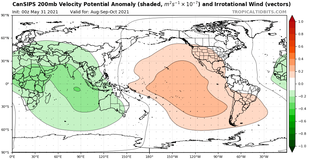
This setup has failed to materialize despite repeated model forecasts.VP200 forecast favors a very active Atlantic hurricane season -- with a more favorable VP200 signature for July compared to what the 46 days EPS is currently showing.
https://i.postimg.cc/8PhHX6WD/image.png
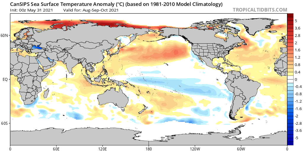
Compared to May’s run, the June CanSIPS has actually trended toward a weaker -ENSO signature by ASO, along with a more positive or warm neutral PDO. Additionally, while the coolest SST are still concentrated in Niño 3.4+4, they are far weaker (less pronounced) than on May’s run, and Niño 1+2 are actually cooler on the latest run, so if one were to extrapolate the run-to-run trend it would favour cool neutral ENSO centred in Niño 1+2 during ASO. The MDR, while still relatively cool compared to the subtropics, is also notably warmer vs. the previous run, and the ITCZ is actually wetter as well, so the overall trend is toward a more conducive setup for a hyperactive Atlantic season, as the textbook 200-mb -VE signature suggests. The very strong African monsoon depicted on the run would likely result in a warmer (eastern) MDR is suggested by the model during the peak of the season. 1999 remains a very good analog in terms of ongoing and future SST evolution in the Atlantic basin. The trend toward cool neutral ENSO vs. weak Niña and a potentially warmer PDO by peak season may actually be worse for the Florida peninsula and possibly the extreme eastern Gulf of Mexico:
The increase during neutral phases (relative to cold phases) in landfalls along the Florida and Gulf coasts for hurricanes classified as tropical storms east of 50°W allows the authors to hypothesize that a variation in the steering flow exists during neutral phases. The hypothetical variation in the steering flow seems to keep tropical cyclones forming in the eastern tropical North Atlantic on a more southerly track during a neutral ENSO phase, thereby decreasing the probability of East Coast landfalls.
Source